Aurora forecast diminishes; omega block makes for dry last week of April in the Maritimes
 There are many great pictures of a very visible aurora over the Maritimes Sunday night into early Monday morning. This photo from Roxana Soeebeer was taken at Skiff Lake, N.B.
There was quite a show in the night sky for the Maritimes this past weekend! A severe geomagnetic storm (G4) produced a widespread viewing of the aurora borealis Sunday night into early Monday morning.
Some great pictures in the region of that are available here.
Don’t expect a repeat performance Monday night. The Space Weather Prediction Center branch of the NOAA has only a minor geomagnetic storm forecast (G1) for Monday night/Tuesday morning, making it much less likely to spot the aurora.
 There are many great pictures of a very visible aurora over the Maritimes Sunday night into early Monday morning. This photo from Roxana Soeebeer was taken at Skiff Lake, N.B.I also had reports of a few “fireballs” associated with the Lyrid meteor shower. The Lyrids reached their peak this past weekend, but may still be visible, cloud cover permitting. The radiant point is near the bright star Vega in the constellation Lyra, which move high in the eastern sky near and after midnight. More cloudiness and fog is expected in the Maritimes Monday night compared to the weekend. That is likely to make night sky viewing more challenging.
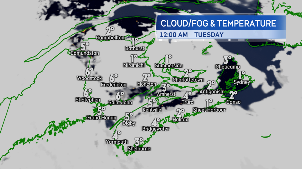 The aurora is not expected to be as active again Monday night -- it’s just as well as more cloud and fog is expected to be present in the region compared to the weekend.On to the weather story for the week, which is going to be the lack of rain in the forecast. A blocking pattern in the jet stream -- faster moving winds high in the atmosphere -- will allow a ridge of high pressure to remain in place much of this week, giving us a very low chance of any significant amount of rain. This particular blocking pattern is known as an “omega block” as it resembles the Greek letter omega.
Omega blocks are infamous for producing extended periods of dry weather. Aside from only a low chance of some very spotty, light showers Tuesday and Thursday, rain looks like it will hold off until at least early next week.
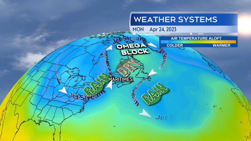 The jet stream is currently locked up in an Omega Block over eastern Canada. The Maritimes finds itself in the drier portion of that weather pattern.”While the dry weather has been favourable for the freshet in New Brunswick, allowing river water levels to continue to come down this week, getting too dry for too long this time of the year can create other issues. The fire weather index will need to be watched in the Maritimes. While that isn’t being rated particularly high yet, it is important that people continue to adhere to any provincial or municipal burn restrictions in effect. A complicating factor this year could be debris left by post-tropical storm Fiona adding to ground fuel available for wildfires. At the end of March, the Agriculture and Agri-Food Canada drought monitor only had a small area of southern New Brunswick rated as “abnormally dry.” March wasn’t a particularly dry month for the Maritimes. The organization should have an update to the drought monitor out in early May.
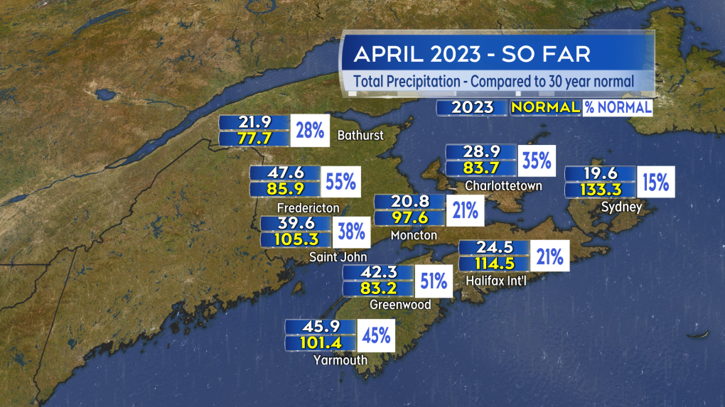 April has been, and will finish, dry in comparison with 30-year climate averages.More on the omega block, the dry weather, and regional weather conditions on CTV News at 5, 6, and 11:30 p.m.
CTVNews.ca Top Stories

opinion Tom Mulcair: Prime Minister Justin Trudeau's train wreck of a final act
In his latest column for CTVNews.ca, former NDP leader and political analyst Tom Mulcair puts a spotlight on the 'spectacular failure' of Prime Minister Justin Trudeau's final act on the political stage.
B.C. mayor gets calls from across Canada about 'crazy' plan to recruit doctors
A British Columbia community's "out-of-the-box" plan to ease its family doctor shortage by hiring physicians as city employees is sparking interest from across Canada, says Colwood Mayor Doug Kobayashi.
'There’s no support': Domestic abuse survivor shares difficulties leaving her relationship
An Edmonton woman who tried to flee an abusive relationship ended up back where she started in part due to a lack of shelter space.
opinion King Charles' Christmas: Who's in and who's out this year?
Christmas 2024 is set to be a Christmas like no other for the Royal Family, says royal commentator Afua Hagan. King Charles III has initiated the most important and significant transformation of royal Christmas celebrations in decades.
Baseball Hall of Famer Rickey Henderson dead at 65, reports say
Rickey Henderson, a Baseball Hall of Famer and Major League Baseball’s all-time stolen bases leader, is dead at 65, according to multiple reports.
Arizona third-grader saves choking friend
An Arizona third-grader is being recognized by his local fire department after saving a friend from choking.
Germans mourn the 5 killed and 200 injured in the apparent attack on a Christmas market
Germans on Saturday mourned the victims of an apparent attack in which authorities say a doctor drove into a busy outdoor Christmas market, killing five people, injuring 200 others and shaking the public’s sense of security at what would otherwise be a time of joy.
Blake Lively accuses 'It Ends With Us' director Justin Baldoni of harassment and smear campaign
Blake Lively has accused her 'It Ends With Us' director and co-star Justin Baldoni of sexual harassment on the set of the movie and a subsequent effort to “destroy' her reputation in a legal complaint.
Oysters distributed in B.C., Alberta, Ontario recalled for norovirus contamination
The Canadian Food Inspection Agency has issued a recall due to possible norovirus contamination of certain oysters distributed in British Columbia, Alberta and Ontario.


