Coastal storm may bring heavy snow to Nova Scotia Tuesday and Wednesday
A low pressure system out of Texas will rapidly intensify into a coastal storm near New England by Tuesday morning.
The storm will then track south and east of Nova Scotia but will likely come close enough to bring heavy snowfall and high wind to parts of that province.
Timing
Monday night through Tuesday morning will be generally fair. Snow and blowing snow will develop in southwestern Nova Scotia Tuesday afternoon. Weather conditions across much of Nova Scotia will deteriorate by and through Tuesday evening. Eastern Prince Edward Island could also get into snow and blowing snow Tuesday night and Wednesday. Only a lighter snow or flurries are expected for southern areas of New Brunswick at this time.
Western Nova Scotia is expected to be through the snow by Wednesday morning. Pictou, Antigonish, Guysborough, and Cape Breton, along with Queens and Kings counties in Prince Edward Island, may have to contend with further snow squalls through Wednesday night. Those additional snow squalls are expected to ease and diminish by Thursday morning.
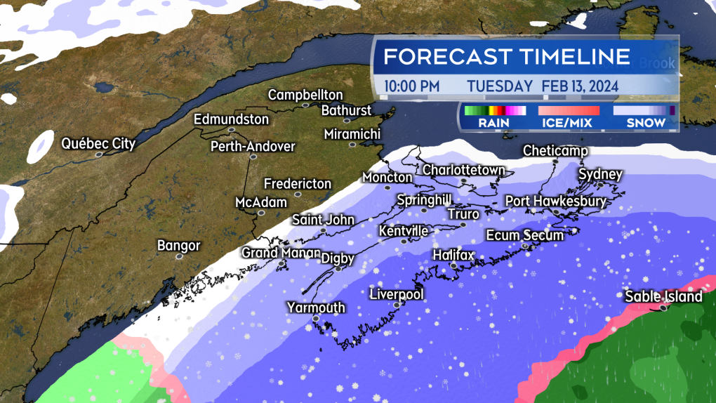 Snow and blowing snow develops west to east across Nova Scotia Tuesday afternoon through evening. (Source: CTV News Atlantic)
Snow amounts
A large area of Nova Scotia could see snow totals of 10-to-30 cm. The highest snow totals are more likely in two areas. The first are the Atlantic coastal counties of Nova Scotia being closest to the passing storm. The second is Pictou/Antigonish/Inverness counties, as well as Kings County, P.E.I. For those areas there is a risk additional snow squalls off the Gulf of St. Lawrence could bring in localized snow amounts of 10-to-20 cm Wednesday afternoon through Thursday morning. You will likely need to check for cancellations and delays related to the snow for Wednesday if you are in an area where it is heavier.
Snow is expected to be much lighter for western Prince Edward Island and southern New Brunswick. Central and northern areas of New Brunswick are not expected to receive snow from the storm.
Winter Storm Watches and Winter Storm Warnings have been posted by Environment Canada for the province of Nova Scotia.
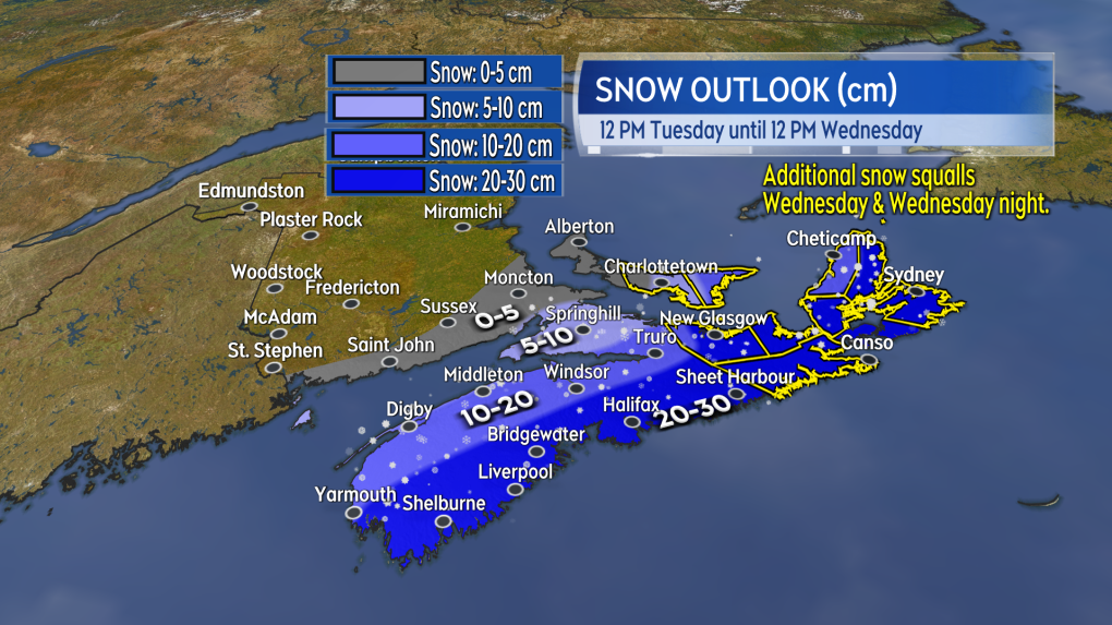 Possible snow Tuesday noon through Wednesday noon. (Source: CTV News Atlantic)
Wind
A high northerly wind will accompany the snow Tuesday into the night. Peak gusts ranging 40-to-70 km/h for Nova Scotia and Prince Edward Island except up to 80 km/h on exposed areas of the Atlantic coastline of Nova Scotia. The wind could create blowing and drifting snow.
The wind will become northwest by Wednesday afternoon. Sustained 20-to-40 km/h with gusts of 40-to-60 km/h for the region. The gusty northwest wind will persist into Thursday. A lighter wind is expected Friday.
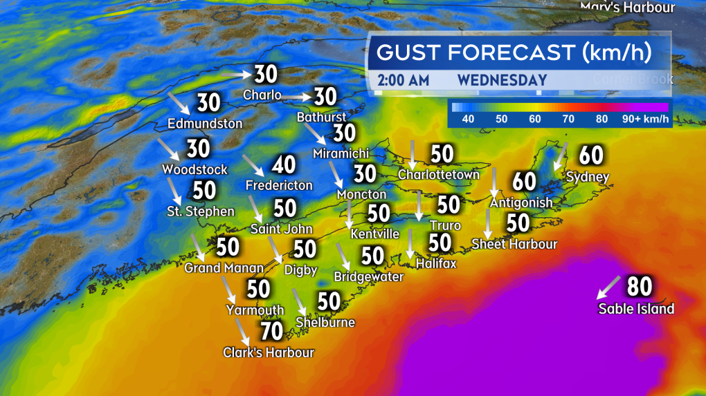 A high and gusty northerly wind will accompany the snow Tuesday evening and night for Nova Scotia and Prince Edward Island. (Source: CTV News Atlantic)
Watch the forecast
It is highly recommended that you continue to check in on your forecast Tuesday and Wednesday, especially if you are in or travelling through Prince Edward Island or Nova Scotia during that time. There has been an extreme amount of variance in weather models for this storm. Some continue to bring heavier snowfall amounts near 30 cm further into Nova Scotia while others hold the heaviest snow just offshore of that province. It is not just our region that is contending with that uncertainty at the moment as they are struggling with it in eastern U.S. as well where the storm will arrive before coming to us.
I’ll have updates, timelines, and region weather conditions on CTV News Atlantic programming at 5, 6, and 11:30 p.m.
For more Nova Scotia news visit our dedicated provincial page.
Shopping Trends
The Shopping Trends team is independent of the journalists at CTV News. We may earn a commission when you use our links to shop. Read about us.


CTVNews.ca Top Stories

Trump suggests the U.S. should take back the Panama Canal. Could they do that?
Donald Trump suggested Sunday that his new administration could try to regain control of the Panama Canal that the United States 'foolishly' ceded to its Central American ally, contending that shippers are charged 'ridiculous' fees to pass through the vital transportation channel linking the Atlantic and Pacific Oceans.
Man handed 5th distracted driving charge for using cellphone on Hwy. 417 in Ottawa
An Ottawa driver was charged for using a cellphone behind the wheel on Sunday, the fifth time he has faced distracted driving charges.
Wrongfully convicted N.B. man has mixed feelings since exoneration
Robert Mailman, 76, was exonerated on Jan. 4 of a 1983 murder for which he and his friend Walter Gillespie served lengthy prison terms.
What's open and closed over the holidays in Canada
As Canadians take time off to celebrate the holidays, many federal offices, stores and businesses will be closed across the country on Christmas Day and New Year's Day.
opinion
opinion Christmas movies for people who don't like Christmas movies
The holidays can bring up a whole gamut of emotions, not just love and goodwill. So CTV film critic Richard Crouse offers up a list of Christmas movies for people who might not enjoy traditional Christmas movies.
Can the Governor General do what Pierre Poilievre is asking? This expert says no
A historically difficult week for Prime Minister Justin Trudeau and his Liberal government ended with a renewed push from Conservative Leader Pierre Poilievre to topple this government – this time in the form a letter to the Governor General.
More than 7,000 Jeep SUVs recalled in Canada over camera display concern
A software issue potentially affecting the rearview camera display in select Jeep Wagoneer and Grand Cherokee models has prompted a recall of more than 7,000 vehicles.
'I'm still thinking pinch me': lost puppy reunited with family after five years
After almost five years of searching and never giving up hope, the Tuffin family received the best Christmas gift they could have hoped for: being reunited with their long-lost puppy.
10 hospitalized after carbon monoxide poisoning in Ottawa's east end
The Ottawa Police Service says ten people were taken to hospital, with one of them in life-threatening condition, after being exposed to carbon monoxide in the neighbourhood of Vanier on Sunday morning.
Toronto
-
Snowfall coming to several parts of the GTA on Monday: Environment Canada
Monday’s commute to and from work could be a snowy one for people throughout the GTA.
-
Police identify man who died after being stabbed in Toronto’s Corso Italia area, man charged with second-degree murder
Toronto police have identified a man who died following after being stabbed during a “protracted altercation” in Toronto’s Corso Italia area over the weekend.
-
1 injured in Rexdale jewelry store robbery
One person has been injured after an unknown number of suspects drove a vehicle into the front of a jewelry store in north Etobicoke and stole merchandise.
Calgary
-

Police looking for driver involved in pedestrian collision in downtown Calgary.
One person is in hospital after being struck by an SUV in downtown Calgary early Saturday morning,
-
It was Grandma, in the cafe with a Scrabble tile: Game cafes are big holiday business
It’s the holidays, which means for many across the Prairies, there’s no better time to get locked in a dungeon with a dragon.
-
Calgary Firefighters Toy Association throws a Christmas party for thousands of kids at Telus Centre
The Calgary Firefighters Toy Association threw a Christmas party Sunday afternoon for about 4,000 kids at the Telus Convention Centre.
Edmonton
-

'There’s no support': Domestic abuse survivor shares difficulties leaving her relationship
An Edmonton woman who tried to flee an abusive relationship ended up back where she started in part due to a lack of shelter space.
-
opinion
opinion Christmas movies for people who don't like Christmas movies
The holidays can bring up a whole gamut of emotions, not just love and goodwill. So CTV film critic Richard Crouse offers up a list of Christmas movies for people who might not enjoy traditional Christmas movies.
-
AMA fundraiser for Alberta food banks nets more than $322,000
A provincial fundraiser this year has gathered its highest annual amount ever.
Montreal
-

Workers helping the homeless in Montreal feel powerless as crisis deepens
Social workers on the front lines of homelessness in Montreal say they feel increasingly powerless as more people find themselves forced to live in tents during the winter.
-
Two vehicles set on fire in Montreal in suspected arson attacks
Montreal police is investigating after two vehicles were set ablaze in different parts of the city.
-
Jewellery store robbery in Parc-Extension under investigation
Montreal police (SPVM) are investigating a robbery that occurred at a Jewellery store robbery in Parc-Extension under investigation store in the Parc-Extension neighborhood on Saturday evening.
Ottawa
-
 NEW THIS MORNING
NEW THIS MORNING The Papery returns to historic home in Ottawa's Glebe neighbourhood after fire
Nearly two years after a devastating fire on Boxing Day in 2022, The Papery has reopened at its original location in the heart of the Glebe.
-
10 hospitalized after carbon monoxide poisoning in Ottawa's east end
The Ottawa Police Service says ten people were taken to hospital, with one of them in life-threatening condition, after being exposed to carbon monoxide in the neighbourhood of Vanier on Sunday morning.
-
WINTER TRAVEL ADVISORY
WINTER TRAVEL ADVISORY 10-20 cm of snow expected in Ottawa starting Monday
Environment Canada has issued a winter weather travel advisory for Ottawa with 10-20 centimetres of snow in the forecast on Monday.
London
-

Standoff in Seaforth at the centre of SIU investigation
Following a standoff in Seaforth on Friday, the province’s police watch dog is investigating an officer’s conduct.
-
More than 7,000 Jeep SUVs recalled in Canada over camera display concern
A software issue potentially affecting the rearview camera display in select Jeep Wagoneer and Grand Cherokee models has prompted a recall of more than 7,000 vehicles.
-
Did you buy a Lotto Max ticket in Lambton County? Check it!
If you bought a Lotto Max ticket in Lambton County, you could be a big winner.
Barrie
-
Who ordered a white Christmas?
National meteorologists might be breathing a sigh of relief when they see the forecast this week.
-
Residents startled by blue flashes in the sky during power outage in Barrie
A power outage on Saturday night left over a thousand Barrie homes in the dark.
-
Police allege man failed to steal car after finding out it was standard
Barrie Police are looking for a male suspect involved in an alleged car theft attempt that ended up being unsuccessful.
Northern Ontario
-

OPP investigating fatal collision Saturday in northwest Ontario
Ontario Provincial Police are investigating a fatal collision that occurred on Saturday evening in northwestern Ontario.
-
Can the Governor General do what Pierre Poilievre is asking? This expert says no
A historically difficult week for Prime Minister Justin Trudeau and his Liberal government ended with a renewed push from Conservative Leader Pierre Poilievre to topple this government – this time in the form a letter to the Governor General.
-
Northern Ont. man illegally killed three moose, one deer
A man from the northwestern Ontario community of Dinorwic has been found guilty of multiple hunting offences and fined $6,500, banned from hunting for five years and placed on probation for 18 months.
Kitchener
-

WR Grassroots Response expands support for displaced Ukrainians with new guest house in Centre Wellington
Displaced Ukrainians finding refuge in Ontario have a new haven thanks to Grassroots Response to the Ukrainian Crisis, a Waterloo Region-based not-for-profit.
-
Can the Governor General do what Pierre Poilievre is asking? This expert says no
A historically difficult week for Prime Minister Justin Trudeau and his Liberal government ended with a renewed push from Conservative Leader Pierre Poilievre to topple this government – this time in the form a letter to the Governor General.
-
Driver in Kitchener charged after going 180km/h in 70km/h zone
A G2 driver has been charged after going 110km over the speed limit in Kitchener Sunday morning.
Windsor
-

'Giving back': Kingsville store hands out free fresh groceries ahead of the holidays
Cars lined up outside of Cindy’s Home and Garden store in Kingsville on Sunday morning for the first Green Pick-up Holiday Food Drive-Thru.
-
More than 7,000 Jeep SUVs recalled in Canada over camera display concern
A software issue potentially affecting the rearview camera display in select Jeep Wagoneer and Grand Cherokee models has prompted a recall of more than 7,000 vehicles.
-
Looking for a last minute stocking stuffer? This local fundraiser has the thing for you.
If you’re looking for a stocking stuffer idea, consider the Kiwanis Camp Lottery Calendar! It offers $14,000 worth of prizes, including a cash prize every month and a gift up for grabs every week throughout next year.
Winnipeg
-

Minnesota-Manitoba border airport permanently shutting down after 70 years
An airport with a runway that spans across the Canada-U.S. border will close for good by the end of this week.
-
Manitoba man hopes to sell parts of unique, homemade musical instrument collection
Eighty-eight-year-old Lorne Collie has been making musical instruments for more than three decades, creations that dazzle for their unique materials as much as their sound.
-
Man attacks family with bear spray after vehicle collision: WPS
A Winnipeg man is facing several weapon-related charges after police said he attacked a family with bear spray.
Regina
-

'Lots to learn': Regina's new mayor embracing role with budget debate right around the corner
Regina's recently elected Mayor Chad Bachynski has been embracing the learning curve that comes with the role and is looking ahead to the new year, which will include finalizing the city's budget.
-
'For the community, by the community': Regina's Sikh community helping fight food insecurity
Regina's Sikh community has been helping feed those less fortunate in Regina for over seven years.
-
Gathering held in Regina to recognize Winter Solstice
Regina's mâmawêyatitân centre held a day of gathering for the Winter Solstice on Saturday.
Saskatoon
-
Sask. woman dead following crash on Highway 5
A 69-year-old woman from the Humboldt area is dead after her SUV collided with a truck on Highway 5, according to police.
-
Sask. police investigating mischief incident after bomb report in school
Prince Albert police are investigating a mischief incident after a bomb report in a school Friday afternoon.
-
Prince Albert woman collects donations to make Christmas hampers for community
A Prince Albert woman is spreading holiday cheer by organizing Christmas hampers for those in need.
Vancouver
-

Second body recovered from site of B.C. landslide
The second resident of a home that was destroyed by a landslide in Lions Bay, B.C., last weekend was found dead Saturday, officials confirmed.
-
Boxes of Love brightens the season for families in need with holiday hampers
Hundreds of holiday hampers went out to low-income families across Metro Vancouver over the weekend as part of the annual Boxes of Love campaign.
-
Facing hometown Canucks 'a bit surreal' for Sharks rookie Celebrini
Macklin Celebrini grew up dreaming of playing NHL hockey at Rogers Arena. On Monday, that dream becomes a reality.
Vancouver Island
-

More strong winds hit parts of B.C.'s coast as record-high temperatures recorded
What has been a windy weekend for parts of B.C.’s coast continued Sunday as Environment Canada issued a fresh set of wind warnings.
-
Drug superlabs leave a toxic mess. Some say B.C.'s cleanup rules are a mess, too
As clandestine drug labs become larger and more complex, so does the toxic mess they leave behind and the tools required to clean them up, creating expensive and dangerous situations for both people and the environment.
-
Second body recovered from site of B.C. landslide
The second resident of a home that was destroyed by a landslide in Lions Bay, B.C., last weekend was found dead Saturday, officials confirmed.
Kelowna
-

Forfeited Hells Angels clubhouse in Kelowna, B.C., sold to the city
A former Hells Angels clubhouse that was seized by the British Columbia government in 2023 after years of fighting in court has been sold to the City of Kelowna.
-
Death of woman found in Kelowna's Waterfront Park in June deemed 'non-criminal in nature': RCMP
Police in Kelowna say a death they began investigating back in June has now been confirmed as "non-criminal in nature."
-
B.C. man sentenced for 'execution-style' murder of bystander in drug trade conflict
A B.C. man convicted of the "intentional and ruthless killing of a bystander" while acting as an enforcer in the drug trade has been sentenced for a second time in the slaying.


