Colorado Low will skirt Maritimes, lighter snow and rain expected this weekend
 A car is seen as light snow falls in this undated stock image. (Shutterstock)
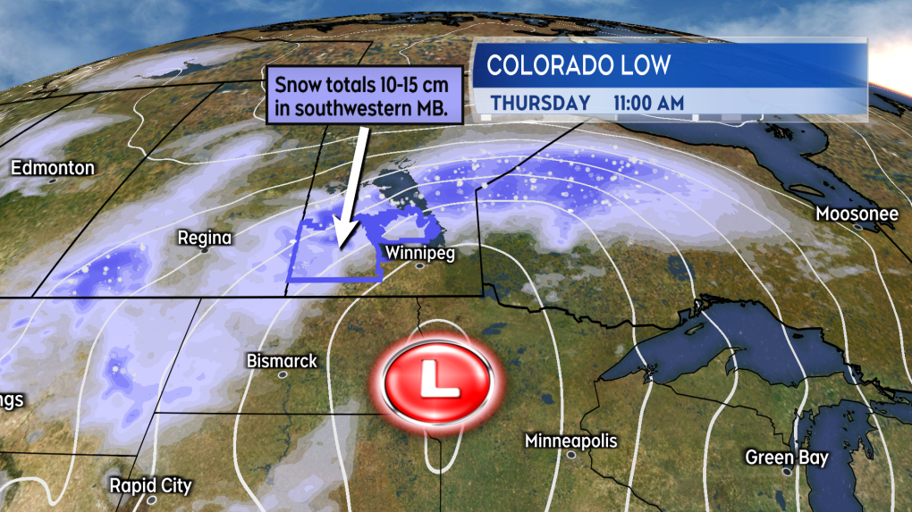
A Colorado Low, so named because it originates on the eastern side of the Rockies near that state, is bringing 10 to 15 cm of snow to parts of southern Manitoba today.
The centre of the system then moves through Northern Ontario and into Northern Quebec. While not coming directly across the Maritimes, it will sweep a couple of weather fronts through this weekend. The result will be some relatively mild February temperatures and a passing mix of snow and rain.
 The Colorado Low responsible for some heavier snow in parts of Manitoba.
A few flurries or showers, along with increasing cloudiness, is expected in the Maritimes Saturday. The coverage of any flurries or showers will be quite spotty around the region. High temperatures on Saturday will range from 4 to 7 degrees in New Brunswick and Nova Scotia, most communities of Prince Edward Island will see a high near 3. For reference, the average high temperature for this time of February is mostly -1 to -4.
 Increasing cloudiness and milder temperatures Saturday. Some isolated flurries or showers.
On Sunday, a lighter mix of snow and rain comes across the Maritimes. No significant snow accumulation is expected, with indications that it may only be the higher terrain of northern New Brunswick that could pick up some snow amounts near 5 cm. There will be a total of 2 to 10 mm of rain and showers.
While the milder temperatures will encourage melting of the tremendous amount of snow down in parts of the Maritimes after the weekend storm, the further compaction of the snow could continue to make it more difficult to clear. Even a few millimetres of rain will add additional weight to that snow and, if possible, snow should be continued to be cleared from areas vulnerable to that weight, including roofs and decks. Extreme caution should be taken in clearing of roofs as not only can it be dangerous but there is also a risk of damaging roofing material if not done correctly.
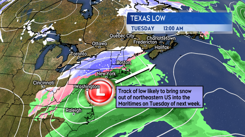
 Watch the forecast for Tuesday next week. It has more potential to see a widespread snowfall return to the Maritimes.
It is not enough rain to produce a higher risk of flooding. Keep in mind that some area drainage systems are likely buried and blocked by snow. With the melt this weekend that is likely to lead to som
The next storm system we need to watch for in the long range forecast is a low-pressure system moving out of Texas at the end of the weekend. The track of that system looks likely to come close enough to the Maritimes to risk a more widespread snowfall on Tuesday of next week. There are early indications that could be heavier snow for some areas with heavier defined as amounts of 15 cm or more.
CTVNews.ca Top Stories

Trump suggests the U.S. should take back the Panama Canal. Could they do that?
Donald Trump suggested Sunday that his new administration could try to regain control of the Panama Canal that the United States 'foolishly' ceded to its Central American ally, contending that shippers are charged 'ridiculous' fees to pass through the vital transportation channel linking the Atlantic and Pacific Oceans.
Weather advisories issued for GTA, areas north of Toronto ahead of 'significant' snowfall
Holiday travellers and commuters could be in for a messy drive on Monday morning as a significant round of snowfall moves into the region.
Man handed 5th distracted driving charge for using cellphone on Hwy. 417 in Ottawa
An Ottawa driver was charged for using a cellphone behind the wheel on Sunday, the fifth time he has faced distracted driving charges.
Wrongfully convicted N.B. man has mixed feelings since exoneration
Robert Mailman, 76, was exonerated on Jan. 4 of a 1983 murder for which he and his friend Walter Gillespie served lengthy prison terms.
What's open and closed over the holidays in Canada
As Canadians take time off to celebrate the holidays, many federal offices, stores and businesses will be closed across the country on Christmas Day and New Year's Day.
opinion Christmas movies for people who don't like Christmas movies
The holidays can bring up a whole gamut of emotions, not just love and goodwill. So CTV film critic Richard Crouse offers up a list of Christmas movies for people who might not enjoy traditional Christmas movies.
Can the Governor General do what Pierre Poilievre is asking? This expert says no
A historically difficult week for Prime Minister Justin Trudeau and his Liberal government ended with a renewed push from Conservative Leader Pierre Poilievre to topple this government – this time in the form a letter to the Governor General.
More than 7,000 Jeep vehicles recalled due to rearview camera display issue
A software issue potentially affecting the rearview camera display in select Jeep Wagoneer and Grand Cherokee models has prompted a recall of more than 7,000 vehicles.
'I'm still thinking pinch me': lost puppy reunited with family after five years
After almost five years of searching and never giving up hope, the Tuffin family received the best Christmas gift they could have hoped for: being reunited with their long-lost puppy.


