Extreme rainfall floods parts of Nova Scotia
Thunderstorms brought rainfall in excess of 30, 40 and 50 millimetres per hour, flooding parts of Nova Scotia Friday.
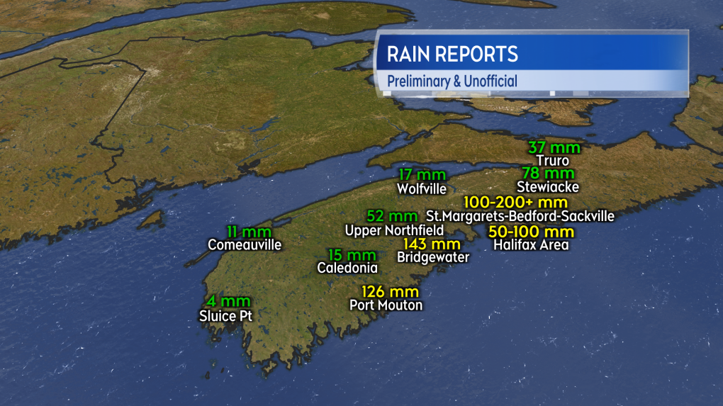
The slow-moving severe weather hammered many communities from near Port Mouton to Fall River with several rounds of torrential rain. Flooding and flash flooding occurred in some areas as people in some communities reported rain totals of more than 100 millimetres. Official rainfall totals are not yet available.
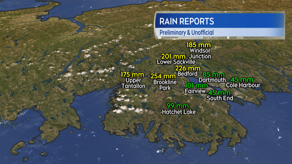
 Personal weather stations around Bedford and Sackville reported totals exceeding 200 millimetres of rain in just several hours.
Along with communities on the south shore, some suburbs in the Halifax Regional Municipality (HRM) were hit particularly hard by the storm. Personal weather stations in the vicinity of Bedford, Timberlea and Sackville reported rainfall totals exceeding 200 millimetres in seven hours. The extreme downpour flooded basements, yards, roads and highways. An emergency alert was issued for the HRM Friday evening advising residents to stay off roads unless it was an emergency.
 The most intense rain came in a band that extended up the south shore of Nova Scotia into the HRM.
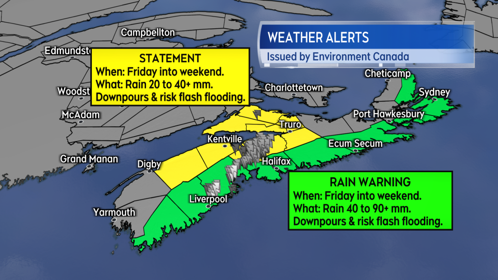
Rainfall warnings continue for the Atlantic coastal counties of mainland Nova Scotia, extending into Cape Breton with the exception of Inverness County, as of Friday night.
While areas of western Nova Scotia could still see additional rain on Saturday, the greatest risk of thunderstorms is expected to shift eastward on the weekend.

Saturday morning will see Halifax and eastern Nova Scotia with the greatest risk of additional severe weather. By Saturday afternoon, Guysborough County and the area to the east will have the greatest storm risk. Saturday night into Sunday morning will see the risk of thunderstorms linger for Cape Breton. Weather warnings for the eastern areas of Nova Scotia are calling for 40 to 80 millimetres of rain, however, locally, higher amounts are possible.
CTVNews.ca Top Stories

'It's a giant mess': Confusion remains about the GST/HST holiday
The organization representing small and medium size businesses in Canada says the start to the GST and HST holiday has been 'a giant mess.'
Donald Trump says Canada becoming 51st U.S. state is 'a great idea.' Jean Charest calls the comment a 'wake-up call'
U.S. President-elect Donald Trump is taking aim at Canada once more, saying it would be 'a great idea' to make it America's ‘51st state.'
'You're either with Beijing or you're with Washington': Ford says to Mexico in CNN interview
Ontario Premier Doug Ford has a message for Mexico as the threat of tariffs by incoming president Donald Trump hangs over both sides of the U.S. border.
There are 88 new Order of Canada appointees. Here's a look at some of the most notable names
Ryan Reynolds, Scott Oake and Maureen Ann Jennings are among the 88 new recipients of the Order of Canada.
NEW Here's how the cost of living challenges are shaking up Canadian seniors' retirement plans
With the high cost of living increasingly a concern, some seniors are making sacrifices to help their adult children and grandchildren make ends meet. Here are some of their stories.
Sikh separatist group accuses Russia of involvement in killing of B.C. activist
A Sikh separatist group is accusing the Russian government of direct involvement in the murder of activist Hardeep Singh Nijjar outside his gurdwara last year in Surrey, B.C.
'Why would I box myself in?: Singh on why he won't commit to helping bring Trudeau's gov't down, yet
NDP Leader Jagmeet Singh says U.S. president-elect Donald Trump's looming tariff threat is part of the reason why he's not committing to voting non-confidence in Prime Minister Justin Trudeau's government.
Iconic Halifax ship Theodore Too partially sunk at Ontario dock
An iconic ship that was a fixture in Halifax Harbour for 21 years has partially sunk in Ontario.
Oscars shortlist revealed. See which movies made the cut
A shortlist of Oscar contenders in ten categories has been revealed.


