Fierce storm brought hurricane force gusts and record-high temperatures to the Maritimes
The intense low pressure system that passed just to the west of the region brought with it winds that gusted well above 100 km/h for some areas, heavy rain, and some record-setting high temperatures.
Much of southern New Brunswick, almost all of Nova Scotia, and parts of Prince Edward Island reported gusts ranging 70 to near 110 km/h. A few areas reported hurricane force gusts, gusts of 120 km/h or higher, including Campobello Island, N.B., Brier Island, N.S., Kingsport, N.S., and northern Inverness County in Cape Breton. It should be noted, in a strong southerly wind, gusts reaching and exceeding 120 km/h in northern Inverness County aren’t all that uncommon due to enhancement of those winds by the Cape Breton Highlands.
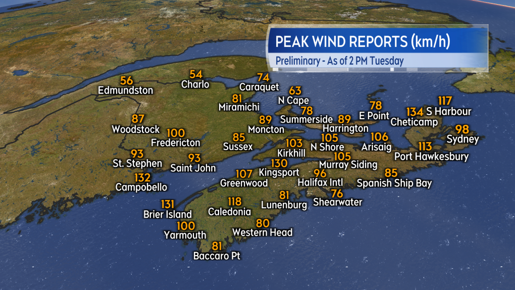 Peak wind reports from weather stations and volunteers around the Maritimes.
With the wind direction mostly from the south, the storm pulled warmer air up from the subtropical Atlantic. All three Maritimes provinces set new record highs for a Dec. 18. With temperature remaining very mild through Monday night, more record high temperatures were set for Dec. 19 on Tuesday.
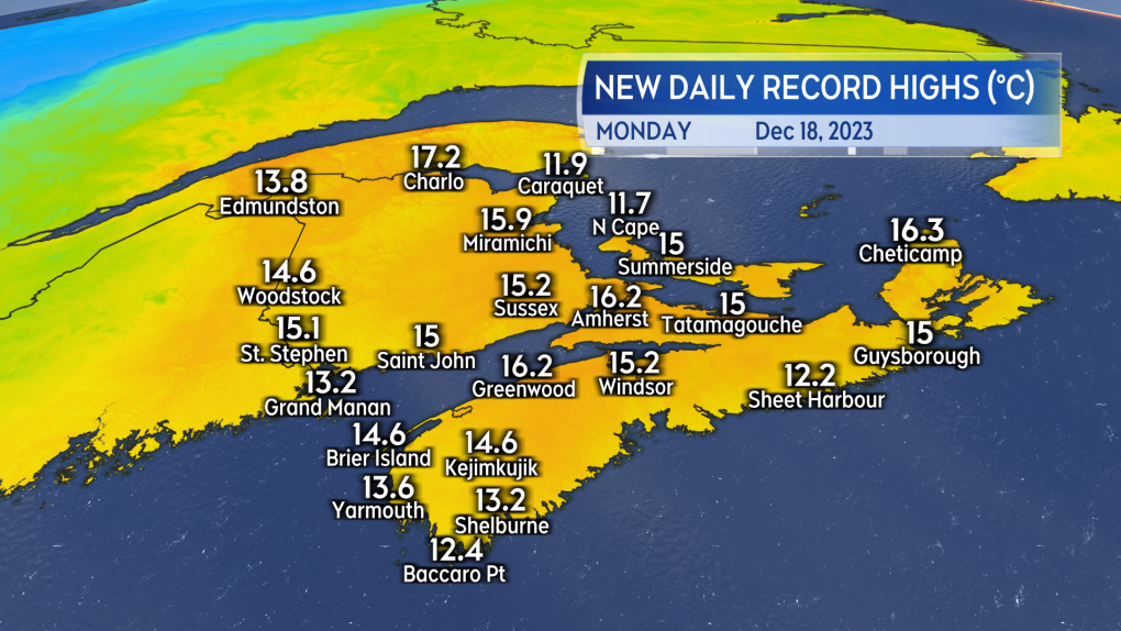 New high temperature records set for a December 18th in the Maritimes.
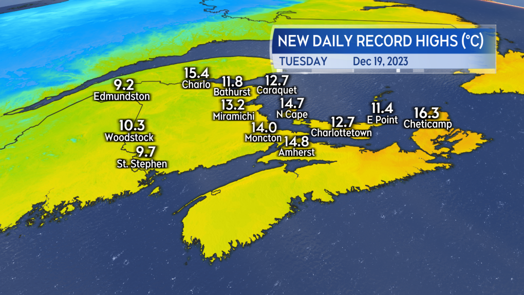 New high temperature records set for a December 19th in the Maritimes.
Heavy rain fell in New Brunswick and parts of Nova Scotia, with Prince Edward Island only receiving a light-to-moderate rainfall. The Fredericton area in New Brunswick reported rain totals near 50 mm and eastern areas of Nova Scotia have seen some rain amounts exceeding 50, 60, and even 70 mm. More rain is expected for that part of the Maritimes as a weather front has stalled out. The front continues to draw more moisture up from the subtropical Atlantic and bring it down as rain that could totals as much as another 100 millimetres for some communities by the time Thursday morning comes around. Rainfall Warnings continue for that part of Nova Scotia and caution on a risk of flooding and washouts.
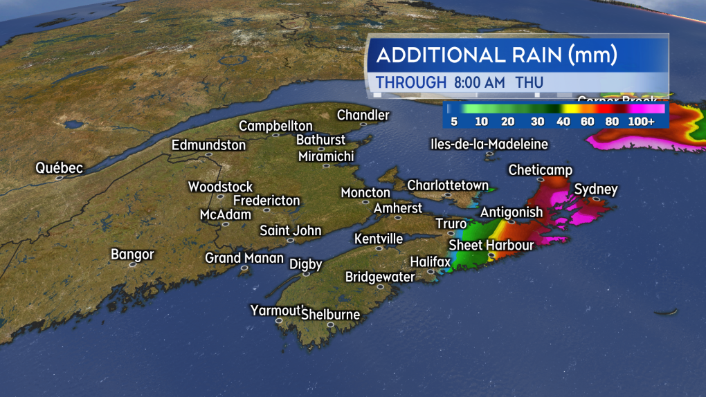 Another 50 to near 100 mm of rain are being indicated for parts of eastern Nova Scotia by Thursday morning.
The rain will start to exit east of Cape Breton through the day on Thursday. As chillier air returns into the back edge of that rain it may turn over to a period of snow Thursday afternoon into Friday. Environment Canada has a Special Weather Statement in place for Pictou, Antigonish, Guysborough, and Cape Breton advising that a “significant snowfall with strong northwesterly winds are likely” Thursday into Friday.
Shopping Trends
The Shopping Trends team is independent of the journalists at CTV News. We may earn a commission when you use our links to shop. Read about us.


CTVNews.ca Top Stories

Bird flu, measles top 2025 concerns for Canada's chief public health officer
As we enter 2025, Dr. Theresa Tam has her eye on H5N1 bird flu, an emerging virus that had its first human case in Canada this year.
Christmas shooting at Phoenix airport leaves 3 people wounded
Police are investigating a Christmas shooting at Sky Harbor Airport in Phoenix that left three people injured by gunfire.
Your kid is spending too much time on their phone. Here's what to do about it
Wondering what your teen is up to when you're not around? They are likely on YouTube, TikTok, Instagram or Snapchat, according to a new report.
6,000 inmates stage Christmas Day escape from high-security Mozambique prison
At least 6,000 inmates escaped from a high-security prison in Mozambique's capital on Christmas Day after a rebellion, the country's police chief said, as widespread post-election riots and violence continue to engulf the country.
Azerbaijan observes day of mourning for air crash victims as speculation mount about its cause
Azerbaijan on Thursday observed a nationwide day of mourning for the victims of the plane crash that killed 38 people and left all 29 survivors injured as speculation mounted about a possible cause of the disaster, with some experts saying that the airliner was damaged by Russian air defence fire.
Plush toys recalled due to choking hazard
Health Canada announced a recall on a series of plush toys due to a choking hazard. Anyone who has purchased an elephant, giraffe, lion, tiger and/or panda plush toy with an attached baby can return them to the place of purchase for a refund.
Donald Trump says he urged Wayne Gretzky to run for prime minister in Christmas visit
U.S. president-elect Donald Trump says he told Canadian hockey legend Wayne Gretzky he should run for prime minister during a Christmas visit but adds that the athlete declined interest in politics.
Prayers and tears mark 20 years since the Indian Ocean tsunami that killed some 230,000 people
People gathered in prayer and visited mass graves in Indonesia’s Aceh province on Thursday to mark 20 years since the massive Indian Ocean tsunami hit the region in one of modern history’s worst natural disasters.
New York taxi driver hits 6 pedestrians, 3 taken to hospital, police say
A taxicab hit six pedestrians in midtown Manhattan on Wednesday, police said, with three people — including a 9-year-old boy — transported to hospitals for their injuries.
Toronto
-

Boxing Day bargain hunters hit GTA stores in search of deals
Deal hunters are hitting stores around the GTA today to try take advantage of Boxing Day bargains and a tax holiday that offers further discounts.
-
Man wanted for 2 unprovoked incidents in downtown Toronto on Christmas Eve
Toronto police are searching for a suspect who allegedly choked a female in downtown Toronto then threatened an employee at a business with a hammer.
-
1 person seriously injured in Scarborough stabbing
One person was taken to the hospital with serious, but non-life-threatening injuries following a stabbing on Dec. 25 in Scarborough, say paramedics.
Calgary
-

Naheed Nenshi finding his feet leading an Alberta NDP still under construction
Nenshi finding his feet leading an Alberta NDP still under construction
-
Bird flu, measles top 2025 concerns for Canada's chief public health officer
As we enter 2025, Dr. Theresa Tam has her eye on H5N1 bird flu, an emerging virus that had its first human case in Canada this year.
-
Solar burgers: How agrivoltaics is marrying food production with green energy
Jason Bradley spent 20 years of his career as ranch manager at a 50,000-acre grazing operation in west-central Alberta, so he understands why people react with skepticism to the idea of raising a herd of cattle on a working solar farm.
Edmonton
-

Alberta premier hopes for health reform payoff in 2025, regrets deferring tax cut
"It may have been better for Albertans if we'd implemented and then found a way to be able to pay for it."
-
Naheed Nenshi finding his feet leading an Alberta NDP still under construction
Nenshi finding his feet leading an Alberta NDP still under construction
-
Donald Trump says he urged Wayne Gretzky to run for prime minister in Christmas visit
U.S. president-elect Donald Trump says he told Canadian hockey legend Wayne Gretzky he should run for prime minister during a Christmas visit but adds that the athlete declined interest in politics.
Montreal
-
 WEATHER
WEATHER Smog warning in effect in Montreal, Laval
Residents of Montreal, Laval and other regions are advised that a smog warning is in effect.
-
Ho! Ho! HOLY that's cold! Montreal boogie boarder in Santa suit hits St. Lawrence waters
Montreal body surfer Carlos Hebert-Plante boogie boards all year round, and donned a Santa Claus suit to hit the water on Christmas Day in -14 degree Celsius weather.
-
Ship remains stalled on St-Lawrence River north of Montreal
A ship that lost power on the St. Lawrence River on Christmas Eve, remains stationary north of Montreal.
Ottawa
-

Ottawa G1 driver caught driving uninsured, unaccompanied with out-of-service plate on HWY 417
A G1 driver is facing multiple charges after being stopped on Highway 417 in Ottawa for out-of-service licence plate Wednesday, according to the Ontario Provincial Police (OPP).
-
YEAR-IN-REVIEW
YEAR-IN-REVIEW Top stories in Ottawa in 2024
It was a year of change in Ottawa in 2024, with federal public servants required to spend more time in the office, alcohol now available in grocery stores and gas stations, and the Ottawa Senators taking the next step towards moving downtown.
-
What's open and closed in Ottawa over the holidays
CTVNewsOttawa.ca takes a look at what's open and closed over the Christmas and New Year's holidays this year.
London
-

Palace Theatre boarded up over the holidays due to recent damage
A break in, theft, and continued property damage has led to the boarding up of the Palace Theatre over the Christmas holidays.
-
Knights stars ready to help Canada chase gold at World Juniors
Three London Knights are on the roster, including Easton Cowan, who scored a hat-trick in Canada’s first exhibition game.
-
London fire responds to Wellington Road collision, contains fuel leak
London Fire Department was on the scene of a two vehicle collision involving a delivery truck on Tuesday morning.
Barrie
-

Here's when Santa is coming down your chimney, live tracking underway in Simcoe County
The spirit of Christmas is in the air as Santa Claus begins his lasting journey to deliver presents to children around the region.
-
Help this missing pup make it home for Christmas
The Ontario SPCA in Barrie needs your help bringing this handsome pup home to his family before Christmas.
-
Last minute shoppers braced for chaos but found calm on Christmas Eve
Many shoppers were out on Christmas Eve, and while the rush was expected to be chaotic, many found the day surprisingly manageable.
Northern Ontario
-
Bird flu, measles top 2025 concerns for Canada's chief public health officer
As we enter 2025, Dr. Theresa Tam has her eye on H5N1 bird flu, an emerging virus that had its first human case in Canada this year.
-
Indigenous family faced discrimination in North Bay, Ont., when they were kicked off transit bus
Ontario's Human Rights Tribunal has awarded members of an Indigenous family in North Bay $15,000 each after it ruled they were victims of discrimination.
-
Your kid is spending too much time on their phone. Here's what to do about it
Wondering what your teen is up to when you're not around? They are likely on YouTube, TikTok, Instagram or Snapchat, according to a new report.
Kitchener
-

Marking the start of Hanukkah in Guelph and Waterloo Region
People across Guelph and Waterloo Region are celebrating the start of Hanukkah.
-
Boxing Day bargain hunters hit GTA stores in search of deals
Deal hunters are hitting stores around the GTA today to try take advantage of Boxing Day bargains and a tax holiday that offers further discounts.
-
Donald Trump says he urged Wayne Gretzky to run for prime minister in Christmas visit
U.S. president-elect Donald Trump says he told Canadian hockey legend Wayne Gretzky he should run for prime minister during a Christmas visit but adds that the athlete declined interest in politics.
Windsor
-

Mother-daughter duo pursuing university dreams at the same time
For one University of Windsor student, what is typically a chance to gain independence from her parents has become a chance to spend more time with her biggest cheerleader — her mom.
-
VIDEO
VIDEO From a repaired stuffed animal to an ATV, shoppers reveal the best gift they have ever received
We asked people of all ages getting in some last-minute Christmas Eve shopping inside Windsor’s Devonshire Mall to talk about the best present they've ever received — and their answers might just warm your heart this holiday season.
-
'We may have to look at other sensible locations': Where will Windsor’s new H4 be located?
The search for a site to house Windsor’s new Homelessness and Housing Help Hub (H4) is back underway after the city scrapped plans at 700 Wellington Avenue on Monday.
Winnipeg
-

'They gambled with trees': Cutting down trees resumes in Lemay Forest
The next chapter of the Lemay Forest saga has unfolded as the sounds of trees coming down could be heard Monday.
-
One person dead, another injured following Monday night house fire
One person has died and another is in unstable condition following a house fire Monday evening.
-
Winnipeg police investigating string of packages being stolen
The Winnipeg Police Service is investigating a string of package thefts in the Transcona area.
Regina
-

Pedestrian collision sends man to hospital with life-threatening injuries
One man has been sent to hospital with life-threatening injuries after he was struck by a vehicle in the early hours of Wednesday in Regina.
-
Here's what's open and what's closed in Regina this holiday season
Here's what residents can expect in terms of city services as Regina slides right into the Christmas holidays.
-
This miniature village is a Christmas tradition for one Regina family
A miniature Christmas village made of decorative houses and buildings has been slowly growing in a Regina home.
Saskatoon
-

IN PICTURES: CTV Saskatoon viewers send us their holiday photos
A living gallery of viewer-submitted photos from the holiday season. Share your pictures with us at SaskatoonNews@bellmedia.ca
-
Sask. highway closed following serious collision
The Saskatchewan RCMP are investigating a serious collision on Highway 7, approximately 15 kilometres west of Rosetown.
-
'People prop the doors open': Saskatoon resident concerned as people shelter in her stairwell
With the number of homeless people in Saskatoon at an unprecedented high, it’s no surprise people are looking for places to warm up.
Vancouver
-

Thousands without power on Christmas as winds, rain continue in B.C. coastal areas
Thousands of people in British Columbia are without power on Christmas Day as ongoing rainfall and strong winds collapse power lines, disrupt travel and toss around holiday decorations.
-
Passenger dead following pickup truck crash in Surrey, B.C.
A section of B.C.’s Highway 15 has closed following a crash that killed a person Christmas Day.
-
Homegrown gift-giving initiative makes Christmas morning magic for families in need
On Christmas morning, hundreds of families throughout the Lower Mainland who otherwise might not have had anything to open were given sackfuls of brightly wrapped gifts to unwrap with their families, courtesy of a grassroots charity ran by one Surrey woman.
Vancouver Island
-

BC Ferries cancels many Christmas Day sailings, says others 'at risk'
The stormy weather in the forecast for B.C.'s South Coast is already disrupting many Christmas Day travel plans.
-
Janitors at Vancouver airport ratify deal with employer, end strike
The janitors who clean the Vancouver International Airport have ratified a new collective agreement with their employer, ending their strike on Christmas Eve.
-
Gas leaking after truck crash in Port Moody not ammonia, police say
There were tense moments for first responders in Port Moody on Christmas Eve, after a commercial truck crashed and began leaking gas.
Kelowna
-

Forfeited Hells Angels clubhouse in Kelowna, B.C., sold to the city
A former Hells Angels clubhouse that was seized by the British Columbia government in 2023 after years of fighting in court has been sold to the City of Kelowna.
-
Death of woman found in Kelowna's Waterfront Park in June deemed 'non-criminal in nature': RCMP
Police in Kelowna say a death they began investigating back in June has now been confirmed as "non-criminal in nature."
-
B.C. man sentenced for 'execution-style' murder of bystander in drug trade conflict
A B.C. man convicted of the "intentional and ruthless killing of a bystander" while acting as an enforcer in the drug trade has been sentenced for a second time in the slaying.


