Fire danger remains high as hot, dry week expected for Maritimes
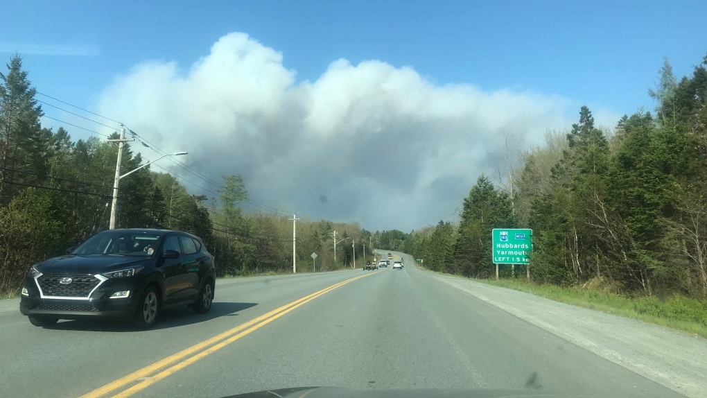
 The Upper Tantallon area fire is seen in this May 28, 2023, photo. (Sarah Plowman/CTV Atlantic)
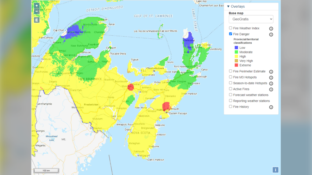
Natural Resources Canada still has much of the Maritimes rated with a “high” fire danger index to start this week.
Pockets of northern New Brunswick, eastern P.E.I., and eastern Nova Scotia have a “moderate” fire rating.
 Fire danger ratings for the Maritimes per Natural Resources Canada.
The region needs rain, but there is little in the forecast over the next several days.
High pressure building in from the west is expected to keep conditions dry Tuesday and Wednesday. There is a chance of showers and thunderstorms in the northern part of New Brunswick Thursday.
A weather front crossing the Maritimes on Friday brings with it the best chance of seeing widespread showers and possible pockets of rain.
Current guidance indicates that the wet weather Friday may only bring a few millimetres of rain to much of the Maritimes. Some pockets with more than 10 millimetres of rain are possible.
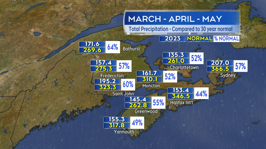
It has been a dry Spring, with precipitation totals for March and April well-below historic averages.
The Canadian Drought Monitor has most of Nova Scotia, southern New Brunswick, and Prince Edward Island in abnormally dry to moderate drought conditions.
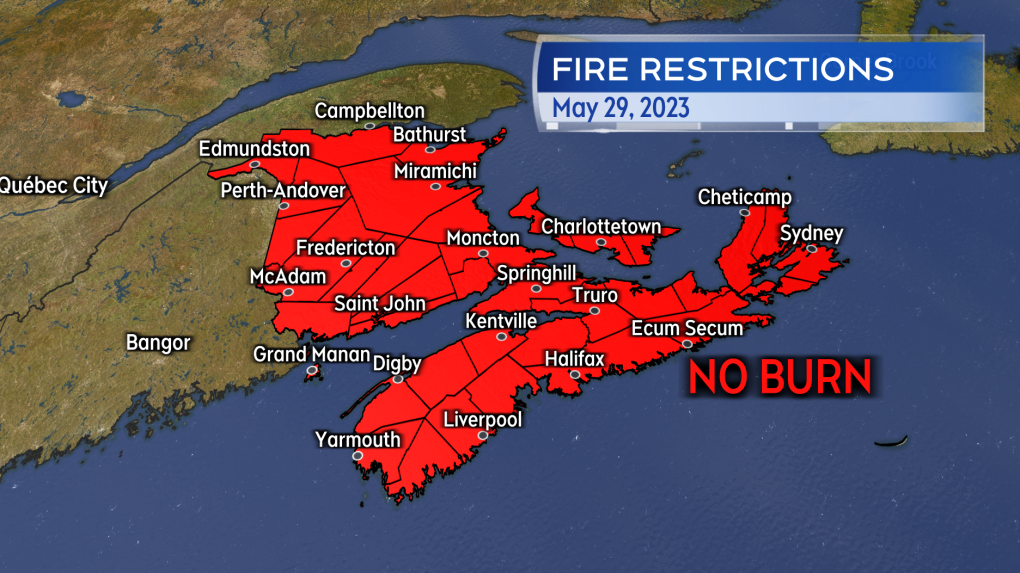
All three Maritime provinces are under a burn ban.
 A no burn order is in effect for all three Maritime provinces. More hot and dry weather is forecast this week.
Sunday was hot, with record high temperatures set in all three Maritimes provinces. Moncton, N.B., hit a record high of 31.8 C, Halifax Airport hit a record of 31.4 C, and Charlottetown P.E.I. hit a record of 28.3 C. It was the hottest day of the year so far.
More unseasonably hot temperatures are expected Wednesday and Thursday this week, with hhighs in the upper 20s C and low 30s C. Parts of the coast exposed to winds off ocean waters will be a bit cooler.
 Total precipitation compared to the 30 year average for the months of March, April, and May combined.
Temperatures are forecast to cool on Friday with the forecasted arrival of widespread cloud and showers, as well as a turn to a northerly wind.
CTVNews.ca Top Stories

What is flagpoling? A new ban on the practice is starting to take effect
Immigration measures announced as part of Canada's border response to president-elect Donald Trump's 25 per cent tariff threat are starting to be implemented, beginning with a ban on what's known as 'flagpoling.'
Hong Kong police issue arrest warrants and bounties for six activists including two Canadians
Hong Kong police on Tuesday announced a fresh round of arrest warrants for six activists based overseas, with bounties set at $1 million Hong Kong dollars for information leading to their arrests.
Stunning photos show lava erupting from Hawaii's Kilauea volcano
One of the world's most active volcanoes spewed lava into the air for a second straight day on Tuesday.
Indigenous family faced discrimination in North Bay, Ont., when they were kicked off transit bus
Ontario's Human Rights Tribunal has awarded members of an Indigenous family in North Bay $15,000 each after it ruled they were victims of discrimination.
Heavy travel day starts with brief grounding of all American Airlines flights
American Airlines briefly grounded flights nationwide Tuesday because of a technical problem just as the Christmas travel season kicked into overdrive and winter weather threatened more potential problems for those planning to fly or drive.
OPP and Ottawa firefighters help remove vehicle wedged into Highway 417 overpass
Ottawa firefighters and local Ontario Provincial Police officers were called to a bizarre scene Tuesday morning along Highway 417, where a driver managed to wedge his vehicle under an overpass.
On Christmas Eve, Pope Francis appeals for courage to better the world
Pope Francis said the story of Jesus' birth as a poor carpenter's son should instill hope that all people can make an impact on the world, as the pontiff on Tuesday led the world's Roman Catholics into Christmas.
Read Trudeau's Christmas message
Prime Minister Justin Trudeau issued his Christmas message on Tuesday. Here is his message in full.
Ontario First Nation challenging selection of underground nuclear waste site in court
A First Nation in northern Ontario is challenging the selection of a nearby region as the site of a deep geological repository that will hold Canada's nuclear waste, arguing in a court filing that it should have had a say in the matter as the site falls "squarely" within its territory.


