Friday snow reports and storm set to arrive Monday for the Maritimes

As of Saturday morning, widespread snow totals of 10 to 25 cm have been reported in Nova Scotia from our latest weather system.
Reports of 5 to 10 cm across southern New Brunswick and 5 to 10 cm across Prince Edward Island except a few reports a bit higher than 10 cm in Kings County.
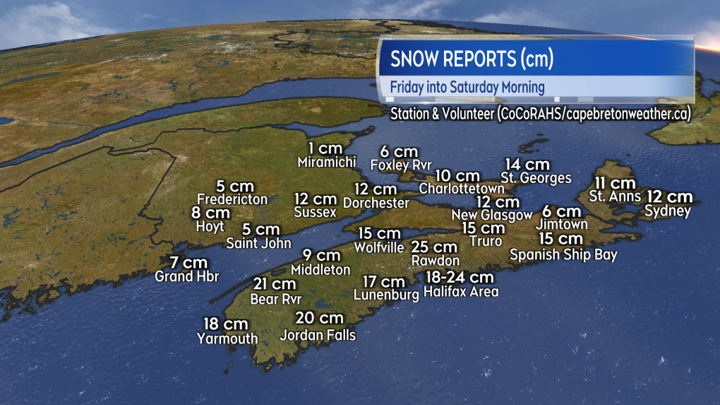 Station and volunteer snow reports from the latest system to impact the Maritimes.
Now we're turning our attention to a storm system that will travel from Cape Cod across Nova Scotia on Monday.
Special Weather Statements have been issued by Environment Canada for Nova Scotia, Prince Edward Island, and southern-central New Brunswick.
In Nova Scotia, the statements caution that snow will turn over to heavy rain and strong winds on Monday. Additionally they mention that "a run of high tides combined with high waves approaching from the south may give coastal flooding conditions for southwestern Nova Scotia late Monday morning."
For New Brunswick the statements call for the potential of heavy snow that could total over 25 cm in some areas.
A turn to rain near the Bay of Fundy coastline is likely to lead to lower totals there. Additionally, northern areas of the province are currently only expected to receive a lighter snowfall.
The statement for Prince Edward Island forecasts heavy snow to start before eastern and central areas of the province turn over to rain. The highest snowfall amounts are expected in western parts of the province where they could reach more than 25 cm.
All three Maritimes provinces are advised to continue to monitor the forecast as weather warnings are likely to be issued.
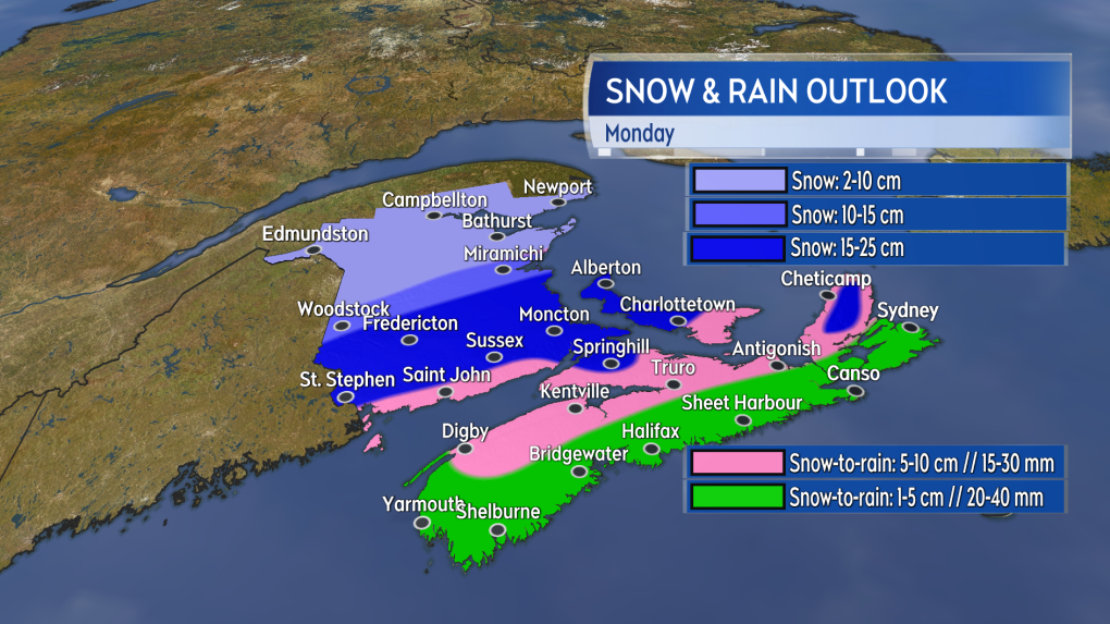 A mix of heavy snow and heavy rain is expected in the Maritimes on Monday.
Snow is expected to reach western New Brunswick and southwestern Nova Scotia as early as Sunday night.
Snow turning to rain develops across Nova Scotia early Monday morning. Snow spreads across southern-central New Brunswick and Prince Edward Island Monday morning.
The inclement weather conditions will continue into Monday evening before mostly clearing overnight into early Tuesday morning. A round of snow on the back edge of the system may linger for Cape Breton into Tuesday morning.
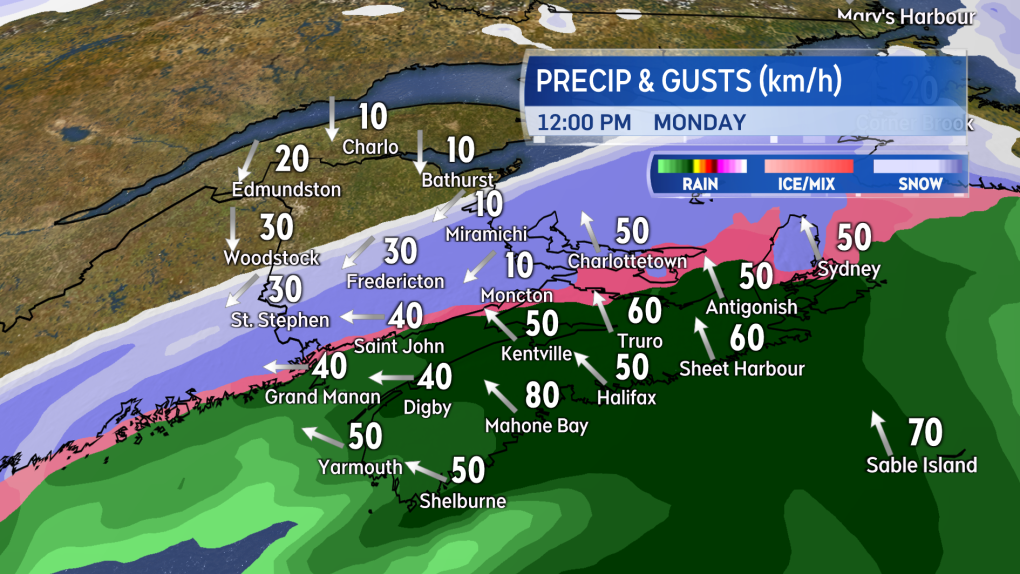 A mix of snow and rain will develop across the Maritimes early Monday morning.
A gusty southerly wind will accompany the mix of precipitation for much of the Maritimes.
Widespread gusts of 30 to 60 km/h with peak gusts on exposed areas of the Atlantic coastline of Nova Scotia reaching 60 to 80 km/h. Due to the topography of the Highlands gusts in northern Inverness County, Cape Breton could peak at 100+ km/h.
More to come.
Shopping Trends
The Shopping Trends team is independent of the journalists at CTV News. We may earn a commission when you use our links to shop. Read about us.


CTVNews.ca Top Stories

Calgary woman stranded in Mexico after husband's death during diving trip
A Calgary woman is struggling to return home after her husband died while diving in Mexico, leaving her stranded and facing financial hardship.
CBSA increases travel cost reimbursement fees for 'inadmissible' foreign nationals
Foreign nationals who refuse or are unable to pay their own way home after being denied stay in Canada will soon face steeper financial penalties should they ever attempt to return.
Sea and Himalayan salts recalled in Canada: 'Do not use, serve or distribute'
Two brands of sea and Himalayan salt are being recalled in Canada due to pieces of plastic found in the products.
Liberal caucus chairs meet to talk Trudeau, PM attends Canada-U.S. cabinet committee
Prime Minister Justin Trudeau was back in Ottawa today, but having yet to signal he's ready to address the snowballing resignation calls, the Liberal caucus' regional chairs called a meeting today to discuss next steps.
N.S. community shocked by deaths of father, daughter; suspect was wanted in Toronto shooting
A Nova Scotia community is mourning the loss of two of its members after they were shot and killed in Halifax on New Year’s Eve.
Judge sets Trump's sentencing in hush money case for Jan. 10, but signals no jail time
In an extraordinary turn, a judge Friday set U.S. president-elect Donald Trump's sentencing in his hush money case for Jan. 10, but indicated he wouldn't be jailed.
'Mystery volcano' that erupted and cooled Earth in 1831 has finally been identified
An unknown volcano erupted so explosively in 1831 that it cooled Earth's climate. Now, nearly 200 years later, scientists have identified the 'mystery volcano.'
When do I receive federal benefits this year? Payment dates for 2025
From the Canada Child Benefit to Old Age Security, federal payment dates have been determined for 2025. Find out when you can expect your payments.
Ontario aiming to send out $200 rebate cheques later this month or early February
Ontarians should receive their $200 rebate cheque from the province by the end of January or early February, a government spokesperson confirmed in an email Friday.
Toronto
-

Union representing Ontario college faculty issues five-day strike notice
Ontario college students could soon see their winter semester cut short as the union representing faculty at the province’s 24 public colleges could walk off the job as early as Thursday next week.
-
Ontario aiming to send out $200 rebate cheques later this month or early February
Ontarians should receive their $200 rebate cheque from the province by the end of January or early February, a government spokesperson confirmed in an email Friday.
-
Sea and Himalayan salts recalled in Canada: 'Do not use, serve or distribute'
Two brands of sea and Himalayan salt are being recalled in Canada due to pieces of plastic found in the products.
Calgary
-
Calgary woman stranded in Mexico after husband's death during diving trip
A Calgary woman is struggling to return home after her husband died while diving in Mexico, leaving her stranded and facing financial hardship.
-
Calgary police seek driver of 'red vehicle' wanted in serious hit-and-run on Memorial Drive
Calgary police are hoping to gain more information from the public on a hit-and-run in November that badly injured one person.
-
5,600 Olympic Plaza bricks were saved, being returned to those who purchased them
The City of Calgary is in the process of giving back thousands of bricks saved from Olympic Plaza ahead of the aging infrastructure's overhaul.
Edmonton
-

Homicide investigation underway after woman found dead on Edmonton riverbank
Police have identified a woman who was recently found dead on the shore of the North Saskatchewan River in Edmonton.
-
Nenshi announces run for Edmonton-Strathcona seat to 'go head-to-head' with Smith
New Alberta NDP Leader Naheed Nenshi says he is aiming to join the legislature to "go head-to-head" with Premier Danielle Smith.
-
Police seize weapons, illegal tobacco from central Edmonton convenience store
Three people have been charged after police seized illegal weapons and tobacco from a downtown convenience store.
Montreal
-

More homeless people hiding from the cold in Montreal's crowded ERs
When warming centres are full, homeless people with nowhere to go are turning to emergency rooms.
-
Montreal police make 2 more arrests in killing of Claudia Iacono
Montreal police have arrested two more suspects in the slaying of Claudia Iacono.
-
Quebec man, 53, stole salt truck, climbed tree to evade arrest after hourslong pursuit: police
Quebec provincial police say a man led officers on a wild police chase spanning about 70 kilometres that started with a stolen salt truck and ended with the suspect climbing a tree to evade arrest.
Ottawa
-

Highrise fire on Ramsey Crescent displaces 39 residents
The Ottawa Paramedic Service says four adult women were taken to hospital following a fire that happened in a highrise on Ramsey Crescent, in the west end of Ottawa, in the early hours of Friday morning.
-
Man, woman seriously injured following multi-vehicle collision on Bank Street
A man and a woman were seriously injured following a multi-vehicle collision on Bank Street at Lester Road Friday afternoon, according to the Ottawa Paramedic Service.
-
OTTAWA'S LRT
OTTAWA'S LRT All aboard Ottawa's new LRT line: What you need to know about the new north-south Line 2 and Line 4
Ottawa’s new north-south rail line will open to the public on Monday, Jan. 6, connecting downtown Ottawa and Riverside South with a spur to the Ottawa International Airport.
London
-

Guerra Guerra found guilty of second-degree murder in bush party case
Carlos Guerra Guerra has been found guilty of second-degree murder in the 2021 bush party murder trial.
-
Road conditions deteriorate in areas north of London
Several areas in midwestern Ontario have had a snow squall watch upgraded to a snow squall warning.
-
College faculty could walk off the job as of January 9
Following months of anticipation, discussion, and bargaining, the Ontario Public Service Employees Union (OPSEU) is one step closer to walking off the job.
Barrie
-

King Twp. man wanted for an alleged attempted murder
Police are searching for a man they believe is armed and dangerous.
-
Fail-to-remain driver busted hours after collision
A Cambridge man was busted in Caledon for a Brampton collision.
-
Blue Mountains ski shop a cornerstone of the community for nearly 60 years
For nearly 60 years, Squire John’s has been a cornerstone of the community, combining a love for the outdoors with a commitment to customer care in the Town of the Blue Mountains.
Northern Ontario
-

Suspect charged in northern Ont. road rage incident that went viral
A 37-year-old suspect has been charged in connection with a road rage incident last week in Temiskaming Shores.
-
Union representing Ontario college faculty issues five-day strike notice
Ontario college students could soon see their winter semester cut short as the union representing faculty at the province’s 24 public colleges could walk off the job as early as Thursday next week.
-
Sault, Ont., man claims Indigenous moose hunting rights without proof, fined $5,500
A hunter from Sault Ste. Marie, Ont., has been fined for moose hunting without a licence or proper documentation. He claimed Indigenous hunting rights but failed to provide any proof.
Kitchener
-

Snow squall warnings for southwestern Ontario
Environment Canada says southwestern Ontario could get between 15 and 60 centimetres of snow by Saturday.
-
Transit fares going up in Guelph and Waterloo Region
Taking public transit in Guelph and Waterloo Region is going to be a little more costly in 2025.
-
More than 30 bottles of scotch and tequila stolen from Guelph business
The Guelph Police Service is investigating after three people made off with $2,700 worth of alcohol from a business on Thursday.
Windsor
-

2.99% tax increase in proposed 2025 Windsor budget
The proposed 2025 City of Windsor budget includes a 2.99 per cent tax increase.
-
-
'It was a privilege to work alongside him': Habitat for Humanity Windsor-Essex joins worldwide memorial for Jimmy Carter
Habitat for Humanity Windsor-Essex is joining a worldwide memorial for late U.S. President Jimmy Carter.
Winnipeg
-

Extreme cold warning takes over Manitoba
An extreme cold warning has been issued for the majority of Manitoba as the wind chill could hit near -40 or colder.
-
Proposed Winnipeg Costco could be growing in size
The footprint for the new Costco planned in Winnipeg could be growing.
-
Man jumps from moving vehicle to escape robbery of high-end shoes: Winnipeg police
Two men from Saskatchewan have been charged after another man had to leap from a moving vehicle during an attempted robbery.
Regina
-

Sask. RCMP investigating woman's death on Piapot First Nation
Saskatchewan RCMP says it is investigating the death of a 30-year-old woman on Piapot First Nation as suspicious in nature.
-
CTV Regina's top trending stories of 2024
Whether it was hard news or light-hearted features, the year of 2024 hosted some very compelling stories – with several being widely shared online and reaching new audiences.
-
Charges stayed for Saskatchewan officer accused of negligence after in-custody death
Charges have been dropped against Saskatchewan police officer accused of negligence in the death of a man in custody.
Saskatoon
-

Inmate who escaped federal prison in Saskatchewan arrested
After about five months of searching, police have arrested Jareth Gardipy-Taypotat, who escaped from the Willow Cree Healing Lodge, a minimum-security federal institution north of Saskatoon.
-
Charges stayed for Saskatchewan officer accused of negligence after in-custody death
Charges have been dropped against Saskatchewan police officer accused of negligence in the death of a man in custody.
-
Saskatoon police investigating stabbing incidents that left 3 men seriously injured
Saskatoon police are investigating multiple stabbing incidents that left three men seriously injured.
Vancouver
-

B.C. driver who tried to apprehend suspected impaired driver was impaired: RCMP
Mounties on Vancouver Island say a 50-year-old motorist who tried to apprehend a suspected impaired driver on New Year's Eve, was, in fact, impaired and was issued a 90-day driving prohibition by police.
-
A parking spot in Whistler, B.C., could be yours for $110K
Any skiers looking to avoid circling the parking lots at the world-famous Whistler Blackcomb resort can now solve that problem—but it comes with a six-figure price tag.
-
Prince George RCMP seek witnesses after B.C. Highway 97 weigh scales blaze
Police in Prince George, B.C., are investigating an arson at the weigh scale facility on Highway 97, and are calling on the public for assistance.
Vancouver Island
-
B.C. driver who tried to apprehend suspected impaired driver was impaired: RCMP
Mounties on Vancouver Island say a 50-year-old motorist who tried to apprehend a suspected impaired driver on New Year's Eve, was, in fact, impaired and was issued a 90-day driving prohibition by police.
-
Woman, 63, dead after collision on Vancouver Island
A 63-year-old woman is dead after the car she was driving collided with a truck on southern Vancouver Island.
-
Museum of whale skeletons, painstakingly rebuilt over years, consumed by B.C. fire
It takes years to rebuild a whale. Just ask Jim Borrowman, co-founder of the Whale Interpretive Centre museum that housed numerous whale skeletons on the boardwalk of Telegraph Cove on Vancouver Island.
Kelowna
-

Charges laid after child porn investigation that 'spanned several different countries,' Kelowna RCMP say
Police in Kelowna say an international investigation has led to child pornography charges against a 46-year-old man.
-
Mounties investigate discovery of 'very small pipe bomb' in Kamloops, B.C.
Mounties are investigating and appealing for witnesses after an explosive device was discovered Wednesday on a beach in Kamloops, B.C.
-
Kamloops couple delivers B.C.'s first baby of 2025
B.C.'s first baby of 2025 was born just after midnight at Royal Inland Hospital in Kamloops.


