Here is where the most rain will fall in the Maritimes on Saturday
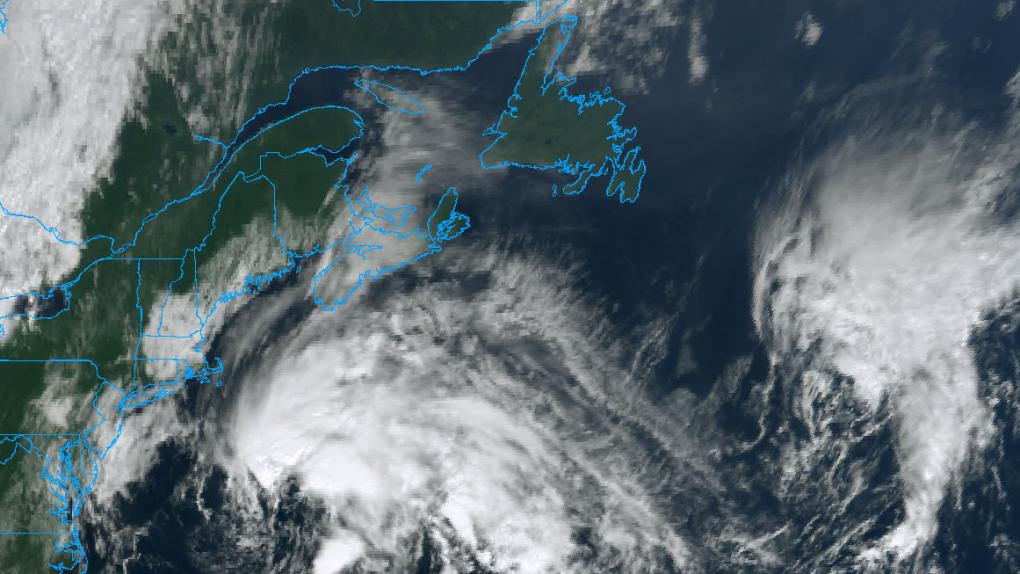 A low-pressure system containing tropical levels of moisture is approaching the Maritimes from the south.
A low-pressure system containing moisture drawn up from the subtropical Atlantic will bring heavy rain and gusty winds to parts of the Maritimes Friday night and Saturday.
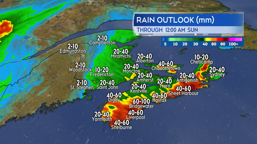
Heavy rain
Due to the system having some tropical characteristics, some of the rain will come in the form of downpours.
Nova Scotia looks most at risk for downpours with rainfall warnings issued by Environment Canada calling for rain rates that could approach 25 mm/hr. I’ve found that the risk of localized flash flooding increases in that province when rain rates reach 20+ mm/hr.
The most widespread rain totals of 50 to 100 mm fare for Halifax County and the South Shore of Nova Scotia. A bullseye of 80 to near 100 mm are showing in the area between Liverpool and Bridgewater. Pockets of rain totals reaching 50 to 80 mm are also being indicated for Guysborough County, mainland Nova Scotia and Victoria County, Cape Breton. Those areas are currently under a special weather statement.
Parts of southern and eastern areas of New Brunswick as well as Prince Edward Island will largely see rain totals of 20 to 40 mm. There is a risk of localized downpours for those areas. In the event a downpour or two moves directly through a given community, localized rain totals could reach 50+ mm. That area of the Maritimes remains under a special weather statement as of noon Friday.
Most of the rain falls Saturday morning through Saturday afternoon.
 The most widespread, heavy rain is expected in the province of Nova Scotia.
High wind
Peak easterly wind gusts of 70 to 90 km/h will develop for areas of the Atlantic coastline of Nova Scotia exposed to the east on Saturday morning. Gusts away from the coastline will reach 40 to 60 km/h. Due to the topography of the Cape Breton Highlands, gusts in northern Inverness County will reach 100+ km/h Saturday afternoon.
New Brunswick will mostly top out with gusts of 30 to 50 km/h. Peak gusts of 50 to 70 km/h will be possible in and on the Bay of Fundy coastline Saturday morning.
P.E.I. and the Magdalen Islands will see peak gusts of 50 to 70 km/h late Saturday morning and Saturday afternoon.
No wind warnings were in effect as of noon Friday. Environment Canada is cautioning that some scattered utility outages are possible in the rainfall warnings and special weather statements. Wind will diminish Saturday evening and night across the Maritimes.
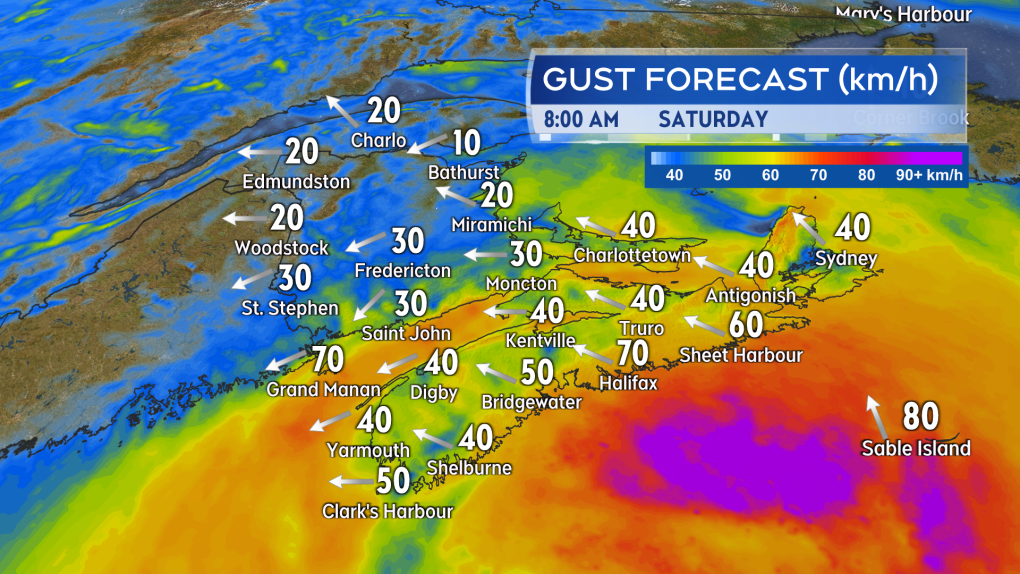 A gusty, easterly wind will accompany the rain. Gusts will generally be strongest on areas of the coast exposed to the east as well as at higher terrain.
Sunday showers
A second, separate weather front from the west moves across the Maritimes on Sunday.
That weather system is expected to bring the region scattered, intermittent showers to close the weekend.
Additional rain amounts in the showers should be mostly held in the range of two-to-10 mm.
Shopping Trends
The Shopping Trends team is independent of the journalists at CTV News. We may earn a commission when you use our links to shop. Read about us.


CTVNews.ca Top Stories

Trudeau's 2024: Did the PM become less popular this year?
Justin Trudeau’s numbers have been relatively steady this calendar year, but they've also been at their worst, according to tracking data from CTV News pollster Nik Nanos.
Manhunt underway after woman, 23, allegedly kidnapped, found alive in river
A woman in her 20s who was possibly abducted by her ex is in hospital after the car she was in plunged into the Richelieu River.
Death toll in attack on Christmas market in Germany rises to 5 and more than 200 injured
Germans on Saturday mourned both the victims and their shaken sense of security after a Saudi doctor intentionally drove into a Christmas market teeming with holiday shoppers, killing at least five people, including a small child, and wounding at least 200 others.
Overheated immigration system needed 'discipline' infusion: minister
An 'overheated' immigration system that admitted record numbers of newcomers to the country has harmed Canada's decades-old consensus on the benefits of immigration, Immigration Minister Marc Miller said, as he reflected on the changes in his department in a year-end interview.
Toronto firefighters rescue man who fell into sinkhole in Yorkville
A man who fell into a sinkhole in Yorkville on a snowy Friday night in Toronto has been rescued after being stuck in the ground for roughly half an hour.
Wild boar hybrid identified near Fort Macleod, Alta.
Acting on information, an investigation by the Municipal District of Willow Creek's Agricultural Services Board (ASB) found a small population of wild boar hybrids being farmed near Fort Macleod.
Summer McIntosh makes guest appearance in 'The Nutcracker'
Summer McIntosh made a splash during her guest appearance in The National Ballet of Canada’s production of 'The Nutcracker.'
The winter solstice is here, the Northern Hemisphere's darkest day
The winter solstice is Saturday, bringing the shortest day and longest night of the year to the Northern Hemisphere — ideal conditions for holiday lights and warm blankets.
22 people die in a crash between a passenger bus and a truck in Brazil
A crash between a passenger bus and a truck early Saturday killed 22 people on a highway in Minas Gerais, a state in southeastern Brazil, officials said.
Toronto
-

Homicide investigation underway in Toronto's Corso Italia neighbourhood
A homicide investigation is underway after a male who was found in Toronto’s Corso Italia neighbourhood early Saturday morning died in hospital, police say.
-
Toronto firefighters rescue man who fell into sinkhole in Yorkville
A man who fell into a sinkhole in Yorkville on a snowy Friday night in Toronto has been rescued after being stuck in the ground for roughly half an hour.
-
'It's about protecting Canadian content': Leading Canadian publishing house seeks solutions to expected rise in distribution costs
One of Canada’s leading publishing houses is worried that it may soon not be able to keep up with the rising costs of storing the hundreds of book titles it distributes, potentially impacting the availability of educational materials and trade books from coast to coast.
Calgary
-

Calgary non-profit Yes Youth Centre hands out hundreds of free turkeys in Forest Lawn
Turkeys were flying out the door at the “Yes Youth Centre” in Forest Lawn Friday morning.
-
It's eggnog season. The boozy beverage dates back to medieval England but remains a holiday hit
At Scoma's Restaurant in San Francisco, this holiday season 's batch of eggnog began 11 months ago.
-
Death toll in attack on Christmas market in Germany rises to 5 and more than 200 injured
Germans on Saturday mourned both the victims and their shaken sense of security after a Saudi doctor intentionally drove into a Christmas market teeming with holiday shoppers, killing at least five people, including a small child, and wounding at least 200 others.
Edmonton
-

Second inmate dies at Edmonton Remand Centre in as many days
An inmate died at the Edmonton Remand Centre on Thursday night.
-
It's eggnog season. The boozy beverage dates back to medieval England but remains a holiday hit
At Scoma's Restaurant in San Francisco, this holiday season 's batch of eggnog began 11 months ago.
-
Child pornography charges laid against 52-year-old woman
A Sherwood Park woman has been charged with two child pornography offences.
Montreal
-

Canada Post says many parcels held up by strike to arrive before Christmas
Canada Post says it has processed its backlog of parcels from the month-long strike and expects a significant portion of them to be delivered before Christmas.
-
Judge sentences Quebecer convicted of triple murder who shows 'no remorse'
A Quebecer convicted in a triple murder on Montreal's South Shore has been sentenced to life in prison without chance of parole for 20 years in the second-degree death of Synthia Bussieres.
-
Manhunt underway after woman, 23, allegedly kidnapped, found alive in river
A woman in her 20s who was possibly abducted by her ex is in hospital after the car she was in plunged into the Richelieu River.
Ottawa
-

Here’s how cold it feels in Ottawa this Saturday
The frigid temperatures are making a comeback in full force this Saturday, as it’s going to feel like minus 24 Saturday afternoon in Ottawa.
-
What's happening in Ottawa over the Christmas holidays
CTVNewsOttawa.ca looks at things to do in Ottawa over the holiday season.
-
'Hot and frosty': Film industry booming in Ottawa
Ottawa is not only a hot spot for tourism, but also a landmark when it comes to the film industry and holiday movies, says the City of Ottawa.
London
-

Exodus of new home construction to sprawling rural communities sparks new strategy to lower lot prices in London
City council is betting that a dramatic boost to the supply of residential land within the city limits will lower the price of lots in new subdivisions and slow the number of people moving to bedroom communities in Middlesex County and beyond.
-
Man dies after falling from building: LPS
London police say a man has died after falling from a building.
-
Fire destroys London Cricket Club memorabilia, equipment
A fire destroyed thousands of dollars worth of property and memorabilia at the London Cricket Club.
Barrie
-

Multi-vehicle collision on Highway 11 in Oro-Medonte
Southbound traffic along Highway 11 through Oro-Medonte was brought to a crawl Friday after a multi-vehicle collision.
-
High school teacher charged with sexual assault amid allegations involving a student
A 51-year-old teacher from Georgina has been charged with sexual assault following allegations involving a student.
-
Driver charged after vehicle crashes into Barrie home
A driver was arrested Thursday night after a vehicle crashed into a home in Barrie.
Northern Ontario
-
Trudeau's 2024: Did the PM become less popular this year?
Justin Trudeau’s numbers have been relatively steady this calendar year, but they've also been at their worst, according to tracking data from CTV News pollster Nik Nanos.
-
Northern Ont. man illegally killed three moose, one deer
A man from the northwestern Ontario community of Dinorwic has been found guilty of multiple hunting offences and fined $6,500, banned from hunting for five years and placed on probation for 18 months.
-
Poilievre writes to GG calling for House recall, confidence vote after Singh declares he's ready to bring Liberals down
Conservative Leader Pierre Poilievre has written to Gov. Gen. Mary Simon, imploring her to 'use your authority to inform the prime minister that he must' recall the House of Commons so a non-confidence vote can be held. This move comes in light of NDP Leader Jagmeet Singh publishing a letter stating his caucus 'will vote to bring this government down' sometime in 2025.
Kitchener
-

Guelph man pleads guilty to fleeing fatal crash involving cyclist
A Guelph driver, who previously admitted to failing to stop after a fatal crash, instead plead guilty to a different charge on Friday.
-
School custodian stages surprise for Kitchener, Ont. students ahead of holiday break
He’s no Elf on the Shelf, but maybe closer to Ward of the Board.
-
Distillers not feeling the 'tax holiday' spirit
While some shoppers and store owners are celebrating the HST 'tax holiday' from the federal government, not all industries are feeling the holiday spirit.
Windsor
-

Clear Medical Imaging strike ends with arbitration agreement
The eight-week long strike action at Clear Medical Imaging has ended. According to officials, Unifor and the employer have agreed to binding arbitration.
-
Leamington resident now $50,000 richer
Helio Ferrieria of Leamington is celebrating after winning an ONTARIO 49 second prize worth $50,000 in the Dec. 4, 2024, draw.
-
Over $45,000 in cash and drugs seized: WPS
Two suspects have been arrested and over $45,000 in cash and drugs seized following an investigation by the Windsor Police Service (WPS).
Winnipeg
-

Bail denied for Winnipeg woman accused of killing animals in online videos
Warning: This story contains disturbing details. Discretion is advised. A Winnipeg woman accused of making videos of animals being tortured and killed that were sold on the dark web was denied bail.
-
Man suffers broken leg after being arrested by Winnipeg police; IIU investigating
The Winnipeg Police Service said the Independent Investigation Unit of Manitoba is investigating after a man suffered broken bones in his leg after being arrested.
-
Ace Burpee's Top 100 Most Fascinating Manitobans of 2024
It’s been another year of Manitobans doing interesting, incredible and cool things. The hardest part of compiling this list is cutting it off at 100.
Regina
-

'A sense of holiday spirit': Local shelter hosts Regina’s most vulnerable at annual Christmas dinner
For nearly 35 years, Souls Harbour Rescue Mission has been serving an annual Christmas dinner to Regina’s most vulnerable.
-
Drivers encouraged to check Highway Hotline before holiday travel
After receiving another big dump of snow over the past couple of days, Saskatchewan drivers have had to contend with some treacherous driving conditions.
-
Regina man creates snow sculpture to spread joy and inspire donations
A Regina man created a snow sculpture of a Santa head to spread joy and inspire donations to Big Brothers Big Sisters.
Saskatoon
-

Sask. lawyers defend judge for staying fatal THC-impaired driving charge
The Saskatchewan Trial Lawyers Association is defending a provincial court judge, who’s facing backlash for staying a charge in a high-profile case involving the death of a child.
-
Saskatoon police release details about latest homicide
Saskatoon police are releasing new details about the city’s latest homicide, although no charges have yet been laid.
-
Search continues for man wanted in connection with all-day manhunt in northern Sask.
The Saskatchewan RCMP are still searching for 28-year-old Dallas Fulton, wanted in connection with a dangerous person alert sent out across the province in October.
Vancouver
-

Internet stranger's kind gesture restores Canucks fan's faith in humanity
A Nanaimo, B.C., couple is in awe at the kindness of an internet stranger who helped them track down a coveted Christmas gift.
-
16-year-old German exchange student dies after North Vancouver crash
A 16-year-old high school student from Germany who was hit by a Jeep in North Vancouver, B.C., last weekend has died in hospital, authorities confirmed.
-
As YVR fuel delivery workers strike, B.C. labour group declares cargo 'hot'
One week into a strike involving fuel delivery workers at the Vancouver airport, the B.C. Federation of Labour has issued a "hot" edict over their cargo.
Vancouver Island
-

B.C. man 'trying to appear cool' with loaded handgun at nightclub sentenced
A 23-year-old British Columbia man who pleaded guilty to carrying a loaded handgun inside a crowded nightclub has been sentenced to two-and-a-half years in prison.
-
Warrants issued for 'violent offenders' after Nanaimo jewelry store robbery
Authorities are asking for the public 's help finding two suspects wanted in connection with a Nanaimo, B.C., jewelry store robbery earlier this year.
-
B.C. teachers cultivate community through merry music videos
Although his classroom is filled with students now, Jeff Bordal will never forget how empty it once was.
Kelowna
-

Forfeited Hells Angels clubhouse in Kelowna, B.C., sold to the city
A former Hells Angels clubhouse that was seized by the British Columbia government in 2023 after years of fighting in court has been sold to the City of Kelowna.
-
Death of woman found in Kelowna's Waterfront Park in June deemed 'non-criminal in nature': RCMP
Police in Kelowna say a death they began investigating back in June has now been confirmed as "non-criminal in nature."
-
B.C. man sentenced for 'execution-style' murder of bystander in drug trade conflict
A B.C. man convicted of the "intentional and ruthless killing of a bystander" while acting as an enforcer in the drug trade has been sentenced for a second time in the slaying.


