Hurricane Fiona intensifies, alerts issued in Atlantic Canada
Hurricane Fiona intensified rapidly from a Category 1 to a Category 3 hurricane as it moved towards the Turks and Caicos Islands Monday afternoon into Tuesday morning, with maximum sustained winds near the eye of 185 kilometres per hour.
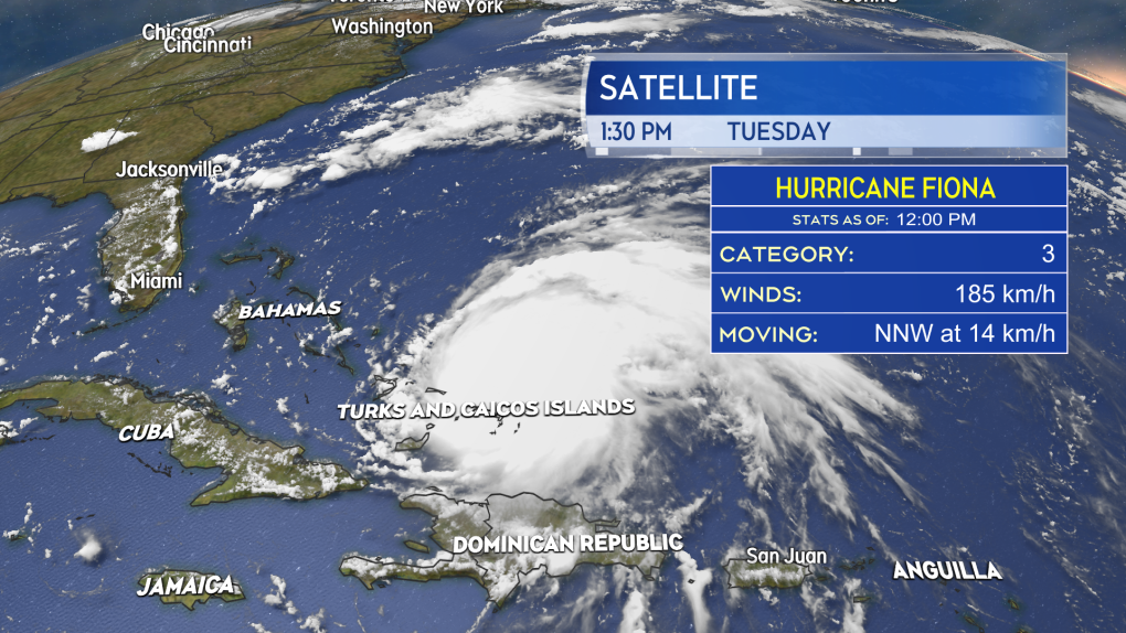 Hurricane Fiona is currently a Category 3 hurricane bringing hurricane conditions to parts of the Turks and Caicos Islands as it continues to move northward.
TRACK
The hurricane is forecast to move north into an area of favourable ocean water temperatures and atmospheric conditions allowing it to become a Category 4 hurricane, with maximum sustained winds near 220 kilometres per hour as it passes west of Bermuda late Thursday. While a direct hit to Bermuda is not forecast, the Island is still being advised to monitor the progress of the hurricane.
The National Hurricane Center then brings Fiona as a Category 3 hurricane into the Scotia Slopes marine area south of Sable Island Friday night. Fiona is then forecast to approach eastern Nova Scotia as a Category 2 hurricane Saturday morning.
The forecast cone -- or the area the centre of the storm is expected to take a path through -- still encompasses a large area of Atlantic Canada, stretching from Halifax on the western side, to the Burin Peninsula in Newfoundland on the eastern side. The cone does not predict the entirety of the area to be impacted by the storm nor the intensity of those impacts.
 Hurricane Fiona is forecast to enter the Atlantic Canada region as a Category 2 hurricane transitioning to a powerful post-tropical storm late Friday into Saturday.
POST-TROPICAL TRANSITION
Regardless of the approach intensity and track of the hurricane, it is expected to undergo a post-tropical transition as it passes through Atlantic Canada.
This starts as the hurricane interacts with a weather front (cold front) on Friday and continues into the weekend. There will be a number of changes to the storm as a result including:
- An increase in speed northwards. Fiona will cover as much or more distance between Friday morning and Saturday as it will between Tuesday morning and Friday morning.
- An increase in the size of the storm. Fiona will take on a more stretched, asymmetrical appearance and cover a larger area.
- The intensity of rain and wind diffuses away from the centre of the storm but impacts a broader area. This means that heavy rain and high winds may be experienced further out from the centre of Fiona.
![]() As Hurricane Fiona undergoes post-tropical transition it will go from symmetrical with intense conditions near the centre (left) to asymmetrical, larger and with more diffused rain and wind (right).”>
As Hurricane Fiona undergoes post-tropical transition it will go from symmetrical with intense conditions near the centre (left) to asymmetrical, larger and with more diffused rain and wind (right).”>
ALERTS ISSUED
Environment Canada and the Canadian Hurricane Centre posted a Tropical Cyclone Information Statement for Newfoundland, Prince Edward Island, eastern New Brunswick, and all but the southwest of Nova Scotia Tuesday morning. They state that they are monitoring the hurricane, that the storm will become quite large and impact a broad area, and that the Canadian Hurricane Centre will begin six-hourly bulletin updates Tuesday night or early Wednesday.
 An initial tropical weather statement was issued by the Canadian Hurricane Centre Tuesday morning.
THE MARITIMES
While this storm will be large with broad impacts, we still need to narrow down the approach it will take through the region. A move towards Newfoundland will lessen the intensity of the impacts for the Maritimes, while a pass near or through Cape Breton would increase them. That will be narrowed considerably over the next few days.
The National Hurricane Center is giving a moderate-to-high probability of eastern P.E.I. and eastern Nova Scotia getting into tropical storm force winds (one minute sustained wind of 63+ kilometres per hour, stronger gusts) Friday night into Saturday morning. That said, the entirety of the Maritimes should be checking in on the forecast for the storm daily.
Some initial preparation for a high wind, heavy rain event would be appropriate. Things like checking working condition of generators and sump pumps, and making sure property drainage is free and clear of debris.
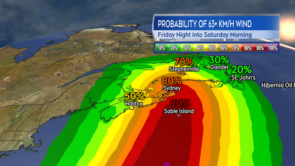 The probability of eastern parts of the Maritimes experiencing tropical storm force winds Friday night into Saturday has increased.
Shopping Trends
The Shopping Trends team is independent of the journalists at CTV News. We may earn a commission when you use our links to shop. Read about us.


CTVNews.ca Top Stories

Donald Trump says Canada becoming 51st U.S. state is 'a great idea.' Jean Charest calls the comment a 'wake-up call'
U.S. President-elect Donald Trump is taking aim at Canada once more, saying it would be 'a great idea' to make it America's ‘51st state.'
'You're either with Beijing or you're with Washington': Ford says to Mexico in CNN interview
Ontario Premier Doug Ford has a message for Mexico as the threat of tariffs by incoming president Donald Trump hangs over both sides of the U.S. border.
There are 88 new Order of Canada appointees. Here's a look at some of the most notable names
Ryan Reynolds, Scott Oake and Maureen Ann Jennings are among the 88 new recipients of the Order of Canada.
NEW
NEW Here's how the cost of living challenges are shaking up Canadian seniors' retirement plans
With the high cost of living increasingly a concern, some seniors are making sacrifices to help their adult children and grandchildren make ends meet. Here are some of their stories.
Iconic Halifax ship Theodore Too partially sunk at Ontario dock
An iconic ship that was a fixture in Halifax Harbour for 21 years has partially sunk in Ontario.
Oscars shortlist revealed. See which movies made the cut
A shortlist of Oscar contenders in ten categories has been revealed.
Canada Post provides update on Santa letters
Canada Post provided an update Wednesday about letters addressed to Santa, reassuring children that their letters will be delivered to the North Pole by Christmas Eve. However, Santa won't have time to respond to them.
Thousands of toddler step stools recalled after child's head gets stuck
Thousands of toddler step stools are being recalled after a child's head got stuck in one.
Brazilian judge orders Adele song removed over plagiarism claim
A judge in Rio de Janeiro has ordered the global removal of a 2015 song by British singer Adele due to a plagiarism claim by a Brazilian musician, which Universal Music is fighting on appeal.
Toronto
-

Yorkdale Station, part of Line 1 shut down due to police investigation
Subway service along a four-station stretch of Line 1 has been shut down due to a police investigation at Yorkdale Station.
-
Donald Trump says Canada becoming 51st U.S. state is 'a great idea.' Jean Charest calls the comment a 'wake-up call'
U.S. President-elect Donald Trump is taking aim at Canada once more, saying it would be 'a great idea' to make it America's ‘51st state.'
-
Ontario reveals its top baby names. Here are the top 10
Ontario has revealed the most popular baby names of 2023 and one name is reigning supreme for the 15th year in a row.
Calgary
-

More than 100 cats surrendered by Calgary homeowner
The Calgary Humane Society says it is investigating after 110 cats were surrendered into its care by a Calgary homeowner.
-
Emaciated bear cub rescued by Alberta wildlife organization
Officials at an Alberta animal rescue organization have taken in an emaciated black bear cub found wandering alone earlier this month.
-
Mayoral and council candidates in Calgary required to provide criminal record check
Candidates running for city council or mayor in Calgary will be required to provide a criminal record check from the Calgary police when submitting nomination papers.
Edmonton
-

Explosion reported at Strathcona Spirits Distillery
Fire crews were called to reports of an explosion at Strathcona Spirits Distillery in south Edmonton at 10:16 a.m. on Wednesday.
-
Police officer hurt, 2 arrested after gun fight reported at Stantec Tower
A police officer and two men were taken to hospital on Tuesday after an arrest at Stantec Tower.
-
Family escapes north Edmonton house fire
A family of five escaped a house fire in north Edmonton early Wednesday morning.
Montreal
-

Quebec doctors Laurent Duvernay-Tardif, Joe Schwarcz appointed to Order of Canada
Numerous Quebecers, including former professional footballer Dr. Laurent Duvernay-Tardif and McGill University and CJAD 800's Dr. Joe Schwarcz, were among those appointed to the Order of Canada.
-
Quebec man pleads guilty to spreading hate speech about Jews, trying to make 3D-printed guns
A Quebec man has pleaded guilty to attempting to manufacture multiple firearms with a 3D printer, including an AR-15, and spreading hate speech about the Jewish community.
-
Synagogue on Montreal's West Island targeted by alleged arson
A synagogue on Montreal's West Island was the target of an alleged arson attack.
Ottawa
-

Olivia, Adam top baby names in Ottawa for 2023
Ontario unveiled the top baby names for 2023, and Olivia and Adam occupy the top spots in Ottawa.
-
Slight increase in households exceeding three-item garbage limit as full enforcement begins
New statistics from the City of Ottawa show there was an increase in households exceeding the new three-item garbage limit as the final phase of the new rules began earlier this month.
-
SIU investigating after man found unresponsive in OPP cell hours after being arrested in eastern Ontario
Ontario’s Special Investigations Unit (SIU) has invoked its mandate after a suspect was found unresponsive in a holding cell in Long Sault Monday, according to the Ontario Provincial Police (OPP).
London
-

London police say two recent shootings are connected
Police haven't said how, but announced on Wednesday that a shooting on Simcoe Street in November, is related to a shots fired investigation at London Health Sciences Centre (LHSC) from Dec. 14.
-
Driver flees the scene of house, gas meter struck in London
Ridout Street north was shut down between Dufferin and Queens and east of Fullerton
-
Highway 21 reopens following "stubborn" structure fire in Goderich
A structure fire in Goderich is being described as "stubborn." Chief Jeff Wormington told CTV News a vacant home on Victoria Street will be a "total loss."
Barrie
-

Serious multi-vehicle crash on Highway 93 under investigation
Provincial police closed Highway 93 in Springwater Township Wednesday morning following a serious multi-vehicle collision.
-
Police to provide update on Sharif Rahman homicide investigation
Owen Sound Police and provincial police scheduled a press conference on Wednesday afternoon to reveal details about the homicide investigation of Sharif Rahman, the restaurant owner who was fatally assaulted last year.
-
Huntsville man arrested in sexual assault investigation involving a child
A Huntsville man is facing charges in connection with a historic sexual assault investigation involving a complainant who police say was a child at the time.
Northern Ontario
-

Sudbury police find 69% bail compliance in recent check
Last week, Greater Sudbury Police Service conducted bail compliance checks and warrant apprehension focused on violent and high-risk offenders.
-
BREAKING
BREAKING One child taken to hospital after Sudbury school bus rear ended
One child has been taken to hospital after a school bus was rear-ended on Municipal Road 35 east of Azilda in Greater Sudbury on Wednesday morning.
-
War of words escalates into lawsuits between Greater Sudbury, roads contractor
A bitter battle between Greater Sudbury and a southern Ontario roads contractor related to a troubled repair job on the Kingsway is now in the courts.
Kitchener
-
 BREAKING
BREAKING Police investigating after multiple people reported home damage 'consistent with shots fired' in Cambridge
Police said multiple residences reported damages “consistent with shots fired.”
-
$3M award program offers help for Waterloo Region post secondary school students
Some incoming college and university students in Waterloo Region will get financial help thanks to a newly announced award program.
-
Beloved Canadian tugboat 'Theodore Too' partially sinks
Theodore TOO, the life-size replica of Theodore Tugboat, has partially sunk in a St. Catharines port.
Windsor
-

'High visibility' initiative launching at 920 Ouellette in Windsor
While frequent calls are received, police say about 75 per cent of them are non-criminal — including well-being checks, ambulance requests and non-violent persons in crisis.
-
Semi-automatic rifle seized at Ambassador Bridge
Canada Border Services Agency officers seized a semi-automatic rifle at the Ambassador Bridge.
-
Missing 27-year-old woman sought by Windsor police
Windsor police are looking for a missing 27-year-old woman.
Winnipeg
-

Manitoba parents being warned of violent online network targeting kids
The Manitoba RCMP is warning parents about a violent online network that is targeting children and youth.
-
Camp Morgan coming down after two years in wake of landfill search
After two years of activity, a camp calling for the search of a Winnipeg landfill is coming down.
-
Colleen Bready's forecast: Another hit of wintry weather is expected in Manitoba
Get ready for another wintry blast of snow and bitter cold in southern Manitoba.
Regina
-

'Alarmingly high': Homelessness in Regina up 255 per cent since 2015, according to study
There are currently 824 people in Regina who are experiencing homelessness, according to the 2024 point-in-time homelessness count.
-
Moose Jaw police warning of possible resurgence of grandparent scams
The Moose Jaw Police Service (MJPS) is asking the public to be vigilant as the holidays approach, as grandparent scams may begin to re-circulate within the community.
-
Freezing rain turns streets into skating rinks, literally in this Sask. community
They say the world is your oyster, and the streets are your stating rink – or at least they are in this Saskatchewan community.
Saskatoon
-

Six potential builders shortlisted for Saskatoon City Centre School development
The construction of a new public elementary school to serve Saskatoon’s core neighbourhoods is moving forward after years of delay.
-
Saskatoon under extreme cold warning Wednesday
Saskatoon faced wind chills as low minus 41 C on Wednesday morning, with an extreme cold warning in effect.
-
Rare video of a weird 90s CFL matchup between the Riders and the short-lived Baltimore Stallions
The CFL in the 1990s was a bit weird and interesting at the same time. Weird, in that teams from Texas, Alabama and Baltimore were playing in the Canadian football league. And interesting because it made for some good games.
Vancouver
-

Pedestrian struck by car in New Westminster
Police in New Westminster have closed McBride Boulevard following a crash involving a pedestrian early Wednesday morning.
-
Delta police issue new call for missing man who abandoned car on Alex Fraser Bridge
Police have made a renewed call for help in finding a man who went missing after abandoning his car on a busy Delta, B.C., highway two weeks ago.
-
Semi-truck driver arrested for impaired driving after crash in Richmond, B.C.
Mounties in Richmond, B.C., are looking for witnesses to a two-vehicle collision involving a semi-truck driver suspected of impaired driving.
Vancouver Island
-

Winter weather continues for much of B.C.
Environment Canada has issued multiple warnings for weather as a winter storm continues to make its way over the province.
-
Semi-truck driver arrested for impaired driving after crash in Richmond, B.C.
Mounties in Richmond, B.C., are looking for witnesses to a two-vehicle collision involving a semi-truck driver suspected of impaired driving.
-
2 B.C. police officers charged with sexual assault
Two officers with a Vancouver Island police department have been charged with the sexual assault of a "vulnerable" woman, authorities announced Tuesday.
Kelowna
-

B.C. man sentenced for 'execution-style' murder of bystander in drug trade conflict
A B.C. man convicted of the "intentional and ruthless killing of a bystander" while acting as an enforcer in the drug trade has been sentenced for a second time in the slaying.
-
Paramedic threatened at knifepoint inside Kelowna ambulance station, union says
The union representing ambulance paramedics in B.C. is calling on the province to beef up security after they say a knife-wielding woman attacked a worker.
-
Car stolen, fleeing suspect found hiding in basement in Kelowna, B.C.
Mounties have arrested a suspect who allegedly stole a car in Kelowna, B.C., before fleeing on foot and hiding from police in the basement of a home.


