Hurricane Lee moving northwest, poses weekend risk to Atlantic Canada
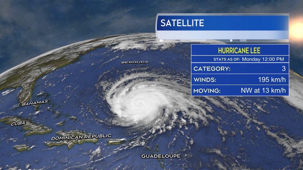
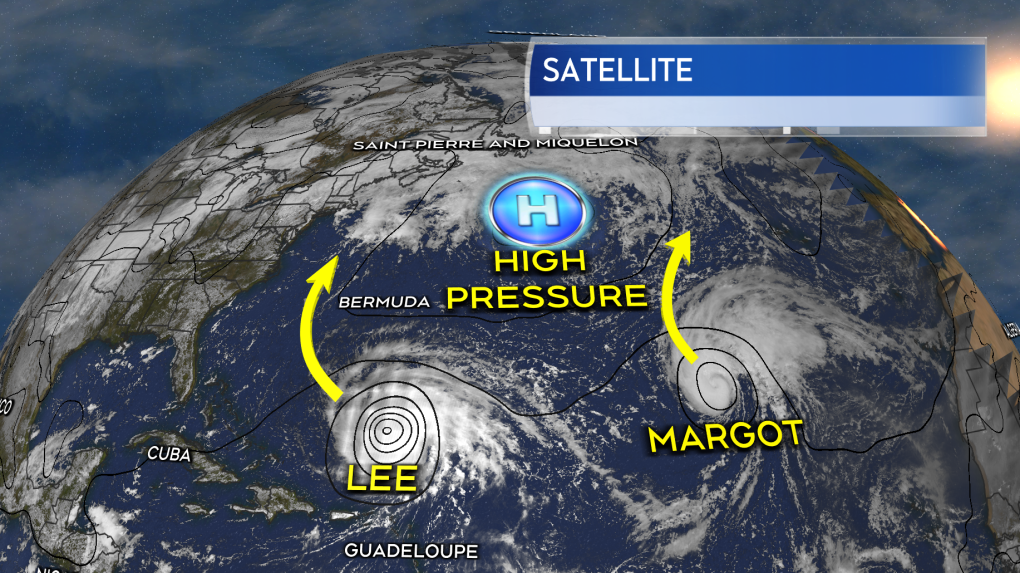
As of Monday afternoon, Lee is a Category 3 hurricane with maximum sustained winds near the eye of the storm at 195 km/h. The hurricane is moving northwest at near 13 km/h, starting to make a turn around the southern edge of a high pressure system that sits to the east of it.
 The current status of hurricane Lee as of Monday afternoon.
In the latest forecast cone from the National Hurricane Center, which extends out five days, the storm does not yet reach land areas of Atlantic Canada, but does encompass the southern marine districts of Georges Bank and West Scotian Slope. The intensity of the storm at that time, Saturday, is currently forecast to be a category one hurricane with maximum sustained winds near 130 km/h. A further expansion of the forecast cone northward over the next 24 hours, which looks likely, would start to reach into Nova Scotia and New Brunswick.
The forecast cone is the area in which the centre of the storm is expected to take a path through and it has been found to historically be accurate about 70 per cent of the time. The cone does not represent the entirety of the area that could experience impacts from the storm. The cone broadens in size considerably the further out in time it goes due to increased uncertainty in the forecast.
 The current status of hurricane Lee as of Monday afternoon.The current timing of Lee, of which there is uncertainty in as well, would pose a weather threat to the Maritimes for the upcoming weekend. Stormy conditions are a risk for both Saturday and Sunday, the inclement weather arriving ahead of the centre of the storm may be on the slower side to progress through the region. It is still too early to determine a more precise path the storm could take through the Maritimes. Specific weather impacts and their intensity will be determined by that track. A higher confidence in those details will emerge through the week, particularly as we get about three days out from the storms possible approach which would be the Wednesday/Thursday of this week.
 High pressure to the east of Lee increases the risk it will have an impact on Atlantic Canada as that system could delay an eventual turn eastward of the storm.
One aspect of these weather systems to keep in mind is that they see a notable increase in size as they move northward. Weather impacts such as the rain and wind become more diffused from the centre of the storm, but cover a larger area.
We have experience with tropical storms and hurricanes here in the Maritimes. The most far reaching impact is likely to be a risk of power outages. The risk of outages is increased at this time of the year due to the presence of leaves on the trees which act to increase the force of high winds on them. More localized impacts of coastal surge and heavy rain would need to be watched for as well should the storm have a direct impact on us.
It's time to start reviewing general household storm/emergency plans. As an example if you use a sump pump in heavy rain or a generator in a power outage you should take the time to make sure those are in working order. Continue to check in on the status of the storm and forecast for your area this week.
Watch for updates daily on CTV News Noon, Five, Six, Late, and at ctvnewsatlantic.ca.
CTVNews.ca Top Stories

BREAKING Toronto MP and former Liberal cabinet minister Marco Mendicino won't seek re-election
Marco Mendicino, a prominent Toronto member of Parliament and former minister of public safety and immigration, won't run in the next federal election, CTV News has learned.
U.S. soldier shot self in head before Cybertruck exploded outside Trump's Las Vegas hotel, officials say
The highly decorated U.S. Army soldier inside the Tesla Cybertruck that burst into flames outside U.S. President-elect Donald Trump's Las Vegas hotel shot himself in the head before the explosion, officials said Thursday.
Wayne Osmond, singer and guitarist for The Osmonds, is dead at 73
Wayne Osmond, a singer, guitarist and founding member of the million-selling family act The Osmonds, who were known for such 1970s teen hits as "One Bad Apple," "Yo-Yo" and "Down By the Lazy River," has died. He was 73.
Toys "R" Us Canada closing 5 stores, expand HMV and add play spaces to some shops
Toys "R" Us Canada says it is closing five Ontario stores and revamping several others as it works to "optimize" its business.
FORECAST Weather warnings issued in 7 provinces and territories
Wintry weather conditions, including heavy snow and wind chill values around -55, prompted warnings in seven provinces and territories Thursday.
The taboo of talking about money, according to one survey
Most Canadians are comfortable talking about money with their close friends and family members, but, according to a recent survey, some find it awkward to discuss finances outside their inner circle and the issue is more prominent among women.
Grieving orca mother Tahlequah carries dead baby for the second time
The famous mother orca who made waves around the world for carrying her dead calf for 17 days has suffered another tragic loss.
Rosita Missoni, matriarch of Italian fashion house that made zigzag knitwear iconic, dies at age 93
Rosita Missoni, the matriarch of the iconic Italian fashion house that made colorful zigzag-patterned knitwear high fashion and helped launch Italian ready-to-wear, has died. She was 93.
Apple to pay US$95M to settle lawsuit accusing Siri of snoopy eavesdropping
Apple has agreed to pay US$95 million to settle a lawsuit accusing the privacy-minded company of deploying its virtual assistant Siri to eavesdrop on people using its iPhone and other trendy devices.


