Marathon snowstorm continues Sunday into Monday for the Maritimes
As parts of eastern Nova Scotia and eastern Prince Edward Island report snow amounts of 30 to 60 cm already down, there is more to come over the next few days. Cancellations and impacts to travel services continue to add up in the region.
The ocean storm bringing snow to the region continues to be stalled off the Atlantic coastline of Nova Scotia. It will remain that way through Sunday before finally moving further away towards the northeast late on Monday.
On Sunday, the steadiest and heaviest snow will fall over central and eastern areas of both Prince Edward Island and Nova Scotia. Central areas of Nova Scotia may have a break, or lull, in the snow Sunday morning into afternoon before it picks back up again for a period of time Sunday evening.
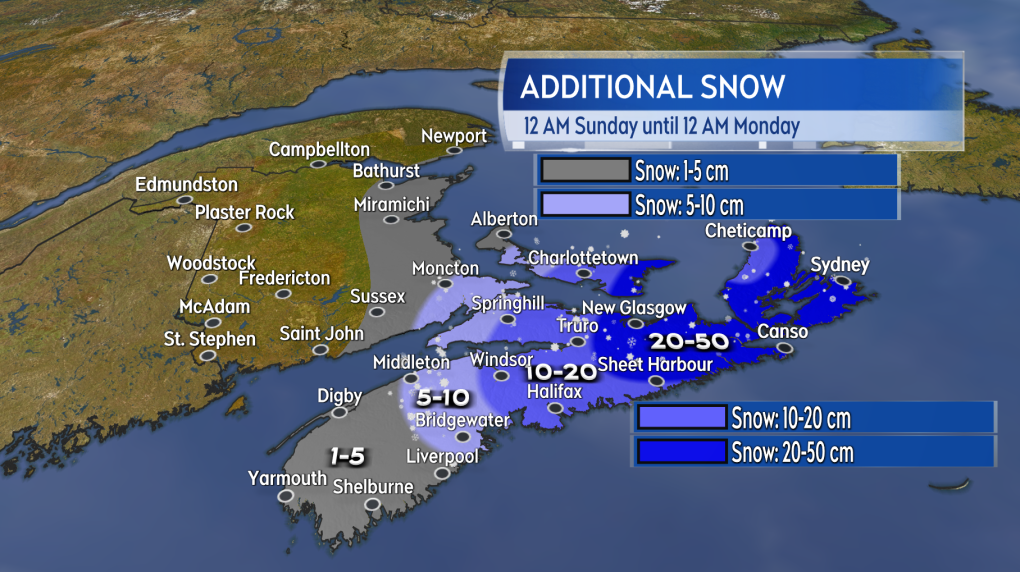 Additional snow through Sunday.
By Monday morning, the remaining snow in the Maritimes will have become more intermittent and lighter. Bands of snow are expected to continue around Prince Edward Island and eastern areas of Nova Scotia, with periods of flurries for much of the remainder of the Maritimes.
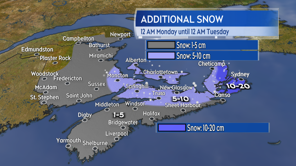 Additional snow through Monday.
Through the course of this multi-day snowstorm there will be some astoundingly high overall totals. By the end of Monday it is possible that parts of Cape Breton have totals in the range of 80 to 100 cm. Queens and Kings County, Pince Edward Island could have totals of 30 to 60 cm. Overall totals in central areas of Nova Scotia, including Halifax, are likely to also have 30 to 60 cm. To give some context, the climate average February snow for Halifax is 45 cm, Sydney 65 cm, and 58 cm for Charlottetown.
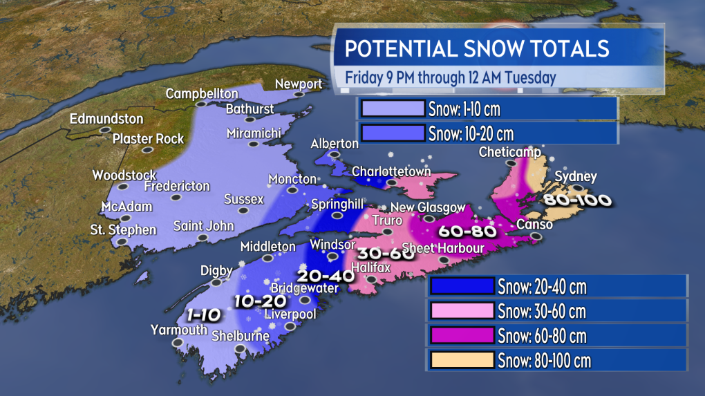 Estimates of some possible snow totals Friday night through Monday.
A gusty north and northeast wind continues Saturday night through Monday. The northerly wind has kept colder air in place keeping the precipitation mostly in the form of snow. Gusts of 30 to 60 km/h are creating areas of drifting and blowing snow for parts of Prince Edward Island and central/eastern Nova Scotia. Further periods of visibility of less the one kilometre are a risk Saturday night through Sunday. The wind while remaining northerly is expected to be diminish by Tuesday morning.
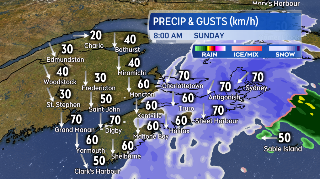 Along with falling snow a gusty northerly wind continues through Sunday producing areas of drifting and blowing snow.Winter Storm Warnings continue for Cape Breton as well as Pictou, Antigonish, and Guysborough Counties Nova Scotia. A Snowfall Warning for southern Colchester, Hants and Halifax Counties. Special Weather Statements extend across Kings and Queens Counties, Prince Edward Island and into the Annapolis Valley and South Shore of Nova Scotia.
Blowing Snow Advisories were also put into effect for parts of Nova Scotia by Environment Canada Saturday afternoon.
Shopping Trends
The Shopping Trends team is independent of the journalists at CTV News. We may earn a commission when you use our links to shop. Read about us.


CTVNews.ca Top Stories

Poilievre writes to GG calling for House recall, confidence vote after Singh declares he's ready to bring Liberals down
Conservative Leader Pierre Poilievre has written to Gov. Gen. Mary Simon, imploring her to 'use your authority to inform the prime minister that he must' recall the House of Commons so a non-confidence vote can be held. This move comes in light of NDP Leader Jagmeet Singh publishing a letter stating his caucus 'will vote to bring this government down' sometime in 2025.
BREAKING
BREAKING At least 2 dead and 60 hurt after a car drives into a German Christmas market in a suspected attack
A car plowed into a busy outdoor Christmas market in the eastern German city of Magdeburg on Friday, killing at least two people and injuring at least 60 others in what authorities suspect was an attack.
Judge sentences Quebecer convicted of triple murder who shows 'no remorse'
A Quebecer convicted in a triple murder on Montreal's South Shore has been sentenced to life in prison without chance of parole for 20 years in the second-degree death of Synthia Bussieres.
'I understand there's going to be a short runway,' new minister says after Trudeau shuffles cabinet
Prime Minister Justin Trudeau added eight Liberal MPs to his front bench and reassigned four ministers in a cabinet shuffle in Ottawa on Friday, but as soon as they were sworn-in, they faced questions about the political future of their government, and their leader.
BREAKING
BREAKING Fake nurse Brigitte Cleroux sentenced for B.C. crimes
A woman who impersonated nurses in several provinces has been sentenced to seven years in prison for offences in British Columbia – where she illegally treated nearly 1,000 patients across multiple communities.
Poilievre to Trump: 'Canada will never be the 51st state'
Conservative leader Pierre Poilievre is responding to U.S. president-elect Donald Trump’s ongoing suggestions that Canada become the 51st state, saying it will 'never happen.'
Toronto officials warn of possible measles exposure at Pearson airport
Toronto Public Health (TPH) is advising of another possible measles exposure at Canada’s largest airport.
Bail denied for Winnipeg woman accused of killing animals in online videos
Warning: This story contains disturbing details. Discretion is advised. A Winnipeg woman accused of making videos of animals being tortured and killed that were sold on the dark web was denied bail.
Party City closing in U.S., Canadian stores remain 'open for business'
The impending closure of all Party City locations in the United States will not extend into Canada.
Toronto
-

'Enough is enough': Toronto Jewish school struck by gunfire for third time since May
A Jewish elementary school in Toronto has been struck by gunfire for the third time in the last seven months.
-
6 arrested, 5 remain at large in auto theft ring that operated around Toronto Pearson Airport: police
Peel police have arrested seven people and issued arrest warrants for five more suspects who are allegedly part of a Quebec theft ring responsible for stealing more than 100 vehicles in and around Toronto Pearson International Airport.
-
Police say break-and-enter suspects were in Canada for 'purpose of committing criminal offences'
Five Chilean nationals who police believe were in Canada for 'the purpose of committing criminal offences' have been charged in connection with half a dozen break-and-enters across the Greater Toronto Area (GTA).
Calgary
-

3 people sent to hospital after serious crash on Deerfoot Trail
A serious crash closed part of Deerfoot Trail on Friday afternoon.
-
Calgary man arrested in connection with more than a dozen robberies
Police say charges have been laid against a 19-year-old man in connection with a series of robberies that targeted cannabis and convenience stores in Calgary and Edmonton.
-
Alberta announces plan to develop 'modernized' coal policy
The future of coal mining in Alberta will be governed by a new, modern approach, the province announced on Friday.
Edmonton
-

Second inmate dies at Edmonton Remand Centre in as many days
An inmate died at the Edmonton Remand Centre on Thursday night.
-
Child pornography charges laid against 52-year-old woman
A Sherwood Park woman has been charged with two child pornography offences.
-
Poilievre writes to GG calling for House recall, confidence vote after Singh declares he's ready to bring Liberals down
Conservative Leader Pierre Poilievre has written to Gov. Gen. Mary Simon, imploring her to 'use your authority to inform the prime minister that he must' recall the House of Commons so a non-confidence vote can be held. This move comes in light of NDP Leader Jagmeet Singh publishing a letter stating his caucus 'will vote to bring this government down' sometime in 2025.
Montreal
-

Judge sentences Quebecer convicted of triple murder who shows 'no remorse'
A Quebecer convicted in a triple murder on Montreal's South Shore has been sentenced to life in prison without chance of parole for 20 years in the second-degree death of Synthia Bussieres.
-
Police search for suspect in connection with woman's abduction, attempted homicide
A woman in her 20s who was possibly abducted by her ex is in hospital after the car she was in plunged into the Richelieu River.
-
Cold snap brings hope of a white Christmas in Montreal
A cold Christmas awaits Montrealers this year with varying mixes of sun and clouds.
Ottawa
-

Restaurants still waiting to see if GST/HST holiday impacts business
Reviews are beginning to come in from customers and restaurants a few days into the federal government's GST/HST holiday.
-
Man allegedly filming females in public washroom in business on Elgin Street, police looking for more victims
The Ottawa Police Service says a man has been arrested following a report alleging he was filming women inside a public washroom in a business on Elgin Street last weekend.
-
'Hot and frosty': Film industry booming in Ottawa
Ottawa is not only a hot spot for tourism, but also a landmark when it comes to the film industry and holiday movies, says the City of Ottawa.
London
-

Man dies after falling from building: LPS
London police say a man has died after falling from a building.
-
Fire destroys London Cricket Club memorabilia, equipment
A fire destroyed thousands of dollars worth of property and memorabilia at the London Cricket Club.
-
Manslaughter charge laid against London man after August drug bust
A London man has been charged with manslaughter after an OPP drug raid this summer. Police have released few details but say they used a search warrant at a West Elgin home Aug. 23.
Barrie
-

Multi-vehicle collision on Highway 11 in Oro-Medonte
Southbound traffic along Highway 11 through Oro-Medonte was brought to a crawl Friday after a multi-vehicle collision.
-
High school teacher charged with sexual assault amid allegations involving a student
A 51-year-old teacher from Georgina has been charged with sexual assault following allegations involving a student.
-
Driver charged after vehicle crashes into Barrie home
A driver was arrested Thursday night after a vehicle crashed into a home in Barrie.
Northern Ontario
-
Poilievre writes to GG calling for House recall, confidence vote after Singh declares he's ready to bring Liberals down
Conservative Leader Pierre Poilievre has written to Gov. Gen. Mary Simon, imploring her to 'use your authority to inform the prime minister that he must' recall the House of Commons so a non-confidence vote can be held. This move comes in light of NDP Leader Jagmeet Singh publishing a letter stating his caucus 'will vote to bring this government down' sometime in 2025.
-
Northern Ont. man illegally killed three moose, one deer
A man from the northwestern Ontario community of Dinorwic has been found guilty of multiple hunting offences and fined $6,500, banned from hunting for five years and placed on probation for 18 months.
-
North Bay-area man wanted on 19 charges, including spousal assault, drug trafficking
Police are asking for the public's help in finding a suspect wanted for a host of offences, ranging from assault to uttering death threats.
Kitchener
-

Guelph man pleads guilty to fleeing fatal crash involving cyclist
A Guelph driver, who previously admitted to failing to stop after a fatal crash, instead plead guilty to a different charge on Friday.
-
Police believe shots fired into Cambridge home was a targeted incident
Waterloo Regional Police Service now believes shot fired into a Cambridge home was a targeted incident.
-
Distillers not feeling the 'tax holiday' spirit
While some shoppers and store owners are celebrating the HST 'tax holiday' from the federal government, not all industries are feeling the holiday spirit.
Windsor
-

Clear Medical Imaging strike ends with arbitration agreement
The eight-week long strike action at Clear Medical Imaging has ended. According to officials, Unifor and the employer have agreed to binding arbitration.
-
Over $45,000 in cash and drugs seized: WPS
Two suspects have been arrested and over $45,000 in cash and drugs seized following an investigation by the Windsor Police Service (WPS).
-
Toll increase coming to the Windsor-Detroit Tunnel in 2025
Drivers heading through the Windsor-Detroit Tunnel in the new year will have to take some extra cash. A toll increase for those heading from Canada to the U.S. is scheduled for Jan. 1, 2025 .
Winnipeg
-

Bail denied for Winnipeg woman accused of killing animals in online videos
Warning: This story contains disturbing details. Discretion is advised. A Winnipeg woman accused of making videos of animals being tortured and killed that were sold on the dark web was denied bail.
-
Man suffers broken leg after being arrested by Winnipeg police; IIU investigating
The Winnipeg Police Service said the Independent Investigation Unit of Manitoba is investigating after a man suffered broken bones in his leg after being arrested.
-
Main Street Project struggling with financial donations, asking for help from Manitobans
Main Street Project is in need of financial donations.
Regina
-

Regina man creates snow sculpture to spread joy and inspire donations
A Regina man created a snow sculpture of a Santa head to spread joy and inspire donations to Big Brothers Big Sisters.
-
Highway closures in place as winter driving conditions return
After receiving another big dump of snow over the past couple of days, Saskatchewan drivers have had to contend with some treacherous driving conditions.
-
Local groups work to give people extra support this holiday season
As the holidays approach, outreach groups are working to give people in the community a bit of extra support.
Saskatoon
-

Saskatoon police release details about latest homicide
Saskatoon police are releasing new details about the city’s latest homicide, although no charges have yet been laid.
-
Search continues for man wanted in connection with all-day manhunt in northern Sask.
The Saskatchewan RCMP are still searching for 28-year-old Dallas Fulton, wanted in connection with a dangerous person alert sent out across the province in October.
-
Saskatchewan highway closed due to serious collision
The Saskatoon RCMP are currently responding to a serious collision on Highway 5, west of Meacham.
Vancouver
-

BCLC warns parents against the dangers of child gambling at Christmas
Scratch cards in stockings might seem like an exciting Christmas idea, but for those who are under the legal age limit, being lured into gambling too early could cause more mess than merriment further down the line, says the British Columbia Lottery Corporation.
-
Sex offender arrested after making advances toward girl, Port Moody police say
Police in Port Moody say they arrested a known sex offender Thursday after he allegedly breached his court-ordered conditions.
-
City confirms Stanley Park Train cancelled for the holiday season
Rides on Stanley Park’s iconic Christmas train will be shelved for another year for thousands of ticket holders, as officials confirm the train’s closure will continue for the remainder of the holiday season.
Vancouver Island
-

Victoria police make 42 arrests in retail theft crackdown
Police in Victoria say officers have made 42 arrests and recovered approximately $10,000 in stolen merchandise during a four-day retail theft operation targeting repeat offenders.
-
Loans, delays, legal action: B.C. renovator blames illness for project stalls, denies faking cancer
Two Metro Vancouver homeowners have come forward with new allegations against a local renovator accused of faking cancer to avoid repaying a debt, saying they are also owed money after handing over hefty sums for projects that have not been completed.
-
BC Civil Liberties Association calls for review of MAID legislation
The British Columbia Civil Liberties Association is calling on the provincial and federal governments to review medically-assisted dying legislation to ensure proper safeguards are in place.
Kelowna
-

Forfeited Hells Angels clubhouse in Kelowna, B.C., sold to the city
A former Hells Angels clubhouse that was seized by the British Columbia government in 2023 after years of fighting in court has been sold to the City of Kelowna.
-
Death of woman found in Kelowna's Waterfront Park in June deemed 'non-criminal in nature': RCMP
Police in Kelowna say a death they began investigating back in June has now been confirmed as "non-criminal in nature."
-
B.C. man sentenced for 'execution-style' murder of bystander in drug trade conflict
A B.C. man convicted of the "intentional and ruthless killing of a bystander" while acting as an enforcer in the drug trade has been sentenced for a second time in the slaying.


