Hurricane watches issued ahead of weekend arrival of Fiona
A series of hurricane and tropical storm watches were issued for Atlantic Canada by Environment Canada and the Canadian Hurricane Centre Thursday afternoon. A watch means that hurricane or tropical storm conditions are possible in the alerted area within 36 hours.
TRACK
Hurricane Fiona continues to pick up speed towards the north as a Category 4 hurricane, now moving at nearly 25 kilometres per hour. The storm is forecast to pass to the west of Bermuda and enter the Scotian Slope marine waters of Atlantic Canada as a Category 3 hurricane on Friday.
Landfall as a powerful post-tropical storm, equivalent to a Category 1 or 2 hurricane looks increasingly likely in eastern Nova Scotia Saturday morning. The forecast cone for that landfall has now narrowed to span eastern Halifax County across Cape Breton. Various computer models show a landfall somewhere in the area from Canso to near Louisbourg in Nova Scotia between 6 a.m. and 10 a.m. Saturday. Weather conditions in the Maritimes will deteriorate Friday night into Saturday morning.
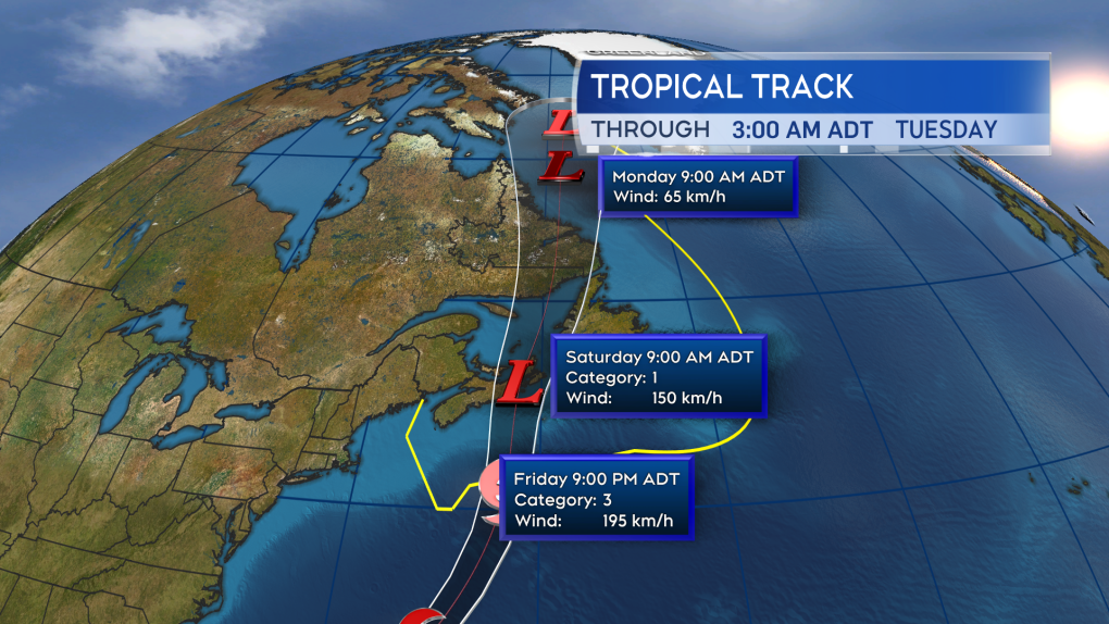 Fiona is expected to enter Canadian waters as a Category 3 hurricane late Friday. Becoming a power post-tropical storm as it makes landfall in eastern Nova Scotia Saturday morning.
HURRICANE WATCH ISSUED
A hurricane watch has been posted for Prince Edward Island and Halifax -- east across Nova Scotia. Tropical storm watches extend into the southwest of Nova Scotia and eastern New Brunswick.
The highest probabilities of hurricane force winds -- a one-minute sustained wind of 119 kilometres per hour or more -- are near and to the east of the expected landfall point. At this time, that includes parts of Guysborough and Antigonish counties on the mainland of Nova Scotia, as well as Cape Breton. Tropical storm force winds -- a one-minute sustained wind of 63 kilometres per hour -- are being given a high probability across P.E.I. and Halifax – in eastern Nova Scotia.
A moderate probability of a tropical storm force wind extends into the south shore of Nova Scotia and southeastern New Brunswick. Gust strength will exceed those one-minute sustained winds.
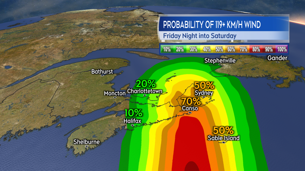 The highest probability of a hurricane force wind will be near and to the east of the landfall point. Currently looking most likely to be in eastern Nova Scotia.
 The risk of tropical storm force winds extends across much of Nova Scotia, Prince Edward Island, and into southeastern New Brunswick. That is a one minute sustained wind near 63 km/h with gusts possibly reach 100 km/h or higher.
WIND
Wind will increase in strength for much of the Maritimes Friday night into Saturday morning.
Peak gusts in eastern Nova Scotia and P.E.I. could reach 120 to 150 kilometres per hour due to being in proximity to the centre of the storm as it passes. That said, widespread gusts reaching 90 to 120 kilomtres per hours look possible, extending as far west as Halifax in Nova Scotia.
Gusts reaching 70 to 90 kilometres per hour could possibly extend into the southwest of Nova Scotia and eastern New Brunswick. Wind direction will primarily be out of the north and northwest. The exception is the area east of the landfall point, most likely Cape Breton, where the direction will be easterly turning southerly.
Wind of that strength will have the potential to cause power outages. In the eastern part of the region, where the wind is forecast to be strongest, there is an increased risk of tree and branch falls. Where the wind is onshore, it will help to produce a ferocious surf and risk of storm surge.
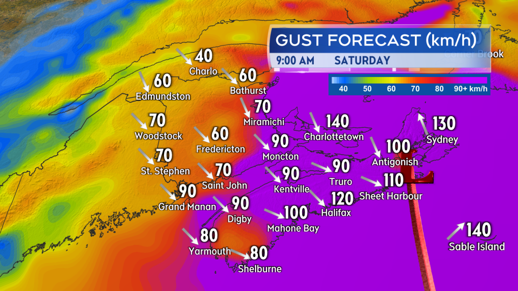 The strongest wind gusts look increasingly likely for eastern Nova Scotia and Prince Edward Island.
STORM SURGE
The greatest risk of a damaging storm surge looks to be the eastern and northern coastlines of Nova Scotia, the southeastern coastline of New Brunswick, and the northern coastline of P.E.I. The very low barometric pressure in the centre of the storm will allow for ocean water to rise up under it.
Intense winds will increase wave action against the coast further increasing the risk of flooding or damage. Near coastal waves reaching 10 metres, or 30 feet, may be present on the eastern shore of Nova Scotia late Friday night into Saturday morning.
A significant build of wave height in the Gulf of St. Lawrence is also expected, increasing the risk of erosion on north facing beaches of P.E.I. There is a period of high tide for the eastern part of the Maritimes Saturday morning -- particular caution should be taken during that tide. Waves and risk of storm surge should diminish moving through Saturday afternoon into Saturday evening.
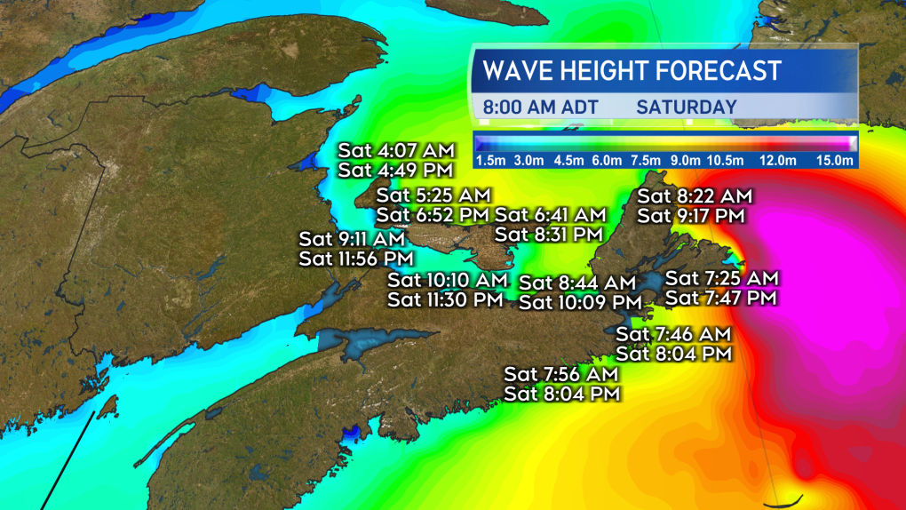 The risk of a damaging storm surge is highest in the east of the Maritimes. Extra caution should be taken if by the coast in that area particularly during the high tide Saturday morning.
RAINFALL
Torrential rain is expected for eastern parts of the Maritimes Friday night into Saturday morning. Friday through Saturday could see rain totals of 80 to 200 millimetres in eastern P.E.I. and eastern Nova Scotia increasing the risk of flash flooding and washouts. Rainfall totals could reach 50 to 80 millimetres extending towards the west of P.E.I. and central areas of Nova Scotia. There is potential for heavy rainfalls to quickly move into New Brunswick and the southwest of Nova Scotia.
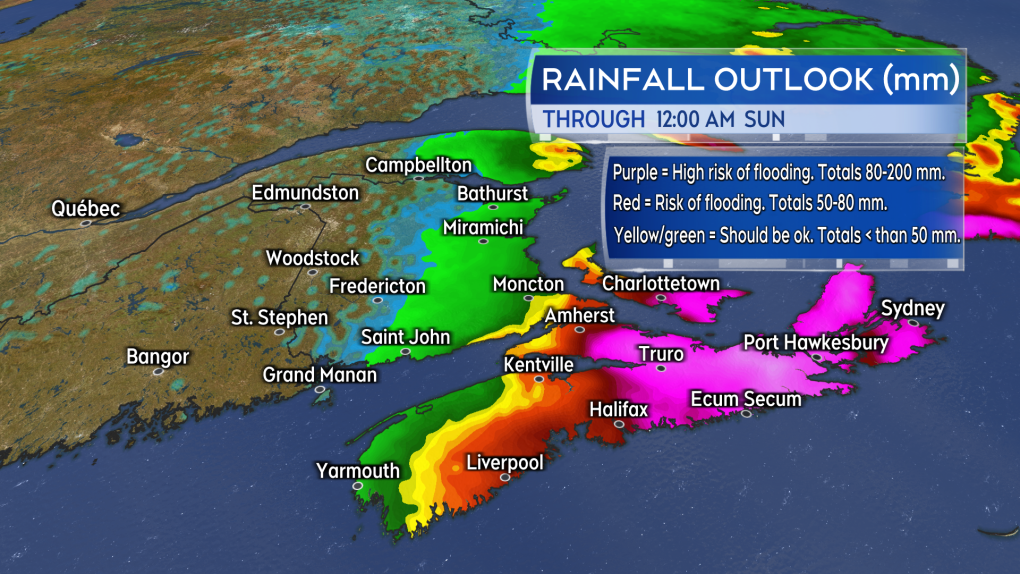 The risk of flooding is expected to be highest in eastern Prince Edward Island and eastern Nova Scotia. Rain in that part of the Maritimes could total 80 to 200 mm Friday through Saturday.
PREPARATIONS
Maritimers who have them should make sure that sump pumps and generators are in working order and the drainage on their property is clear of debris.
Other storm preparations to take include:
- having batteries for use in flashlights and lamps
- making sure mobile devices are charged
- stocking up on food and medication to last a period of 72 hours
- not travelling during the passage of the storm and the worst of the inclement weather


CTVNews.ca Top Stories

McGill says pro-Palestinian protest outside senior administrator's home 'crosses the line'
McGill University has denounced a pro-Palestinian protest held Sunday outside the home of one of its senior administrators.
What is BORG drinking, and why is it a dangerous trend? An expert explains
If you've been to a party lately and haven't seen someone drinking a BORG, you're likely not partying with college students.
The world's best airline is paying staff a bonus of 8 months' salary
Singapore Airlines will reward its employees with a bonus worth nearly eight months of salary, a person familiar with the matter told CNN on Friday.
Katy Perry sings goodbye to 'American Idol'
Katy Perry said her goodbyes on 'American Idol' after seven seasons. On Sunday night’s live 'idol' season finale, a medley of Perry's hit songs were performed, including 'Teenage Dream,' 'Dark Horse' and 'California Gurls.'
Red Lobster probes 'endless shrimp' losses after bankruptcy filing
U.S.-based restaurant chain Red Lobster has filed for Chapter 11 bankruptcy protection in a Florida court after securing $100 million in financing commitments from its existing lenders, the company said on Sunday.
Judge cites error, will reopen sentencing hearing for man who attacked Nancy Pelosi's husband
A federal judge will reopen the sentencing hearing for the man who broke into Nancy Pelosi's San Francisco home and bludgeoned her husband with a hammer after the judge failed to allow him to speak during his court appearance last week.
U.S. Supreme Court rejects appeal from former Guantanamo detainee Omar Khadr
The U.S. Supreme Court on Monday rejected an appeal by a Canadian-born former Guantanamo detainee who was seeking to wipe away his war crimes convictions, including for killing a U.S. soldier in Afghanistan.
Microsoft's AI chatbot will 'recall' everything you do on a PC
Microsoft wants laptop users to get so comfortable with its artificial intelligence chatbot that it will remember everything you're doing on your computer and help figure out what you want to do next.
Woman, 35, in critical condition after her truck collided with a Via Rail train near Montreal
A 35-year-old woman is in critical condition after the pick-up truck she was driving was struck by a Via Rail passenger train Monday morning in Quebec's Monteregie region.
Shopping Trends
The Shopping Trends team is independent of the journalists at CTV News. We may earn a commission when you use our links to shop. Read about us.


Toronto
-

Investors watching posts from 'Crypto King' in the wake of fraud, money laundering charges
Former investors of the self-styled “Crypto King” say they are watching his social media accounts and worried his displays of wealth are signs he’s spending their money, even now, as another large expense tied to Aiden Pleterski has triggered a previously unreported lawsuit.
-
Woman dead after stabbing in Mississauga: police
A woman is dead and a suspect is outstanding after a stabbing at a Mississauga hotel on Monday morning, police say.
-
'The root cause': Canada outlines national action plan to fight auto theft
The federal government is launching what it calls its 'national action plan' to combat auto thefts, which will include stronger penalties for thieves, and increased information sharing between police agencies, government officials and border enforcement.
Calgary
-

Calgary youth slings lemonade to raise money for Autism Asperger's Friendship Society
Inflation does not appear to exist at Dane's Lemonade Stand. "No, it does not," Dane Benesh said. Monday, in Copperfield, a tall glass of his lemonade cost the same $1 it did when he started in 2018.
-
Family Fun Day at Genesis Centre puts focus on safety and inclusion for special-needs children
The goal at Calgary's Genesis Centre on Monday was to make sure every single kid who walked through the doors felt included.
-
Status of wildfire that threatened Fort McMurray changed to 'being held'
A wildfire that forced thousands of people to evacuate several Fort McMurray neighbourhoods last week is no longer classified as out-of-control.
Edmonton
-

Status of wildfire that threatened Fort McMurray changed to 'being held'
A wildfire that forced thousands of people to evacuate several Fort McMurray neighbourhoods last week is no longer classified as out-of-control.
-
Canucks' Brock Boeser out for decisive Game 7 vs. Oilers: coach
Canucks star Brock Boeser will miss Game 7 of Vancouver's second-round playoff series Monday against the Edmonton Oilers, according to reports.
-
'The root cause': Canada outlines national action plan to fight auto theft
The federal government is launching what it calls its 'national action plan' to combat auto thefts, which will include stronger penalties for thieves, and increased information sharing between police agencies, government officials and border enforcement.
Montreal
-
McGill says pro-Palestinian protest outside senior administrator's home 'crosses the line'
McGill University has denounced a pro-Palestinian protest held Sunday outside the home of one of its senior administrators.
-
Two-year-old child found unconscious in residential swimming pool near Quebec City: police
A two-year-old child was found unconscious in a residential swimming pool in the municipality of Saint-Apollinaire, in Quebec's Chaudière-Appalaches region, around noon on Monday, Quebec provincial police say.
-
Jury finds Andrei Donet guilty of second-degree murder in stabbing death of Montreal teen
A jury has found a 21-year-old man guilty of second-degree murder in the stabbing death of Montreal teenager Jannai Dopwell-Bailey outside his school in 2021.
Ottawa
-

Thousands come out for last day of Canadian Tulip Festival on Victoria Day
Thousands came out for the final day of the Canadian Tulip Festival on Victoria Day
-
St. Laurent Station to stay closed until at least Wednesday: OC Transpo
The St. Laurent LRT station will remain closed until at least Wednesday as OC Transpo continues to repair and inspect damaged ceiling tiles and concrete above both rail platforms.
-
Stittsville residents seeking answers as bylaw cracks down on street basketball nets
Stittsville residents on Kearnsley Way are seeking answers after an unusual bylaw crackdown on Friday. Every home with a basketball net received a ticket instructing homeowners to remove their nets from the road.
London
-

'People are dying': Memorial Service held for homeless Londoners who have passed away
A small memorial service held in front of London City Hall Monday intended to send a message to politicians, the plans to solve the homeless crisis need to move more quickly.
-
ATV and dirt bike drivers airlifted to hospital after crash
An ATV driver has been taken to hospital with serious injuries after colliding with a dirt bike in South Bruce.
-
SIU investigating after London, Ont. man injured during arrest
The Special Investigations Unit is investigating after a 30-year-old London man sustained injuries while being arrested.
Barrie
-

Severe thunderstorm warning: strong winds and hail threaten Simcoe Muskoka
Environment Canada meteorologists are monitoring an area of severe thunderstorms that could generate strong wind gusts and nickel-to-tonie-size hail.
-
New cenotaph unveiled in Warminster to honour veterans
A new cenotaph was unveiled in Warminster on Sunday.
-
19-year-old driver caught speeding double the posted limit
A 19-year-old driver was caught driving double the posted speed limit in Innisfil on Sunday.
Northern Ontario
-

What is BORG drinking, and why is it a dangerous trend? An expert explains
If you've been to a party lately and haven't seen someone drinking a BORG, you're likely not partying with college students.
-
Northern Ont. suspect pulls hospital fire alarm, threatens staff and police
A man with a history of dangerous behaviour has been charged with pulling the fire alarm at the hospital in Elliot Lake.
-
Neighbour dispute leads to charges in northern Ont.
East Algoma Ontario Provincial Police have charged one person in Elliot Lake in connection with an ongoing neighbour dispute.
Kitchener
-

Suspect seriously injured in York, Ont. after ammunition detonates in fire, OPP say
A 56-year-old has been airlifted to hospital with serious injuries after live ammunition exploded in a fire in Haldimand County, Ont.
-
Two people injured in robbery at Fairview Park Mall: police
A police investigation is underway after a jewellery store at Fairview Park Mall in Kitchener was robbed.
-
Police investigating shooting at Waterloo business
Waterloo Regional Police are looking to identify a person in connection to a weekend shooting in Waterloo.
Windsor
-

Multiple shots fired at vehicle on Erie Street: WPS
Windsor police officers are investigating after multiple shots were fired at a vehicle on Erie Street.
-
Liquor and electronics stolen during business break-in
Chatham-Kent police are looking for suspects after liquor and electronics were stolen from a local business.
-
Cryptocurrency scam warning from police
Windsor police are warning the public about cryptocurrency scams in the community.
Winnipeg
-

Premier Kinew announces byelection date for Heather Stefanson's former constituency
Premier Wab Kinew announced Monday a byelection will be held in Tuxedo on June 18.
-
Pedestrian dies after being hit by vehicle along Portage Avenue: Winnipeg police
Winnipeg police is investigating after a woman was hit by a vehicle and later died from her injuries Sunday.
-
'A special bird': The unbreakable bond between purple martins and humans
Flashes of purple darting across the sky mixed with the serenading sound of songs will be noticed more with spring in full force in Manitoba.
Regina
-

Regina firefighters rescue patient from inside garbage truck
It's not a call that's made often, but Regina fire crews helped rescue someone from inside a garbage truck on Monday morning.
-
Sask. police watchdog called in following 'serious incident' involving Regina SWAT
The Saskatchewan Serious Incident Response Team (SIRT) has been called in to investigate an incident involving Regina's Special Weapons and Tactics Team (SWAT).
-
Moose Jaw street closed 'indefinitely' as police investigate crash scene
Moose Jaw police are advising the public to avoid a tract of 9th Avenue Northeast as officers respond to a collision in the area.
Saskatoon
-

Court eases internet restrictions for Sask. man who matched with a 15-year-old girl on Tinder
A Saskatchewan man who had a sexual encounter with a 15-year-old girl he met on Tinder successfully appealed to shorten release conditions barring him from online dating.
-
Environment Canada warns of potential for funnel clouds over Saskatoon
Canada’s weather service has issued an advisory about the potential of funnel clouds forming over the City of Saskatoon.
-
Missing 85-year-old rural Sask. man found dead
An 85-year-old man reported missing around Choiceland, Sask. on Saturday has been found dead.
Vancouver
-

No significant growth on wildfires near Fort Nelson, B.C.
Wildfires burning near Fort Nelson, B.C., have not seen any significant growth in the past 24 hours, according to an update from officials Monday, who said conditions have not yet improved enough for evacuees to return.
-
'Next man up': Canucks coach, teammates bracing for Game 7 without Brock Boeser
Questions about how the team is going to handle the absence of star winger Brock Boeser from a do-or-die game seven dominated pre-game interviews with the Vancouver Canucks coach and players Monday morning.
-
Vancouver Whitecaps look to finish off Cavalry FC, continue quest for cup three-peat
Vancouver Whitecaps coach Vanni Sartini isn't expecting any of his players to look past Tuesday's cup tie against visiting Cavalry FC, even with a crowd of more than 50,000 expected Saturday for a high-profile league date with Inter Miami at B.C. Place Stadium.
Vancouver Island
-

'Next man up': Canucks coach, teammates bracing for Game 7 without Brock Boeser
Questions about how the team is going to handle the absence of star winger Brock Boeser from a do-or-die game seven dominated pre-game interviews with the Vancouver Canucks coach and players Monday morning.
-
No significant growth on wildfires near Fort Nelson, B.C.
Wildfires burning near Fort Nelson, B.C., have not seen any significant growth in the past 24 hours, according to an update from officials Monday, who said conditions have not yet improved enough for evacuees to return.
-
Vancouver Whitecaps look to finish off Cavalry FC, continue quest for cup three-peat
Vancouver Whitecaps coach Vanni Sartini isn't expecting any of his players to look past Tuesday's cup tie against visiting Cavalry FC, even with a crowd of more than 50,000 expected Saturday for a high-profile league date with Inter Miami at B.C. Place Stadium.
Kelowna
-

'Altercation' in Penticton leaves 1 dead: RCMP
One person is dead after a fight in Penticton early Sunday morning, according to authorities.
-
Suspect fled in 2-door Fiat after convenience store robbery, Merritt RCMP say
A suspect is at large after robbing a convenience store at gunpoint in Merritt, B.C., Friday, according to local police.
-
Kamloops RCMP issue public warning about 2 men allegedly at centre of 'organized crime conflict'
After four targeted shootings in four days, Mounties in Kamloops are taking the unusual step of warning the public about two men they believe are likely to be targeted in future violent incidents.


