Cape Breton Highlands have more than two feet of snow with more to come
A powerful winter storm that landed squarely in Newfoundland this weekend also brought rounds of snow and stronger winds to eastern parts of the Maritimes Sunday into Monday. Peak wind gusts exceeded 110 km/h for many coastal areas of Newfoundland. A gust of 151 km/h was recorded at Sagona Island.
Snow reports
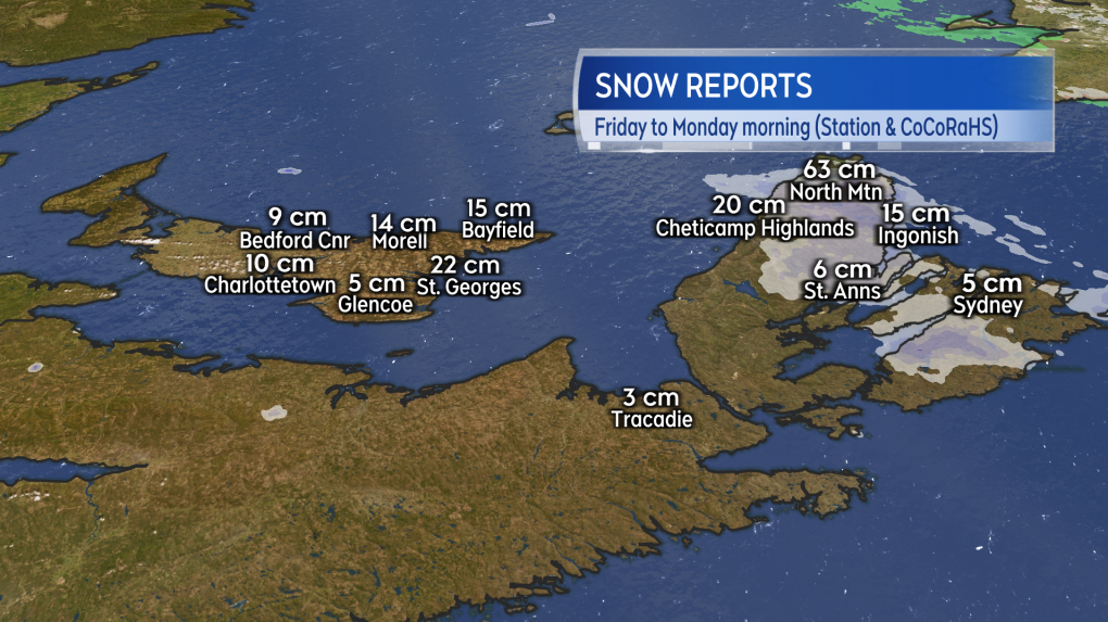
A weather station located at North Mountain in the Cape Breton Highlands reported at increase in snow-on-ground of 63 cm, or more than two feet. Other automated weather stations in Inverness and Victoria counties reported snow increases of 10-to-20 cm Sunday into early Monday afternoon.
It is common to see the snow accumulation increase significantly with the increased elevation of the Cape Breton Highlands. The rising topography allows for more lift in the atmosphere which then increases the amount of snow that falls. This is especially true when the wind direction is from the west or northwest due to additional moisture being drawn off the Gulf of St. Lawrence in that wind.
Bands of snow and snow squalls also impacted eastern Prince Edward Island and the North Shore of mainland Nova Scotia. Snow reports total more than 15 cm in parts of Kings County, P.E.I. There are few reports available from the North Shore of Nova Scotia but periods of poor visibility in localized areas were likely Sunday into Monday as the high wind created blowing and drifting snow.
 Snow total reports Friday through Monday morning for eastern areas of the Maritimes. (Source: CTV News Atlantic)
Warnings and improvement
As of early Monday afternoon, a Winter Storm Warning remained in effect for Inverness and Victoria counties, Kings County and the Magdalen Islands. The warnings call for another two-to-four cm of snow for the Magdalens and Prince Edward Island, another 10-to-20 cm of snow for parts of Inverness and Victoria counties and up to another 50 cm in the highest elevations of the Cape Breton Highlands.
The falling snow is still accompanied by a northwest wind occasionally gusting to 70 km/h.
Conditions in those areas are expected to improve Monday evening and night as the wind diminishes. All those areas, along with much of the Maritimes, can expect periods of lighter snow and flurries on Tuesday.
Cold continues
A seasonal round of colder winter air has settled into the Maritimes. The cold will through much of this week but will moderate slightly by Friday.
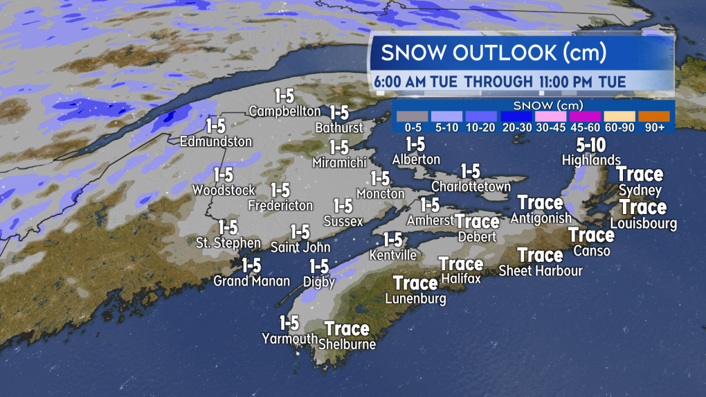
Lighter snow and flurries will be present across the Maritimes on Tuesday. In most cases the snow is expected to range between trace amounts up to five centimetres.
 Flurries and light snow expected for the Maritimes on Tuesday. (Source: CTV News Atlantic)
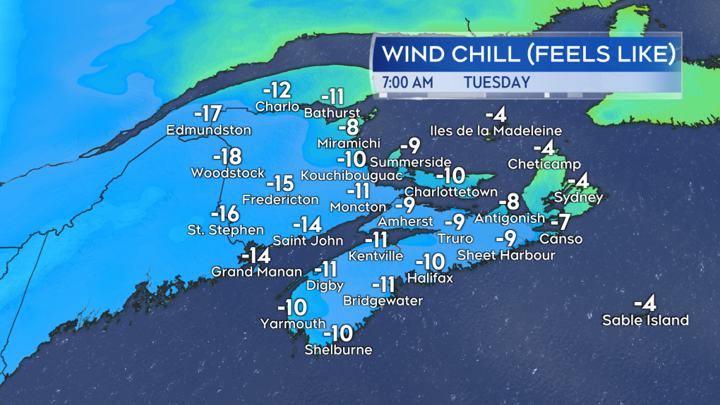
There will be a breezy northwest for Tuesday with gusts of 20-to-40 km/h. Taking into account the wind chill, much of the Maritimes will start the day with “feels like” temperatures of -9 C to -18 C.
 While the wind comes down for Tuesday a breeze present will still give the colder, winter air a bit of a bite. (Source: CTV News Atlantic)
In the longer range outlook, a winter storm is expected to develop on the U.S. eastern seaboard Friday into Saturday. While it’s too early to tell if it will directly impact the Maritimes next weekend, if it does come close enough it will bring our next chance of a more widespread, significant snowfall to the region.
CTVNews.ca Top Stories

Trump is open to using 'economic force' to acquire Canada; Trudeau responds
Prime Minister Justin Trudeau said 'there isn’t a snowball’s chance in hell that Canada would become part of the United States,' on the same day U.S. president-elect Donald Trump declared that he’s open to using 'economic force' to acquire Canada.
Los Angeles residents flee wildfire as fierce winds gain strength
Firefighters scrambled to corral a fast-moving wildfire in the Los Angeles hillsides dotted with celebrity homes as a potentially 'life-threatening, destructive' windstorm hit Southern California on Tuesday, fanning the blaze seen for miles while roads were clogged with cars as residents tried to flee.
Liberal leadership hopeful Frank Baylis noncommittal on eliminating consumer carbon tax
Liberal leadership hopeful Frank Baylis says eliminating the consumer carbon tax alone will not 'solve the affordability issue for Canadians.'
A B.C. mom's real-life nightmare and the search to find her trafficked daughter
A Vancouver island mom shares the story of what happened to her teenaged daughter – and a warning for other parents about sex trafficking.
Canadian naval vessel shadowed by Chinese war ship in the East China Sea
CTV National News is on board the HMCS Ottawa, embedded with Canadian Navy personnel and currently documenting their work in the East China Sea – a region where China is increasingly flexing its maritime muscle. This is the first of a series of dispatches from the ship.
Patient dies in waiting room at Winnipeg hospital
An investigation is underway after a patient waiting for care died in the waiting room at a Winnipeg hospital Tuesday morning.
Limit coffee-drinking to this time window to lower early death risk, study suggests
Drinking coffee has repeatedly been linked with better heart health and prolonged life. But the benefits of coffee consumption could depend on when you drink it, new research has found.
B.C. 'childbirth activist' charged with manslaughter after newborn's death
A British Columbia woman who was under investigation for offering unauthorized midwifery services is now charged with manslaughter following the death of a newborn baby early last year.
Man who exploded Tesla Cybertruck outside Trump hotel in Las Vegas used generative AI, police say
The highly decorated soldier who exploded a Tesla Cybertruck outside the Trump hotel in Las Vegas used generative AI including ChatGPT to help plan the attack, Las Vegas police said Tuesday.


