Clearing and cooler Friday in the Maritimes, possible aurora sightings?
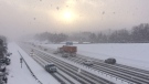
Broken cloud and a few spotty showers start Friday evening followed by a clearing trend that leaves just some patchy cloud around by midnight. During the overnight hours some returning cloud off the Gulf of St. Lawrence is expected for southeastern New Brunswick, the North Shore of Nova Scotia, and Prince Edward Island. Low temperatures for the region tonight come down into the low-to-mid single digits for most.
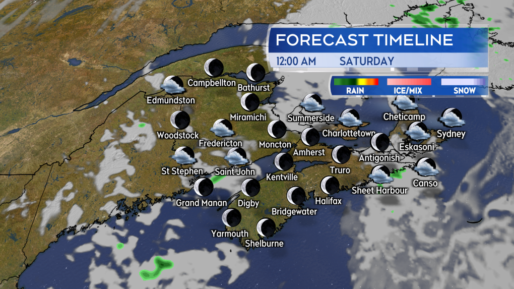 Partial clearing of cloud and spotty showers moving through Friday evening for the Maritimes. (Source: CTV News Atlantic)
Temperatures in the northwestern area of New Brunswick could fall between zero and two degrees by early Saturday morning, giving that part of the Maritimes the greatest risk of frost. Frost advisories continue for the same areas as the last couple of nights. Gardeners in the valleys of southern New Brunswick and valleys in areas of Nova Scotia inland around the Minas Basin and into Cumberland Colchester could have temperatures cool to near 4 C tonight. There is a lower, but not non-existent, chance of patchy frost there. The Cape Breton Highlands are also expected to fall to lows near or just below 4 C.
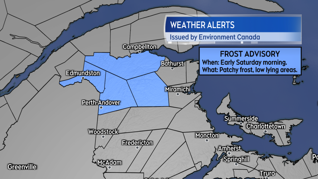 Frost Advisories continue for northwestern areas of New Brunswick. (Source: CTV News Atlantic)
Aurora forecast
A moderate geomagnetic storm (G2) is still forecast for Friday night by the Space Weather Prediction Center. In the past a moderate level event has been accompanied by glimpses of the aurora in parts of the Maritimes. It should be noted a moderate event will not come close to generating the aurora display created by the severe geomagnetic storm earlier this month.
Areas of the Maritimes that have a higher chance of glimpsing the aurora tonight are northern New Brunswick and Prince Edward Island per the aurora forecast from the University of Alaska Fairbanks. A faint showing near the northern horizon would be most likely. Standard night sky viewing tips include getting away from city lights and finding as much of an unobstructed view of the northern horizon as possible.
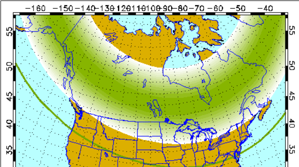 The aurora forecast for Friday night. (Source: University of Alaska Fairbanks)
Sky conditions around midnight for the Maritimes include some patchy cloud.
Sailing through the weekend
A northerly wind will keep the region a touch cooler for the weekend. Broken cloud is expected for most areas on Saturday accompanied by a low chance of showers for any given area, a 20-to-30% per cent chance. The chance of showers on Saturday is higher on the South Shore of Nova Scotia. Most high temperatures will be in the low-to-mid teens except high-teens and a few near 20 in western New Brunswick.
A decent forecast for those spectating the SailGP Halifax event. Just keep in mind being down by the waterfront can be cooler in a breezy wind.
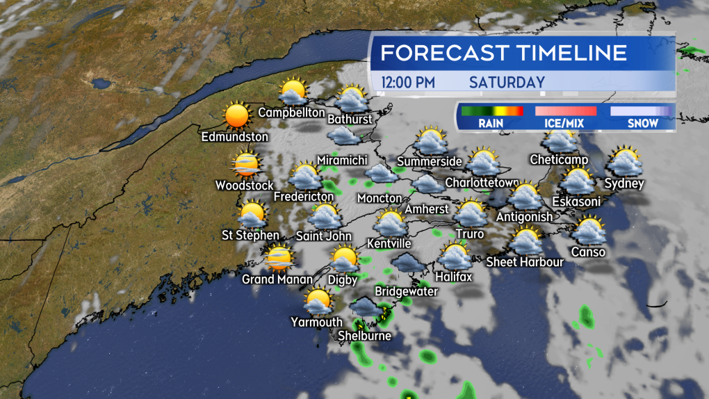 Broken sun and cloud on Saturday. A cooler northerly breeze and a chance of some very spotty showers. (Source: CTV News Atlantic)
An ocean low-pressure system moves between Sable Island and the south coast of Newfoundland Sunday. The system bringing cloudier conditions to southeastern New Brunswick, Nova Scotia, and Prince Edward Island. Showers are expected to develop for those areas through the day. Due to the cloud and showers high temperatures for those areas will mostly be in the low-to-mid teens.
There is not a great forecast for spectators of SailGP on Sunday. Be prepared for showers and a more blustery north wind making it feel cooler than Saturday.
Any areas with fair weather on Sunday? Communities in northern and western New Brunswick are, so far, expected to remain out of most of the cloud and shower chances. Some of those areas could have high temperatures that reach the low-twenties.
Shopping Trends
The Shopping Trends team is independent of the journalists at CTV News. We may earn a commission when you use our links to shop. Read about us.


CTVNews.ca Top Stories

Southern California wildfire destroys many structures; governor declares state of emergency
A wildfire whipped up by extreme winds swept through a Los Angeles hillside dotted with celebrity residences Tuesday, burning homes and forcing the evacuation of tens of thousands of people.
Trump is open to using 'economic force' to acquire Canada; Trudeau responds
Prime Minister Justin Trudeau said 'there isn’t a snowball’s chance in hell that Canada would become part of the United States,' on the same day U.S. president-elect Donald Trump declared that he’s open to using 'economic force' to acquire Canada.
A B.C. mom's real-life nightmare and the search to find her trafficked daughter
A Vancouver island mom shares the story of what happened to her teenaged daughter – and a warning for other parents about sex trafficking.
Liberal leadership hopeful Frank Baylis noncommittal on eliminating consumer carbon tax
Liberal leadership hopeful Frank Baylis says eliminating the consumer carbon tax alone will not 'solve the affordability issue for Canadians.'
Canadian naval vessel shadowed by Chinese war ship in the East China Sea
CTV National News is on board the HMCS Ottawa, embedded with Canadian Navy personnel and currently documenting their work in the East China Sea – a region where China is increasingly flexing its maritime muscle. This is the first of a series of dispatches from the ship.
Patient dies in waiting room at Winnipeg hospital
An investigation is underway after a patient waiting for care died in the waiting room at a Winnipeg hospital Tuesday morning.
Limit coffee-drinking to this time window to lower early death risk, study suggests
Drinking coffee has repeatedly been linked with better heart health and prolonged life. But the benefits of coffee consumption could depend on when you drink it, new research has found.
B.C. 'childbirth activist' charged with manslaughter after newborn's death
A British Columbia woman who was under investigation for offering unauthorized midwifery services is now charged with manslaughter following the death of a newborn baby early last year.
Man who exploded Tesla Cybertruck outside Trump hotel in Las Vegas used generative AI, police say
The highly decorated soldier who exploded a Tesla Cybertruck outside the Trump hotel in Las Vegas used generative AI including ChatGPT to help plan the attack, Las Vegas police said Tuesday.
Toronto
-

Stabbing in North York leaves man with serious injuries
A stabbing in North York has left a man in his 50s seriously injured, Toronto police say.
-
Ontario launching rebates for energy efficient home renovations and upgrades
Ontario is introducing two new energy efficiency programs, including one offering rebates for certain home improvements.
-
3 people charged in shooting death of Quebec man near Woodbine Beach
Three people have been arrested in connection with a shooting near Woodbine Beach last summer that left a 21-year-old Quebec man dead.
Calgary
-

'Oh, it's concerning': Albertans react to Trump's comments on using 'economic force' to acquire Canada
Donald Trump's latest comments on Canada becoming the 51st state caught many Albertans off guard Tuesday, after the U.S. president-elect said he wouldn't use military power but was considering using economic force to make it happen.
-
Calgary city council receives fourth straight pay raise
Calgary city councillors are enjoying another pay bump, marking the fourth consecutive year of salary increases. As of Jan. 1, the mayor and councillors received a 3.07 per cent raise, bringing the total increase since 2022 to 9.5 per cent.
-
Parachute was not deployed in fatal southern Alberta glider crash: TSB
An investigation into a fatal glider crash in southern Alberta last year confirmed the pilot managed to get out of his aircraft, but his parachute failed to open.
Edmonton
-

Alberta business braces for looming U.S. tariffs, embraces potential opportunities because of them
While Alberta's trading future with the United States is uncertain given the imminent threat of punishing tariffs promised by incoming President Donald Trump, business leaders say there is reason for optimism the province could avoid extensive blowback given the importance of energy to Canada's neighbouring global superpower.
-
Oilers shut out Bruins in Boston for fourth win in a row
Adam Henrique scored twice, Stuart Skinner made 26 saves and the Edmonton Oilers won their fourth straight game, beating the Bruins 4-0 on Tuesday in Boston.
-
'It's really exhausting': What 1 councillor says could speed up Edmonton’s construction troubles
City Councillor Andrew Knack is looking for solutions to make the city’s construction in the west end more bearable for drivers.
Montreal
-

Seniors forced to leave Hochelaga-Maisonneuve retirement home early amid closure controversy
Seniors forced to leave Hochelaga-Maisonneuve retirement home early amid closure controversy
-
Quebec woman charged after allegedly abandoning newborn outside
A 38-year-old woman was charged after allegedly abandoning her newborn shortly after giving birth outside in Trois-Rivières on New Year's Day.
-
Quebecer who murdered partner, 2 children serving life sentence in men's prison
A Quebecer convicted of killing her spouse and two children is now serving a life sentence in a men's prison.
Ottawa
-

Homeless man found 'frozen to death' in downtown Ottawa, councillor says
Somerset ward councillor Ariel Troster says she's "devastated" after a man sleeping in the streets of downtown Ottawa was found "frozen to death" on Monday.
-
Trump is open to using 'economic force' to acquire Canada; Trudeau responds
Prime Minister Justin Trudeau said 'there isn’t a snowball’s chance in hell that Canada would become part of the United States,' on the same day U.S. president-elect Donald Trump declared that he’s open to using 'economic force' to acquire Canada.
-
Train vs. car: How long does it take to get from Limebank to Rideau?
It was another big day for passengers riding the new north-south LRT and with many looking to cut down on their commute CTV News Ottawa wanted to see if it’s faster to get from the south end to downtown by car or by train.
London
-

Second-degree murder charge laid in connection to suspicious death in north London
One person is dead and one person is facing a second-degree murder charge as London police investigate a suspicious death.
-
Why this historic London farmhouse might have an industrial future
An old farmhouse in southeast London could become part of a new industrial subdivision after a committee endorsed recommendations to grant it heritage protection.
-
'He was walking down the middle of the train tracks': Minor injuries after person struck by train in London, Ont.
A man is lucky to be alive after being hit by a train Tuesday morning in London, Ont. Around 7:30 a.m. a train came to a halt just east of Third St. after blasting its horn.
Barrie
-
Winter weather travel advisory issued for Simcoe County
Environment Canada has issued a weather advisory for parts of central Ontario.
-
Police warn about ‘aggressive text scam’ circulating locally
The Barrie police fraud unit is warning residents about an “aggressive text messaging scam” it says is circulating locally.
-
Suspect sought after overnight Midland gas station robbery
Police are searching for a suspect wanted in connection to a robbery at a Midland gas station.
Northern Ontario
-

Fatal crash between pickup, train in northern Ontario
The driver of a pickup truck has died following a collision with a train in northern Ontario on Tuesday morning.
-
Northeastern Ont. police lay 139 impaired driving charges in six weeks
Efforts to reduce impaired driving in northeastern Ontario appear to be working in some communities, but are still high as provincial police release results of their Holiday season sobriety checks.
-
Sault man charged in weekend stabbing
A 26-year-old man from Sault Ste. Marie has been charged with aggravated assault and assault with a weapon following a stabbing in the city over the weekend.
Kitchener
-

New details released in case against admitted doula defrauder in Ontario
A woman, who previously admitted to faking pregnancies and defrauding numerous doulas, has pleaded guilty again to similar crimes, committed while serving her sentence on the original set of charges.
-
Unsafe car pulled off the road in Waterloo, driver charged
The Waterloo Regional Police Service has shared details of an unusual traffic stop in Waterloo.
-
To amalgamate or not? Brant County and Brantford mayors pick sides
The mayors of Brant County and Brantford are at odds over the idea of amalgamation.
Windsor
-

Police seize $20,000 in drugs, arrest employee at downtown magic mushroom shop
Windsor police seized $20,570 in illegal drugs and charged one individual after a raid at a downtown Windsor psilocybin dispensary on Monday afternoon.
-
Help needed after Wings Rehab Centre changes volunteer protocols amid avian flu concerns
In a post online, Wings Rehab indicated that effective this week, volunteers under the age of 18 are no longer permitted to assist at the animal rehabilitation facility, and that all adult volunteers are now required to have a current flu vaccination until further notice.
-
Detroit Lions acknowledging Windsor fans
The Lions-themed drone show will start at 7 p.m. on Jan. 10 and feature about 400 drones in the sky over the festival plaza and Detroit River.
Winnipeg
-

Patient dies in waiting room at Winnipeg hospital
An investigation is underway after a patient waiting for care died in the waiting room at a Winnipeg hospital Tuesday morning.
-
Manitoba regulator orders hike in auto premiums, calls for action on brain injuries
Manitobans will soon be paying more for basic automobile insurance.
-
'Unacceptable': Removal of beaver dam in Manitoba community sends surge downstream
The removal of a beaver dam in a rural Manitoba community is having some unintended consequences, sending a small flood downstream, catching residents off-guard.
Regina
-

Saskatchewan's teacher/student ratio becomes topic of debate as opposition sounds alarm
As those across the province await the verdict from binding arbitration between the province and the Sask. Teachers Federation (STF) – the Official Opposition is raising alarms over the teacher student ratio.
-
'Accessibility is the key': Breast cancer screening bus rolls into Weyburn
The Saskatchewan Cancer Agency's Breast Screening Bus has made its way to Weyburn, just in time for the beginning of new screening standards in the province.
-
Sask. man who withheld daughter to prevent COVID vaccination appeals conviction
A Saskatchewan father who was found guilty of withholding his daughter in contravention of a custody order is appealing his conviction.
Saskatoon
-
Crown challenges ruling in THC-impaired driving case where child was killed
The Crown has filed an appeal in a high-profile case involving the death of nine-year-old Baeleigh Maurice.
-
Chaos in Ottawa means uncertainty, opportunity for some Sask. industries
One day after the Prime Minister announced his intention to resign, observers are waiting to learn what a prorogued Parliament means for Saskatchewan.
-
These 90-year-old identical twins were born on a Saskatchewan farm, but grew to love the city
Rose Worona and Anne Skwarchuk were born in 1935 on a farm near Hafford. Now, they’re celebrating their 90th birthday together.
Vancouver
-

B.C. bird watcher’s ‘face feeder’ viral videos prompt caution from public health officials
An Abbotsford woman’s bird feeding videos are garnering millions of views online, but while the videos are going viral – public health experts are urging caution as Avian influenza still poses a risk to the region.
-
A B.C. mom's real-life nightmare and the search to find her trafficked daughter
A Vancouver island mom shares the story of what happened to her teenaged daughter – and a warning for other parents about sex trafficking.
-
4 generations on 1 lot: One family's creative response to B.C.’s housing crisis
A single lot in Delta, B.C., that used to be home to a single rancher built in the 80s is the site of four separate homes, housing four generations of the same family.
Vancouver Island
-

A B.C. mom's real-life nightmare and the search to find her trafficked daughter
A Vancouver island mom shares the story of what happened to her teenaged daughter – and a warning for other parents about sex trafficking.
-
'We're a rudderless ship': B.C. industry leaders bracing for Trump's impact
During a news conference Tuesday, U.S. President-elect Donald Trump didn't hold back in his message to Canada.
-
CRA to collect increased capital gains taxes despite proposed hike not being passed into law
The Canada Revenue Agency expects Canadians to adhere to a proposed capital gains tax increase – despite the fact the measure may never be passed into law.
Kelowna
-

1 hospitalized, residents displaced after Kelowna apartment fire
Firefighters knocked down a blaze on the third floor of a low-rise apartment building near downtown Kelowna Monday afternoon.
-
Lost skiers rescued off B.C. mountain
Search and rescue volunteers in B.C.’s Okanagan successfully reunited two skiers with their family Friday evening.
-
Charges laid after child porn investigation that 'spanned several different countries,' Kelowna RCMP say
Police in Kelowna say an international investigation has led to child pornography charges against a 46-year-old man.


