Light snow in the Maritimes adds up off ocean water and in higher terrain
A stalled storm system near Newfoundland continues to bring snow into the Maritimes. Light for the most part, there are areas where the snow is expected to total higher over the next 48 hours as it becomes enhanced by either coming in off the ocean or occurring in higher terrain.
Snowy spots to watch
A Snowfall Warning remains in effect for northern Inverness County, N.S. Through Thursday morning snow amounts of 20-to-30 cm are possible in parts of the Cape Breton Highlands. Lower elevations could see spots of snow ranging five-to-15 cm.
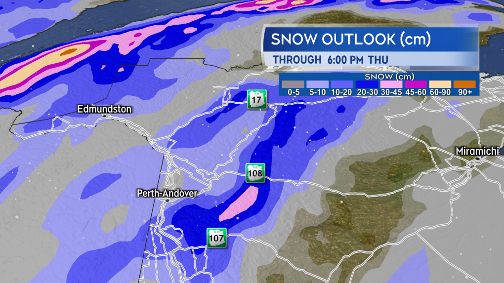
The mountainous terrain in New Brunswick from Carleton County north to Restigouche County could pick up 10-to-20 cm of snow through Thursday. Caution should be taken on any of the roadway routes that climb into higher terrain through this area. Roads could become snow covered and slippery.
 Snow amounts in some of the highest terrain in northwestern New Brunswick could approach 20 centimetres through Thursday. (Source: CTV News Atlantic)
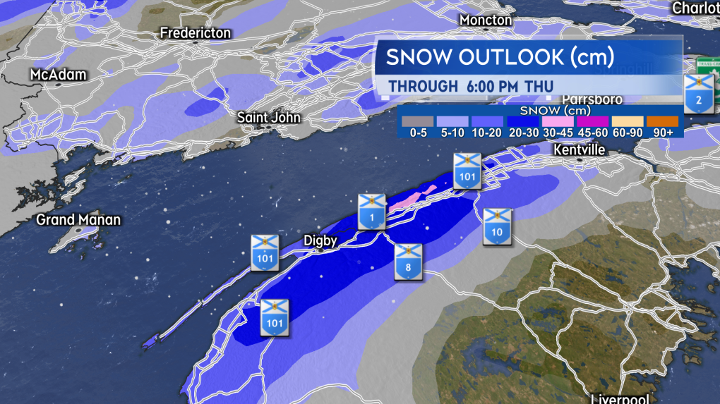
The Annapolis Valley and Digby County of Nova Scotia could also pick up varied snow totals of five-to-20 cm over the next 48 hours. Guidance for the higher amounts starts near the Greenwood area in the Valley and extends towards Meteghan in Digby County. The higher snow totals are most likely in hilly terrain. It is possible that five-to-10 cm of snow falls Wednesday evening and night, with another five-to-10 cm possible on Thursday.
 Snow will intensity off the Bay of Fundy for parts of southwestern Nova Scotia Wednesday evening into Thursday. Localized totals of five-to-20 centimetres possible. (Source: CTV News Atlantic)
Breaking free of the pattern
A ridge in the jet stream centred over the North Atlantic has prevented the Newfoundland storm from clearing to the east. The block has been breaking down over the last 24 hours and will allow for the storm to finally move east Friday into Saturday. Flurries will become more spotty in coverage on Friday.
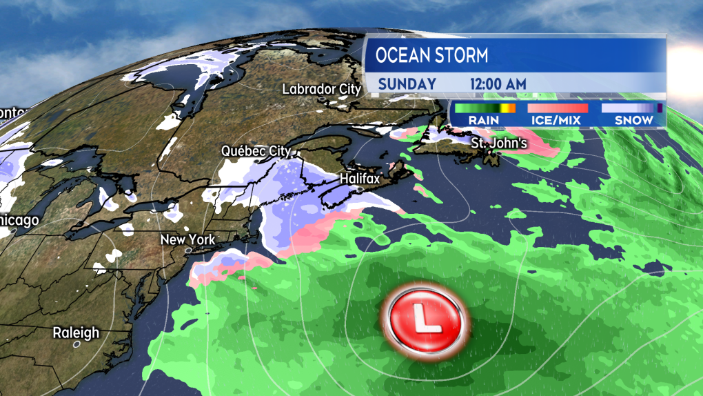
Another storm system strengthens off the U.S. eastern seaboard on Saturday. Current indications are for the storm to hold far enough south and east of the Maritimes to only have a marginal influence on our weather. A round of lighter snow and flurries may develop Saturday evening and night. The snow diminishes to scattered flurries on Sunday.
 Current indications are for an ocean storm to hold far enough south and east of the Maritimes this weekend to minimize impacts from it. (Source: CTV News Atlantic)
I recommend keeping tabs on the weekend forecast. Should the storm come in closer to the region than is currently expected, it would increase the amount of snow the Maritimes can expect. Unlike the stalled storm near Newfoundland, this second storm system is expected to exit out into the North Atlantic.
CTVNews.ca Top Stories

Canada could impose tariffs on U.S. steel, orange juice in response to Trump threat
Canadian officials are narrowing a list of American products to target in the event the federal government must respond to U.S. tariffs on Canadian goods, CTV News has confirmed.
Convicted Jan. 6 rioter arrested as fugitive in Whistler, B.C.
An American citizen convicted of participating in the Jan. 6, 2021, riot on Capitol Hill who said he was seeking asylum in Canada has been arrested as a "fugitive from U.S. justice," according to authorities.
Can the U.S. really make Canada the 51st state?
Talk of Canada becoming the 51st American state has raised an existential question on this side of the border: Could it be done? Could the maple leaf make way to the stars and stripes? According to several experts, it may be possible, but not painless.
L.A. wildfires continue to devastate area, Canada prepared to offer expertise
A series of wildfires are searing through the Los Angeles area, forcing many to evacuate their homes. Here's everything that happened throughout Jan. 8.
'True when I said it, true today': former Canadian PM Harper pushes back against Trump on social media
Former Canadian Prime Minister Stephen Harper doesn’t find president-elect Donald Trump’s jibes about Canada becoming the 51st U.S. state very amusing.
Ontario Premier Doug Ford says he is 'OK' after OPP vehicle he was in was 'sideswiped' in Highway 401 collision
Ontario Premier Doug Ford was uninjured after an OPP vehicle he was travelling in was involved in a collision on Highway 401 earlier today.
At least 60 University of Guelph students sick as 'cluster of illness' hits residence
The University of Guelph is dealing with what they are calling a ‘cluster of illness’ among students living in residence.
Energy minister 'committed' to consumer carbon tax as he considers Liberal leadership
Energy and Natural Resources Minister Jonathan Wilkinson says he would be 'committed' to the consumer carbon tax should he become Liberal leader and prime minister, despite the policy’s unpopularity.
New ranking suggests Canada passport among 'top 5 losers' in the world
A new global ranking may raise doubts about Canada's reputation of being open to other countries.


