Lunar halo graces weekend full 'cold' moon over the Maritimes
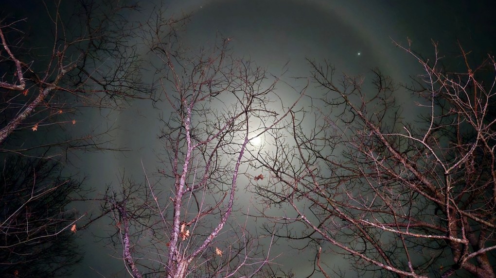 Lunar halo picture shared by Blake Haley. Take at Braeshore NS Sunday evening.
A lunar halo graced the night sky in the Maritimes this past weekend.
Lunar Halo
I received a number of fantastic pictures of a lunar halo this past weekend. Some of them were from Sunday, which was the day of the full “cold” moon. The cold moon is a name used to refer to the December full moon. Other names include The long nights moon and the moon before Yule.
 Lunar halo picture shared by Blake Haley. Take at Braeshore NS Sunday evening.
A lunar halo is created by the refraction of moonlight by tiny ice crystals that comprise thin, high cloud in the sky. This is the same process that creates a solar halo.
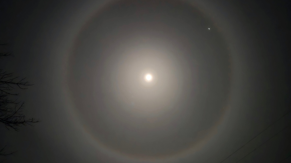 Lunar halo picture shared by Blake Haley. Taken at Braeshore NS Sunday evening.
A lunar halo can sometimes signal a change in the weather. The reason for that is high cloud often runs out ahead of lower, precipitation-bearing cloud associated with low pressure systems.
Tuesday rain and wind
On Tuesday a low-pressure system moving through northern Quebec sweeps a series of weather fronts across the Maritimes.
Rain arrives in western areas of New Brunswick and the southwest of Nova Scotia between 6 and 8 a.m. Tuesday. The rain then moves west to east across the region, clearing Cape Breton late Tuesday evening. Rainfall amounts of five-to-20 mm are expected for the Maritimes.
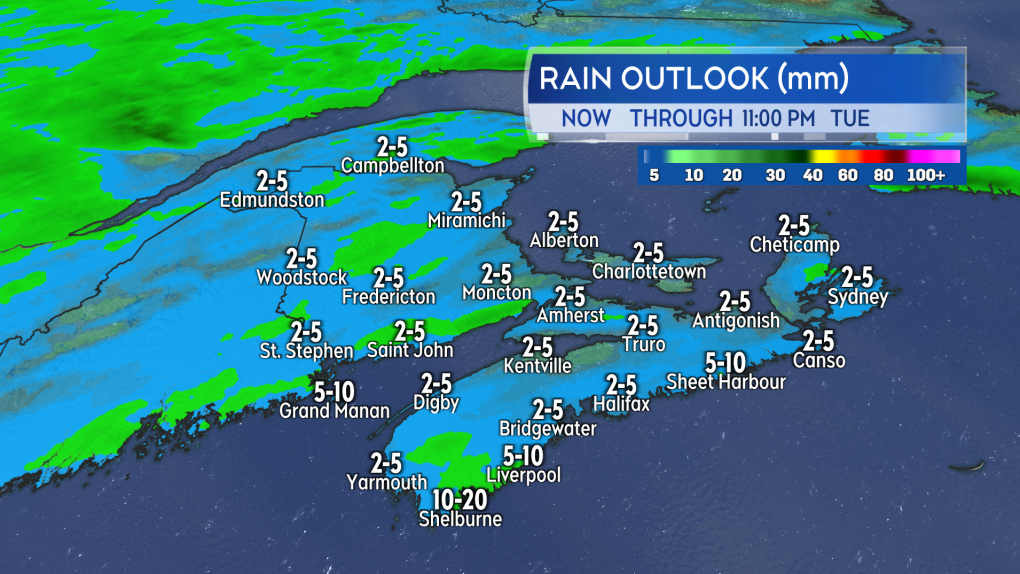 A light-to-moderate rain expected on Tuesday. (Source: CTV News Atlantic)
With temperatures warming into a range of seven-to-11 degrees on Tuesday, little snow is expected. Some surfaces may still be at freezing Tuesday morning when the rain begins and so could develop some initial ice. Areas in northern and western New Brunswick are at greatest risk of that.
Southerly winds with peak gusts of 40-to-60 km/h will accompany the rain. Coastal areas exposed to the south could experience gusts of 60-to-80 km/h. Due to the topography of the Cape Breton Highlands, northern Inverness County may reach gusts near 90 km/h late Tuesday afternoon and evening.
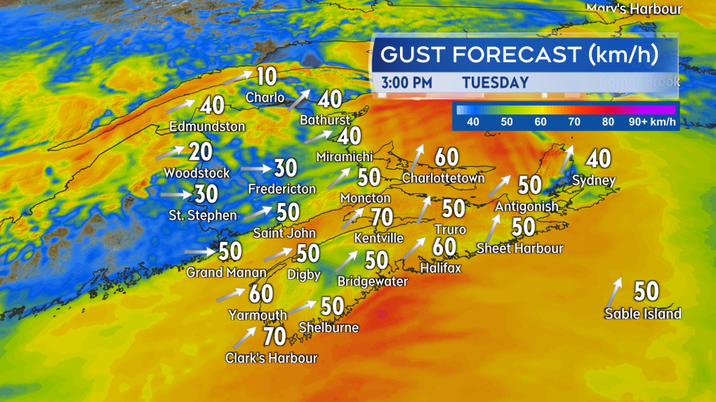 The rain will be accompanied by a gusty southerly wind. (Source: CTV News Atlantic)
Watching for Texas Low and possible snow
The next round of more inclement weather conditions is lined up for Thursday.
A low-pressure system originating from Texas is expected to move across the northeastern United States and into the Maritimes.
Snow looks most likely for northern and central areas of New Brunswick. A mix of snow and rain for southern New Brunswick, northern Nova Scotia, and Prince Edward Island. There will be mostly rain for Atlantic coastal Nova Scotia.
It’s a bit early to be narrowing down snow-rain amounts for specific areas. For those parts of the region that see mostly snow, general totals of five-to-15 cm wouldn’t been uncommon for this type of system. Snow-rain amounts for the region should come more into focus on Tuesday and Wednesday of this week.
CTVNews.ca Top Stories

LIVE UPDATES Trudeau considering his options as leader after Freeland quits cabinet, sources say
Chrystia Freeland, Canada's finance minister, said in an explosive letter published Monday morning that she will quit cabinet. Follow along for live updates.
Finance Minister Chrystia Freeland quits cabinet hours before economic update
Deputy Prime Minister and Finance Minister Chrystia Freeland has announced she's resigning from cabinet. In a letter to Prime Minister Justin Trudeau posted to social media, Freeland said this decision came after Trudeau offered her another position.
Amid Freeland resignation, Department of Finance begins embargoed reading of fall economic statement
Amid the news Finance Minister Chrystia Freeland has resigned from Prime Minister Justin Trudeau’s cabinet, the Department of Finance has begun handing out embargoed copies of the long-anticipated fall economic statement.
W5 Investigates Connecting the dots on a landlord scam: how clues revealed a prolific con artist at work
In part one of a three-part investigation, W5 correspondent Jon Woodward reveals how a convicted con artist bilked dozens of people in a landlord scam.
3 dead, others injured in shooting at private Christian school in Wisconsin
A student opened fire at a school Monday morning in Wisconsin, killing two people in the final week before Christmas break. The shooter also died, police said.
Travel risk: Which countries does Canada recommend avoiding?
Canadians planning to travel abroad over the holidays should take precautionary steps to ensure they're not unintentionally putting themselves in harm's way.
Canada Post operations to resume on Tuesday, company says
Mail is set to begin moving again on Tuesday after a month-long strike by Canada Post employees comes to a close.
Jury delivers guilty verdicts for accused in Montreal-area triple homicide trial
The accused in a triple homicide trial south of Montreal has been found guilty.
Second person facing charges in fatal boat crash in eastern Ontario on Victoria Day weekend
A second person is facing charges in connection to a boat crash that killed three people on Bobs Lake in eastern Ontario over the Victoria Day Long Weekend.


