Next round of snow for the Maritimes expected late Tuesday into Wednesday
It was a snowy start to the week for parts of southwestern Nova Scotia and New Brunswick as another low-pressure system moved off the continent and cut to the south.
Reports from Yarmouth and Shelburne counties in Nova Scotia ranged from several up to 15 cm of snow Monday morning.
A report from Grand Manan, N.B., also came in with 11 cm of snow. Only light snow was reported in other areas of the Maritimes Monday morning, though flurries did continue for parts of Cape Breton during the day as a cold, northerly wind continued over the Gulf of St. Lawrence.
The next weather system to effect the region is a strong low-pressure system that was centred over the midwestern United States Monday evening. While the centre of that system is forecast to track northward into southern Ontario and then Hudson Bay, the associated weather fronts push out to the U.S. eastern seaboard. Those fronts will help trigger the development of a second low-pressure system that will once again be carried by the jet stream to the south of the Maritimes.
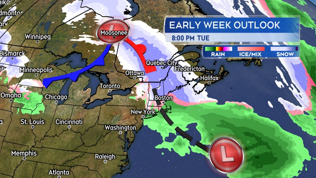 A trough of low pressure between two lows, one to our south and one near Hudson Bay, will be enough to bring snow the region late Tuesday into Wednesday.
That combination will put the Maritimes into a trough of low-pressure between the two systems late Tuesday into Wednesday. There will be enough moisture and lift in that trough to produce snow.
Snow is forecast to begin by Tuesday evening in western New Brunswick and southwestern Nova Scotia, with snow becoming more widespread overnight. Snow-covered roads along with still falling snow should be expected in western New Brunswick and western Nova Scotia Wednesday morning. Wednesday afternoon into evening will see that snow ease to scattered areas of flurries.
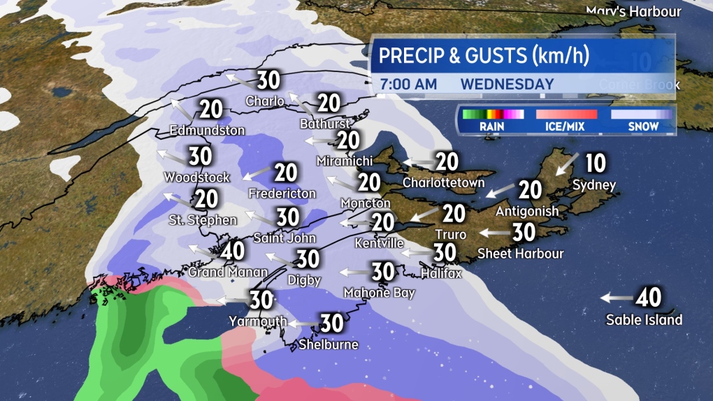 A snowy start to the day for at least western areas of the Maritimes on Wednesday. A breezy easterly wind will accompany the falling snow.
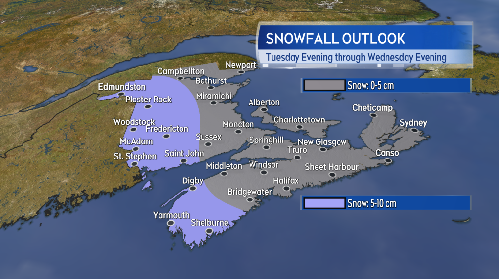
The snow is expected to accumulate the most in western areas of both New Brunswick and Nova Scotia. There is a widespread 5 to 10 cm expected, with possible pockets of 10 to 15 cm. Eastern New Brunswick, eastern Nova Scotia including Cape Breton, and Prince Edward Island will likely see a lighter snow or flurries from the system.
An easterly wind with gusts of 20 to 40 km/h will accompany the falling snow.
A second low-pressure system is forecast to move out of New England Thursday morning. The path of that low is expected to bring it closer to the southwest of Nova Scotia. More snow is forecast for the Maritimes from it and it may have a higher potential to bring in some amounts of 15 cm or more. That potential for a heavier snow is highest for Nova Scotia at the moment. Snow amounts for the Thursday system should come into focus by Tuesday evening.
Shopping Trends
The Shopping Trends team is independent of the journalists at CTV News. We may earn a commission when you use our links to shop. Read about us.


CTVNews.ca Top Stories

Trump threatens to try to take back the Panama Canal. Panama's president balks at the suggestion
Donald Trump suggested Sunday that his new administration could try to regain control of the Panama Canal that the United States “foolishly” ceded to its Central American ally, contending that shippers are charged “ridiculous” fees to pass through the vital transportation channel linking the Atlantic and Pacific Oceans.
Man handed 5th distracted driving charge for using cell phone on Hwy. 417 in Ottawa
An Ottawa driver was charged for using a cell phone behind the wheel on Sunday, the fifth time he has faced distracted driving charges.
Wrongfully convicted N.B. man has mixed feelings since exoneration
Robert Mailman, 76, was exonerated on Jan. 4 of a 1983 murder for which he and his friend Walter Gillespie served lengthy prison terms.
Can the Governor General do what Pierre Poilievre is asking? This expert says no
A historically difficult week for Prime Minister Justin Trudeau and his Liberal government ended with a renewed push from Conservative Leader Pierre Poilievre to topple this government – this time in the form a letter to the Governor General.
opinion
opinion Christmas movies for people who don't like Christmas movies
The holidays can bring up a whole gamut of emotions, not just love and goodwill. So CTV film critic Richard Crouse offers up a list of Christmas movies for people who might not enjoy traditional Christmas movies.
More than 7,000 Jeep SUVs recalled in Canada over camera display concern
A software issue potentially affecting the rearview camera display in select Jeep Wagoneer and Grand Cherokee models has prompted a recall of more than 7,000 vehicles.
'I'm still thinking pinch me': lost puppy reunited with family after five years
After almost five years of searching and never giving up hope, the Tuffin family received the best Christmas gift they could have hoped for: being reunited with their long-lost puppy.
10 hospitalized after carbon monoxide poisoning in Ottawa's east end
The Ottawa Police Service says ten people were taken to hospital, with one of them in life-threatening condition, after being exposed to carbon monoxide in the neighbourhood of Vanier on Sunday morning.
New York City police apprehend suspect in the death of a woman found on fire in a subway car
New York City police announced Sunday they have in custody a “person of interest” in the early morning death of a woman who they believe may have fallen asleep on a stationary subway train before being intentionally lit on fire by a man she didn't know.
Toronto
-
Snowfall coming to several parts of the GTA on Monday: Environment Canada
Monday’s commute to and from work could be a snowy one for people throughout the GTA.
-
Police identify man who died after being stabbed in Toronto’s Corso Italia area, man charged with second-degree murder
Toronto police have identified a man who died following after being stabbed during a “protracted altercation” in Toronto’s Corso Italia area over the weekend.
-
1 injured in Rexdale jewelry store robbery
One person has been injured after an unknown number of suspects drove a vehicle into the front of a jewelry store in north Etobicoke and stole merchandise.
Calgary
-

Police looking for driver involved in pedestrian collision in downtown Calgary.
One person is in hospital after being struck by an SUV in downtown Calgary early Saturday morning,
-
It was Grandma, in the cafe with a Scrabble tile: Game cafes are big holiday business
It’s the holidays, which means for many across the Prairies, there’s no better time to get locked in a dungeon with a dragon.
-
Calgary Firefighters Toy Association throws a Christmas party for thousands of kids at Telus Centre
The Calgary Firefighters Toy Association threw a Christmas party Sunday afternoon for about 4,000 kids at the Telus Convention Centre.
Edmonton
-

'There’s no support': Domestic abuse survivor shares difficulties leaving her relationship
An Edmonton woman who tried to flee an abusive relationship ended up back where she started in part due to a lack of shelter space.
-
opinion
opinion Christmas movies for people who don't like Christmas movies
The holidays can bring up a whole gamut of emotions, not just love and goodwill. So CTV film critic Richard Crouse offers up a list of Christmas movies for people who might not enjoy traditional Christmas movies.
-
AMA fundraiser for Alberta food banks nets more than $322,000
A provincial fundraiser this year has gathered its highest annual amount ever.
Montreal
-

Jewellery store robbery in Parc-Extension under investigation
Montreal police (SPVM) are investigating a robbery that occurred at a Jewellery store robbery in Parc-Extension under investigation store in the Parc-Extension neighborhood on Saturday evening.
-
Workers helping the homeless in Montreal feel powerless as crisis deepens
Social workers on the front lines of homelessness in Montreal say they feel increasingly powerless as more people find themselves forced to live in tents during the winter.
-
Here's how you can watch CTV News Montreal at Six on Sundays during the NFL season
With CTV broadcasting NFL football games on Sundays this season, CTV News Montreal at Six will be broadcasting live on our website and the CTV News App.
Ottawa
-

10 hospitalized after carbon monoxide poisoning in Ottawa's east end
The Ottawa Police Service says ten people were taken to hospital, with one of them in life-threatening condition, after being exposed to carbon monoxide in the neighbourhood of Vanier on Sunday morning.
-
WINTER TRAVEL ADVISORY
WINTER TRAVEL ADVISORY 10-20 cm of snow expected in Ottawa starting Monday
Environment Canada has issued a winter weather travel advisory for Ottawa with 10-20 centimetres of snow in the forecast on Monday.
-
What's open and closed in Ottawa over the holidays
CTVNewsOttawa.ca takes a look at what's open and closed over the Christmas and New Year's holidays this year.
London
-

'Ford Field Experience in London': Detroit Lions host tailgate and watch party at Canada Life Place
It was a sea of Silver and Honolulu Blue on Dundas Place in London, Ont. as over 3,000 fans gathered for a Lions game on Sunday.
-
Standoff in Seaforth at the centre of SIU investigation
Following a standoff in Seaforth on Friday, the province’s police watch dog is investigating an officer’s conduct.
-
Driver charged following collision with hydro box that plunged Listowel into darkness Saturday
OPP and hydro crews were on scene on Hutton Street for much of the day working to clear the collision, and get power restored to the town.
Barrie
-

Residents startled by blue flashes in the sky during power outage in Barrie
A power outage on Saturday night left over a thousand Barrie homes in the dark.
-
Police allege man failed to steal car after finding out it was standard
Barrie Police are looking for a male suspect involved in an alleged car theft attempt that ended up being unsuccessful.
-
Sauna fire creates cloud of smoke over part of Barrie's south end
Dark clouds of smoke loomed over Barrie residents from a nearby parking lot in the south end.
Northern Ontario
-

OPP investigating fatal collision Saturday in northwest Ontario
Ontario Provincial Police are investigating a fatal collision that occurred on Saturday evening in northwestern Ontario.
-
Can the Governor General do what Pierre Poilievre is asking? This expert says no
A historically difficult week for Prime Minister Justin Trudeau and his Liberal government ended with a renewed push from Conservative Leader Pierre Poilievre to topple this government – this time in the form a letter to the Governor General.
-
Northern Ont. man illegally killed three moose, one deer
A man from the northwestern Ontario community of Dinorwic has been found guilty of multiple hunting offences and fined $6,500, banned from hunting for five years and placed on probation for 18 months.
Kitchener
-

WR Grassroots Response expands support for displaced Ukrainians with new guest house in Centre Wellington
Displaced Ukrainians finding refuge in Ontario have a new haven thanks to Grassroots Response to the Ukrainian Crisis, a Waterloo Region-based not-for-profit.
-
Can the Governor General do what Pierre Poilievre is asking? This expert says no
A historically difficult week for Prime Minister Justin Trudeau and his Liberal government ended with a renewed push from Conservative Leader Pierre Poilievre to topple this government – this time in the form a letter to the Governor General.
-
Driver in Kitchener charged after going 180km/h in 70km/h zone
A G2 driver has been charged after going 110km over the speed limit in Kitchener Sunday morning.
Windsor
-

'Giving back': Kingsville store hands out free fresh groceries ahead of the holidays
Cars lined up outside of Cindy’s Home and Garden store in Kingsville on Sunday morning for the first Green Pick-up Holiday Food Drive-Thru.
-
Looking for a last minute stocking stuffer? This local fundraiser has the thing for you.
If you’re looking for a stocking stuffer idea, consider the Kiwanis Camp Lottery Calendar! It offers $14,000 worth of prizes, including a cash prize every month and a gift up for grabs every week throughout next year.
-
Annual Christmas dinner provides 2,000 meals to Windsor-Essex families
About 30 volunteer drivers toured the region on Saturday, delivering the prepared meals, which included turkey, gravy, stuffing, dinner rolls and vegetables.
Winnipeg
-

Minnesota-Manitoba border airport permanently shutting down after 70 years
An airport with a runway that spans across the Canada-U.S. border will close for good by the end of this week.
-
Manitoba man hopes to sell parts of unique, homemade musical instrument collection
Eighty-eight-year-old Lorne Collie has been making musical instruments for more than three decades, creations that dazzle for their unique materials as much as their sound.
-
Man attacks family with bear spray after vehicle collision: WPS
A Winnipeg man is facing several weapon-related charges after police said he attacked a family with bear spray.
Regina
-

'For the community, by the community': Regina's Sikh community helping fight food insecurity
Regina's Sikh community has been helping feed those less fortunate in Regina for over seven years.
-
Gathering held in Regina to recognize Winter Solstice
Regina's mâmawêyatitân centre held a day of gathering for the Winter Solstice on Saturday.
-
Canada's first sustainable Tim Hortons location to open in Regina this weekend
Canada’s first sustainable Tim Hortons opens in Regina this weekend. The restaurant, located in the city’s east end, features design and operating features that minimize environmental impact.
Saskatoon
-
Sask. woman dead following crash on Highway 5
A 69-year-old woman from the Humboldt area is dead after her SUV collided with a truck on Highway 5, according to police.
-
Sask. police investigating mischief incident after bomb report in school
Prince Albert police are investigating a mischief incident after a bomb report in a school Friday afternoon.
-
Prince Albert woman collects donations to make Christmas hampers for community
A Prince Albert woman is spreading holiday cheer by organizing Christmas hampers for those in need.
Vancouver
-

Second body recovered from site of B.C. landslide
The second resident of a home that was destroyed by a landslide in Lions Bay, B.C., last weekend was found dead Saturday, officials confirmed.
-
Boxes of Love brightens the season for families in need with holiday hampers
Hundreds of holiday hampers went out to low-income families across Metro Vancouver over the weekend as part of the annual Boxes of Love campaign.
-
Facing hometown Canucks 'a bit surreal' for Sharks rookie Celebrini
Macklin Celebrini grew up dreaming of playing NHL hockey at Rogers Arena. On Monday, that dream becomes a reality.
Vancouver Island
-

More strong winds hit parts of B.C.'s coast as record-high temperatures recorded
What has been a windy weekend for parts of B.C.’s coast continued Sunday as Environment Canada issued a fresh set of wind warnings.
-
Drug superlabs leave a toxic mess. Some say B.C.'s cleanup rules are a mess, too
As clandestine drug labs become larger and more complex, so does the toxic mess they leave behind and the tools required to clean them up, creating expensive and dangerous situations for both people and the environment.
-
Second body recovered from site of B.C. landslide
The second resident of a home that was destroyed by a landslide in Lions Bay, B.C., last weekend was found dead Saturday, officials confirmed.
Kelowna
-

Forfeited Hells Angels clubhouse in Kelowna, B.C., sold to the city
A former Hells Angels clubhouse that was seized by the British Columbia government in 2023 after years of fighting in court has been sold to the City of Kelowna.
-
Death of woman found in Kelowna's Waterfront Park in June deemed 'non-criminal in nature': RCMP
Police in Kelowna say a death they began investigating back in June has now been confirmed as "non-criminal in nature."
-
B.C. man sentenced for 'execution-style' murder of bystander in drug trade conflict
A B.C. man convicted of the "intentional and ruthless killing of a bystander" while acting as an enforcer in the drug trade has been sentenced for a second time in the slaying.


