Parts of the Maritimes left with 100 cm as epic snowfall eases on Monday
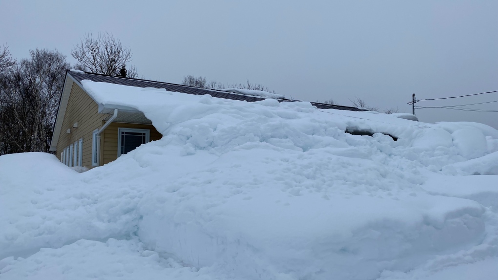
 Only a small part of a home in the Cape Breton Regional Municipality is visible on Feb. 5, 2024, after extreme amounts of snow fell in the area. (Kyle Moore/CTV Atlantic)
The weekend snowstorm of February 3 and 4 brought a record amount of snow down for parts of the Maritimes.
The Sydney Airport set records for daily snowfall on both February 3 with 41 cm and February 4 with 35 cm reported.
The Charlottetown Airport set a record for daily snowfall on a February 3 with 30 cm reported.
Halifax International Airport set a record for daily snowfall on a February 4 with 38 cm reported.
That is just a sampling of daily records. Other locations in eastern mainland Nova Scotia, Cape Breton, and Prince Edward Island almost assuredly set some daily record snow amounts for February 3 and 4.
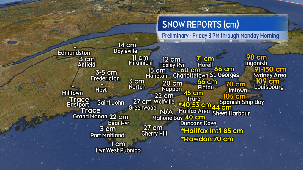
Overall snow totals range 40 to 70 cm across a large part of central and eastern Nova Scotia as well as central and eastern Prince Edward Island. A few reports of 100+ cm have come in from the volunteer observers of the Community Collaborative Rain, Hail, & Snow Network including 105 cm at Spanish Ship Bay and 150 cm at Sydney N.S.
 Preliminary and unofficial snow reports from the weekend snowstorm across for the Maritime provinces. (CTV/Kalin Mitchell)The gusty north wind that accompanied the days long snow created extensive blowing snow and drifts which can make accurate measurements of the total amount of snow very difficult. There is little doubt the overall snow totals that we saw this weekend rank high with some of the heavier historic snow events seen in the region.
A few that come to mind are the winter of 2014/2015, when a quick hitting series of storms brought snow totals of more than 80 cm in a matter of days to parts of Nova Scotia. White Juan in February of 2004 brought a widespread 60-90 cm to parts of Nova Scotia and Prince Edward Island with unofficial reports as high as 100 to 150 cm. The February blizzard of 1992 which left 160 cm of snow for Moncton and amounts around 70 cm in parts of Cape Breton.
The heaviest of the snow has passed. Remaining areas of lighter snow and flurries will continue to ease Monday night through Tuesday. Some further localized snow amounts of one-to-five centimetres possible in the light snow and flurries.
A gusty northerly wind continues to create areas of drifting snow. The wind will continue to diminish into Tuesday and any occurrences of drifting snow with it.
No further heavy snow is in the forecast for the remainder of the week. The next more widespread round of precipitation to arrive for the Maritimes is a mix of snow and rain next Sunday.
CTVNews.ca Top Stories

Trump threatens to try to take back the Panama Canal. Panama's president balks at the suggestion
Donald Trump suggested Sunday that his new administration could try to regain control of the Panama Canal that the United States “foolishly” ceded to its Central American ally, contending that shippers are charged “ridiculous” fees to pass through the vital transportation channel linking the Atlantic and Pacific Oceans.
Man handed 5th distracted driving charge for using cell phone on Hwy. 417 in Ottawa
An Ottawa driver was charged for using a cell phone behind the wheel on Sunday, the fifth time he has faced distracted driving charges.
Wrongfully convicted N.B. man has mixed feelings since exoneration
Robert Mailman, 76, was exonerated on Jan. 4 of a 1983 murder for which he and his friend Walter Gillespie served lengthy prison terms.
Can the Governor General do what Pierre Poilievre is asking? This expert says no
A historically difficult week for Prime Minister Justin Trudeau and his Liberal government ended with a renewed push from Conservative Leader Pierre Poilievre to topple this government – this time in the form a letter to the Governor General.
opinion Christmas movies for people who don't like Christmas movies
The holidays can bring up a whole gamut of emotions, not just love and goodwill. So CTV film critic Richard Crouse offers up a list of Christmas movies for people who might not enjoy traditional Christmas movies.
More than 7,000 Jeep SUVs recalled in Canada over camera display concern
A software issue potentially affecting the rearview camera display in select Jeep Wagoneer and Grand Cherokee models has prompted a recall of more than 7,000 vehicles.
'I'm still thinking pinch me': lost puppy reunited with family after five years
After almost five years of searching and never giving up hope, the Tuffin family received the best Christmas gift they could have hoped for: being reunited with their long-lost puppy.
10 hospitalized after carbon monoxide poisoning in Ottawa's east end
The Ottawa Police Service says ten people were taken to hospital, with one of them in life-threatening condition, after being exposed to carbon monoxide in the neighbourhood of Vanier on Sunday morning.
New York City police apprehend suspect in the death of a woman found on fire in a subway car
New York City police announced Sunday they have in custody a “person of interest” in the early morning death of a woman who they believe may have fallen asleep on a stationary subway train before being intentionally lit on fire by a man she didn't know.


