Maritime weather: Heavy rain, strong winds expected in some areas
Outlook
Caught between a storm centred over Quebec and high pressure to our east, the Maritimes is in store for more rain and stronger winds Wednesday evening into Thursday. A heavy winter rain brings a risk of localized flooding for some areas. A strong southerly wind is also expected to reach the warning criteria of gusts to 90 km/h for a large portion of the region. The system clears as a mix of rain and snow on Thursday with a sharp fall in temperatures back below freezing behind it.
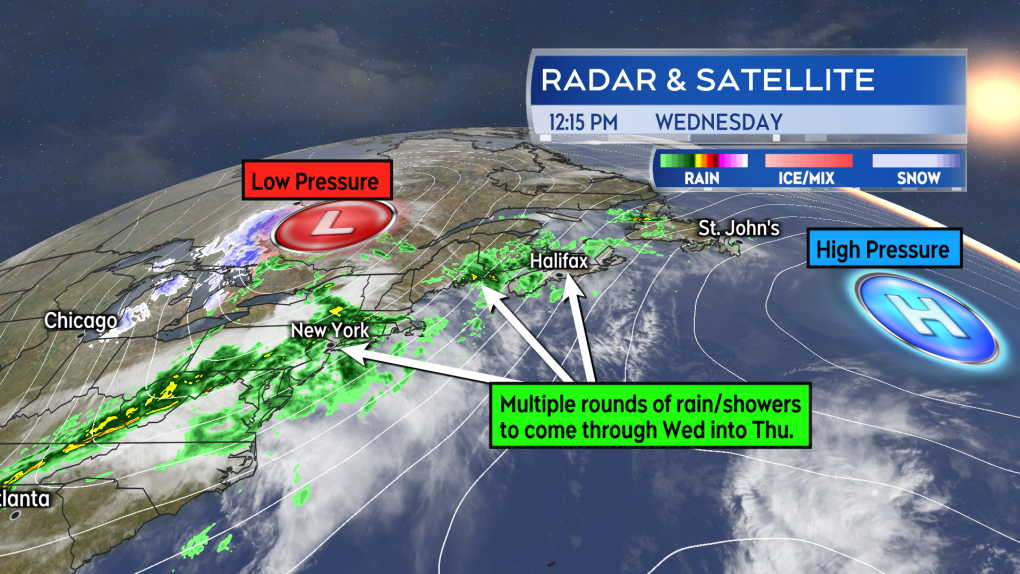 Multiple rounds of rain and showers are on the way up the eastern seaboard for the Maritimes Wednesday into Thursday.
New Brunswick
Already into rounds of rain and showers, some of the heaviest rain is set to arrive for southern areas of New Brunswick between 10 p.m. Wednesday and 4 a.m. Thursday. The highest risk of downpours will be centred near the Bay of Fundy coastline where the rain could total 60-to-120 mm. The province will see the rain flip back over to a brief period of snow early Thursday morning with that snow clearing before and by 7 a.m. The snow may be as much as one-to-five centimetres locally. Temperatures will fall quickly back below freezing for New Brunswick on Thursday and wet or slushy surfaces could become icy.
Rainfall warnings have been issued for much of New Brunswick, excluding the northern most counties of the province. Environment Canada is noting that snowmelt and a frozen ground could elevate the risk of localized flooding. The warnings broadly calls for 25-to-50 mm of rain, but 60-to-100 mm in southern areas of the province.
A wind warning is also in effect for the southern half of the province. A southerly wind is forecast to increase to reach gusts of 70-to-80 km/h, except up to 100 km/h over exposed areas Wednesday evening and night, then becoming northwest with gusts falling into a range of 40-to-70 km/h Thursday morning.
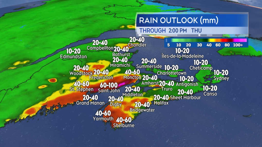 The heaviest rain is most likely in the southernmost areas of New Brunswick and the southwest of Nova Scotia.
Nova Scotia
Much like New Brunswick, Nova Scotia will get into a more persistent and heavy rain Wednesday night. That arrives in southwestern areas of the province Wednesday evening and moving eastward overnight. The most total rain is expected in Digby, Yarmouth, and Shelburne Counties with 50-to-80 mm possible. The rain turns to a brief period of snow Thursday morning with the mix clearing mainland Nova Scotia by 10 a.m. Thursday and Cape Breton by 2 p.m. Thursday. Up to a few centimetres of snow is possible. Temperatures will fall back to and below freezing through Thursday afternoon. Watch for any untreated, wet surfaces that may become icy.
A rainfall warning is posted for mainland Nova Scotia. The warning cautions of 25-to-50 mm of rain, with higher local amounts near 65 mm possible. There is a risk of “localized flooding in low-lying areas” and the warning says heavy downpours can cause flash floods and water pooling on roads. Cape Breton is not under the rainfall warning, with totals of 10-to-20 mm expected there.
The entire province is under a wind warning. The warning is valid Wednesday evening into Thursday morning for mainland Nova Scotia and Wednesday night into Thursday afternoon for Cape Breton. Southerly wind gusts up to 100 km/h are expected at times. Additional gusts up to 130 km/h are possible from Margaree Harbour to Bay St. Lawrence in Inverness, Cape Breton, Thursday morning and early Thursday afternoon.
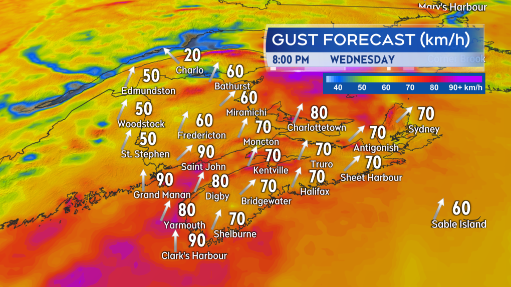 The strongest of the southerly wind gusts arrives in southwestern New Brunswick and southwestern Nova Scotia Wednesday evening.
Prince Edward Island and Magdalen Islands
Showers Wednesday afternoon will turn to rain for P.E.I. Wednesday night. The rain will turn to snow from 6 a.m. to 8 a.m. Thursday before clearing. As much as one-to-five centimetres of snow is expected to fall. Temperatures for P.E.I. will fall back to and below freezing by 2 p.m. Thursday. Icy spots could develop on untreated surfaces.
Prince County is under a rainfall warning. Up to 25 mm of rain is expected there. The rest of P.E.I. is generally expected to receive 10-to-20 mm of rain.
The province is under a wind warning. Southerly gusts are expected to reach near 90 km/h Wednesday night and Thursday morning. The wind will become northwest with gusts of 40-to-70 km/h for Thursday afternoon. The Magdalen Islands are also under a wind warning. The area is at risk of southerly gusts near 110 km/h overnight Wednesday and Thursday.
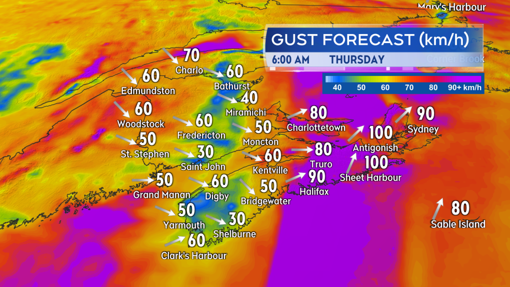 The strong wind gusts shift eastward Wednesday overnight. The Maritimes will see a northwest wind with gusts of 40-to-70 km/h by Thursday afternoon.
Shopping Trends
The Shopping Trends team is independent of the journalists at CTV News. We may earn a commission when you use our links to shop. Read about us.


CTVNews.ca Top Stories

Donald Trump says he urged Wayne Gretzky to run for prime minister in Christmas visit
U.S. president-elect Donald Trump says he told Canadian hockey legend Wayne Gretzky he should run for prime minister during a Christmas visit but adds that the athlete declined interest in politics.
Historical mysteries solved by science in 2024
This year, scientists were able to pull back the curtain on mysteries surrounding figures across history, both known and unknown, to reveal more about their unique stories.
King Charles III focuses Christmas message on healthcare workers in year marked by royal illnesses
King Charles III used his annual Christmas message Wednesday to hail the selflessness of those who have cared for him and the Princess of Wales this year, after both were diagnosed with cancer.
Mother-daughter duo pursuing university dreams at the same time
For one University of Windsor student, what is typically a chance to gain independence from her parents has become a chance to spend more time with her biggest cheerleader — her mom.
Thousands without power on Christmas as winds, rain continue in B.C. coastal areas
Thousands of people in British Columbia are without power on Christmas Day as ongoing rainfall and strong winds collapse power lines, disrupt travel and toss around holiday decorations.
Ho! Ho! HOLY that's cold! Montreal boogie boarder in Santa suit hits St. Lawrence waters
Montreal body surfer Carlos Hebert-Plante boogie boards all year round, and donned a Santa Claus suit to hit the water on Christmas Day in -14 degree Celsius weather.
Canadian activist accuses Hong Kong of meddling, but is proud of reward for arrest
A Vancouver-based activist is accusing Hong Kong authorities of meddling in Canada’s internal affairs after police in the Chinese territory issued a warrant for his arrest.
New York taxi driver hits 6 pedestrians, 3 taken to hospital, police say
A taxicab hit six pedestrians in midtown Manhattan on Wednesday, police said, with three people — including a 9-year-old boy — transported to hospitals for their injuries.
Azerbaijani airliner crashes in Kazakhstan, killing 38 with 29 survivors, officials say
An Azerbaijani airliner with 67 people onboard crashed Wednesday near the Kazakhstani city of Aktau, killing 38 people and leaving 29 survivors, a Kazakh official said.
Toronto
-

'A strong woman who never gave up': East Toronto neighbourhood shaken by death of unhoused resident
People in Toronto’s east end are shaken after a well-known unhoused woman from the community reportedly died over the weekend.
-
Man wanted for 2 unprovoked incidents in downtown Toronto on Christmas Eve
Toronto police are searching for a suspect who allegedly choked a female in downtown Toronto then threatened an employee at a business with a hammer.
-
1 person seriously injured in Scarborough stabbing
One person was taken to the hospital with serious, but non-life-threatening injuries following a stabbing on Dec. 25 in Scarborough, say paramedics.
Calgary
-
Solar burgers: How agrivoltaics is marrying food production with green energy
Jason Bradley spent 20 years of his career as ranch manager at a 50,000-acre grazing operation in west-central Alberta, so he understands why people react with skepticism to the idea of raising a herd of cattle on a working solar farm.
-
Lake Louise ice climber takes a scary fall, then carries on climbing ice
The sport of ice climbing is becoming more and more popular, but one man is lucky to be alive after a serious fall in Alberta’s back country.
-
First responders spend Christmas Eve circling Alberta Children’s Hospital in tribute to hospital staff and kids
More than a dozen emergency vehicles headed to Alberta Children’s Hospital Tuesday, but there was no disaster.
Edmonton
-

Alberta premier hopes for health reform payoff in 2025, regrets deferring tax cut
"It may have been better for Albertans if we'd implemented and then found a way to be able to pay for it."
-
Donald Trump says he urged Wayne Gretzky to run for prime minister in Christmas visit
U.S. president-elect Donald Trump says he told Canadian hockey legend Wayne Gretzky he should run for prime minister during a Christmas visit but adds that the athlete declined interest in politics.
-
Lake Louise ice climber takes a scary fall, then carries on climbing ice
The sport of ice climbing is becoming more and more popular, but one man is lucky to be alive after a serious fall in Alberta’s back country.
Montreal
-

Ho! Ho! HOLY that's cold! Montreal boogie boarder in Santa suit hits St. Lawrence waters
Montreal body surfer Carlos Hebert-Plante boogie boards all year round, and donned a Santa Claus suit to hit the water on Christmas Day in -14 degree Celsius weather.
-
Montreal man dead after boat explodes in Fort Lauderdale
A Montreal man is dead and several others are injured after a boat exploded in Fort Lauderdale, Florida.
-
54-year-old woman dies after getting trapped under a vehicle exiting driveway
A 54-year-old pedestrian who was struck by a vehicle exiting a driveway in Montreal's Lachine borough has died.
Ottawa
-

Ottawa G1 driver caught driving uninsured, unaccompanied with out-of-service plate on HWY 417
A G1 driver is facing multiple charges after being stopped on Highway 417 in Ottawa for out-of-service licence plate Wednesday, according to the Ontario Provincial Police (OPP).
-
YEAR-IN-REVIEW
YEAR-IN-REVIEW Top stories in Ottawa in 2024
It was a year of change in Ottawa in 2024, with federal public servants required to spend more time in the office, alcohol now available in grocery stores and gas stations, and the Ottawa Senators taking the next step towards moving downtown.
-
What's open and closed in Ottawa over the holidays
CTVNewsOttawa.ca takes a look at what's open and closed over the Christmas and New Year's holidays this year.
London
-

Palace Theatre boarded up over the holidays due to recent damage
A break in, theft, and continued property damage has led to the boarding up of the Palace Theatre over the Christmas holidays.
-
Knights stars ready to help Canada chase gold at World Juniors
Three London Knights are on the roster, including Easton Cowan, who scored a hat-trick in Canada’s first exhibition game.
-
London fire responds to Wellington Road collision, contains fuel leak
London Fire Department was on the scene of a two vehicle collision involving a delivery truck on Tuesday morning.
Barrie
-

Here's when Santa is coming down your chimney, live tracking underway in Simcoe County
The spirit of Christmas is in the air as Santa Claus begins his lasting journey to deliver presents to children around the region.
-
Help this missing pup make it home for Christmas
The Ontario SPCA in Barrie needs your help bringing this handsome pup home to his family before Christmas.
-
Last minute shoppers braced for chaos but found calm on Christmas Eve
Many shoppers were out on Christmas Eve, and while the rush was expected to be chaotic, many found the day surprisingly manageable.
Northern Ontario
-

Indigenous family faced discrimination in North Bay, Ont., when they were kicked off transit bus
Ontario's Human Rights Tribunal has awarded members of an Indigenous family in North Bay $15,000 each after it ruled they were victims of discrimination.
-
Quebec suspect charged with stunt driving in northern Ont.
A 25-year-old from Notre Dame du Nord, Que., has been charged with stunt driving, police in Temiskaming said Tuesday.
-
Dismiss Trump taunts, expert says after 'churlish' social media posts about Canada
U.S. president-elect Donald Trump and those in his corner continue to send out strong messages about Canada.
Kitchener
-

Feel-good stories of 2024: Dramatic dog rescue, Guelph toddler gets transplant and lost letters returned
Before we say goodbye to 2024, let’s look back at some of the good news stories we brought to you this year.
-
Why holiday shopping may feel a little different this year
At around 11 a.m. Tuesday at Kitchener’s Fairview Park Mall, there were plenty of parking spots available. It’s a sign that maybe this year, the rush for last minute gifts is no more.
-
How to stay safe during the holiday season
As fun festivities begin, the Canadian government, SickKids and fire departments in the Waterloo Region are reminding families of the higher safety risks during the holiday season.
Windsor
-

Mother-daughter duo pursuing university dreams at the same time
For one University of Windsor student, what is typically a chance to gain independence from her parents has become a chance to spend more time with her biggest cheerleader — her mom.
-
VIDEO
VIDEO From a repaired stuffed animal to an ATV, shoppers reveal the best gift they have ever received
We asked people of all ages getting in some last-minute Christmas Eve shopping inside Windsor’s Devonshire Mall to talk about the best present they've ever received — and their answers might just warm your heart this holiday season.
-
'We may have to look at other sensible locations': Where will Windsor’s new H4 be located?
The search for a site to house Windsor’s new Homelessness and Housing Help Hub (H4) is back underway after the city scrapped plans at 700 Wellington Avenue on Monday.
Winnipeg
-

'They gambled with trees': Cutting down trees resumes in Lemay Forest
The next chapter of the Lemay Forest saga has unfolded as the sounds of trees coming down could be heard Monday.
-
One person dead, another injured following Monday night house fire
One person has died and another is in unstable condition following a house fire Monday evening.
-
Winnipeg police investigating string of packages being stolen
The Winnipeg Police Service is investigating a string of package thefts in the Transcona area.
Regina
-

Pedestrian collision sends man to hospital with life-threatening injuries
One man has been sent to hospital with life-threatening injuries after he was struck by a vehicle in the early hours of Wednesday in Regina.
-
Here's what's open and what's closed in Regina this holiday season
Here's what residents can expect in terms of city services as Regina slides right into the Christmas holidays.
-
This miniature village is a Christmas tradition for one Regina family
A miniature Christmas village made of decorative houses and buildings has been slowly growing in a Regina home.
Saskatoon
-

'People prop the doors open': Saskatoon resident concerned as people shelter in her stairwell
With the number of homeless people in Saskatoon at an unprecedented high, it’s no surprise people are looking for places to warm up.
-
Sask. highway closed following serious collision
The Saskatchewan RCMP are investigating a serious collision on Highway 7, approximately 15 kilometres west of Rosetown.
-
A separate Ukrainian Christmas may be a thing of the past
There might be more households than usual celebrating this Christmas Eve, as many Ukrainians around the world are opting to abandon the orthodox calendar.
Vancouver
-

Thousands without power on Christmas as winds, rain continue in B.C. coastal areas
Thousands of people in British Columbia are without power on Christmas Day as ongoing rainfall and strong winds collapse power lines, disrupt travel and toss around holiday decorations.
-
Passenger dead following pickup truck crash in Surrey, B.C.
A section of B.C.’s Highway 15 has closed following a crash that killed a person Christmas Day.
-
Homegrown gift-giving initiative makes Christmas morning magic for families in need
On Christmas morning, hundreds of families throughout the Lower Mainland who otherwise might not have had anything to open were given sackfuls of brightly wrapped gifts to unwrap with their families, courtesy of a grassroots charity ran by one Surrey woman.
Vancouver Island
-

BC Ferries cancels many Christmas Day sailings, says others 'at risk'
The stormy weather in the forecast for B.C.'s South Coast is already disrupting many Christmas Day travel plans.
-
Janitors at Vancouver airport ratify deal with employer, end strike
The janitors who clean the Vancouver International Airport have ratified a new collective agreement with their employer, ending their strike on Christmas Eve.
-
Gas leaking after truck crash in Port Moody not ammonia, police say
There were tense moments for first responders in Port Moody on Christmas Eve, after a commercial truck crashed and began leaking gas.
Kelowna
-

Forfeited Hells Angels clubhouse in Kelowna, B.C., sold to the city
A former Hells Angels clubhouse that was seized by the British Columbia government in 2023 after years of fighting in court has been sold to the City of Kelowna.
-
Death of woman found in Kelowna's Waterfront Park in June deemed 'non-criminal in nature': RCMP
Police in Kelowna say a death they began investigating back in June has now been confirmed as "non-criminal in nature."
-
B.C. man sentenced for 'execution-style' murder of bystander in drug trade conflict
A B.C. man convicted of the "intentional and ruthless killing of a bystander" while acting as an enforcer in the drug trade has been sentenced for a second time in the slaying.


