Province-by-province summary of what to expect in the Maritimes from Saturday’s snow, rain, and wind
Here we go again. Another developing storm moving up from Texas will approach southern Ontario and the northeastern U.S. As the storm moves northward into Quebec, it will pass to the west of the Maritimes. That makes it very similar to the Wednesday weather system and very similar weather conditions are expected in the Maritimes on Saturday because of that.
NEW BRUNSWICK
Snow will develop west-to-east across the province late Saturday morning through early afternoon. Southern areas of New Brunswick will turn through ice pellets to rain by the start of Saturday evening. The ice pellets and rain will then push into northern areas of New Brunswick through Saturday evening. Snow, rain, and ice pellets will end overnight into early Sunday morning.
The most snow is expected in the northern most areas of New Brunswick as well as some of the higher terrain to the north of Fredericton. There, as much as 10 to 20 cm is expected in the snow and ice pellets. Central areas of New Brunswick including Fredericton could see an initial snow amount of 5 to 10 cm. The remainder of the province will likely see 5 cm of snow or less before a turn to 5 to 10 mm of rain.
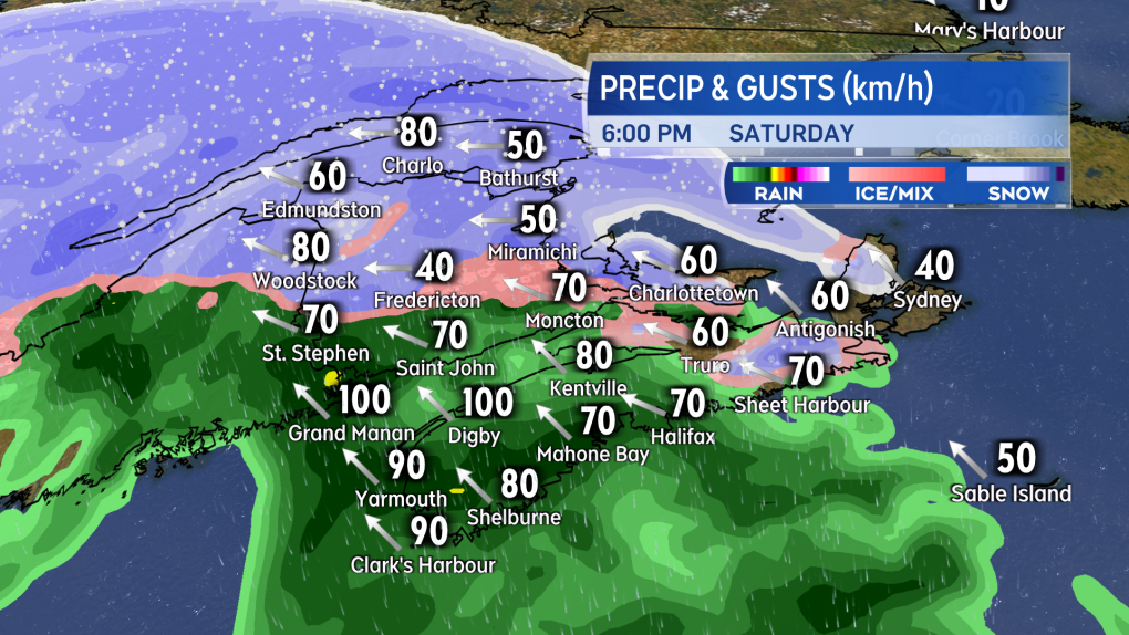
Wind and elevated water levels will be a concern for parts of the province. The strongest gusts will arrive late Saturday afternoon through evening. Peak gusts from the east and southeast could near 90 km/h on parts of the coast. Speaking of the coast, we are near high astronomical tides this weekend. Due to large waves and the high wind, water levels at high tides on Saturday could come up above the usual mark.
Finally, temperatures Sunday morning may fall back below freezing. Be cautious of wet and slushy surfaces turning icy.
A special weather statement advising of the expected conditions has been issued by Environment Canada for the province.
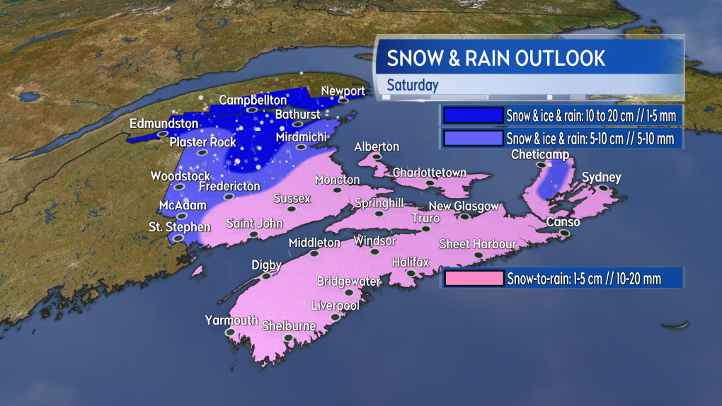 The most snow accumulation is expected in northern areas of New Brunswick on Saturday.
NOVA SCOTIA
Saturday morning begins with increasing cloudiness in the province. Late morning through afternoon will see a brief period of snow turn quickly over to rain across mainland Nova Scotia. Snow turning to rain will be arriving for Cape Breton in the late afternoon and evening. Little more than an initial few centimetres of snow is expected before the turn to rain. Rain amounts could total near 20 mm for parts of the province.
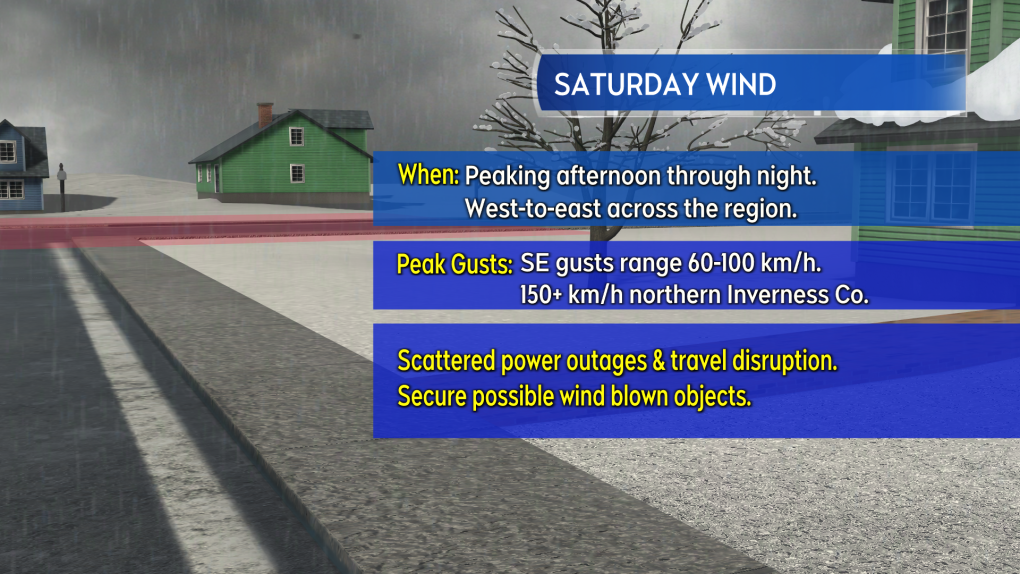
Strong and gusty southeast winds will arrive in the southwest of Nova Scotia by near noon on Saturday. The strong wind will be moving west-to-east across the province Saturday afternoon and evening. Cape Breton should clear that stronger wind by the early morning hours of Sunday.
The southeast gusts could peak as high as 70 to 100 km/h for much of the province. There is a risk of scattered power outages and travel service disruptions. Saturday evening and night could see the area of Inverness County, Cape Breton, from near St. Joseph du Moine to Cheticamp once again reach gusts of 140 to 170 km/h. The even stronger gusts there are a result of the topography of the Cape Breton Highlands. That situation should improve by Sunday morning.
Southeast facing parts of the Atlantic coastline should be cautious of higher than normal water levels during high tides. Large and crashing waves will also be present as the stronger winds move through.
A special weather statement advising of the expected conditions has been issued by Environment Canada. Wind warnings have been issued in the southwest of Nova Scotia.
 The mix of precipitation and strong wind come in a bit later in the day compared to the Wednesday system.
PRINCE EDWARD ISLAND AND MAGDALEN ISLANDS
There shouldn’t be any major weather issues for Prince Edward Island through Saturday morning. Saturday afternoon could see some light snow move through the province. Saturday evening will see snow turn through ice pellets to rain. Snow amounts of 5 cm or less will be followed by 5 to 15 mm of rain.
A strong southeast wind will be present for P.E.I. Saturday evening through near midnight. Peak gusts could reach 90 km/h and possibly near 100 km/h on exposed areas of the coast. The wind will diminish quickly into early Sunday morning. Like the wind on Wednesday, there will be a risk of some power outages and possible travel disruptions, including a period of restriction or closure for the Confederation Bridge.
Similar weather conditions and peak winds are expected for the Magdalen Islands Saturday night, with improvement there by Sunday morning.
Special weather statements advising of the expected inclement weather are in effect for both P.E.I. and the Magdalen Islands.
 Peak winds look close to what went through the region on Wednesday. Similar impacts can be expected, including possible power outages and disruption to travel services.”>
SUMMARY
Very similar weather impacts are expected compared to Wednesday. The latest system does arrive a bit later in the day compared to Wednesday and, in general, the snow and rain amounts look a little lower. Peak wind strength looks about the same as Wednesday and could have similar impacts.
I’ll have updates, timelines, and regional weather conditions on CTV News Atlantic programming.
Shopping Trends
The Shopping Trends team is independent of the journalists at CTV News. We may earn a commission when you use our links to shop. Read about us.


Atlantic Top Stories
-
-
-
 W5 Investigates
W5 Investigates 'I'm in financial ruin': Canadian homeowners sound alarm over contractor accused of fraud
-
-
-
-
-


CTVNews.ca Top Stories
W5 Investigates
W5 Investigates 'I'm in financial ruin': Canadian homeowners sound alarm over contractor accused of fraud
This W5 investigation focuses on mother and daughter homeowners who found themselves in a fight with a general contractor over money they say they're owed, and over work that was never completed on their dream home.
Liberal MPs gather for first time since Trudeau announced his resignation plans
Liberal MPs are meeting in Ottawa today for the first time since Prime Minister Justin Trudeau announced he will step down.
Thousands flee as wildfires burn out of control in and around Los Angeles and homes are destroyed
California firefighters battled wind-whipped wildfires that tore across the Los Angeles area, destroying homes, clogging roadways as tens of thousands fled and straining resources as officials prepared for the situation to worsen early Wednesday.
Trump is open to using 'economic force' to acquire Canada; Trudeau responds
Prime Minister Justin Trudeau said 'there isn't a snowball's chance in hell that Canada would become part of the United States,' on the same day U.S. president-elect Donald Trump declared that he's open to using 'economic force' to acquire Canada.
Thinking of a career change? Here's what employers are hiring for this year
As 2025 gets into full swing, gaps in Canada's job market offer new opportunities to start fresh -- in some sectors, more than others.
A B.C. mom's real-life nightmare and the search to find her trafficked daughter
A Vancouver island mom shares the story of what happened to her teenaged daughter – and a warning for other parents about sex trafficking.
Canadian naval vessel shadowed by Chinese war ship in the East China Sea
CTV National News is on board HMCS Ottawa, embedded with Canadian Navy personnel and currently documenting their work in the East China Sea – a region where China is increasingly flexing its maritime muscle. This is the first of a series of dispatches from the ship.
'What are we talking about?' Experts respond to Trump's 'economic force' comments
Incoming U.S. president Donald Trump's threats to use 'economic force' against Canada and its industries are sparking worry and disbelief.
Is Donald Trump kidding? Americans in Canada react to tariff, annexation threats
While Donald Trump's comments on tariffs and Canada becoming 'the 51st state' have drawn anger and fear among Canadians, reaction from Americans who live, study or work in Canada has been mixed, and is largely influenced by how they voted in the presidential election.
Toronto
-

150 workers terminated after Canada-based company behind listeria outbreak files for creditor protection
Roughly 150 workers at a Canada-based beverage manufacturing and packaging company are demanding answers after recently losing their jobs without warning.
-
Strike averted as Ontario college faculty union, employers enter binding arbitration
The bargaining agent for Ontario's 24 public colleges and the union representing faculty have agreed to enter into binding arbitration, avoiding a strike.
-
Ontario's family doctor shortage will 'get worse' without immediate intervention: experts
As Ontario politicians scramble to come up with plans to address Ontario’s doctor shortage, the situation is likely to “get worse before it gets better,” the president of the Ontario Medical Association says.
Calgary
-

'Oh, it's concerning': Albertans react to Trump's comments on using 'economic force' to acquire Canada
Donald Trump's latest comments on Canada becoming the 51st state caught many Albertans off guard Tuesday, after the U.S. president-elect said he wouldn't use military power but was considering using economic force to make it happen.
-
Calgary city council receives fourth straight pay raise
Calgary city councillors are enjoying another pay bump, marking the fourth consecutive year of salary increases. As of Jan. 1, the mayor and councillors received a 3.07 per cent raise, bringing the total increase since 2022 to 9.5 per cent.
-
Parachute was not deployed in fatal southern Alberta glider crash: TSB
An investigation into a fatal glider crash in southern Alberta last year confirmed the pilot managed to get out of his aircraft, but his parachute failed to open.
Edmonton
-

Alberta business braces for looming U.S. tariffs, embraces potential opportunities because of them
While Alberta's trading future with the United States is uncertain given the imminent threat of punishing tariffs promised by incoming President Donald Trump, business leaders say there is reason for optimism the province could avoid extensive blowback given the importance of energy to Canada's neighbouring global superpower.
-
Oilers shut out Bruins in Boston for fourth win in a row
Adam Henrique scored twice, Stuart Skinner made 26 saves and the Edmonton Oilers won their fourth straight game, beating the Bruins 4-0 on Tuesday in Boston.
-
'It's really exhausting': What 1 councillor says could speed up Edmonton’s construction troubles
City Councillor Andrew Knack is looking for solutions to make the city’s construction in the west end more bearable for drivers.
Montreal
-

Quebec woman charged after allegedly abandoning newborn outside
A 38-year-old woman was charged after allegedly abandoning her newborn shortly after giving birth outside in Trois-Rivières on New Year's Day.
-
Seniors forced to leave Hochelaga-Maisonneuve retirement home early amid closure controversy
Seniors forced to leave Hochelaga-Maisonneuve retirement home early amid closure controversy
-
2 injured after getting hit by potential stolen car in Montreal
Two people are injured after their vehicle was hit by a car that Montreal police suspects could have been stolen.
Ottawa
-

Strike averted as Ontario college faculty union, employers enter binding arbitration
The bargaining agent for Ontario's 24 public colleges and the union representing faculty have agreed to enter into binding arbitration, avoiding a strike.
-
Cold temperatures continue to grip Ottawa with a wind chill of -18 today
The stretch of cold weather gripping Ottawa will continue today and through the rest of the week, which is good news for people hoping to skate on the Rideau Canal Skateway.
-
Homeless man found 'frozen to death' in downtown Ottawa, councillor says
Somerset ward councillor Ariel Troster says she's "devastated" after a man sleeping in the streets of downtown Ottawa was found "frozen to death" on Monday.
London
-

2024 market conditions got some buyers 'off of the fence': LSTAR
According to the London and St. Thomas Realtors Association, the biggest contributing factor was the decrease in interest rates.
-
College strike narrowly avoided in Windsor and London: OPSEU
The college faculty strike has been just barely avoided after six months of negotiations.
-
More snow expected in London today, with accumulation set to taper off by the end of the week
Snowy conditions experienced in the London area over the past 24 hours will persist well into Wednesday.
Barrie
-

Snow day for areas of Simcoe County
Simcoe County has cancelled school buses in the west and south regions.
-
Winter weather travel advisory issued for Simcoe County
Environment Canada has issued a weather advisory for parts of central Ontario.
-
Police warn about ‘aggressive text scam’ circulating locally
The Barrie police fraud unit is warning residents about an “aggressive text messaging scam” it says is circulating locally.
Northern Ontario
-

Fatal crash between pickup, train in northern Ontario
The driver of a pickup truck has died following a collision with a train in northern Ontario on Tuesday morning.
-
Northeastern Ont. police lay 139 impaired driving charges in six weeks
Efforts to reduce impaired driving in northeastern Ontario appear to be working in some communities, but are still high as provincial police release results of their Holiday season sobriety checks.
-
Sault man charged in weekend stabbing
A 26-year-old man from Sault Ste. Marie has been charged with aggravated assault and assault with a weapon following a stabbing in the city over the weekend.
Kitchener
-

New details released in case against admitted doula defrauder in Ontario
A woman, who previously admitted to faking pregnancies and defrauding numerous doulas, has pleaded guilty again to similar crimes, committed while serving her sentence on the original set of charges.
-
Unsafe car pulled off the road in Waterloo, driver charged
The Waterloo Regional Police Service has shared details of an unusual traffic stop in Waterloo.
-
To amalgamate or not? Brant County and Brantford mayors pick sides
The mayors of Brant County and Brantford are at odds over the idea of amalgamation.
Windsor
-

Police seize $20,000 in drugs, arrest employee at downtown magic mushroom shop
Windsor police seized $20,570 in illegal drugs and charged one individual after a raid at a downtown Windsor psilocybin dispensary on Monday afternoon.
-
College strike narrowly avoided in Windsor and London: OPSEU
The college faculty strike has been just barely avoided after six months of negotiations.
-
Help needed after Wings Rehab Centre changes volunteer protocols amid avian flu concerns
In a post online, Wings Rehab indicated that effective this week, volunteers under the age of 18 are no longer permitted to assist at the animal rehabilitation facility, and that all adult volunteers are now required to have a current flu vaccination until further notice.
Winnipeg
-

Patient dies in waiting room at Winnipeg hospital
An investigation is underway after a patient waiting for care died in the waiting room at a Winnipeg hospital Tuesday morning.
-
Manitoba regulator orders hike in auto premiums, calls for action on brain injuries
Manitobans will soon be paying more for basic automobile insurance.
-
'Unacceptable': Removal of beaver dam in Manitoba community sends surge downstream
The removal of a beaver dam in a rural Manitoba community is having some unintended consequences, sending a small flood downstream, catching residents off-guard.
Regina
-

Saskatchewan's teacher/student ratio becomes topic of debate as opposition sounds alarm
As those across the province await the verdict from binding arbitration between the province and the Sask. Teachers Federation (STF) – the Official Opposition is raising alarms over the teacher student ratio.
-
'Accessibility is the key': Breast cancer screening bus rolls into Weyburn
The Saskatchewan Cancer Agency's Breast Screening Bus has made its way to Weyburn, just in time for the beginning of new screening standards in the province.
-
Sask. man who withheld daughter to prevent COVID vaccination appeals conviction
A Saskatchewan father who was found guilty of withholding his daughter in contravention of a custody order is appealing his conviction.
Saskatoon
-

Crown challenges ruling in THC-impaired driving case where child was killed
The Crown has filed an appeal in a high-profile case involving the death of nine-year-old Baeleigh Maurice.
-
Chaos in Ottawa means uncertainty, opportunity for some Sask. industries
One day after the Prime Minister announced his intention to resign, observers are waiting to learn what a prorogued Parliament means for Saskatchewan.
-
These 90-year-old identical twins were born on a Saskatchewan farm, but grew to love the city
Rose Worona and Anne Skwarchuk were born in 1935 on a farm near Hafford. Now, they’re celebrating their 90th birthday together.
Vancouver
-

B.C. bird watcher’s ‘face feeder’ viral videos prompt caution from public health officials
An Abbotsford woman’s bird feeding videos are garnering millions of views online, but while the videos are going viral – public health experts are urging caution as Avian influenza still poses a risk to the region.
-
A B.C. mom's real-life nightmare and the search to find her trafficked daughter
A Vancouver island mom shares the story of what happened to her teenaged daughter – and a warning for other parents about sex trafficking.
-
4 generations on 1 lot: One family's creative response to B.C.’s housing crisis
A single lot in Delta, B.C., that used to be home to a single rancher built in the 80s is the site of four separate homes, housing four generations of the same family.
Vancouver Island
-

A B.C. mom's real-life nightmare and the search to find her trafficked daughter
A Vancouver island mom shares the story of what happened to her teenaged daughter – and a warning for other parents about sex trafficking.
-
'We're a rudderless ship': B.C. industry leaders bracing for Trump's impact
During a news conference Tuesday, U.S. President-elect Donald Trump didn't hold back in his message to Canada.
-
CRA to collect increased capital gains taxes despite proposed hike not being passed into law
The Canada Revenue Agency expects Canadians to adhere to a proposed capital gains tax increase – despite the fact the measure may never be passed into law.
Kelowna
-

1 hospitalized, residents displaced after Kelowna apartment fire
Firefighters knocked down a blaze on the third floor of a low-rise apartment building near downtown Kelowna Monday afternoon.
-
Lost skiers rescued off B.C. mountain
Search and rescue volunteers in B.C.’s Okanagan successfully reunited two skiers with their family Friday evening.
-
Charges laid after child porn investigation that 'spanned several different countries,' Kelowna RCMP say
Police in Kelowna say an international investigation has led to child pornography charges against a 46-year-old man.


