Rainfall warnings issued as remnants of Hurricane Beryl head towards the Maritimes
 A pedestrian shields herself from the rain with an umbrella while walking downtown in Halifax on Monday, October 30, 2017. THE CANADIAN PRESS/Darren Calabrese
A lake's worth of water still in Beryl
While the remnants of what was Hurricane Beryl are a shadow of its former strength when it comes to winds and waves, it still packs a tremendous amount of moisture.
Estimating an average of 40 mm of precipitable water available across a very approximate 1,000,000 square kilometres that the body of the storm covers gives a volume of 40 cubic kilometres worth of water. That is a volume of water on the scale of Bras d’Or Lake in Cape Breton, which has an approximate value of 32 cubic kilometre.
While not all that moisture will be squeezed out of the atmosphere in the form of rain, and what rain does come will be spread over a very large area as the remnants continue to move, it gives a rough idea of the high amount of moisture still contained within it.
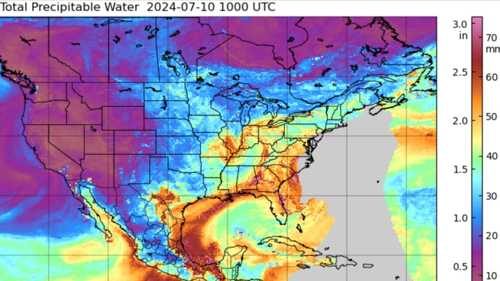 The swirl of yellows, oranges, and reds in the eastern United States showing precipitable water available with the remnants of Beryl. (Source: Cooperative Institute for Meteorological Satellite Studies, University of Wisconsin-Madison)
That increases the risk of heavy rain amounts and downpours. Rainfall warnings are in effect for southern Ontario, southern Quebec and flood watches have been issued in the state of Maine. Those areas are along the path of some of the heaviest rain expected.
Weather alerts have been issued for the Maritimes as well.
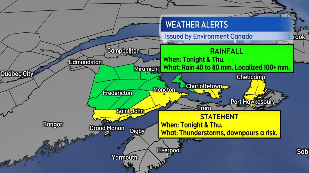
Rainfall warnings and statements for New Brunswick
Rainfall warnings and special weather statements have been issued for much of New Brunswick with the exception of the northernmost areas of the province.
Areas under the rainfall warning are advised that rain arriving late Wednesday evening into Thursday will total 40 to 70 mm with 100 mm or more possible in the heaviest rain. The heaviest rain would be localized and in the form of downpours that could have rain rates as high as 20 to 40 mm per hour increasing the risk of flash flooding.
A special weather statement covers the southern-most area of New Brunswick. It cautions on the possibility of heavy downpours and significant rainfall accumulations. The area has been on the southern edge of the heaviest rain indicated on computer weather model guidance the last few days.
The heaviest rain finished for New Brunswick by Thursday afternoon.
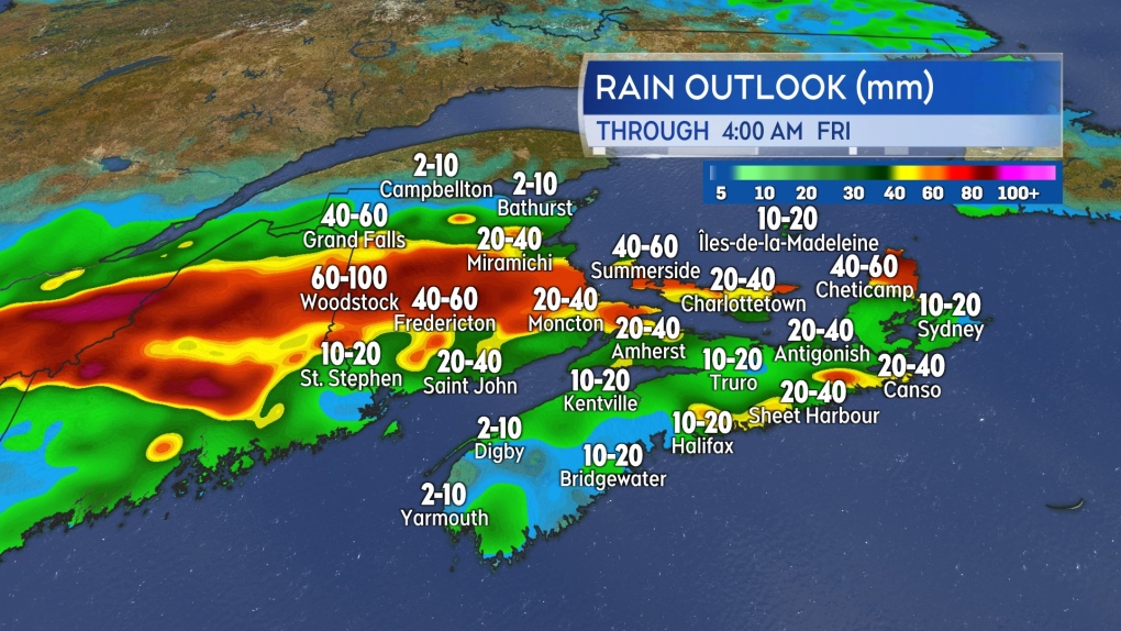 The band of heaviest rain looks lined up to come squarely through New Brunswick, western Prince Edward Island, and possibly parts of Cape Breton Wednesday night into Thursday.
Rainfall warnings and statements for Prince Edward Island
Prince County has been placed under a rainfall warning. Rain beginning Wednesday night and continuing into Thursday evening totalling 40 to 60 mm, except 80 mm or more in the heaviest rain. Like New Brunswick the heaviest rain will be localized due to downpours contained within the system.
The remainder of the province is under a special weather statement. Computer guidance for the heavy rain expected has occasionally included Queens and Kings counties in the higher amounts over the last few days. Communities in those areas should be aware that heavier rain and downpours are still possible.
The heaviest rain should finish for Prince Edward Island by Thursday evening.
 Rainfall warnings and special weather statements issued in the Maritimes ahead of the heavy rain and downpours possible with the remnants of Beryl.
Special weather statements for Nova Scotia
On Wednesday, most of Nova Scotia was indicated as being on the more showery side of Beryl.
Special weather statements are in effect for Inverness and Victoria Counties of Cape Breton. The statements cautioning that heavy rain could impact those areas late Wednesday night into Thursday. Downpours could contribute to some localized flooding.
For the rest of Nova Scotia, it is looking more likely that the inclement weather will be in the form of patchy showers and drizzle. There is a lot of moisture in the area currently due to the humid weather this week. Due to that, some isolated thunderstorms or downpours may still be possible within any occurring showers.
More details on the heat warnings issued for most of the Maritimes can be found here.
Shopping Trends
The Shopping Trends team is independent of the journalists at CTV News. We may earn a commission when you use our links to shop. Read about us.


CTVNews.ca Top Stories

Ottawa has sold its stake in Air Canada: sources
Two senior federal government sources have confirmed to CTV News that the federal government has sold its stake in Air Canada.
Premiers disagree on whether Canada should cut off energy supply to U.S. if Trump moves ahead with tariffs
Some of Canada's premiers appeared to disagree with Ontario Premier Doug Ford on his approach to retaliatory measures, less than a day after he threatened to cut off the province's energy supply to the U.S. if president-elect Donald Trump follows through on his threat of punishing tariffs.
'I recognize these footsteps': How Trump and 'coyote' smuggling changed life at the border
Bent signs bolted to the rail threaten fines and imprisonment should violators cross the boundary into the United States, a warning many people are choosing to ignore simply by walking around the barrier.
She took a DNA test for fun. Police used it to charge her grandmother with murder in a cold case
According to court documents, detectives reopened the cold case in 2017 and then worked with a forensics company to extract DNA from Baby Garnet's partial femur, before sending the results to Identifinders International.
McDonald's employee who called 911 in CEO's shooting is eligible for reward, but it will take time
More than 400 tips were called into the New York Police Department's Crime Stoppers tip line during the five-day search for a masked gunman who ambushed and fatally shot UnitedHealthcare CEO Brian Thompson last week.
Man who set fires inside Calgary's municipal building lost testicle during arrest: ASIRT
Two Calgary police officers have been cleared of any wrongdoing in an incident that saw a suspect lose a testicle after being shot with an anti-riot weapon.
Country star Morgan Wallen sentenced in chair-throwing case
Country music star Morgan Wallen on Thursday pleaded guilty to two misdemeanour counts of reckless endangerment for throwing a chair from the rooftop of a six-storey bar in Nashville and nearly hitting two police officers with it.
Danielle Smith announces new team to patrol Alberta-U.S. border
Premier Danielle Smith says her government will create a team of specially-trained sheriffs tasked with patrolling the Alberta-U.S. border.
Ho ho, oh no: Man sought by police goes down chimney and gets stuck
A Massachusetts man trying to escape from police shimmied down the chimney. And got stuck.
Toronto
-

'Enough is enough': Doug Ford says Ontario could hand encampment drug users $10,000 fines, prison
Ontario Premier Doug Ford says his government is introducing a suite of measures to help municipalities “address and dismantle” homeless encampments around the province, including steep fines for people who use drugs.
-
Video shows suspects armed with sledgehammer break into spa in Markham
Three teenagers and a 19-year-old man have been arrested and three more are at large in connection with a series of spa robberies in Markham and Toronto, one of which was captured on security camera.
-
Dog found after vehicle stolen in Toronto
A dog that was inside a vehicle when it was stolen in Toronto on Wednesday has been found, police say.
Calgary
-

Calgary police to hold news conference following young woman's death
Calgary police will hold a news conference Thursday to speak about the death of a young woman found badly injured on Calgary's Nose Creek Pathway on Monday.
-
Danielle Smith approval rating holds steady at 45%: poll
A new poll from the non-profit Angus Reid Institute finds that Alberta Danielle Smith’s approval rating once again remains relatively unchanged.
-
Man who set fires inside Calgary's municipal building lost testicle during arrest: ASIRT
Two Calgary police officers have been cleared of any wrongdoing in an incident that saw a suspect lose a testicle after being shot with an anti-riot weapon.
Edmonton
-
 BREAKING
BREAKING Travis Vader, killer of Lyle and Marie McCann, denied day parole
The man who killed an Alberta couple in 2010 has been denied day parole.
-
Edmonton police chief to assume leadership roles in Alberta public service, executive council
Dale McFee will start a job in the high level of Alberta's government three days after his last day as the chief of Edmonton Police Service in February.
-
Boyle Street health hub scrapped in Old Strathcona
After more than two years of preparation and pushback, plans for a new health hub in Old Strathcona have been scrapped.
Montreal
-

Montreal homicide rate dropped by more than 20 per cent in 2023: Statistics Canada
Newly released figures from Statistics Canada shows that the rate of homicides in the Montreal area dropped significantly in 2023 compared to the previous year.
-
Quebec to pay 30 times more for power out of N.L. plant after decades-long dispute
Quebec and Newfoundland announced today a new arrangement that will see Quebec pay 30 times more for power from the Churchill Falls hydroelectricity plant in Labrador.
-
Montreal suburb declares 'end of deer saga' after killing 105 animals in urban park
A Montreal suburb is declaring the 'end of the deer saga' today after completing its plan to cull a growing herd of white-tailed deer in one of its parks.
Ottawa
-

Bus parked at OC Transpo depot destroyed by fire
Ottawa firefighters extinguished a bus that was fully engulfed in flames while parked at an OC Transpo depot on Thursday afternoon.
-
Two additional arrests made in connection with Val-des-Monts death investigation
Police have arrested two additional people in connection with an investigation into a woman's death north of Gatineau earlier this month.
-
Crews begin removing cargo from ship stuck in St. Lawrence River in eastern Ontario
Crews have started work on a new attempt to refloat a cargo ship that ran aground in the St. Lawrence River nearly three weeks ago.
London
-

'Music is good for the soul': A holiday concert warms spirits inside the Verspeeten Family Cancer Centre
A holiday concert dubbed ‘Clinic Notes’ warmed hearts inside LHSC’s Verspeeten Family Cancer Centre today. The performance is put on by a group of clinicians, talented in medicine and music.
-
Blizzard warning shuts down large parts of midwestern Ontario
It was a day to stay home, if you could, across much of midwestern Ontario due to weather.
-
40 to 80 cm of snow in some areas: Blizzard and snow squall warnings up across the region
Blizzard and snow squall warnings have rolled across much of southern Ontario – with up to 15 centimeters expected today, and blowing snow reducing visibility on roadways.
Barrie
-

Significant weather event declared in Owen Sound amid blizzard warning
The City of Owen Sound has declared a significant weather event with the region under a blizzard warning on Thursday as lake-effect snow squalls hammer the area.
-
Jack-knifed tractor-trailer caused disruptions on Highway 11 in Gravenhurst
A jack-knifed tractor-trailer caused lane closures along Highway 11 near Bethune Drive South in Gravenhurst.
-
Teen arrested in connection to threat made toward high school: OPP
Provincial police arrested a 17-year-old from Bolton accused of making a threat toward a local high school.
Northern Ontario
-
 BREAKING
BREAKING Northern Ont. bank employee taken to hospital with serious injuries after shooting
An employee at Northern Credit Union in Wawa, Ont., was taken to hospital with serious injuries after a shooter entered the branch and opened fire Thursday morning, the financial institution said in a statement.
-
Stabbing in wooded area of Sudbury results in attempted murder charge
Sudbury police have charged a man, 28, with attempted murder after a stabbing in wooded area off Leslie Street on Wednesday night.
-
Ottawa has sold its stake in Air Canada: sources
Two senior federal government sources have confirmed to CTV News that the federal government has sold its stake in Air Canada.
Kitchener
-
'Enough is enough': Doug Ford says Ontario could hand encampment drug users $10,000 fines, prison
Ontario Premier Doug Ford says his government is introducing a suite of measures to help municipalities “address and dismantle” homeless encampments around the province, including steep fines for people who use drugs.
-
Marathon budget meeting ends without setting Waterloo Region budget
Waterloo Region Council was expected to set the 2025 budget on Wednesday, but after a marathon meeting, councillors left the horseshoe without making a final decision.
-
Settlement reached in complaint over Canada Post layoffs as strike hits four weeks
The union representing Canada Post workers says an unfair labour practice complaint over the company's layoffs has been resolved.
Windsor
-

Shots fired in South Windsor, one injured
An investigation is underway after the Windsor Police Service said multiple shots were fired at a group of people in South Windsor.
-
One injured in Windsor kitchen fire
One person has been injured following a kitchen fire in Windsor.
-
Winnipeg
-

'Concerning:' Manitoba homicides spiked in 2024
Manitoba RCMP has seen a spike in homicides in 2024.
-
Manitoba premier eyes list of possible retaliatory measures for U.S. tariffs
Manitoba Premier Wab Kinew says his government is preparing a list of potential retaliatory measures if the United States government imposes new tariffs on Canadian goods.
-
New hammer rule to be tested at next Grand Slam of Curling event
As far as curling experiments go, a new rule that will be used at the next Grand Slam competition looks like a doozy.
Regina
-

Sask. premier says collaboration needed to tackle border security and avoid Trump tariffs
Saskatchewan Premier Scott Moe says an “all hands-on-deck approach” is needed to address border security concerns to avoid U.S. President-elect Donald Trump's tariff threat on products from Canada and Mexico.
-
Three charged after Regina police officer assaulted during break and enter investigation
Three people are facing a lengthy list of charges after a break and enter investigation led to a Regina police officer being assaulted and injured Tuesday night.
-
Regina General Hospital parkade set to open, will provide 686 more parking spots
The grand opening of a new parkade at Regina's General Hospital was celebrated on Thursday. Staff and visitors to the medical centre will be able to use the new facility on Monday.
Saskatoon
-

Nearly 1,500 people in Saskatoon are homeless, according to the latest count
Nearly 1,500 people in Saskatoon are homeless, according to the latest point-in-time (PiT) Count conducted by the city and outside partners.
-
Prince Albert police release photo of suspect in family/grandparent scam
The Prince Albert Police Service (PAPS) is releasing a photo of a person of interest in connection with a family/grandparent emergency scam following multiple reports.
-
Sask. premier says collaboration needed to tackle border security and avoid Trump tariffs
Saskatchewan Premier Scott Moe says an “all hands-on-deck approach” is needed to address border security concerns to avoid U.S. President-elect Donald Trump's tariff threat on products from Canada and Mexico.
Vancouver
-

Crews search for missing skier at B.C. resort
Police and rescue crews are searching for a man who was last seen boarding a ski lift at B.C.'s Sun Peaks Resort Tuesday.
-
Suspect charged in alleged assault at B.C. golf course
Two months after a golfer allegedly attacked fellow players with a club at a B.C. golf course, a suspect has been charged.
-
Man charged after victim pinned to tree with vehicle in Victoria
A 34-year-old man is facing multiple criminal charges after allegedly striking a man with his vehicle and pinning him against a tree in Victoria, causing serious injuries.
Vancouver Island
-

Man charged after victim pinned to tree with vehicle in Victoria
A 34-year-old man is facing multiple criminal charges after allegedly striking a man with his vehicle and pinning him against a tree in Victoria, causing serious injuries.
-
Police say 42 vehicles vandalized in 'campaign of destruction' in Nanaimo, B.C.
Mounties are investigating after more than 40 vehicles were vandalized in what police described as a "campaign of destruction" across Nanaimo, B.C.
-
Crews search for missing skier at B.C. resort
Police and rescue crews are searching for a man who was last seen boarding a ski lift at B.C.'s Sun Peaks Resort Tuesday.
Kelowna
-

Study of 2023 Okanagan wildfires recommends limiting development in high-risk areas
A study into the devastating wildfires that struck British Columbia's Okanagan region in 2023 has recommended that government and industry limit development in high-fire-risk areas.
-
Kelowna, B.C., to host the Memorial Cup in the spring of 2026
The Western Hockey League's Kelowna Rockets will host the Memorial Cup in the spring of 2026, the Canadian Hockey League said Wednesday.
-
545 vehicles impounded in 332 days: BC Highway Patrol pleads for drivers to slow down
Mounties with the BC Highway Patrol in Kelowna say they've impounded more than 545 vehicles for excessive speed and aggressive driving so far this year. That works out to more than 1.6 per day.


