Records to watch as temperatures soar in the Maritimes Wednesday
Records fall
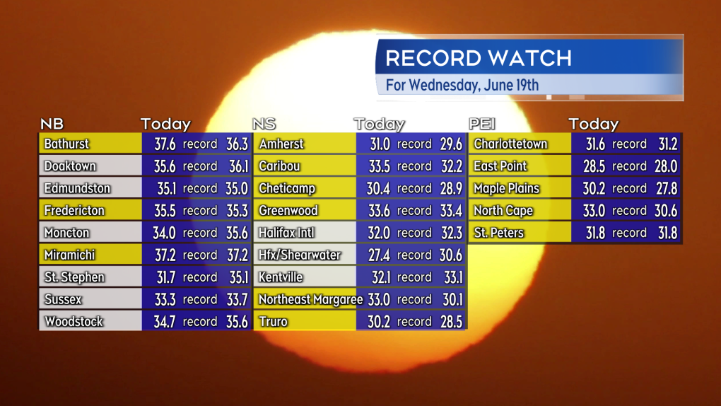
As we moved into the late afternoon, high temperature records for a June 19 fell across all three Maritime provinces.
Many other weather observation sites in the region came within a degree or less of their standing record highs.
As of 5 p.m. ADT Bathurst, N.B., has had the hottest temperature in the country as recorded at Environment Canada-monitored weather stations. That high temperature recorded as 37.6 degrees Celsius.
 New daily high temperature records set in the Maritimes. Unofficial at this time but some of the sites that set new records are shown here highlighted in yellow. (Source: CTV Atlantic)
Peak heat and humidity
The Maritimes is now into the peak of the spell of hot and humid weather. Similar conditions are expected on Thursday. Heat warnings remain in effect for all three Maritime provinces as not only will the days be very hot, but the nights will be very warm, offering little relief.
A cold front moves across the Maritimes late Thursday into early Friday. Less humid air will filter into the Maritimes on Friday. Both temperature and humidity are forecast to fall from the levels of Wednesday and Thursday. Temperature and humidity will both fall a bit more for the start of the weekend.
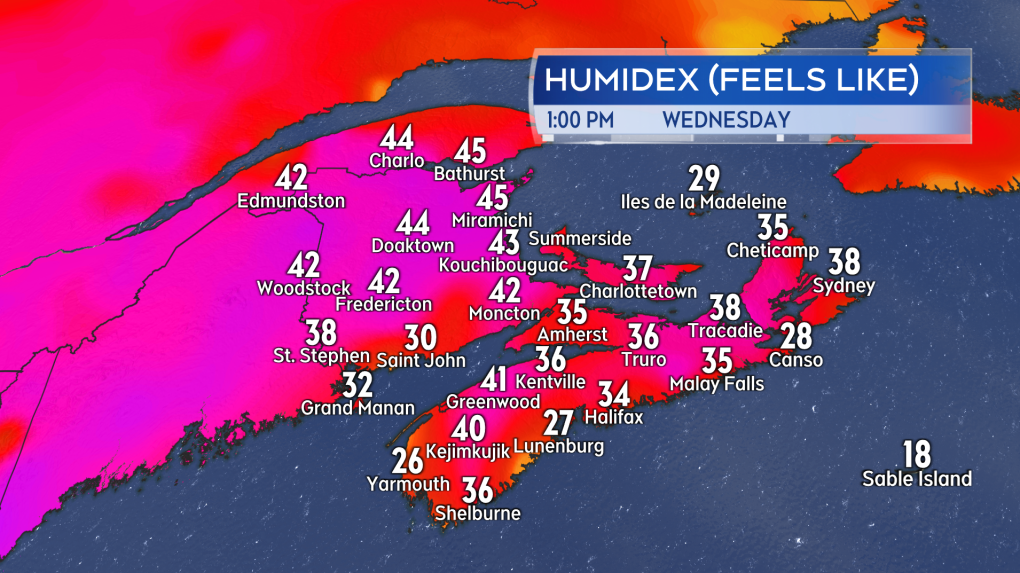
 Afternoon humidex values in the Maritimes, or what it feels like, taking into account temperature and humidity, well into the 30s and in cases the 40s.
Risk of thunderstorms
Heat and humidity can be fuel for thunderstorms. There is a low chance of afternoon and evening thunderstorms in New Brunswick for Wednesday afternoon and evening. Any thunderstorms that do develop will be isolated and so for any given community it is about a 20-30 per cent chance.
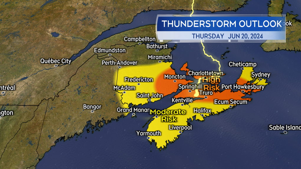
There is a higher risk of scattered thunderstorms in the Maritimes Thursday.
The thunderstorm development on Thursday would be triggered by the cold front moving north to south across the Maritimes. The highest risk for Thursday afternoon and early evening will be in southern New Brunswick, Prince Edward Island, and eastern Nova Scotia. There will also be a Thursday evening and night risk for thunderstorms in western Nova Scotia.
Due to the heat and humidity that will have built up, it is possible some of the thunderstorms could be strong or severe. Hazards would include lightning, strong localized wind gusts, and downpours.
 There will be a higher chance of thunderstorms in the Maritimes Thursday along with a higher risk that some of them could become severe.
Tropical Storm Alberto
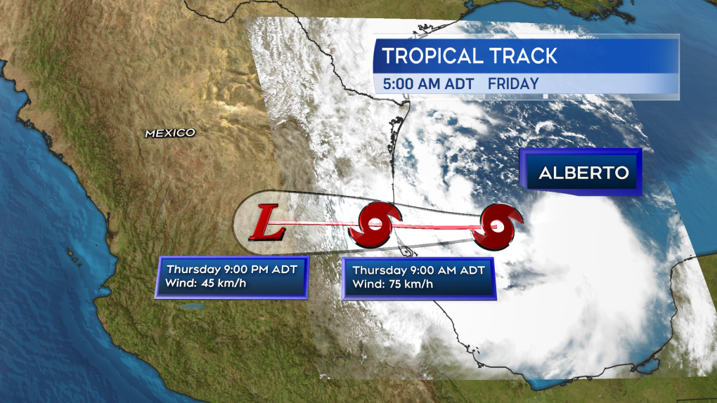
Tropical Storm Alberto developed Wednesday morning in the Gulf of Mexico – the first named storm of the 2024 Atlantic hurricane season. The National Hurricane Center is issuing advisories and forecasts for the storm. The storm is forecast to move onshore near the border of the provinces of Tamaulipas and Veracruz, Mexico, early Thursday morning.
The storm could bring areas of rain, as much as 120 to 250 mm, to parts of northeastern Mexico and southern Texas. The rain will bring a risk of flash flooding and a risk of mudslides where it comes down in more mountainous terrain.
More pictures captured during the Maritimes' heat wave can be seen here.
 The forecast cone for Tropical Storm Alberto in the Gulf of Mexico per the National Hurricane Center.
CTVNews.ca Top Stories

Aviation experts say Russia's air defence fire likely caused Azerbaijan plane crash as nation mourns
Aviation experts said Thursday that Russian air defence fire was likely responsible for the Azerbaijani plane crash the day before that killed 38 people and left all 29 survivors injured.
Police identify victim of Christmas Day homicide in Hintonburg, charge suspect
The Ottawa Police Service says the victim who had been killed on Christmas Day in Hintonburg has been identified.
Teen actor Hudson Meek, who appeared in 'Baby Driver,' dies after falling from moving vehicle
Hudson Meek, the 16-year-old actor who appeared in 'Baby Driver,' died last week after falling from a moving vehicle in Vestavia Hills, Alabama, according to CNN affiliate WVTM.
Boxing Day in Canada: Small retailers fear big shopping day won't make up for tough year
It’s one of the busiest shopping days of the year: Boxing Day sees thousands of people head to malls and big box stores to find great deals. But it's not so simple for smaller shops.
Raised in Sask. after his family fled Hungary, this man spent decades spying on communists for the RCMP
As a Communist Party member in Calgary in the early 1940s, Frank Hadesbeck performed clerical work at the party office, printed leaflets and sold books.
Sinkhole prompts lane closures on Interstate 80 in New Jersey
A sinkhole that opened up Thursday along Interstate 80 in northern New Jersey forced authorities to close the heavily travelled highway's eastbound lanes.
Cat food that caused bird-flu death of Oregon pet was distributed in B.C.: officials
Pet food contaminated with bird flu – which killed a house cat in Oregon – was distributed and sold in British Columbia, according to officials south of the border.
Police in New Brunswick investigating Christmas Eve sudden death
An unconscious individual was found in the 600-block area of Lancaster Avenue early Christmas Eve morning, and was later pronounced dead at a hospital.
Pizza deliverer in Florida charged with stabbing pregnant woman at motel after tip dispute
A pizza deliverer in central Florida has been charged with pushing her way into a motel room with an accomplice and stabbing a pregnant woman after a dispute over a tip, authorities said.


