Risk and timing of thunderstorms in the Maritimes on Thursday
 An Ontario thunderstorm can be seen in this undated file photo. (Courtesy: Ernie Szelepcsenyi)
Thursday thunderstorms
Showers along with a risk of thunderstorms will return to the Maritimes on Thursday as a cold front approaches from the west.
The front is moving through southern Ontario and southern Quebec on Wednesday, triggering thunderstorms in those provinces. Some of the thunderstorms became severe, packing wind gusts up to 90 km/h and downpours producing rain rates of up to 50 mm/hr.
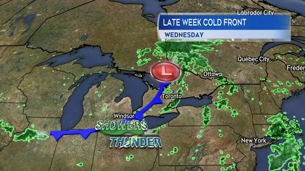 A cold front crossing Ontario and Quebec Wednesday is triggering thunderstorms for those provinces.
While the Maritimes won’t be as primed for severe thunderstorms as Ontario and Quebec Thursday, there is still reason to have some weather awareness on that day. If we do end up with some severe thunderstorms in the region Thursday, they could produce similar hazards along with lightning, which is dangerous any time.
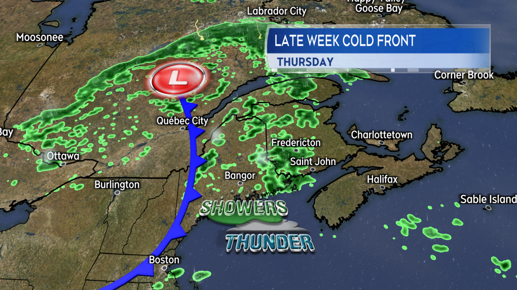 The same cold front approaches the Maritimes late Thursday into Friday. Showers with a risk of thunderstorms ahead of it.
Thunderstorm timing
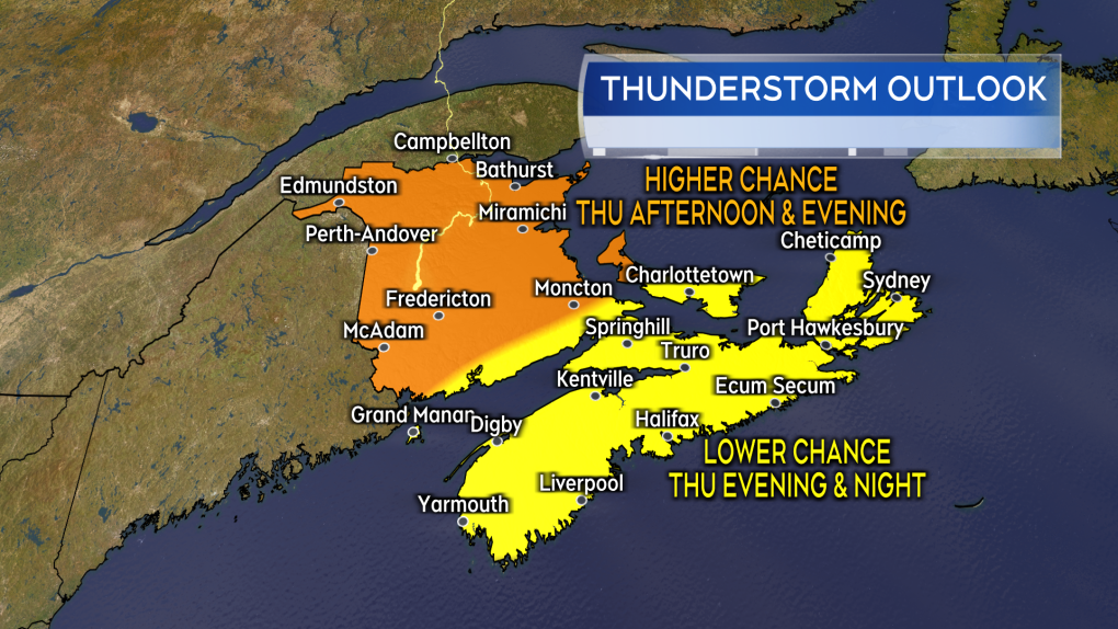
Showers are expected to develop across New Brunswick late Thursday morning through afternoon. The showers will be moving across Nova Scotia and Prince Edward Island Thursday evening and night. A risk of thunderstorms will accompany the showers.
The highest chance of thunderstorms will be in New Brunswick and Prince County, P.E.I., Thursday afternoon and evening. There will be a lower chance of thunderstorms for the remainder of P.E.I. and Nova Scotia Thursday evening and night.
As above, if any severe thunderstorms develop, the most likely hazards would be strong wind gusts, downpours, and lightning.
 The risk and timing of thunderstorms in the Maritimes on Thursday.
What follows for the weekend
There will be isolated showers for P.E.I. and northern/eastern areas of Nova Scotia on Friday.
Humidity falls Friday into Saturday. The weekend forecast is mostly sunny at this time.
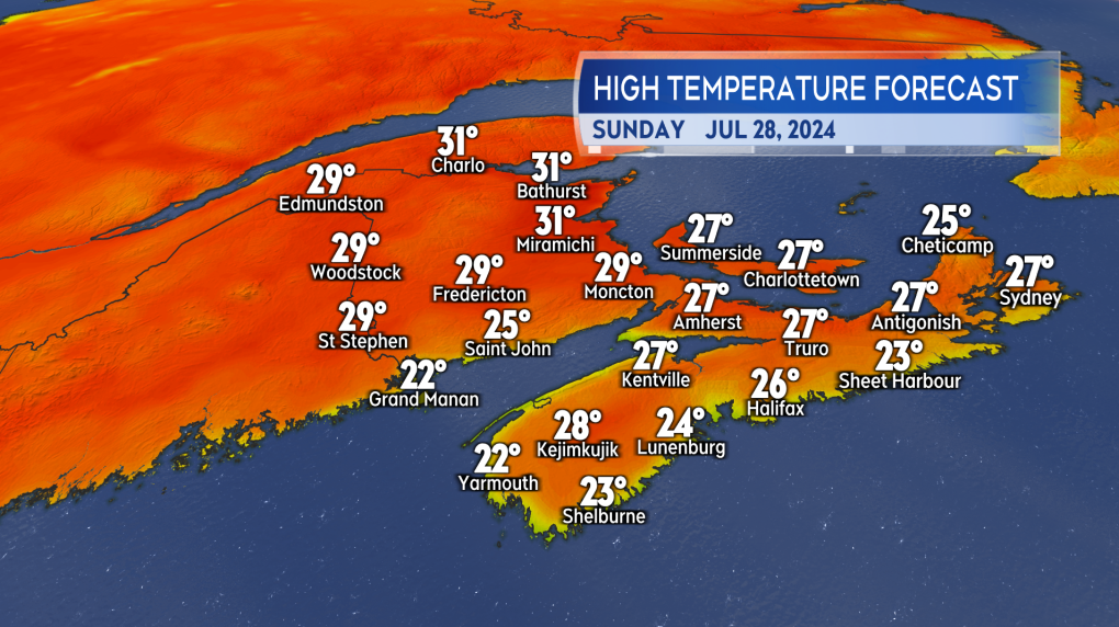
We will be back to some summer scorchers by Sunday and early next week. It looks like daytime highs will be back into the high 20s and low 30s. Temperatures will be in the low-to-mid 20s for coastal areas where wind is directly onshore, off ocean waters. That looks to be mostly for parts of the Atlantic coastline of Nova Scotia and the Bay of Fundy coastline of New Brunswick.
 Lots of sun in the weekend forecast. Hotter summer weather back in place by Sunday.
Shopping Trends
The Shopping Trends team is independent of the journalists at CTV News. We may earn a commission when you use our links to shop. Read about us.


CTVNews.ca Top Stories

Bird flu, measles top 2025 concerns for Canada's chief public health officer
As we enter 2025, Dr. Theresa Tam has her eye on H5N1 bird flu, an emerging virus that had its first human case in Canada this year.
DEVELOPING
DEVELOPING Body found in wheel well of plane at Maui airport
A person was found dead in the wheel well of a United Airlines flight to Maui on Tuesday.
Raised in Sask. after his family fled Hungary, this man spent decades spying on communists for the RCMP
As a Communist Party member in Calgary in the early 1940s, Frank Hadesbeck performed clerical work at the party office, printed leaflets and sold books.
Police identify victim of Christmas Day homicide in Hintonburg, charge suspect
The Ottawa Police Service says the victim who has been killed on Christmas Day in Hintonburg has been identified.
Christmas shooting at Phoenix airport leaves 3 people wounded
Police are investigating a Christmas shooting at Sky Harbor Airport in Phoenix that left three people injured by gunfire.
Ship remains stalled on St-Lawrence River north of Montreal
A ship that lost power on the St. Lawrence River on Christmas Eve, remains stationary north of Montreal.
Your kid is spending too much time on their phone. Here's what to do about it
Wondering what your teen is up to when you're not around? They are likely on YouTube, TikTok, Instagram or Snapchat, according to a new report.
Bird flu kills more than half the big cats at a Washington sanctuary
Bird flu has been on the rise in Washington state and one sanctuary was hit hard: 20 big cats – more than half of the facility’s population – died over the course of weeks.
6,000 inmates stage Christmas Day escape from high-security Mozambique prison
At least 6,000 inmates escaped from a high-security prison in Mozambique's capital on Christmas Day after a rebellion, the country's police chief said, as widespread post-election riots and violence continue to engulf the country.
Toronto
-

Boxing Day bargain hunters hit GTA stores in search of deals
Deal hunters are hitting stores around the GTA today to try take advantage of Boxing Day bargains and a tax holiday that offers further discounts.
-
Man wanted for 2 unprovoked incidents in downtown Toronto on Christmas Eve
Toronto police are searching for a suspect who allegedly choked a female in downtown Toronto then threatened an employee at a business with a hammer.
-
1 person seriously injured in Scarborough stabbing
One person was taken to the hospital with serious, but non-life-threatening injuries following a stabbing on Dec. 25 in Scarborough, say paramedics.
Calgary
-

Naheed Nenshi finding his feet leading an Alberta NDP still under construction
Nenshi finding his feet leading an Alberta NDP still under construction
-
Bird flu, measles top 2025 concerns for Canada's chief public health officer
As we enter 2025, Dr. Theresa Tam has her eye on H5N1 bird flu, an emerging virus that had its first human case in Canada this year.
-
Solar burgers: How agrivoltaics is marrying food production with green energy
Jason Bradley spent 20 years of his career as ranch manager at a 50,000-acre grazing operation in west-central Alberta, so he understands why people react with skepticism to the idea of raising a herd of cattle on a working solar farm.
Edmonton
-

Alberta premier hopes for health reform payoff in 2025, regrets deferring tax cut
"It may have been better for Albertans if we'd implemented and then found a way to be able to pay for it."
-
Naheed Nenshi finding his feet leading an Alberta NDP still under construction
Nenshi finding his feet leading an Alberta NDP still under construction
-
Donald Trump says he urged Wayne Gretzky to run for prime minister in Christmas visit
U.S. president-elect Donald Trump says he told Canadian hockey legend Wayne Gretzky he should run for prime minister during a Christmas visit but adds that the athlete declined interest in politics.
Montreal
-
 WEATHER
WEATHER Smog warning in effect in Montreal, Laval
Residents of Montreal, Laval and other regions are advised that a smog warning is in effect.
-
Teen cancer patient pays forward Make-A-Wish donation to local fire department
A 16-year-old cancer patient from Hemmingford, Que. decided to donate his Make-A-Wish Foundation gift to the local fire department rather than use it himself.
-
Ship remains stalled on St-Lawrence River north of Montreal
A ship that lost power on the St. Lawrence River on Christmas Eve, remains stationary north of Montreal.
Ottawa
-

Police identify victim of Christmas Day homicide in Hintonburg, charge suspect
The Ottawa Police Service says the victim who has been killed on Christmas Day in Hintonburg has been identified.
-
World Junior Championship to create a buzz in Ottawa this Boxing Day
A Canadian hockey holiday tradition returns to the capital this Boxing Day, as the 2025 World Junior Championship is set to create a buzz in the city.
-
Ottawa G1 driver caught driving uninsured, unaccompanied with out-of-service plate on HWY 417
A G1 driver is facing multiple charges after being stopped on Highway 417 in Ottawa for out-of-service licence plate Wednesday, according to the Ontario Provincial Police (OPP).
London
-

Palace Theatre boarded up over the holidays due to recent damage
A break in, theft, and continued property damage has led to the boarding up of the Palace Theatre over the Christmas holidays.
-
Knights stars ready to help Canada chase gold at World Juniors
Three London Knights are on the roster, including Easton Cowan, who scored a hat-trick in Canada’s first exhibition game.
-
London fire responds to Wellington Road collision, contains fuel leak
London Fire Department was on the scene of a two vehicle collision involving a delivery truck on Tuesday morning.
Barrie
-

Health board reminds of resources for holiday grieving
The Board of Health of Grey Bruce Public Health is reminding those who are experiencing grief, loss, isolation or other challenges during the holiday season that there are helpful resources and supports available.
-
Teen driver faces impaired driving charges after Christmas Eve accident
A 19-year-old was charged with multiple offences after allegedly crashing into a Highway 11 ditch in Orillia on Christmas Eve.
-
Woman charged after driving in oncoming traffic: OPP
A 78-year-old female driver is facing charges after reportedly driving into oncoming traffic in Wasaga Beach on Christmas Eve.
Northern Ontario
-
Bird flu, measles top 2025 concerns for Canada's chief public health officer
As we enter 2025, Dr. Theresa Tam has her eye on H5N1 bird flu, an emerging virus that had its first human case in Canada this year.
-
Indigenous family faced discrimination in North Bay, Ont., when they were kicked off transit bus
Ontario's Human Rights Tribunal has awarded members of an Indigenous family in North Bay $15,000 each after it ruled they were victims of discrimination.
-
Swimmer Summer McIntosh voted The Canadian Press female athlete of the year for 2024
During the month before her 18th birthday, Summer McIntosh became the first Canadian to win three gold medals in a single Olympic Games, winter or summer, with a silver medal thrown in for good measure.
Kitchener
-

Marking the start of Hanukkah in Guelph and Waterloo Region
People across Guelph and Waterloo Region are celebrating the start of Hanukkah.
-
Baden-born player, Guelph Storm forward and former Kitchener Ranger prepare to hit the ice at World Juniors
Waterloo Region and Guelph will be well represented as the International Ice Hockey Federation World Juniors gets underway.
-
Boxing Day bargain hunters hit GTA stores in search of deals
Deal hunters are hitting stores around the GTA today to try take advantage of Boxing Day bargains and a tax holiday that offers further discounts.
Windsor
-

Mother-daughter duo pursuing university dreams at the same time
For one University of Windsor student, what is typically a chance to gain independence from her parents has become a chance to spend more time with her biggest cheerleader — her mom.
-
VIDEO
VIDEO From a repaired stuffed animal to an ATV, shoppers reveal the best gift they have ever received
We asked people of all ages getting in some last-minute Christmas Eve shopping inside Windsor’s Devonshire Mall to talk about the best present they've ever received — and their answers might just warm your heart this holiday season.
-
'We may have to look at other sensible locations': Where will Windsor’s new H4 be located?
The search for a site to house Windsor’s new Homelessness and Housing Help Hub (H4) is back underway after the city scrapped plans at 700 Wellington Avenue on Monday.
Winnipeg
-

'They gambled with trees': Cutting down trees resumes in Lemay Forest
The next chapter of the Lemay Forest saga has unfolded as the sounds of trees coming down could be heard Monday.
-
One person dead, another injured following Monday night house fire
One person has died and another is in unstable condition following a house fire Monday evening.
-
Winnipeg police investigating string of packages being stolen
The Winnipeg Police Service is investigating a string of package thefts in the Transcona area.
Regina
-

Pedestrian collision sends man to hospital with life-threatening injuries
One man has been sent to hospital with life-threatening injuries after he was struck by a vehicle in the early hours of Wednesday in Regina.
-
Raised in Sask. after his family fled Hungary, this man spent decades spying on communists for the RCMP
As a Communist Party member in Calgary in the early 1940s, Frank Hadesbeck performed clerical work at the party office, printed leaflets and sold books.
-
Here's what's open and what's closed in Regina this holiday season
Here's what residents can expect in terms of city services as Regina slides right into the Christmas holidays.
Saskatoon
-
Raised in Sask. after his family fled Hungary, this man spent decades spying on communists for the RCMP
As a Communist Party member in Calgary in the early 1940s, Frank Hadesbeck performed clerical work at the party office, printed leaflets and sold books.
-
IN PICTURES: CTV Saskatoon viewers send us their holiday photos
A living gallery of viewer-submitted photos from the holiday season. Share your pictures with us at SaskatoonNews@bellmedia.ca
-
Sask. highway closed following serious collision
The Saskatchewan RCMP are investigating a serious collision on Highway 7, approximately 15 kilometres west of Rosetown.
Vancouver
-

Multiple sailing waits for BC Ferries after further cancellations
BC Ferries cancelled multiple early morning sailings between the Lower Mainland and Vancouver Island Thursday morning, as weather warnings due to wind and heavy rain remain in effect.
-
Weather warnings in effect for parts of B.C. on Boxing Day
Wet and windy weather is expected to persist for B.C.'s South Coast Thursday, according to Environment Canada – which says conditions are expected to improve before Boxing Day ends.
-
Bird flu, measles top 2025 concerns for Canada's chief public health officer
As we enter 2025, Dr. Theresa Tam has her eye on H5N1 bird flu, an emerging virus that had its first human case in Canada this year.
Vancouver Island
-
Multiple sailing waits for BC Ferries after further cancellations
BC Ferries cancelled multiple early morning sailings between the Lower Mainland and Vancouver Island Thursday morning, as weather warnings due to wind and heavy rain remain in effect.
-
BC Ferries cancels many Christmas Day sailings, says others 'at risk'
The stormy weather in the forecast for B.C.'s South Coast is already disrupting many Christmas Day travel plans.
-
Janitors at Vancouver airport ratify deal with employer, end strike
The janitors who clean the Vancouver International Airport have ratified a new collective agreement with their employer, ending their strike on Christmas Eve.
Kelowna
-

Forfeited Hells Angels clubhouse in Kelowna, B.C., sold to the city
A former Hells Angels clubhouse that was seized by the British Columbia government in 2023 after years of fighting in court has been sold to the City of Kelowna.
-
Death of woman found in Kelowna's Waterfront Park in June deemed 'non-criminal in nature': RCMP
Police in Kelowna say a death they began investigating back in June has now been confirmed as "non-criminal in nature."
-
B.C. man sentenced for 'execution-style' murder of bystander in drug trade conflict
A B.C. man convicted of the "intentional and ruthless killing of a bystander" while acting as an enforcer in the drug trade has been sentenced for a second time in the slaying.


