Snowfall, winter storm warnings issued for Nova Scotia
A developing nor'easter moving northward off the coast of North Carolina will pass south and east of Nova Scotia late Monday into Tuesday.
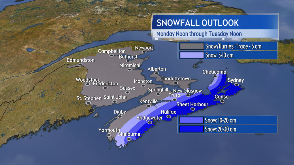
The easterly track is favourable for keeping cold air in place, while at the same time wrapping in moisture off the Atlantic. The combination of the cold and moisture will result in snow. The highest potential for heavier snow, amounts exceeding 15 cm, will be near the Atlantic coastline of Nova Scotia and across a broader area in the east of the province.
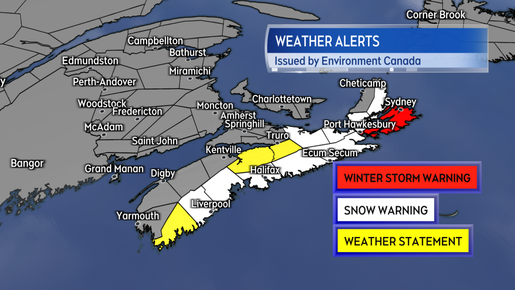
 Weather warnings related to heavy snow are in effect for a large area of Nova Scotia.
As of Monday morning, snowfall warnings are in effect for the South Shore through Halifax County, up the Eastern Shore, Pictou/Antigonish Counties, and into Cape Breton. The warnings call for snow totals up to 25 cm. Along with snowy road conditions, Environment Canada cautions, "as temperatures fall (Monday night), drier snow and blowing snow over exposed areas can be expected."
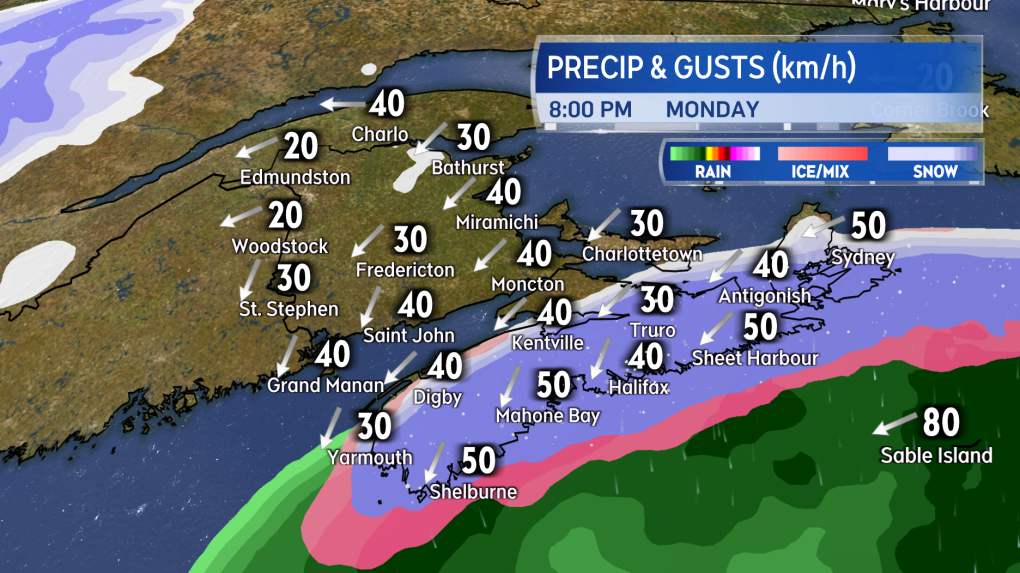
A winter storm warning is in place for Richmond and Cape Breton Counties. Heavier snow and higher wind gusts could create even more difficult weather conditions in this part of the province Monday evening into Tuesday morning. The northerly wind may reach peak gusts of 60 to 80 km/h around the coast and at higher terrain creating more extensive blowing snow.
Special weather statements are in place for Shelburne, Hants, and southern Colchester Counties. Snow amounts in these areas could reach up to 15 cm. The precipitation in Shelburne County is likely to start as a mix of rain and ice pellets before turning to snow by late afternoon.
 The heaviest snow is expected around the South Shore and then broadening to impact a larger area of the east of the province.
The snow will start as early as near noon Monday in Yarmouth and Shelburne Counties. The snow may initially be mixed with some ice pellets and rain. By 5 p.m. Monday, snow will be falling up and down the Atlantic coastline of mainland Nova Scotia from Yarmouth to Canso. By 9 p.m., the snow will have developed across Cape Breton. From there, the snow will clear mainland Nova Scotia early Tuesday morning but may linger in Cape Breton until near noon on Tuesday. Scattered areas of lighter snow and flurries are possible in other parts of the Maritimes as the system passes with much lower snow accumulations expected.
A north/northeast wind will accompany the falling snow. The wind will increase to become sustained 20 to 30 km/h with gusts reaching 40 to 60 km/h. While below warning criteria, the wind is enough to get the snow blowing around -- further reducing visibility. This is especially true as temperatures get colder Monday evening and night.
 Heavy snow and blowing snow will make travel on roads difficult and hazardous for a large area of Nova Scotia Monday evening into Tuesday morning.
Continue to check in frequently on your forecast, particularly if you are in Nova Scotia or are planning to travel in that province Monday afternoon into Tuesday morning. I'll have continued updates on CTV Atlantic News programming Noon, 5, 6, and 11:30 p.m. as well as to our website.
CTVNews.ca Top Stories

Richard Perry, record producer behind 'You're So Vain' and other hits, dies at 82
Richard Perry, a hitmaking record producer with a flair for both standards and contemporary sounds whose many successes included Carly Simon’s 'You’re So Vain,' Rod Stewart’s 'The Great American Songbook' series and a Ringo Starr album featuring all four Beatles, died Tuesday. He was 82.
Hong Kong police issue arrest warrants and bounties for six activists including two Canadians
Hong Kong police on Tuesday announced a fresh round of arrest warrants for six activists based overseas, with bounties set at $1 million Hong Kong dollars for information leading to their arrests.
Read Trudeau's Christmas message
Prime Minister Justin Trudeau issued his Christmas message on Tuesday. Here is his message in full.
Stunning photos show lava erupting from Hawaii's Kilauea volcano
One of the world's most active volcanoes spewed lava into the air for a second straight day on Tuesday.
Indigenous family faced discrimination in North Bay, Ont., when they were kicked off transit bus
Ontario's Human Rights Tribunal has awarded members of an Indigenous family in North Bay $15,000 each after it ruled they were victims of discrimination.
What is flagpoling? A new ban on the practice is starting to take effect
Immigration measures announced as part of Canada's border response to president-elect Donald Trump's 25 per cent tariff threat are starting to be implemented, beginning with a ban on what's known as 'flagpoling.'
Dismiss Trump taunts, expert says after 'churlish' social media posts about Canada
U.S. president-elect Donald Trump and those in his corner continue to send out strong messages about Canada.
Heavy travel day starts with brief grounding of all American Airlines flights
American Airlines briefly grounded flights nationwide Tuesday because of a technical problem just as the Christmas travel season kicked into overdrive and winter weather threatened more potential problems for those planning to fly or drive.
King Charles III is set to focus on healthcare workers in his traditional Christmas message
King Charles III is expected to use his annual Christmas message to highlight health workers, at the end of a year in which both he and the Princess of Wales were diagnosed with cancer.


