Stormy weather builds into the Maritimes Friday afternoon and evening
The leading edge of the stormy weather arrived in the Maritimes on Friday morning.
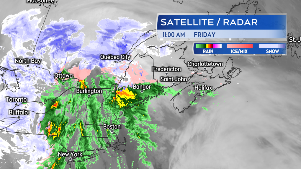 The storm was on the doorstep of the Maritimes Friday morning. Heavy rain, some snow, and strong winds building into afternoon and evening.
Light snow is moving into New Brunswick. with a risk of freezing rain for the St. John River Valley and light rain into Nova Scotia.
Gustier east winds are already present in the southwest of the Maritimes. Easterly gusts of 60 to 80 km/h are present west of Nova Scotia and near the Bay of Fundy coastline in New Brunswick.
Both the intensity of the wind and precipitation will increase moving through Friday afternoon and evening. By 9 p.m. Friday, widespread southeast gusts of 70 to 100 km/h across the Maritimes are expected. Stronger gusts are possible on exposed areas of the coast as well as in northern Inverness County, Cape Breton.
The strong wind is likely to cause some power outages and travel disruption. Marine Atlantic is postponing the late Friday ferries until Saturday and Bay Ferries is also cancelling sailings Friday and Saturday. The Confederation Bridge has posted an advisory that the wind may result in traffic restrictions.
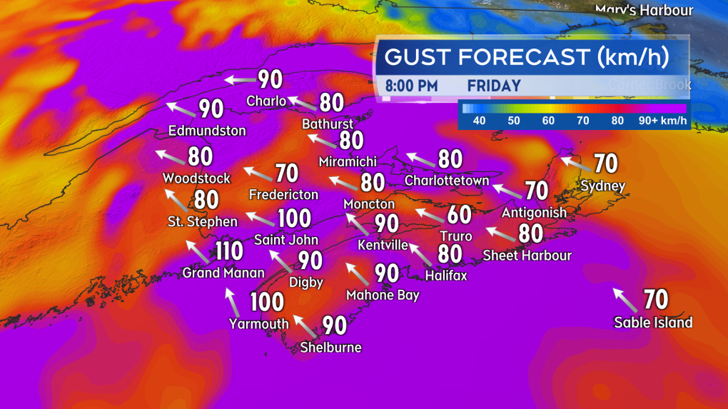 Strong southeast gusts will be widespread across the Maritimes Friday evening and night.
The strongest winds pass by near, and just after, midnight, with the exception of Cape Breton where they could persist into early Saturday morning. A gusty southwest wind will remain across the Maritimes through the day Saturday.
Rainfall warnings remain in effect for Nova Scotia and much of New Brunswick. Rainfall totalling 20 to 50 mm may create runoff from saturated and frozen ground bringing a risk of hydroplaning conditions on roads and some minor flooding. Heavy downpours may be present in the rain and could reduce visibility for periods of time.
Some slushy snow accumulation is expected in northern areas of New Brunswick before a turn to rain Friday evening, which could range from 5 to 15 cm. Snowfall warnings are out for the Mount Carleton – Renous Highway and Bathurst and Chaleur areas.
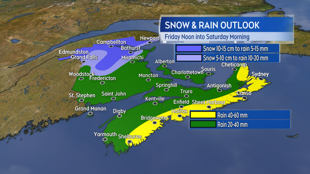 Some accumulating snow is expected for northern areas of New Brunswick but it is largely rain for much of the rest of the Maritimes
Storm surge warnings are now in effect for the Bay of Chaleur and Acadian coastline in northeastern New Brunswick. They caution of large, crashing waves present at high tides near 4 a.m. Saturday and 4 p.m. Saturday. The Atlantic coastline of Nova Scotia from Yarmouth County to Halifax County is also under a storm surge warning calling for large crashing waves that could cause damage at highs tides Friday evening and Saturday morning.
Shopping Trends
The Shopping Trends team is independent of the journalists at CTV News. We may earn a commission when you use our links to shop. Read about us.


CTVNews.ca Top Stories

Los Angeles wildfires burn thousands of homes and other structures
A fast-moving fire broke out in the Hollywood Hills on Wednesday night, threatening one of Los Angeles' most iconic spots as firefighters battled to get under control three other major blazes that killed five people, put 130,000 people under evacuation orders and ravaged communities from the Pacific Coast to inland Pasadena.
Canada could impose tariffs on U.S. steel, orange juice in response to Trump threat
Canadian officials are narrowing a list of American products to target in the event the federal government must respond to U.S. tariffs on Canadian goods, CTV News has confirmed.
Convicted Jan. 6 rioter arrested as fugitive in Whistler, B.C.
An American citizen convicted of participating in the Jan. 6, 2021, riot on Capitol Hill who said he was seeking asylum in Canada has been arrested as a "fugitive from U.S. justice," according to authorities.
'On the front line': Quebec planes and B.C. helicopters battle L.A. wildfires
Water-bombing pilots and crews from Quebec and a British Columbia company have been grappling with high winds and heavy turbulence in the battle against massive Los Angeles wildfires, as Canadians with homes in the area are forced to flee fast-moving flames.
Can the U.S. really make Canada the 51st state?
Talk of Canada becoming the 51st American state has raised an existential question on this side of the border: Could it be done? Could the maple leaf make way to the stars and stripes? According to several experts, it may be possible, but not painless.
Canadians want Ottawa and provinces to team up against Trump tariff threats: Nanos survey
A majority of Canadians want Ottawa and the provinces to team up against U.S. tariff threats, according to a new survey by Nanos Research.
L.A. wildfires continue to devastate area, Canada prepared to offer expertise
A series of wildfires are searing through the Los Angeles area, forcing many to evacuate their homes. Here's everything that happened throughout Jan. 8.
'True when I said it, true today': former Canadian PM Harper pushes back against Trump on social media
Former prime minister Stephen Harper doesn’t find U.S. president-elect Donald Trump’s jibes about Canada becoming the 51st U.S. state very amusing.
Prince William praises his wife Kate as he wishes her a happy birthday
Prince William praised the strength of the Princess of Wales after a turbulent year, offering a 43rd birthday wish on social media on Thursday that described her as an incredible wife and mother.
Toronto
-

Ontario Premier Doug Ford says he is 'OK' after OPP vehicle he was in was 'sideswiped' in Highway 401 collision
Ontario Premier Doug Ford was uninjured after an OPP vehicle he was travelling in was involved in a collision on Highway 401 earlier today.
-
Toronto police arrest one of Canada's most wanted fugitives
One of Canada’s most wanted fugitives, who is the suspect in a fatal double shooting in south Etobicoke more than two years ago, has been arrested.
-
Ontario's so-called 'crypto king' faces new criminal charges in intimate partner violence case
Ontario's self-proclaimed 'crypto king,' Aiden Pleterski is facing charges in an alleged case of intimate partner violence in Vaughan last week.
Calgary
-

What could 'economic force' to merge countries look like for Canadian businesses?
Economists, business leaders and politicians are reacting to U.S. president-elect Donald Trump's comments that he'd use 'economic force' to acquire Canada as the 51st state.
-
'True when I said it, true today': former Canadian PM Harper pushes back against Trump on social media
Former prime minister Stephen Harper doesn’t find U.S. president-elect Donald Trump’s jibes about Canada becoming the 51st U.S. state very amusing.
-
'Extremely triggering': Facebook drug ads cause concern for Calgarian in recovery
A Calgary man who struggled with addiction for more than two decades is questioning why his Facebook account has been showing advertisements for drugs.
Edmonton
-

'This isn't just my mom's story,' says daughter of woman allegedly killed by partner
Abigail Robson says she moved from Nova Scotia to Alberta as a young girl with her mother 10 years ago for a fresh start.
-
ATA warns standardized testing will cause 'stress and anxiety' for kindergarteners
Kindergarteners in the province will receive standardized testing for the first time this month, something the Alberta Teachers’ Association (ATA) says will negatively impact both teachers and students.
-
'It's not substantial': ER doctor says new health-care leadership does nothing to solve current crisis in acute care
Alberta has named two temporary chief executive officers in the shifting acute health-care system, a move one Edmonton emergency medicine specialist says does little to address the current crisis in front-line medicine.
Montreal
-

Two Quebec planes and their crews helping fight devastating L.A. wildfires
A pair of Quebec water bombers and their crews are in California helping fight the massive wildfires tearing through the Los Angeles area
-
Just for Laughs founder's former sister-in-law testified that he sexually assaulted her
Just for Laughs founder Gilbert Rozon’s former sister-in-law testified against him in court Wednesday, alleging he sexually assaulted her in the ‘90s.
-
Legault to join Canadian premiers in negotiation trip to Washington Feb. 12
Quebec Premier François Legault will travel to Washington when President-elect Donald Trump takes office after the latter threatened to impose tariffs on Canadian exports to the United States.
Ottawa
-

Canada as the 51st State: Americans in Watertown, N.Y. react
Watertown, N.Y. is a border city where opinions on Canada potentially becoming the 51st U.S. state are as diverse as the people themselves. New Yorkers living in the city about an hour south of the border are weighing in on the idea, with many sharing mixed emotions.
-
'Not for sale': pushback as Trump's rhetoric escalates
Pushback to Donald Trump's escalating rhetoric continued Wednesday following the president-elect's threat to use economic force to acquire Canada as the 51st state.
-
Group calls on province to ban rat poison after Kanata dog nearly dies
After a dog in Kanata nearly died from ingesting rat poison, a grassroots organization is calling on the provincial government to take action to prevent similar incidents from happening.
London
-

Career change: Dorchester, Ont. chiropractor signs professional soccer contract
Chiropractor Julia Benati is taking a leave from her clinic to pursue a professional contract after signing with the Ottawa Rapid FC franchise in the new Northern Super League (NSL).
-
Public input begins on the future of London's transportation network
Londoners are getting their say in how we’re all going to get around the city over the next 25 years.
-
Why hasn’t London opened warming centres for the homeless?
Warming centres are welcoming people experiencing homelessness in Toronto, but a much lower temperature criteria in London means the temporary spaces are not operating here.
Barrie
-

Over $65,000 in stolen goods seized during Alliston raid: OPP
Ontario Provincial Police executed a search warrant at a Boyne Street property in New Tecumseth, uncovering over $65,000 worth of allegedly stolen items, including a Kubota diesel side-by-side and various tools, dirt bikes, and equipment.
-
Alleged serial ticket scammer 'Todd the Fraud' seeks resolution in case
A Collingwood man nicknamed ‘Todd The Fraud’ by people who say they were defrauded by him in the sale of fake music concert and VIP NHL All-Star Game tickets in Toronto could soon be resolving his Barrie case.
-
Wasaga Beach man plans to live mortgage-free after life-changing lottery win
A Wasaga Beach man is celebrating a life-changing lottery win after saying yes to Encore.
Northern Ontario
-
Ontario Premier Doug Ford says he is 'OK' after OPP vehicle he was in was 'sideswiped' in Highway 401 collision
Ontario Premier Doug Ford was uninjured after an OPP vehicle he was travelling in was involved in a collision on Highway 401 earlier today.
-
Motorist was driving 168 km/h on Hwy. 69, northern Ont. police say
A 21-year-old from Sturgeon Falls has been charged with stunt driving and is accused of exceeding the speed limit by 58 km/h.
-
Ontario has 'strong list' to counter possible Trump tariffs: Ford
Ontario Premier Doug Ford says his government has a “strong list” of possible retaliatory measures if U.S. president-elect Donald Trump moves ahead with imposing tariffs on Canadian goods.
Kitchener
-

Pedestrian dies after crash involving Guelph city bus
A pedestrian has died after a crash involving a city bus in Guelph.
-
At least 60 University of Guelph students sick as 'cluster of illness' hits residence
The University of Guelph is dealing with what they are calling a ‘cluster of illness’ among students living in residence.
-
Faculty strike averted at Ontario colleges as both sides agree to binding arbitration
A strike by faculty at Ontario’s 24 public colleges was averted Wednesday, with both sides reaching an agreement on key points and a promise to resolve outstanding issues in mediation and arbitration.
Windsor
-

Would updated MPAC assessments lead to skyrocketing property tax hikes?
Some residents may assume that a sharp rise in property values would lead to an equivalent increase in property taxes, but that's not the case. Here’s how it works.
-
Ontario Premier Doug Ford says he is 'OK' after OPP vehicle he was in was 'sideswiped' in Highway 401 collision
Ontario Premier Doug Ford was uninjured after an OPP vehicle he was travelling in was involved in a collision on Highway 401 earlier today.
-
'What we're doing is working': More dog parvovirus clinics coming to downtown Windsor as deadly outbreak stabilizes
Three canine parvovirus vaccination clinics are scheduled to take place in downtown Windsor this Friday and Saturday as the number of cases related to a parvo outbreak that began last month levels off.
Winnipeg
-

Winnipeg hospital death to be investigated as critical incident
The recent death of a man waiting for care in a Winnipeg hospital’s emergency department is being investigated as a critical incident.
-
Protesters block heavy equipment from entering Lemay Forest; trees still being cut down
It's full-blown Lemayhem in St. Norbert. On Wednesday morning, protesters blocked the road to Lemay Forest in an effort to stop more tree cutting in the area.
-
Police chief’s remains believed to be found in fire aftermath
The remains of Manitoba First Nation Police Service’s (MFNPS) leader are believed to have been found following a fire at his home.
Regina
-

Saskatchewan RCMP head reflects on the complex challenges, successes of 2024
From the scourge of the addictions crisis to managing recruitment and enforcement in rural areas, the Saskatchewan RCMP had a busy 2024.
-
Regina murder suspect who appeared on national most wanted list arrested
The Regina Police Service (RPS) has arrested a suspect that appeared on Canada's Top 25 Most Wanted list – in relation to a homicide that occurred in May of 2024.
-
Saskatchewan town sees flurry of construction with $30K housing cheque program
An official with a town in southeastern Saskatchewan says its plan to offer $30,000 cheques to anyone building homes in the community is paying off.
Saskatoon
-

'You're killing them inside': Sask. hockey referee blows the whistle on verbal abuse of young officials
A Saskatchewan hockey referee is gaining widespread attention after posting a video on social media telling coaches and parents to “do better.”
-
Sask. man missing since Christmas found dead
A 50-year-old man from Prince Albert, reported missing on Christmas Eve, was found dead Wednesday.
-
Saskatoon residents oppose cell tower precedent
SaskTel is proposing a new cell tower placed on the corner of a Saskatoon park to improve coverage and network capacity, but nearby residents say it’s too close to their homes, and against City of Saskatoon policy.
Vancouver
-

Fewer paramedics on shift as BC Ambulance millions over budget
BC Emergency Health Services is cracking down on overtime in a cost-cutting measure, leaving more ambulances than usual unstaffed as front-line workers fear patients will face even longer delays.
-
B.C. Conservative leader alleges voting irregularities in critical Surrey-Guildford riding
John Rustad, the leader of the B.C. Conservative Party, says his party has uncovered what he calls voting irregularities in the critical Surrey-Guildford riding – where the margin of victory was just 22, and which gave the provincial New Democratic Party its majority.
-
Convicted Jan. 6 rioter arrested as fugitive in Whistler, B.C.
An American citizen convicted of participating in the Jan. 6, 2021, riot on Capitol Hill who said he was seeking asylum in Canada has been arrested as a "fugitive from U.S. justice," according to authorities.
Vancouver Island
-
Fewer paramedics on shift as BC Ambulance millions over budget
BC Emergency Health Services is cracking down on overtime in a cost-cutting measure, leaving more ambulances than usual unstaffed as front-line workers fear patients will face even longer delays.
-
B.C. Conservative leader alleges voting irregularities in critical Surrey-Guildford riding
John Rustad, the leader of the B.C. Conservative Party, says his party has uncovered what he calls voting irregularities in the critical Surrey-Guildford riding – where the margin of victory was just 22, and which gave the provincial New Democratic Party its majority.
-
Convicted Jan. 6 rioter arrested as fugitive in Whistler, B.C.
An American citizen convicted of participating in the Jan. 6, 2021, riot on Capitol Hill who said he was seeking asylum in Canada has been arrested as a "fugitive from U.S. justice," according to authorities.
Kelowna
-

1 hospitalized, residents displaced after Kelowna apartment fire
Firefighters knocked down a blaze on the third floor of a low-rise apartment building near downtown Kelowna Monday afternoon.
-
Lost skiers rescued off B.C. mountain
Search and rescue volunteers in B.C.’s Okanagan successfully reunited two skiers with their family Friday evening.
-
Charges laid after child porn investigation that 'spanned several different countries,' Kelowna RCMP say
Police in Kelowna say an international investigation has led to child pornography charges against a 46-year-old man.


