Weather system stretching from Gulf States to Atlantic Canada continues risk of thunderstorms
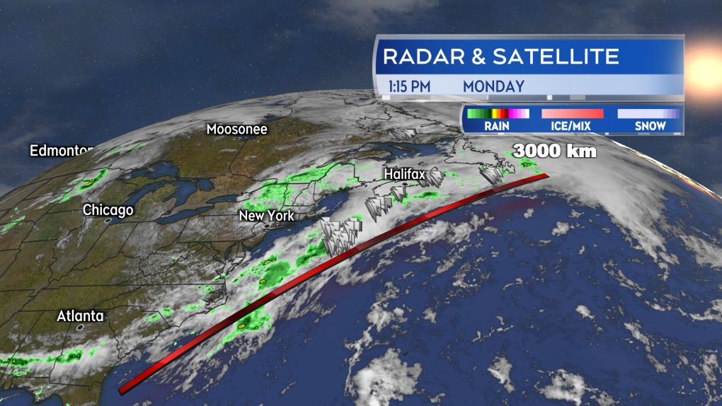
A weather system extending from the Gulf States, up the eastern United States seaboard, and across Atlantic Canada continues to bring periods of showery weather along with a risk of thunderstorms.
 The weather front extends well over 3,000 kilometres in length and is acting like a conveyor belt bringing rounds of showers and thunderstorms up from the subtropical Atlantic.
For Monday afternoon and evening, the chance of thunderstorms is highest in southern New Brunswick and near the Atlantic coastline of Nova Scotia. It is possible that the thunderstorms near the Atlantic coastline of Nova Scotia could hold mostly offshore.
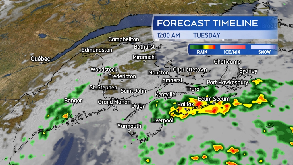
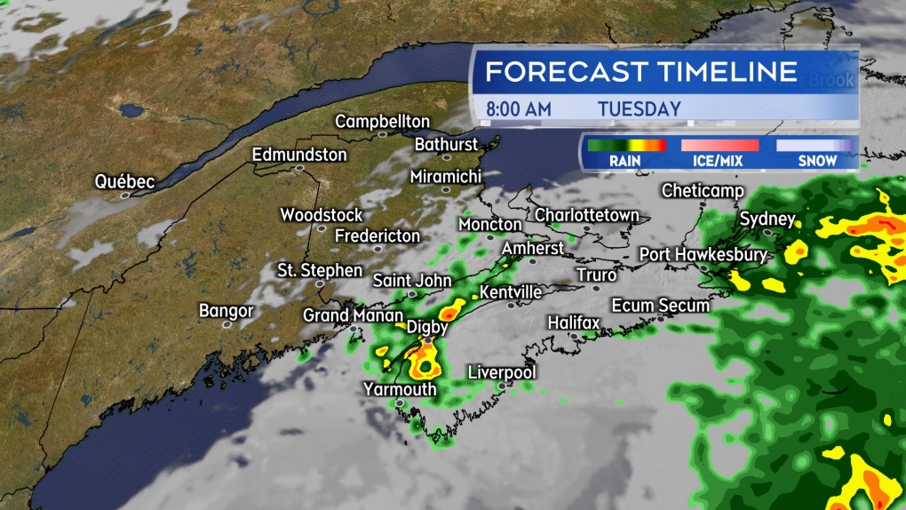
Another round of rain arrives for Nova Scotia late Monday night into Tuesday morning. There is a chance of embedded thunderstorms with that as well. The risk of thunderstorms start around 10 p.m. to midnight near the Atlantic coastline of the mainland. Both eastern Nova Scotia and the southwest of the province with a risk of thunderstorms extending into Tuesday morning.
 Another round of rain is expected to arrive for Atlantic coastal Nova Scotia late Monday night, bringing a further risk of thunderstorms with it.
The weather front is tapping into moisture from the subtropical Atlantic. Downpours producing localized rain totals 50-plus mm are possible with occurring thunderstorms. That increases the chance of hazards such as reduced visibility on roads in the heavier rain, hydroplaning conditions, and localized flooding.
Weather front clears
While slow moving, the area of low pressure and associated weather front is expected to clear the Maritimes on Tuesday. A low chance of showers in southeastern New Brunswick and Prince Edward Island could be possible on Tuesday. Showers are forecast to end in Nova Scotia Tuesday afternoon and early evening.
 Showers with a risk of thunderstorms in eastern and southwestern Nova Scotia Tuesday morning. Remaining showers ending in the region Tuesday afternoon and evening.
A similar weather arrives for the Maritimes on Thursday with rain and showers once again becoming more widespread. A risk of thunderstorms within the rain is also possible. Rain totals are coming in lower for the Thursday wet weather, with a general range of 5 to 20 mm. However, any occurring thunderstorms could produce higher local amounts.
Weekend rain report
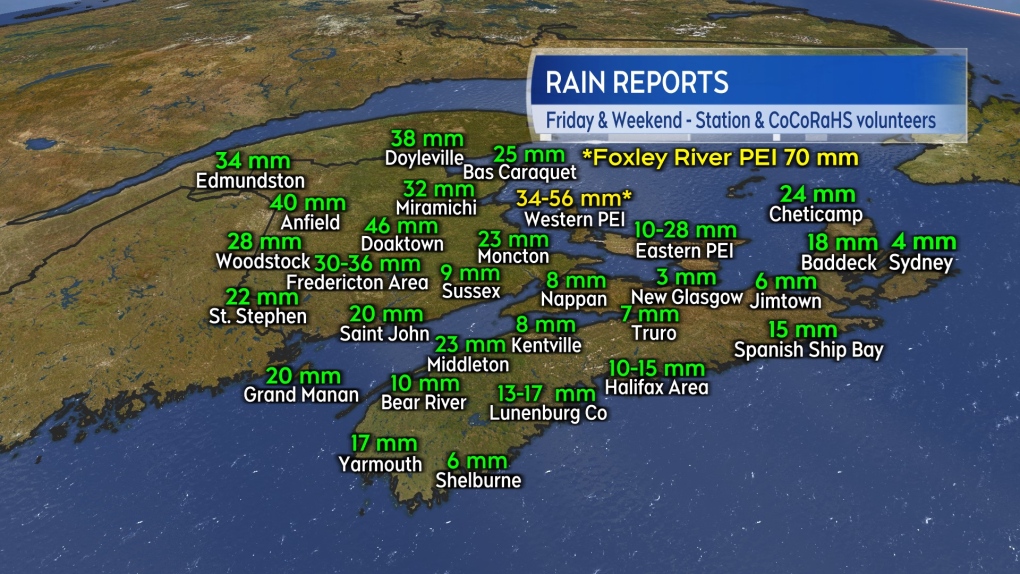
Rain reports over the weekend into Monday morning are highly varied across the Maritimes. Not unusual, given the pockets of downpours and thunderstorms.
Northern and central areas of New Brunswick, as well as western Prince Edward Island, are reporting the most widespread rain totals of more than 30 mm. This report does not include the additional rain expected in the form of showers and thunderstorms Monday afternoon through Tuesday morning.
 Weekend into Monday morning rain reports. These do not include the additional rain expected from further showers and thunderstorms Monday afternoon through Tuesday morning.
CTVNews.ca Top Stories

Donald Trump says he urged Wayne Gretzky to run for prime minister in Christmas visit
U.S. president-elect Donald Trump says he told Canadian hockey legend Wayne Gretzky he should run for prime minister during a Christmas visit but adds that the athlete declined interest in politics.
Historical mysteries solved by science in 2024
This year, scientists were able to pull back the curtain on mysteries surrounding figures across history, both known and unknown, to reveal more about their unique stories.
King Charles III focuses Christmas message on healthcare workers in year marked by royal illnesses
King Charles III used his annual Christmas message Wednesday to hail the selflessness of those who have cared for him and the Princess of Wales this year, after both were diagnosed with cancer.
Mother-daughter duo pursuing university dreams at the same time
For one University of Windsor student, what is typically a chance to gain independence from her parents has become a chance to spend more time with her biggest cheerleader — her mom.
Thousands without power on Christmas as winds, rain continue in B.C. coastal areas
Thousands of people in British Columbia are without power on Christmas Day as ongoing rainfall and strong winds collapse power lines, disrupt travel and toss around holiday decorations.
Ho! Ho! HOLY that's cold! Montreal boogie boarder in Santa suit hits St. Lawrence waters
Montreal body surfer Carlos Hebert-Plante boogie boards all year round, and donned a Santa Claus suit to hit the water on Christmas Day in -14 degree Celsius weather.
Canadian activist accuses Hong Kong of meddling, but is proud of reward for arrest
A Vancouver-based activist is accusing Hong Kong authorities of meddling in Canada’s internal affairs after police in the Chinese territory issued a warrant for his arrest.
New York taxi driver hits 6 pedestrians, 3 taken to hospital, police say
A taxicab hit six pedestrians in midtown Manhattan on Wednesday, police said, with three people — including a 9-year-old boy — transported to hospitals for their injuries.
Azerbaijani airliner crashes in Kazakhstan, killing 38 with 29 survivors, officials say
An Azerbaijani airliner with 67 people onboard crashed Wednesday near the Kazakhstani city of Aktau, killing 38 people and leaving 29 survivors, a Kazakh official said.


