Weather warnings continue as heavy rain brings flash flooding to parts of Nova Scotia
There are reports of flash flooding in parts of Nova Scotia Wednesday due to heavy rainfall and thunderstorms.
Some of the areas that have reported flooding include New Minas, Avonport, Coldbrook, Port Williams, and Wallbrook.
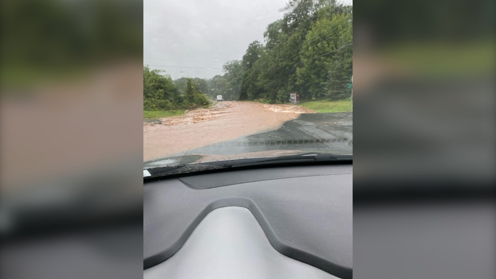 A flooded road is pictured in Greenwich, N.S., on Aug. 30, 2023 due to heavy rain in the region. (Source: REMOKingsCounty)
A cluster of thunderstorms that started at the Digby Neck area of Nova Scotia near 6 a.m. moved up the Annapolis Valley and into the Minas Basin by 10 a.m. The thunderstorms packed rainfall rates near 40 mm/hr, with the weather station at Kentville actually recording 40 mm in one hour. That is a one-in-10 year rainfall rate for the Maritimes, but the third such instance this summer alone. Rain totals produced by those thunderstorms ranged from 50 to 80 mm.
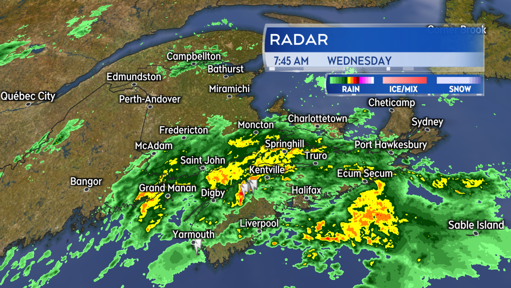 The cluster of thunderstorms that brought flash flooding in areas extending from the Annapolis Valley to the Minas Basin Wednesday morning.
The risk of thunderstorms and downpours within the rain continues through Wednesday afternoon for the Maritimes. Some of the areas at a higher risk of further thunderstorms include coastal areas of the southwest of New Brunswick, the Atlantic coastline of Nova Scotia as well as eastern parts of that province.
Rainfall warnings continue for Nova Scotia, parts of southern New Brunswick, and Kings/Queens Counties of P.E.I. The warnings call for general totals of 50 to 80 mm but potentially higher amounts in thunderstorms. Special weather statements calling for totals of 30 to 45 mm of rain extend into central New Brunswick and Prince County, P.E.I.
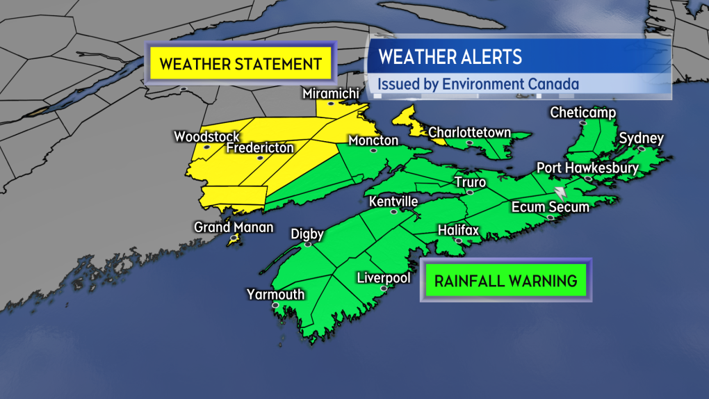 Rainfall warnings and special weather statements continue for the Maritime region. Environment Canada is occasionally issuing severe thunderstorm warnings when specific areas get into the heaviest of downpours.
The risk of downpours and thunderstorms is expected to diminish in western areas of the Maritimes Wednesday evening. The risk will diminish for eastern areas of the Maritimes Wednesday night into very early Thursday morning.
The rain and downpours are a result of a series of weather fronts moving into the Maritimes. While not directly related to Hurricane Franklin, which is far to our south, the hurricane has put a lot of water vapour into the atmosphere and some of that is helping to fuel the heavier rain.


CTVNews.ca Top Stories

Should sex abuse evidence set the Menendez brothers free? A judge will decide
A judge will decide Monday whether new evidence warrants a re-examination of the convictions of Erik and Lyle Menendez in the shotgun murders of their parents in their Beverly Hills home more than 30 years ago.
Second Cup closes Montreal franchise over hateful incident
Second Cup Café has closed two of its franchise locations in Montreal following allegations of hateful remarks and gestures made by the franchisee in a video that was widely circulated online during a pro-Palestinian protest.
Egyptian officials say 17 people are missing after a tourist yacht sank in high waves on Red Sea
At least 17 people are missing after a tourist yacht sank in the Red Sea following warnings about rough seas, Egyptian officials said Monday.
Winnipeg police shoot, kill suspect after officer stabbed in the throat
A Winnipeg Police Service officer is recovering after he was stabbed in the throat Sunday evening.
'A first for everyone': Toronto traffic forces Utah Hockey Club to walk to Leafs game
The Utah Hockey Club got the full Toronto experience Sunday night ahead of their first-ever matchup against the Maple Leafs—bumper-to-bumper traffic that forced the team to walk to the game.
DHL cargo plane crashes and skids into a house in Lithuania, killing Spanish crew member
A DHL cargo plane crashed on approach to an airport in Lithuania's capital and skidded into a house Monday morning, killing a Spanish crew member but not harming anyone on the ground. The cause of the accident is under investigation.
Cargo ship runs aground in St. Lawrence River near Morrisburg, Ont.
A large cargo ship remains stuck in the St. Lawrence River after running aground on Saturday afternoon.
Horse's head and pregnant cow used in 'barbaric' mafia threat in Sicily
The discovery of a severed horse head, and a cow quartered with its bloodied dead calf on top, have rattled a Sicilian town, with authorities treating the incident as a mafia threat.
Legal arguments being heard in London, Ont. court in sex assault case of five hockey players
Lawyers for the players have said their clients plan to defend themselves against the allegations, and all five are expected to plead not guilty.
Shopping Trends
The Shopping Trends team is independent of the journalists at CTV News. We may earn a commission when you use our links to shop. Read about us.


Toronto
-

'A first for everyone': Toronto traffic forces Utah Hockey Club to walk to Leafs game
The Utah Hockey Club got the full Toronto experience Sunday night ahead of their first-ever matchup against the Maple Leafs—bumper-to-bumper traffic that forced the team to walk to the game.
-
Murder suspect arrested in St. Catharines following hours-long standoff
A suspect in a deadly daylight shooting in St. Catharines was arrested over the weekend following an hours-long standoff, police say.
-
Ontario missed interim target for providing hands-on care to long-term care residents
Ontario failed to meet its own legislated target this past year for the average number of hands-on hours of care that long-term care residents receive, a newly updated document shows.
Calgary
-

Mayor Gondek to give post-budget address on city's vision
Mayor Jyoti Gondek will be giving a post-budget on Monday. Her remarks will be the keynote speech at a luncheon hosted by the Calgary Chamber of Commerce.
-
'We need an industry': Crowsnest Pass residents voting on support for new coal mine
It's been more than 40 years since coal was king in the scenic Crowsnest Pass of southwestern Alberta, but a referendum vote Monday could sway a contentious debate on bringing it back.
-
Court hearing legal arguments in sex assault case of five hockey players
A London, Ont., judge is set to hear legal arguments today in the sexual assault case of five members of Canada's 2018 world junior hockey team.
Edmonton
-

Alberta economists predict Canadian consumers will be 'cautious' with holiday spending
With Black Friday sales already in play and with Christmas a month away, the holiday shopping season is underway as Statistics Canada revealed last week the country's inflation rate climbed back up to two per cent in October. But even though the two-per-cent increase is in line with Bank of Canada targets, one Alberta-based economist says Canadians are "going to be very cautious," because while inflation has slowed down, prices haven't gone down.
-
Electric cars a 'hot commodity' in Alberta despite misconceptions
Electric vehicles are off Alberta car lots, despite what experts say are some ongoing misconceptions about the technology.
-
Being part of NHL team for two days 'insane' experience for Edmonton-area girl
An Edmonton-area teen has returned home from the trip of a lifetime.
Montreal
-

'Mixed bag' of wet weather headed to Montreal this week
A 'mixed bag' of precipitation is in store for the Greater Montreal area, according to Environment and Climate Change Canada.
-
Second Cup closes Montreal franchise over hateful incident
Second Cup Café has closed two of its franchise locations in Montreal following allegations of hateful remarks and gestures made by the franchisee in a video that was widely circulated online during a pro-Palestinian protest.
-
Man shot inside Montreal apartment
One man is in hospital after shots were fired inside an apartment building in Montreal’s Mercier–Hochelaga-Maisonneuve borough.
Ottawa
-
 SPECIAL WEATHER STATEMENT
SPECIAL WEATHER STATEMENT First snowfall, freezing rain of the season expected in Ottawa this week
Environment Canada has issued a special weather statement for Ottawa with freezing rain expected to move into the area starting tonight.
-
Cargo ship runs aground in St. Lawrence River near Morrisburg, Ont.
A large cargo ship remains stuck in the St. Lawrence River after running aground on Saturday afternoon.
-
Police lay more charges against pro-Palestinian demonstrators in Ottawa
Three people were arrested during pro-Palestinian demonstrations in Ottawa this weekend.
London
-

Legal arguments being heard in London, Ont. court in sex assault case of five hockey players
Lawyers for the players have said their clients plan to defend themselves against the allegations, and all five are expected to plead not guilty.
-
Two displaced in $200,000 house fire
The London Fire Department was on scene of a house fire in the city on Sunday.
-
Barrie
-

Driver seriously injured after crashing into tree: OPP
An overnight crash in Tiny Township is under investigation, where a car allegedly crashed into a tree and both occupants were taken to hospital.
-
First snowfall hits region
Simcoe Muskoka saw its first signs of snow of the season Sunday morning, with a mix of flurries and rain leading to worsening road conditions and police reporting multiple collisions.
-
Local high school basketball team wins provincial championship
The Maple Ridge Ravens girls’ basketball team won a gold medal at the Girls AAA OFSAA Championships this weekend in Brampton, defeating the Mother Teresa Spartans 46-42 in comeback fashion.
Northern Ontario
-

Police investigating death of a North Bay, Ont., man as a homicide
The Almaguin Highlands detachment of the Ontario Provincial Police is treating the recent death of a North Bay man as a homicide.
-
Winter weather advisory in effect for most of northeastern Ont.
Environment Canada has issued a winter weather advisory for areas in and around Greater Sudbury, North Bay, Sault Ste. Marie and Timmins.
-
Northern Ont. First Nation files claim against Ontario and Newmont mining
Taykwa Tagamou Nation, a Cree First Nation located within Treaty 9, has filed a statement of claim against the Province of Ontario and Newmont, a mining company that owns properties in Timmins.
Kitchener
-

Candlelight vigil in Kitchener honours Holodomor victims and marks 1,000 days of Ukraine-Russia war
A Saturday evening vigil brought together community members to honour the victims of the Holodomor and reflect on 1,000 days since Russia’s invasion of Ukraine.
-
Kitchener auto repair shop hosts fundraiser for children with disabilities, joined by hockey legend Wendel Clark
An auto repair shop based in Kitchener held a special fundraiser Saturday to help children and youth with physical disabilities, with former Maple Leafs captain Wendel Clark in attendance.
-
Colleges and universities face job cuts, deficits amid international student cap
Groups representing post-secondary institutions say this may just be the tip of the iceberg, as dramatic drops in international student enrolment exacerbate some schools' existing budget shortfalls.
Windsor
-

'Active investigation' underway in Windsor
Windsor police are on the scene of what's being called an, "active investigation." "Expect a sustained police presence in the area," read a post on social media.
-
'Fail to remain' being investigated in Tecumseh
Around 3 p.m. on Sunday, OPP were dispatched to a vehicle rollover collision involving a passenger vehicle on Lanoue Street near Rygate Drive.
-
CPKC Holiday Train coming to Chatham-Kent, Windsor-Essex
If you were hoping to see the CPKC Holiday Train this year, you’re in luck! The train is chugging through Canada and the U.S., stopping in Chatham-Kent and Windsor-Essex on Monday.
Winnipeg
-

Winnipeg police shoot, kill suspect after officer stabbed in the throat
A Winnipeg Police Service officer is recovering after he was stabbed in the throat Sunday evening.
-
'I had no idea that they even existed': Family reunites with 80-year-old letters hidden in Winnipeg home
The family of a soldier who fought during the Second World War has been reunited with letters written to him 80 years ago.
-
Parts of Manitoba under snowfall warning; up to 25 cm expected
Environment and Climate Change Canada (ECCC) has issued a snowfall warning for parts of Manitoba, with snowfall totals between 15 and 25 cm expected.
Regina
-

Dinosaur discovery reveals more about ancient Saskatchewan
Researchers from McGill University have discovered a first of its kind fossil specimen for Saskatchewan.
-
Regina police searching for answers after man injured by firearm
The Regina Police Service (RPS) is searching for information after a man was injured in a firearm- related incident early Saturday morning.
-
Winnipeg police shoot, kill suspect after officer stabbed in the throat
A Winnipeg Police Service officer is recovering after he was stabbed in the throat Sunday evening.
Saskatoon
-

Saskatoon schools will be closed Monday following heavy snowfall
Saskatoon Public Schools (SPS) has announced that all schools will be closed on Monday due to heavy snowfall and hazardous road conditions.
-
Saskatoon digs out after 25 centimetre snowfall
Saskatoon residents are digging out from another major snowfall that blanketed the city overnight.
-
'I'm excited to take it on': Saskatoon businesses weigh in on GST exemption
Some local businesses say the federal government’s recent plan to pull back GST on several items is a positive initiative, but it should have been rolled out earlier in the holiday season.
Vancouver
-

B.C. health minister promises revamped approach to overdose crisis after addictions portfolio scrapped
British Columbia's new health minister says she's aiming for more treatment beds and fewer deaths in a revamped approach to the province's drug overdose crisis.
-
Woman left ‘screaming for help’ after car journey with male driver, say Abbotsford police
Abbotsford police are requesting dash cam video and witness information after a frightening car journey with an unknown male left a woman “extremely shaken up,” police say.
-
Hypothermic man found submerged and ‘clinging to piling’ in Cowichan Bay water rescue
A boater is grateful for the services of local rescue groups after being left stranded in the cold waters of Cowichan Bay after his vessel capsized.
Vancouver Island
-
B.C. health minister promises revamped approach to overdose crisis after addictions portfolio scrapped
British Columbia's new health minister says she's aiming for more treatment beds and fewer deaths in a revamped approach to the province's drug overdose crisis.
-
Hypothermic man found submerged and ‘clinging to piling’ in Cowichan Bay water rescue
A boater is grateful for the services of local rescue groups after being left stranded in the cold waters of Cowichan Bay after his vessel capsized.
-
B.C. man awarded $800K in damages after being injured by defective bear banger
A B.C. man has been awarded nearly $800,000 in damages as compensation for injuries he sustained from a defective bear banger, according to a recent court decision.
Kelowna
-

Man in hospital following targeted shooting in Kamloops
Police are appealing for information on a targeted shooting that resulted in the hospitalization of a man in Kamloops.
-
Police cleared of fault in fatal 2023 crash in B.C.'s Interior
British Columbia's independent police watchdog has cleared officers of wrongdoing in a crash where three people were killed south of Kamloops in July of last year.
-
B.C. woman sentenced for stealing $14K in funds raised for schoolkids
A B.C. woman who stole more than $14,000 in volunteer-raised funds that were supposed to be spent on school supplies and programs – including hot meals for vulnerable kids – won't spend any time in jail.


