Wednesday storm to bring snow, rain, and strong winds to the Maritimes
Parts of the South Shore of Nova Scotia picked up 10 to 20 cm of snow on Sunday. A few reports from Yarmouth County show totals closer to 25 cm.
It was only southwestern parts of Nova Scotia impacted by the storm system due to it tracking south and east of the province. The same can’t be said for the next low pressure system that will impact the region Wednesday.
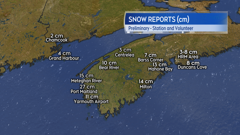 Volunteer snow reports for Sunday into Monday morning.
The next storm is currently in Texas. Over the next two days, it will take a path into the northeastern United States and then pass the Maritimes either through northern New Brunswick or the St. Lawrence River Valley. This places the Maritimes on the eastern side of the storm, which will be characterized by a period of snow turning to rain along with a high and gusty southeast wind.
Snow arrives first Wednesday morning in western New Brunswick and western Nova Scotia. Then, snow turning to rain spreads east across the Maritimes for the afternoon. For many areas, the snow should be limited to 5 to 10 cm before a turn to rain. Higher snow and ice pellet accumulation is possible for parts of central and northern New Brunswick, 10 to 25 cm. The rain will range 10 to 30 mm. Melting snow and ice along with the frozen ground will lead to more water runoff than the same amount of rain during the milder months. If you can, it would be a good idea to clear any snow/ice blocked drainage on your property to help with drainage.
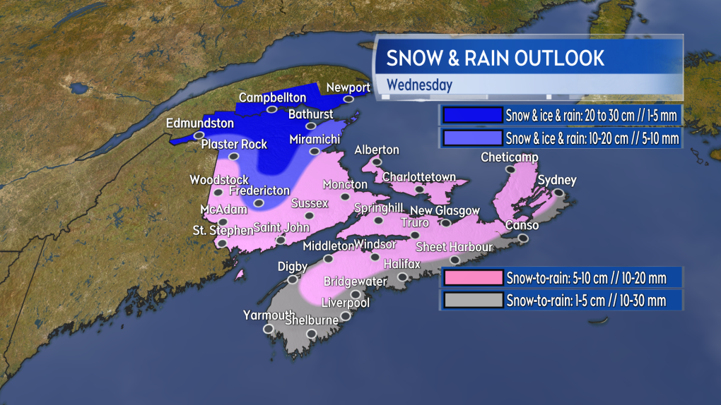 The Wednesday storm brings snow turning to rain. The most snow and ice pellet accumulation will be in parts of central and northern New Brunswick.
Wind is going to be an issue. A round of southeast gusts peaking as high as 80 to 110 km/h is expected to come across southern New Brunswick, Nova Scotia, and Prince Edward Island on Wednesday. Peak gusts in northern Inverness County, Cape Breton, will reach 130 km/h Wednesday evening and night due to the topography of the Highlands. Any time we have winds that high there is going to be a risk of power outages and possible delays in travel services, such as the ferries.
Weather conditions improve Wednesday night as snow and rain ends and the wind begins to diminish.
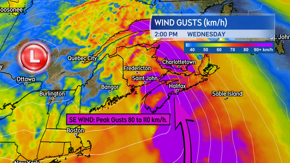 A high and gusty southeast wind will accompany the mix of precipitation for a large part of the Maritimes.
Environment Canada has issued special weather statements for all three Maritimes provinces advising of the storm and the mix of precipitation and strong winds it is expected to bring. The same storm has triggered a winter storm watch in Ontario and Quebec, which are on the snowier, western side of the system.
I’ll have daily updates, timelines, and regional weather conditions on CTV News Atlantic programming and at ctvnewsatlantic.ca.
Shopping Trends
The Shopping Trends team is independent of the journalists at CTV News. We may earn a commission when you use our links to shop. Read about us.


CTVNews.ca Top Stories

BREAKING
BREAKING 'Canadians deserve a real choice': Justin Trudeau resigning, prorogues Parliament
Prime Minister Justin Trudeau is stepping down as Liberal leader, and is proroguing Parliament as the Liberal Party of Canada embarks on the journey to replace him.
WATCH LIVE
WATCH LIVE Justin Trudeau resigns as Liberal leader: Follow live updates
Prime Minister Justin Trudeau has stepped down as Liberal leader. Follow along for live updates from CTVNews.ca.
'Together, what a great nation it would be': Donald Trump, Elon Musk react to Justin Trudeau's resignation
Amid news of Prime Minister Justin Trudeau's resignation as leader of the Liberal party on Monday morning, reactions from prominent figures began piling in.
Justin Trudeau is resigning, what will be his legacy? A look back at key political eras
In a seismic political move, Justin Trudeau has announced his intention to step down as leader of the Liberal Party of Canada and prime minister, once his successor is named. This decision comes after more than nine years in the country's top job and nearly 12 years at the helm of his party.
Justin Trudeau resignation: Here's what he said in Ottawa today
Prime Minister Justin Trudeau delivered a speech about his political future Monday morning outside Rideau Cottage in Ottawa. Here's the message he delivered to Canadians.
Alberta government signs new oil and gas agreement with Enbridge
The Alberta government has signed an agreement with Enbridge that Premier Danielle Smith says will increase exports of the province's heavy oil to the United States.
Judge condemns murder trial delay, asks lawyers to 'turn around' and look at the public 'we serve'
A Saskatoon murder trial opened on Monday with the judge sharply criticizing the time it’s taken to get to trial.
Doug Ford snaps back at Donald Trump's Canada taunts with offer to 'buy Alaska'
Ontario Premier Doug Ford has snapped back at Donald Trump’s frequent taunts about treating Canada as a U.S. state with a counterproposal: buying Alaska.
Canadian alleged drug lord Ryan Wedding still has access to 'network of hitmen': U.S. prosecutors
U.S. prosecutors are seeking additional protections to keep the identities of confidential informants and co-operating witnesses hidden in the case against Ryan James Wedding, as the search continues for the Canadian ex-Olympian and alleged drug lord.
Toronto
-
BREAKING
BREAKING 'Canadians deserve a real choice': Justin Trudeau resigning, prorogues Parliament
Prime Minister Justin Trudeau is stepping down as Liberal leader, and is proroguing Parliament as the Liberal Party of Canada embarks on the journey to replace him.
-
Doug Ford snaps back at Donald Trump's Canada taunts with offer to 'buy Alaska'
Ontario Premier Doug Ford has snapped back at Donald Trump’s frequent taunts about treating Canada as a U.S. state with a counterproposal: buying Alaska.
-
Canadian alleged drug lord Ryan Wedding still has access to 'network of hitmen': U.S. prosecutors
U.S. prosecutors are seeking additional protections to keep the identities of confidential informants and co-operating witnesses hidden in the case against Ryan James Wedding, as the search continues for the Canadian ex-Olympian and alleged drug lord.
Calgary
-
BREAKING
BREAKING 'Canadians deserve a real choice': Justin Trudeau resigning, prorogues Parliament
Prime Minister Justin Trudeau is stepping down as Liberal leader, and is proroguing Parliament as the Liberal Party of Canada embarks on the journey to replace him.
-
Alberta government signs new oil and gas agreement with Enbridge
The Alberta government has signed an agreement with Enbridge that Premier Danielle Smith says will increase exports of the province's heavy oil to the United States.
-
Canadian oil stocks climb as industry absorbs news of Trudeau resignation
Canadian oil and gas stocks climbed Monday as the country's energy sector absorbed the news of Prime Minister Justin Trudeau's resignation.
Edmonton
-
BREAKING
BREAKING 'Canadians deserve a real choice': Justin Trudeau resigning, prorogues Parliament
Prime Minister Justin Trudeau is stepping down as Liberal leader, and is proroguing Parliament as the Liberal Party of Canada embarks on the journey to replace him.
-
Teen charged in stabbing at Alberta recreation centre
A teen boy has been charged after a stabbing at a northern Alberta recreation centre.
-
Large, slow-moving load to cause delays between Edmonton and Fort McMurray
A large, heavy load will travel between Edmonton and Fort McMurray starting on Tuesday.
Montreal
-

'It was the right decision': Quebec politicians react to Trudeau resignation
Elected officials in Quebec were quick to react to the major announcement in Ottawa Monday about Prime Minister Justin Trudeau and the path forward for the federal Liberal Party.
-
Man, 27, injured in possible stabbing in Plateau-Mont-Royal
A 27-year-old man was sent to hospital with serious injuries after a possible stabbing in broad daylight Monday afternoon.
-
One dead after head-on collision on Highway 40 East
Quebec provincial police (SQ) are investigating after a head-on collision left one person dead on Highway 40 eastbound on Monday morning.
Ottawa
-
BREAKING
BREAKING 'Canadians deserve a real choice': Justin Trudeau resigning, prorogues Parliament
Prime Minister Justin Trudeau is stepping down as Liberal leader, and is proroguing Parliament as the Liberal Party of Canada embarks on the journey to replace him.
-
Ottawa's new north-south O-Train opens to the public
A large crowd gathered at Bayview Station just before 6 a.m. for a chance to be the first person to ride on the new north-south Line 2 Monday morning. The new north-south Line 2 and Line 4 runs from Bayview Station to Riverside South, with a link to the Ottawa International Airport.
-
Meet the winners of the CHEO Dream of a Lifetime Lottery grand prize
Tracey Lavergne of Woodlawn, Ont. is starting off the new year with a new Minto Dream Home in Manotick, the grand prize in the CHEO Dream of a Lifetime Lottery.
London
-

Body found on Lake Erie shoreline prompts death investigation
Elgin County OPP are investigating after a deceased individual was discovered on the shoreline of Lake Erie in the township of Malahide.
-
Goderich arena closed due to 'significant safety concerns'
At a standing room only meeting of Goderich’s Memorial Arena Task Force on Monday frustrated members of the public heard about council’s January 3 decision to close the Memorial Arena until further notice.
-
BREAKING
BREAKING 'Canadians deserve a real choice': Justin Trudeau resigning, prorogues Parliament
Prime Minister Justin Trudeau is stepping down as Liberal leader, and is proroguing Parliament as the Liberal Party of Canada embarks on the journey to replace him.
Barrie
-

Border officers arrest man accused of smuggling banned firearms into Canada
A man from Aurora, Ont. is facing multiple weapons-related charges after Canadian Border Services Agency (CBSA) officers intercepted packages reportedly containing various prohibited firearms.
-
Newly licensed G driver charged with stunt driving after road test: OPP
Provincial police say a newly licensed motorist was “hot off the road test” on Sunday when an officer conducted a traffic stop.
-
Two high-end vehicles stolen in two days
OPP looking for both a Hummer and Jeep Gladiator taken over the weekend.
Northern Ontario
-
BREAKING
BREAKING 'Canadians deserve a real choice': Justin Trudeau resigning, prorogues Parliament
Prime Minister Justin Trudeau is stepping down as Liberal leader, and is proroguing Parliament as the Liberal Party of Canada embarks on the journey to replace him.
-
Province boosts Sudbury's annual funding by $2.7M
The City of Greater Sudbury is one of more than 300 municipalities receiving an increase to their annual provincial funding this year.
-
Driver charged after asleep at the wheel complaint
A traffic complaint about a man asleep at the wheel at an intersection has resulted in impaired driving charges being laid against a northern Ontario man.
Kitchener
-

New threshold for reporting collisions in Ontario
Ontario has increased the threshold dictating when drivers are required to report a collision to police.
-
BREAKING
BREAKING 'Canadians deserve a real choice': Justin Trudeau resigning, prorogues Parliament
Prime Minister Justin Trudeau is stepping down as Liberal leader, and is proroguing Parliament as the Liberal Party of Canada embarks on the journey to replace him.
-
Canadian alleged drug lord Ryan Wedding still has access to 'network of hitmen': U.S. prosecutors
U.S. prosecutors are seeking additional protections to keep the identities of confidential informants and co-operating witnesses hidden in the case against Ryan James Wedding, as the search continues for the Canadian ex-Olympian and alleged drug lord.
Windsor
-

Three gunpoint robbery suspects sought, one arrested
Windsor police officers have arrested one suspect and they are looking for three others after an armed robbery on University Avenue.
-
'He won't be a John Doe anymore': OPP use new DNA testing to solve 21-year-old cold case
OPP have used new DNA technology to solve a 21-year-old cold case near Amherstburg, Ont. The new testing has led to the identification of the remains of a man found in 2003.
-
Structure fire deemed illegal open air burn
Windsor fire officials determined a structure fire was an illegal open air burn.
Winnipeg
-
BREAKING
BREAKING 'Canadians deserve a real choice': Justin Trudeau resigning, prorogues Parliament
Prime Minister Justin Trudeau is stepping down as Liberal leader, and is proroguing Parliament as the Liberal Party of Canada embarks on the journey to replace him.
-
Man charged with voyeurism at Winnipeg fitness facility
A 26-year-old man has been charged with voyeurism after he allegedly snapped photos of a child undressing in a change room at a Winnipeg fitness facility.
-
'Absolutely devastating': Southern Manitoba golf course clubhouse burns for second time in 4 years
A golf course clubhouse in Morden, Man. went up in flames Sunday for the second time in less than four years, and mere days after its reopening from the previous fire was celebrated.
Regina
-

Saskatchewan politicians react to Trudeau's resignation announcement
Following Prime Minister Justin Trudeau’s resignation announcement on Monday, reaction from politicians around the world quickly began to circulate, including in Saskatchewan.
-
'Everything I've ever dreamed of': Regina Cougars curling to represent Canada at World University Games
The University of Regina Men's Curling team is preparing for the international stage as they gear up as Team Canada for the 2025 FISU Winter World University Games.
-
Regina police arrest 2 after robbery at gun point
Regina police have charged two people after they say a person was held at gun point and robbed early Saturday morning on the 1400 block of Cameron Street.
Saskatoon
-

Judge condemns murder trial delay, asks lawyers to 'turn around' and look at the public 'we serve'
A Saskatoon murder trial opened on Monday with the judge sharply criticizing the time it’s taken to get to trial.
-
Province calling for prospective builders on new Sask. Polytech campus in Saskatoon
The province is putting out the call to prospective builders for a major project on the new Saskatchewan Polytechnic campus planned in Saskatoon.
-
Saskatoon police seek man in connection with weekend stabbing
Saskatoon police are asking the public for tips after a man was stabbed outside a 22nd Street business over the weekend.
Vancouver
-
BREAKING
BREAKING 'Canadians deserve a real choice': Justin Trudeau resigning, prorogues Parliament
Prime Minister Justin Trudeau is stepping down as Liberal leader, and is proroguing Parliament as the Liberal Party of Canada embarks on the journey to replace him.
-
Vancouver Canucks star defenceman Hughes a game-time decision vs. Montreal Canadiens
The injury-plagued Vancouver Canucks may get a crucial piece back in their lineup when they visit the Montreal Canadiens on Monday.
-
Victoria police cleared of wrongdoing in crash that killed 24-year-old taxi driver
British Columbia's police oversight agency has cleared Victoria police officers of wrongdoing after an attempted traffic stop on a city street led to the death of an innocent man last year.
Vancouver Island
-

Victoria police cleared of wrongdoing in crash that killed 24-year-old taxi driver
British Columbia's police oversight agency has cleared Victoria police officers of wrongdoing after an attempted traffic stop on a city street led to the death of an innocent man last year.
-
BREAKING
BREAKING 'Canadians deserve a real choice': Justin Trudeau resigning, prorogues Parliament
Prime Minister Justin Trudeau is stepping down as Liberal leader, and is proroguing Parliament as the Liberal Party of Canada embarks on the journey to replace him.
-
Mounties search for suspects after cash stolen from bank in Nanaimo, B.C.
Mounties are searching for two suspects who allegedly stole an undisclosed amount of cash from a bank on Vancouver Island.
Kelowna
-

Lost skiers rescued off B.C. mountain
Search and rescue volunteers in B.C.’s Okanagan successfully reunited two skiers with their family Friday evening.
-
Charges laid after child porn investigation that 'spanned several different countries,' Kelowna RCMP say
Police in Kelowna say an international investigation has led to child pornography charges against a 46-year-old man.
-
Mounties investigate discovery of 'very small pipe bomb' in Kamloops, B.C.
Mounties are investigating and appealing for witnesses after an explosive device was discovered Wednesday on a beach in Kamloops, B.C.


