Wind chill explained and what to expect late this week in the Maritimes
There is going to be a lot of weather talk about wind chill in the Maritimes Friday night into Saturday. A blast of Arctic air will combine with what are expected to be northwest gusts of 60 to 80 km/h Friday night into Saturday to produce a wind chill making it feel -35 degrees or colder for parts of all three Maritime provinces. A wind chill making it feel -35 or colder for two or more hours is the criteria for an extreme cold warning in the Maritimes. Nova Scotia and P.E.I. haven’t had an extreme cold warning since 2015. The last one issued in New Brunswick was Jan 31-Feb 1, 2022.
So what is wind chill and why does it matter?
Our bodies lose heat to colder air via convection, which is the primary mechanism of heat transfer in gases such as our atmosphere. When we step outside into colder air, we immediately start to lose heat from exposed skin at a high rate. After a period of time, a thin, insulating layer of air develops near our skin and while we continue to lose body heat the rate at which that happens slows.
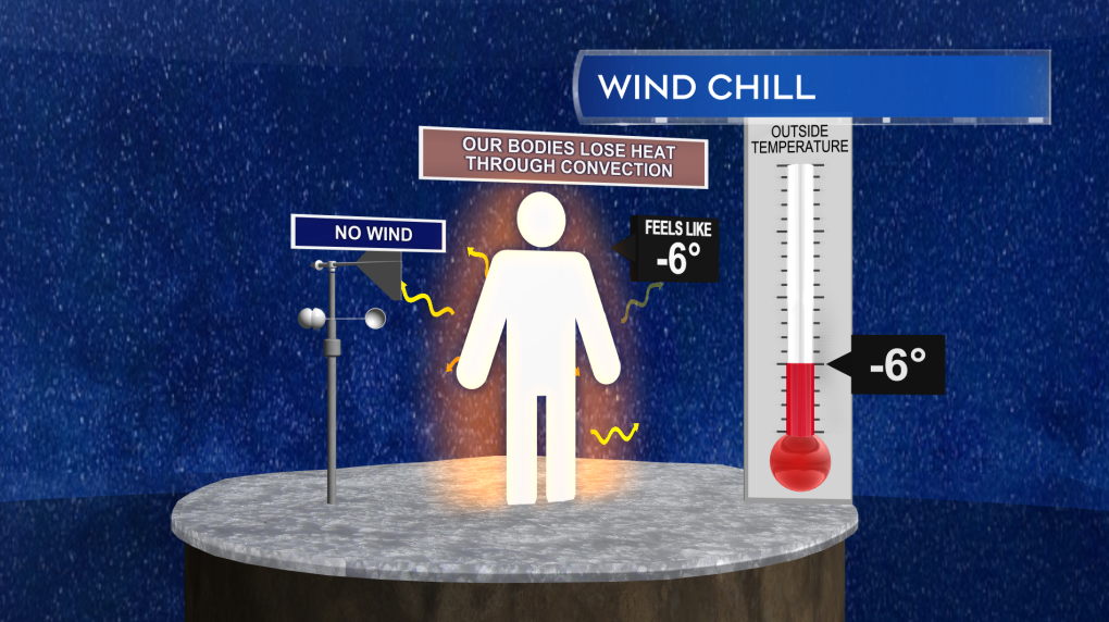 Without wind present, a thin, insulating layer of air forms near our skin as we lose body heat to colder air.
If wind is present, it will continuously disrupt or blow away that thin, insulating layer or air. That keeps the rate of heat loss from our body at a higher rate. Wind chill is a calculation of what the air temperature would have to be in order to have that higher rate of heat loss without the wind present. In the example I’m showing here, it would take a calculated air temperature of -14 C with no wind to replicate the expected rate of heat loss with an air temperature of -6 C and a 30 km/h wind. If you’d like to explore wind chill calculations for different temperatures and wind speeds, you can do so here.
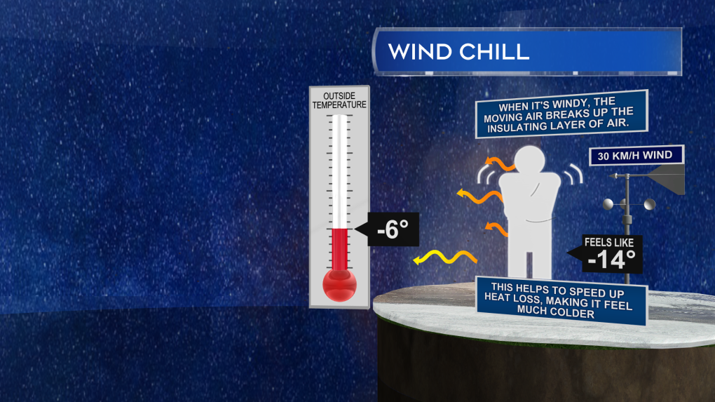 With wind present, the thin, insulating layer of air is continuously disrupted, increasing the rate of heat loss to the environment. The equivalent air temperature without any wind that would match that rate of heat loss is known as wind chill.
As for why wind chill matters: At wind chill values making it feel -28 or colder there is an increased risk of frostbite to exposed skin. With a wind chill of -28 to -39 exposed skin can freeze in 10 to 30 minutes. With a wind chill of -40 to -47 that freeze can take place in as little as 5 to 10 minutes. Hypothermia is of course also a risk in that type of cold, unless properly dressed as well. You can find a detailed breakdown of the health hazards associated with extreme cold and wind chill here.
It’s Canada, it’s winter, we get cold, so why all the weather talk? Well, this combination of Arctic air and wind is more extreme than what we have to typically content with. The low temperatures Friday night into Saturday morning may be enough to challenge some of the longer-standing records for cold for a Feb. 4 in the Maritimes. The National Weather Service office in Caribou, Maine, also noted in a discussion that the air temperature aloft in the atmosphere at a height of 1,500 metres may challenge the standing record they have in more than 70 years of recorded data from weather balloon launches at the site. That standing record is -39.4 C with some of the current forecast guidance suggesting it could be -40 C or colder this Friday night at that height in the atmosphere.
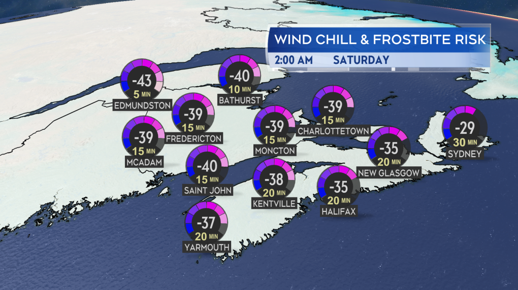 Forecast guidance into potential wind chill in the Maritimes Friday night into Saturday morning.
Our surface temperatures won’t match up to that colder air aloft. However, as mentioned above, the wind chill does look like it will approach the warning criteria. Below you can find a map with some guidance on possible wind chill values as we move into early Saturday morning. The wind chill is expected to be particularly bad in northern areas of New Brunswick. Remember that those wind chill values are calculated off of expected air temperature and wind speed. Should we get a change in the expected conditions the wind chill will change as well.
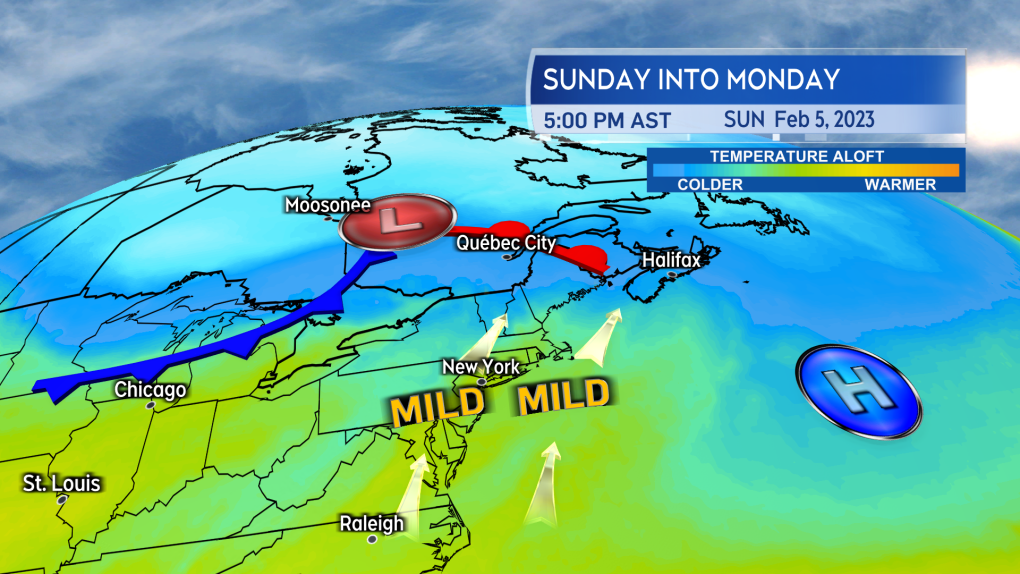 A southerly wind will setup between high pressure to the east and low pressure to the west Sunday into Monday. That will return milder air up the U.S. eastern seaboard and into the Maritimes.
Thankfully, this snap of cold is not a long duration event. We will be in the worst of the cold Friday night through Saturday. Temperatures and wind chill moderate through the day Sunday into Monday. That happens as a southerly wind develops and returns milder air from the U.S. eastern seaboard.
CTVNews.ca Top Stories

Donald Trump says he urged Wayne Gretzky to run for prime minister in Christmas visit
U.S. president-elect Donald Trump says he told Canadian hockey legend Wayne Gretzky he should run for prime minister during a Christmas visit but adds that the athlete declined interest in politics.
Historical mysteries solved by science in 2024
This year, scientists were able to pull back the curtain on mysteries surrounding figures across history, both known and unknown, to reveal more about their unique stories.
King Charles III focuses Christmas message on healthcare workers in year marked by royal illnesses
King Charles III used his annual Christmas message Wednesday to hail the selflessness of those who have cared for him and the Princess of Wales this year, after both were diagnosed with cancer.
Mother-daughter duo pursuing university dreams at the same time
For one University of Windsor student, what is typically a chance to gain independence from her parents has become a chance to spend more time with her biggest cheerleader — her mom.
Thousands without power on Christmas as winds, rain continue in B.C. coastal areas
Thousands of people in British Columbia are without power on Christmas Day as ongoing rainfall and strong winds collapse power lines, disrupt travel and toss around holiday decorations.
Ho! Ho! HOLY that's cold! Montreal boogie boarder in Santa suit hits St. Lawrence waters
Montreal body surfer Carlos Hebert-Plante boogie boards all year round, and donned a Santa Claus suit to hit the water on Christmas Day in -14 degree Celsius weather.
Canadian activist accuses Hong Kong of meddling, but is proud of reward for arrest
A Vancouver-based activist is accusing Hong Kong authorities of meddling in Canada’s internal affairs after police in the Chinese territory issued a warrant for his arrest.
New York taxi driver hits 6 pedestrians, 3 taken to hospital, police say
A taxicab hit six pedestrians in midtown Manhattan on Wednesday, police said, with three people — including a 9-year-old boy — transported to hospitals for their injuries.
Azerbaijani airliner crashes in Kazakhstan, killing 38 with 29 survivors, officials say
An Azerbaijani airliner with 67 people onboard crashed Wednesday near the Kazakhstani city of Aktau, killing 38 people and leaving 29 survivors, a Kazakh official said.


