Winter storm watch issued in Nova Scotia as heavy snow likely for Monday
 A pedestrian makes their way through wind and sleet in Halifax, Wednesday, Jan. 10, 2024. THE CANADIAN PRESS/Darren Calabrese
SNOW POTENTIAL
A low pressure system in the southern U.S. will move to the eastern seaboard on Sunday. The system will then strengthen as it moves northward to pass just by the southwest of Nova Scotia on Monday.
It's a good setup for a heavy snowfall for Nova Scotia. Not only will the low-pressure system pack a lot of moisture, but the path keeps colder air in place for Nova Scotia. Both necessary for a heavier snow with less mixing in of ice pellets or rain.
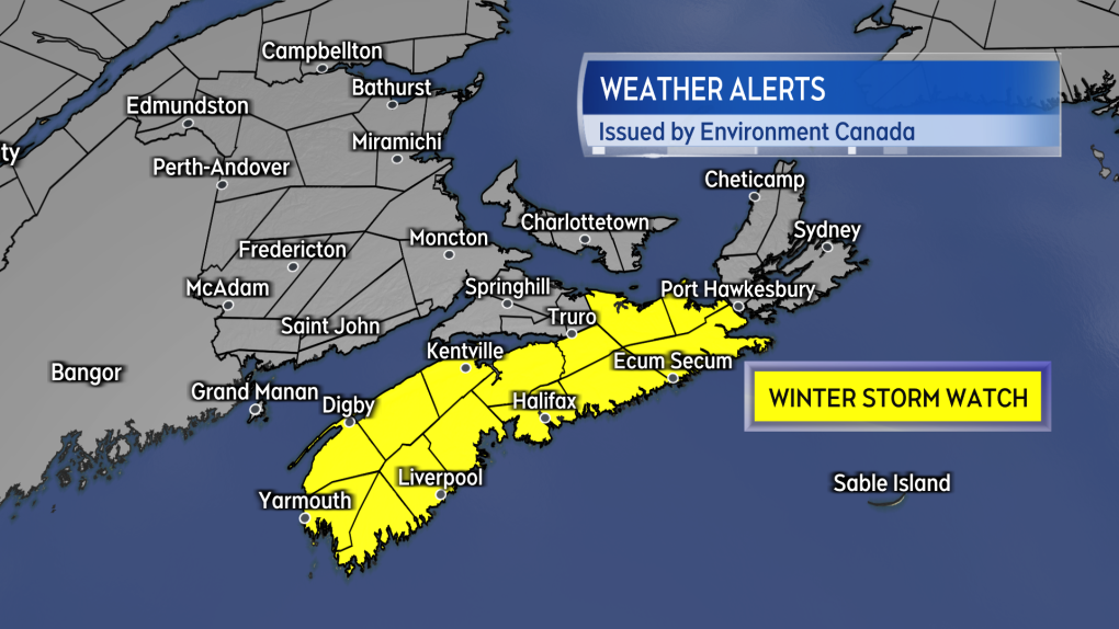 A Winter Storm Watch issued by Environment Canada for Nova Scotia Saturday afternoon.
WINTER STORM WATCH
Saturday afternoon Environment Canada issued a Winter Storm Watch for much of Nova Scotia, excluding Cape Breton and parts of Cumberland/Colchester Counties where the snow could be lighter.
The watch advises on a general 15 to 25 cm of snow possible Sunday overnight through Monday. The snow accompanied by a northeast wind gusting 60 to 70 km/h except up to 90 km/h on exposed areas of the coast.
The weather agency advises that "visibility may be suddenly reduced at times in heavy snow. Poor weather conditions may contribute to transportation delays. There may be a significant impact on rush hour traffic in urban areas."
 Snow, heavy at times, may be falling across most of Nova Scotia by Monday morning.
TIMING AND AMOUNTS
Snow is expected to reach the southwestern corner of Nova Scotia just after midnight Sunday into Monday. By Monday morning the snow will have developed across most of Nova Scotia. A lighter snowfall or flurries is possible on Monday in southern and eastern New Brunswick along with Prince Edward Island.
The snow gradually eases to flurries in Nova Scotia Monday afternoon into Monday evening. The wind remains high and gusty through that time, easing Monday night into Sunday morning. That means that areas of drifting snow will be possible even as the snow begins to ease and end.
It is mainland Nova Scotia that is most likely to pick up snow amounts ranging 15 to 25 cm. I would also include Richmond and Cape Breton Counties with a chance of reaching the 15 cm mark.
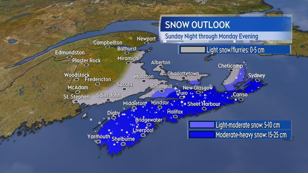 A general 15 to 25 cm of snow likely for a large area of Nova Scotia. The snow becoming lighter for northern parts of the mainland and parts of Cape Breton.
SUMMARY
Be sure to continue to check in on the Monday forecast and any further alerts issued by Environment Canada through this weekend. This past week there was some back and forth in forecast guidance as to whether the heavy snow would reach Nova Scotia or not. With these types of rapidly developing coastal systems, some change in the forecast within even 24 hours isn't unheard of.
Give some consideration on how a heavy snow may impact your Monday. Plan to check for cancellations and for snowy roads with reduced visibility.
Shopping Trends
The Shopping Trends team is independent of the journalists at CTV News. We may earn a commission when you use our links to shop. Read about us.


CTVNews.ca Top Stories

Calgary woman stranded in Mexico after husband's death during diving trip
A Calgary woman is struggling to return home after her husband died while diving in Mexico, leaving her stranded and facing financial hardship.
Liberal caucus chairs meet to talk Trudeau, PM attends Canada-U.S. cabinet committee
Prime Minister Justin Trudeau was back in Ottawa today, but having yet to signal he's ready to address the snowballing resignation calls, the Liberal caucus' regional chairs called a meeting today to discuss next steps.
Sea and Himalayan salts recalled in Canada: 'Do not use, serve or distribute'
Two brands of sea and Himalayan salt are being recalled in Canada due to pieces of plastic found in the products.
Judge sets Trump's sentencing in hush money case for Jan. 10, but signals no jail time
In an extraordinary turn, a judge Friday set U.S. president-elect Donald Trump's sentencing in his hush money case for Jan. 10, but indicated he wouldn't be jailed.
N.S. community shocked by deaths of father, daughter; suspect was wanted in Toronto shooting
A Nova Scotia community is mourning the loss of two of its members after they were shot and killed in Halifax on New Year’s Eve.
When do I receive federal benefits this year? Payment dates for 2025
From the Canada Child Benefit to Old Age Security, federal payment dates have been determined for 2025. Find out when you can expect your payments.
'Mystery volcano' that erupted and cooled Earth in 1831 has finally been identified
An unknown volcano erupted so explosively in 1831 that it cooled Earth's climate. Now, nearly 200 years later, scientists have identified the 'mystery volcano.'
Ontario aiming to send out $200 rebate cheques later this month or early February
Ontarians should receive their $200 rebate cheque from the province by the end of January or early February, a government spokesperson confirmed in an email Friday.
FORECAST
FORECAST Weather warnings issued for nearly all of Canada's provinces and territories
Nearly every province and territory in Canada is subject to weather advisories heading into the weekend.
Toronto
-

Union representing Ontario college faculty issues five-day strike notice
Ontario college students could soon see their winter semester cut short as the union representing faculty at the province’s 24 public colleges could walk off the job as early as Thursday next week.
-
Ontario aiming to send out $200 rebate cheques later this month or early February
Ontarians should receive their $200 rebate cheque from the province by the end of January or early February, a government spokesperson confirmed in an email Friday.
-
Sea and Himalayan salts recalled in Canada: 'Do not use, serve or distribute'
Two brands of sea and Himalayan salt are being recalled in Canada due to pieces of plastic found in the products.
Calgary
-
Calgary woman stranded in Mexico after husband's death during diving trip
A Calgary woman is struggling to return home after her husband died while diving in Mexico, leaving her stranded and facing financial hardship.
-
Calgary police seek driver of 'red vehicle' wanted in serious hit-and-run on Memorial Drive
Calgary police are hoping to gain more information from the public on a hit-and-run in November that badly injured one person.
-
5,600 Olympic Plaza bricks were saved, being returned to those who purchased them
The City of Calgary is in the process of giving back thousands of bricks saved from Olympic Plaza ahead of the aging infrastructure's overhaul.
Edmonton
-

Homicide investigation underway after woman found dead on Edmonton riverbank
Police have identified a woman who was recently found dead on the shore of the North Saskatchewan River in Edmonton.
-
Nenshi announces run for Edmonton-Strathcona seat to 'go head-to-head' with Smith
New Alberta NDP Leader Naheed Nenshi says he is aiming to join the legislature to "go head-to-head" with Premier Danielle Smith.
-
Police seize weapons, illegal tobacco from central Edmonton convenience store
Three people have been charged after police seized illegal weapons and tobacco from a downtown convenience store.
Montreal
-

More homeless people hiding from the cold in Montreal's crowded ERs
When warming centres are full, homeless people with nowhere to go are turning to emergency rooms.
-
Montreal police make 2 more arrests in killing of Claudia Iacono
Montreal police have arrested two more suspects in the slaying of Claudia Iacono.
-
Quebec man, 53, stole salt truck, climbed tree to evade arrest after hourslong pursuit: police
Quebec provincial police say a man led officers on a wild police chase spanning about 70 kilometres that started with a stolen salt truck and ended with the suspect climbing a tree to evade arrest.
Ottawa
-

Highrise fire on Ramsey Crescent displaces 39 residents
The Ottawa Paramedic Service says four adult women were taken to hospital following a fire that happened in a highrise on Ramsey Crescent, in the west end of Ottawa, in the early hours of Friday morning.
-
Man, woman seriously injured following multi-vehicle collision on Bank Street
A man and a woman were seriously injured following a multi-vehicle collision on Bank Street at Lester Road Friday afternoon, according to the Ottawa Paramedic Service.
-
OTTAWA'S LRT
OTTAWA'S LRT All aboard Ottawa's new LRT line: What you need to know about the new north-south Line 2 and Line 4
Ottawa’s new north-south rail line will open to the public on Monday, Jan. 6, connecting downtown Ottawa and Riverside South with a spur to the Ottawa International Airport.
London
-

Guerra Guerra found guilty of second-degree murder in bush party case
Carlos Guerra Guerra has been found guilty of second-degree murder in the 2021 bush party murder trial.
-
Road conditions deteriorate in areas north of London
Several areas in midwestern Ontario have had a snow squall watch upgraded to a snow squall warning.
-
College faculty could walk off the job as of January 9
Following months of anticipation, discussion, and bargaining, the Ontario Public Service Employees Union (OPSEU) is one step closer to walking off the job.
Barrie
-

King Twp. man wanted for an alleged attempted murder
Police are searching for a man they believe is armed and dangerous.
-
Christmas tree bonfire marks end to holiday season
The annual Twelfth Night Bonfire celebration in Alliston has been a holiday tradition for many people for years, with roughly 150 Christmas trees donated and set ablaze, marking an end to the season.
-
Fail-to-remain driver busted hours after collision
A Cambridge man was busted in Caledon for a Brampton collision.
Northern Ontario
-

Suspect charged in northern Ont. road rage incident that went viral
A 37-year-old suspect has been charged in connection with a road rage incident last week in Temiskaming Shores.
-
Union representing Ontario college faculty issues five-day strike notice
Ontario college students could soon see their winter semester cut short as the union representing faculty at the province’s 24 public colleges could walk off the job as early as Thursday next week.
-
Sault, Ont., man claims Indigenous moose hunting rights without proof, fined $5,500
A hunter from Sault Ste. Marie, Ont., has been fined for moose hunting without a licence or proper documentation. He claimed Indigenous hunting rights but failed to provide any proof.
Kitchener
-

Snow squall warnings for southwestern Ontario
Environment Canada says southwestern Ontario could get between 15 and 60 centimetres of snow by Saturday.
-
More than 30 bottles of scotch and tequila stolen from Guelph business
The Guelph Police Service is investigating after three people made off with $2,700 worth of alcohol from a business on Thursday.
-
Sea and Himalayan salts recalled in Canada: 'Do not use, serve or distribute'
Two brands of sea and Himalayan salt are being recalled in Canada due to pieces of plastic found in the products.
Windsor
-

2.99% tax increase in proposed 2025 Windsor budget
The proposed 2025 City of Windsor budget includes a 2.99 per cent tax increase.
-
-
'It was a privilege to work alongside him': Habitat for Humanity Windsor-Essex joins worldwide memorial for Jimmy Carter
Habitat for Humanity Windsor-Essex is joining a worldwide memorial for late U.S. President Jimmy Carter.
Winnipeg
-

Proposed Winnipeg Costco could be growing in size
The footprint for the new Costco planned in Winnipeg could be growing.
-
Man jumps from moving vehicle to escape robbery of high-end shoes: Winnipeg police
Two men from Saskatchewan have been charged after another man had to leap from a moving vehicle during an attempted robbery.
-
Hateful graffiti sprayed on Winnipeg community centre
For the second time in the span of a month, a Winnipeg community centre has been hit with hateful graffiti.
Regina
-

Sask. RCMP investigating woman's death on Piapot First Nation
Saskatchewan RCMP says it is investigating the death of a 30-year-old woman on Piapot First Nation as suspicious in nature.
-
CTV Regina's top trending stories of 2024
Whether it was hard news or light-hearted features, the year of 2024 hosted some very compelling stories – with several being widely shared online and reaching new audiences.
-
Charges stayed for Saskatchewan officer accused of negligence after in-custody death
Charges have been dropped against Saskatchewan police officer accused of negligence in the death of a man in custody.
Saskatoon
-

Charges stayed for Saskatchewan officer accused of negligence after in-custody death
Charges have been dropped against Saskatchewan police officer accused of negligence in the death of a man in custody.
-
Saskatoon police investigating stabbing incidents that left 3 men seriously injured
Saskatoon police are investigating multiple stabbing incidents that left three men seriously injured.
-
Extreme cold warning blankets central, southern Saskatchewan
Saskatchewan's two largest cities are under an extreme cold warning Friday morning as wind chill values near -40 C along with temperatures in the -30 C range are expected to hang around through the weekend.
Vancouver
-

Prince George RCMP seek witnesses after B.C. Highway 97 weigh scales blaze
Police in Prince George, B.C., are investigating an arson at the weigh scale facility on Highway 97, and are calling on the public for assistance.
-
Charges laid after child porn investigation that 'spanned several different countries,' Kelowna RCMP say
Police in Kelowna say an international investigation has led to child pornography charges against a 46-year-old man.
-
Suspect sought after taxi stolen at knifepoint from B.C. airport
Mounties in northern British Columbia are searching for a suspect who allegedly stole a taxicab at knifepoint from the Prince George International Airport on Christmas Day.
Vancouver Island
-

Woman, 63, dead after collision on Vancouver Island
A 63-year-old woman is dead after the car she was driving collided with a truck on southern Vancouver Island.
-
Museum of whale skeletons, painstakingly rebuilt over years, consumed by B.C. fire
It takes years to rebuild a whale. Just ask Jim Borrowman, co-founder of the Whale Interpretive Centre museum that housed numerous whale skeletons on the boardwalk of Telegraph Cove on Vancouver Island.
-
Suspect sought after taxi stolen at knifepoint from B.C. airport
Mounties in northern British Columbia are searching for a suspect who allegedly stole a taxicab at knifepoint from the Prince George International Airport on Christmas Day.
Kelowna
-

Charges laid after child porn investigation that 'spanned several different countries,' Kelowna RCMP say
Police in Kelowna say an international investigation has led to child pornography charges against a 46-year-old man.
-
Mounties investigate discovery of 'very small pipe bomb' in Kamloops, B.C.
Mounties are investigating and appealing for witnesses after an explosive device was discovered Wednesday on a beach in Kamloops, B.C.
-
Kamloops couple delivers B.C.'s first baby of 2025
B.C.'s first baby of 2025 was born just after midnight at Royal Inland Hospital in Kamloops.


