
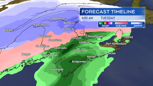
HALIFAX -- In a similar setup to late last week, a developing low-pressure system will move up and along an extended weather front from the west to bring a heavy mix of precipitation across the Maritimes
TIMING
This gets started Monday evening. Snow will develop across New Brunswick 8 p.m. to midnight. There will be a mix of snow and rain for P.E.I. near midnight, with Nova Scotia getting into rain before sunrise on Tuesday. The event extends all the way through Tuesday. P.E.I. and Nova Scotia will see heavy rain while a rain-snow line pushes north in New Brunswick. Northern and central New Brunswick will experience a mix of heavy snow, ice pellets, freezing rain, and rain.
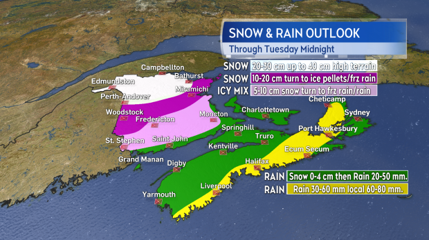
SNOW
As above, the most snow is expected in parts of northern and central New Brunswick. Along and north of a line from Perth-Andover to Bathurst amounts of 20 to 30 cm are forecast with some of the mountainous terrain picking up 30-40 cm. Just south of that line, snowfall amounts will be reduced to 10-20 cm, with a quicker turn to ice pellets and freezing rain. Much of the remainder of New Brunswick will see 5-10 cm of snow before a turn through an icy mix to rain. It is possible that P.E.I. and northern Nova Scotia start as some snow but the turn to rain for those areas should be quick enough to wash away any initial amounts.
FREEZING RAIN
An extended period of freezing rain is a risk through central New Brunswick. Areas from the Kennebecasis Valley west into Charlotte County and then north to Fredericton could experience 2 to 4 hours of freezing rain. In most cases, that will come on top of 5-10 cm of snow.
RAIN
Rain, heavy at times, is forecast for the Bay of Fundy coastline N.B., P.E.I., and Nova Scotia on Tuesday. Rainfall totals for many will range 20-40 mm. Along the Atlantic coastline of Nova Scotia and into the east, including Richmond and Inverness Counties, Cape Breton downpours may result in local amounts of 40-80 mm. Hydroplaning conditions on roads and localized flooding are a risk.
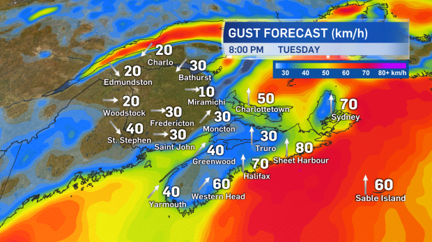
WIND
High and gusty southerly winds will develop for southeastern N.B., P.E.I., and Nova Scotia on Tuesday. Peak gusts will reach a range of 50 to 80 km/h, except over 110 km/h for northern Inverness, Cape Breton where a Wind Warning has been issued. Winds on Wednesday will turn west and reach gusts of 40 to 70 km/h. The westerly winds will drop temperatures Maritime-wide on Wednesday and the region will need to be cautious of icy surfaces and areas of lighter snow/flurries.
IMPACTS
The largest impact of this mix of weather will likely be travel conditions on roads. Wintry road conditions will develop for much of northern and central New Brunswick, made slippery in some cases by ice pellets and freezing rain. Heavy rain for P.E.I. and Nova Scotia will reduce visibility at times and water on the roads will reduce traction. Give yourself plenty of time and space on the roads Tuesday and consider avoiding/minimizing travel in adverse weather in your area.
A number of warnings, including winter storm, snowfall, and freezing rain, have been issued by Environment Canada. Please check the latest alerts in effect for your area here: https://weather.gc.ca/warnings/index_e.html


