
It’s been a steamy few days for the Maritimes with high temperatures away from the coast climbing into the high 20s and low 30s.
The hot and humid air is also fuel for thunderstorms. Rounds of showers and thunderstorms will progress across the region on Wednesday. The trigger for that unsettled weather is a cold front trailing from a centre of low pressure moving from northern Quebec into Labrador.
As the front, and associated showers, clears the Maritimes on Wednesday night, winds will turn northwest for Thursday. Those northwest winds will bring in some drier air and while temperatures are still warm for the Maritimes tomorrow, the humidity will be lower and should make for a more comfortable feel to the air for most.
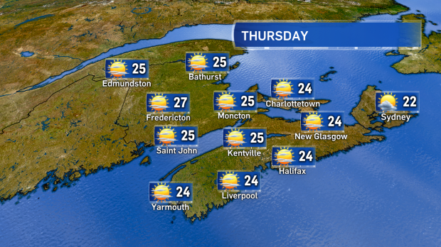
Mostly sunny and still warm tomorrow. A northwest winds will bring down humidity across the region.
Don’t plan on having the air conditioning or heat pump dialed down for long, though, as both temperature and humidity will rise through the end of the week and weekend.
A combination of a more northerly position in the jet stream and a core of hot air shifting east out of the Midwestern U.S. will bring us this next round of heat.
Saturday is expected to see highs hit the low 30s across much of New Brunswick and western areas of Nova Scotia with mid-to-high 20s for eastern Nova Scotia and P.E.I. When factoring in the humidex, most will feel into the mid-to-high 30s and some near 40. Similar temperatures are forecast for Sunday.
As a travel note, the core of this heat will be centred on the eastern seaboard of the U.S. this weekend. Boston is forecast to hit a high near 37 and New York City near 38 on Saturday with both areas feeling well into the 40s with humidity.

With the jet stream to the north and hot air in the US shifting east temperatures will soar in the Maritimes this weekend.
Looking for relief? Breezes off cooler ocean waters will keep temperatures moderated for coastal areas. For Saturday, the wind looks like it will be mostly onshore for coastal areas of Nova Scotia, the Bay of Fundy coastline in New Brunswick, and western coastal areas of Prince Edward Island. On Sunday, onshore winds will provide even more direct cooling for the Atlantic coastline of Nova Scotia -- including Cape Breton -- the Bay of Fundy coastline, the Acadian Peninsula of New Brunswick, and eastern Prince Edward Island.
Region wide, the heat and humidity will come down Monday into Tuesday of next week with a round of showers and turn to northwest winds.


