
HALIFAX -- A developing low-pressure system will move northward, just off the eastern U.S. seaboard on Saturday.
The low will reach a position just south of Nova Scotia by Saturday evening. After that time, there is considerable uncertainty on whether the system will move in close to the Atlantic coastline of Nova Scotia, or stay further to the east as it moves towards the south coast of Newfoundland Sunday morning.
A move closer to the coast would bring a more widespread heavy snowfall to Nova Scotia and eastern Prince Edward Island. A track further offshore reduces the risk of a heavy snow to all but eastern areas of Nova Scotia, including Cape Breton.
At this time it does look like it will be parts of Guysborough and Antigonish Counties and Cape Breton that have the greatest chance of seeing a snowfall in excess of 15 centimetres.
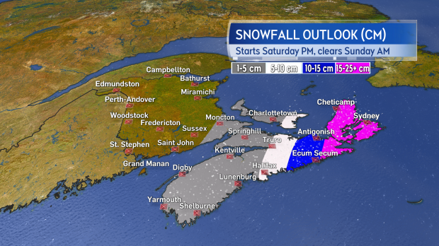
Currently the heaviest snow looks like it fall in eastern areas of NS. A shift westward with the system could bring that heavier snowfall further into that province as well as eastern PEI.
There is more certainty in the timing of the event. Snow will reach mainland Nova Scotia Saturday afternoon becoming widespread by evening. There may be some mixing in of ice pellets and rain on parts of the Atlantic coastline. Snow will reach P.E.I. and Cape Breton on Saturday evening and night, but clearing up by Sunday morning. Scattered flurries are likely for New Brunswick on Saturday afternoon through Sunday morning.
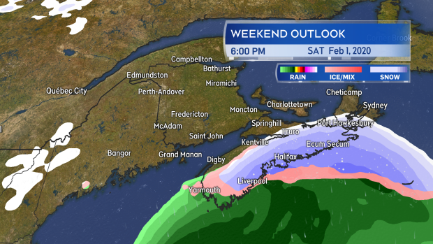
Snow arrives for mainland NS Saturday afternoon. It reaches PEI and Cape Breton during the evening and night before clearing through Sunday morning.
Unless the system comes in closer to Nova Scotia, winds look like they will remain below warning criteria. The strongest gusts are likely to occur Sunday afternoon and evening. They will mostly range between 30 to 60 km/h, but they could reach 60 to 80 km/h in Cape Breton. Gusty winds combined with a potentially heavy snowfall for eastern areas of Nova Scotia could produce areas of blowing and drifting snow.
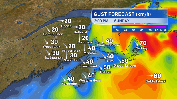
The gustiest winds will likely occur on Sunday in the wake of the passage of the low. Areas of drifting and blowing snow are likely for eastern areas of Nova Scotia.
Snowfall warnings have been issued for Guysborough and Antigonish Counties of mainland Nova Scotia and across Cape Breton. I would strongly recommend checking in on your forecast again on Saturday as the system has had a history of change in potential impacts.
Takeaways
- System arrives Saturday afternoon through Sunday morning.
- Currently eastern Nova Scotia is most likely to see heavy snow. Snowfall warnings issued.
- There remains uncertainty in that forecast. Check your forecast ad alerts again Saturday.
- Gusty winds Saturday night and Sunday may produce areas of blowing and drifting snow.


