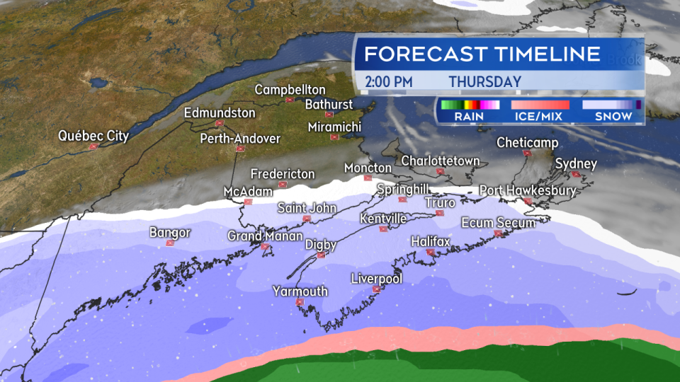
HALIFAX -- A developing low-pressure system moving up the U.S. eastern seaboard will track east of Cape Cod and hold just south of Nova Scotia on Thursday.
That track is a great setup for snow in the province as it gets close enough to wrap moisture into the very cold air that has moved into place over the past 36 hours.
Snow should begin early Thursday morning for the tri-counties (Digby/Yarmouth/Shelburne) of Nova Scotia. Southwestern New Brunswick will see some some light snow, except for Grand Manan, where it will turn heavier. By near noon the snow will have moved up the Annapolis Valley and South Shore into the Halifax area. Eastern and northern Nova Scotia and Cape Breton will see the snow move in Thursday afternoon through the early evening.
Southern New Brunswick and Prince Edward Island will be on the edge of the system with mainly a lighter snow or flurries expected. Much of Cape Breton may only see a lighter snow as well.
Snow, heavy for some areas, will persist in Nova Scotia Thursday evening and night before breaking down to areas of lighter snow and flurries Friday morning.
Snow will develop Thursday morning through the afternoon. Some of the heaviest snow looks like it will fall Thursday evening.
AMOUNTS
The most snow is expected in the Halifax area and in western Nova Scotia. Widespread totals of 10 to 25 cm look likely by Friday morning through that area. A band of higher amounts, 25 to 35 cm, could be present in a line from Digby County into Queens and Lunenburg counties. Some mixing in of ice pellets looks likely for coastal areas of Yarmouth and Shelburne counties.
Northern and eastern areas of Nova Scotia will likely see the snow taper lower to a range of 5 to 10 cm or possibly even less. Southern areas of New Brunswick as well as P.E.I. could pick up amounts of trace to 5 cm in lighter snow and flurries. Very little, if any, snow is expected in northern and central New Brunswick.
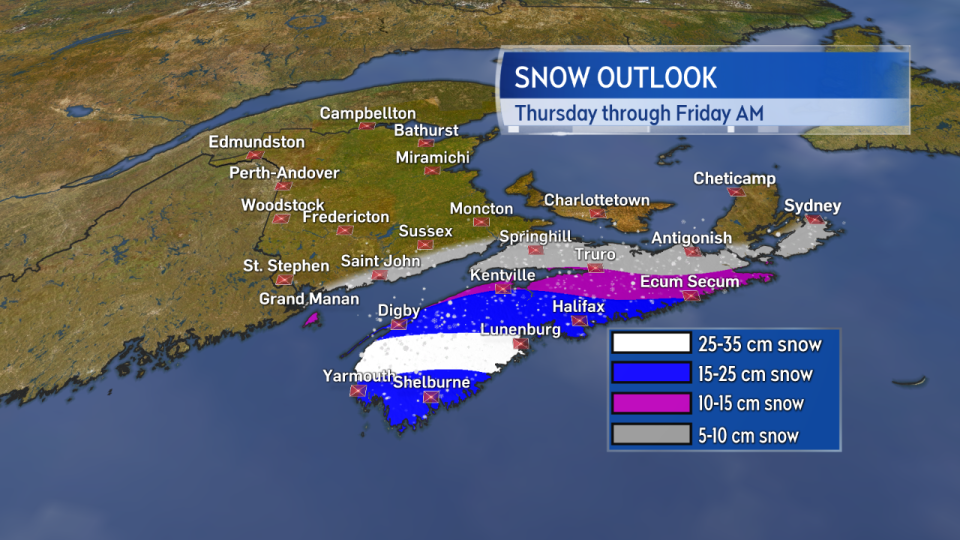
The most widespread snow in excess of 15 cm looks most likely in the Halifax area and in western Nova Scotia.
WIND
A northeast wind will steadily increase through the day Thursday. By evening, widespread gusts of 30 to 60 km/h are forecast. That is high enough to blow the snow around as it falls. This could create periods of near whiteout conditions during the heaviest snow. Western areas of Nova Scotia should expect those conditions to be most widespread late Thursday afternoon, evening, and night.
The wind turns north for Friday, but will still be gusting 20 to 50 km/h. Areas of drifting snow will be possible for Nova Scotia.
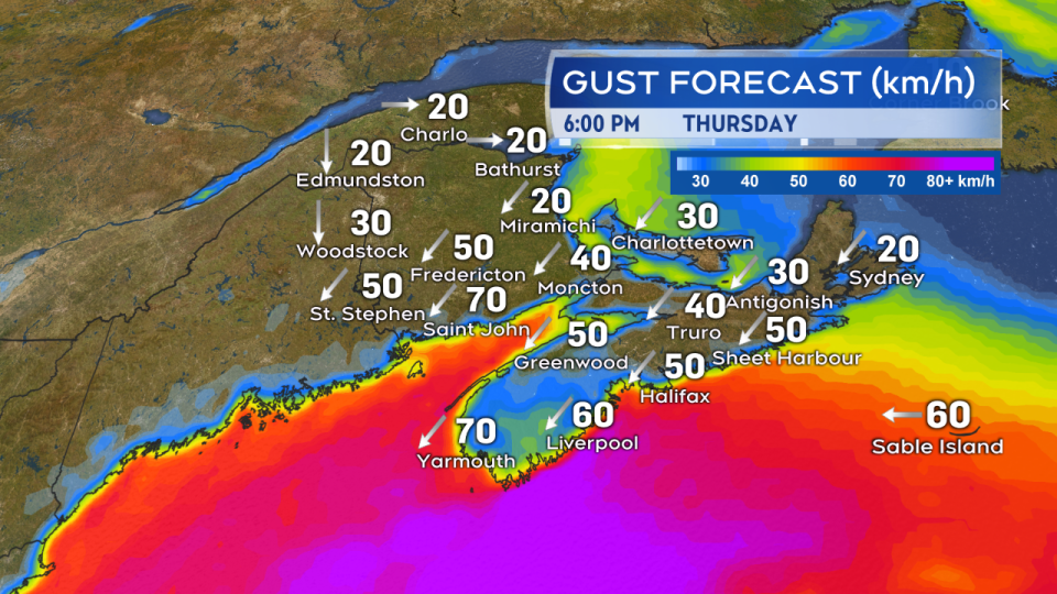
Northeast winds will increase to hit widespread gusts of 30 to 60 km/h Thursday evening -- enough to get the falling snow blowing around.
MARINE
No coastal flooding is expected.
Returning gale force winds of 34-plus knots are likely for the Bay of Fundy and southern and eastern Atlantic Canada marine districts Thursday afternoon, evening, and night. Seas may build three to six metres for some areas. Marine interests should review a more detailed marine forecast.
ALERTS
Snowfall warnings were issued by Environment Canada Wednesday afternoon for Halifax County, the South Shore, Tri-Counties, and Annapolis County. Surrounding areas remain under a Special Weather Statement cautioning of accumulating snow on Thursday. There is still time for change in the forecast for the system, so it is worth checking in on any alerts active for your area again on Thursday.


