Kalin's Call: Another icy mix expected for the Maritimes Thursday night and Friday
A similar weather system to the one last weekend will move into the Maritimes Thursday night and Friday.
The system is a coastal low that will move up from the northeastern United States. The developing low branching off from a system, moving from the United States Midwest into Ontario.
That is the same system responsible for a tornado outbreak in the southern United States Monday and Tuesday.
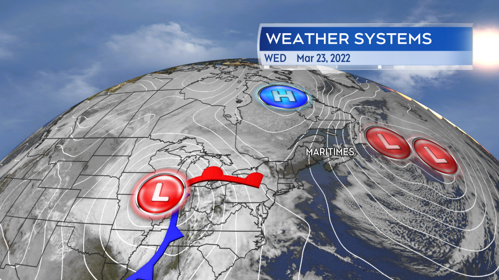 The late week icy weather will be a result of a secondary low developing off the system currently positioned in the United States Midwest.
The inclement weather will start Thursday evening, with snow arriving in western New Brunswick and southwestern Nova Scotia.
Through the overnight, snow will mix with, or turn into, ice pellets and freezing rain will develop across the region.
The icy weather will be most persistent for northern and eastern areas of the Maritimes on Friday. Western Nova Scotia and southwestern New Brunswick will have a faster transition to rain. The mix of precipitation will clear the Maritimes Friday afternoon and evening, west-to-east.
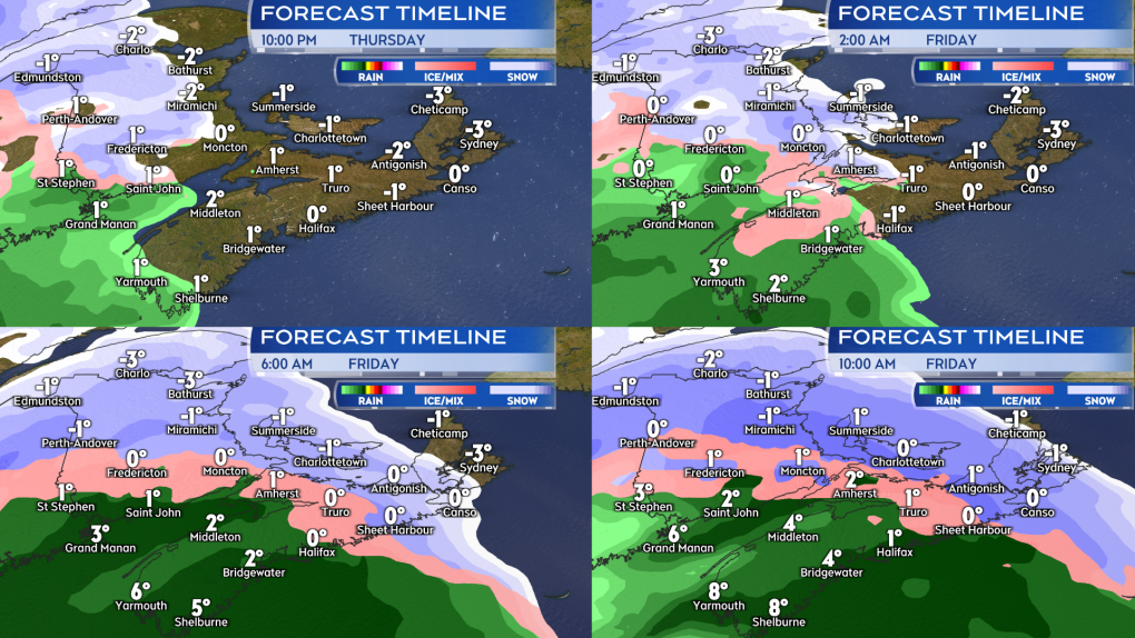 A mix of snow, ice pellets, freezing rain, and rain develops across the region Thursday night into Friday morning.
Northern areas of New Brunswick can expect some snow and ice pellet accumulation of 10 to 20 cm.
Much of the remainder of New Brunswick, Prince Edward Island, as well as northern and eastern areas of Nova Scotia, have a risk of a prolonged period of freezing rain Friday morning. Cape Breton could see some freezing rain linger into Friday afternoon.
Ice collection from freezing rain can cause some power outages. Areas that see mostly rain, including near the Bay of Fundy coastline in New Brunswick and western Nova Scotia, can expect general totals of 20 to 40 mm.
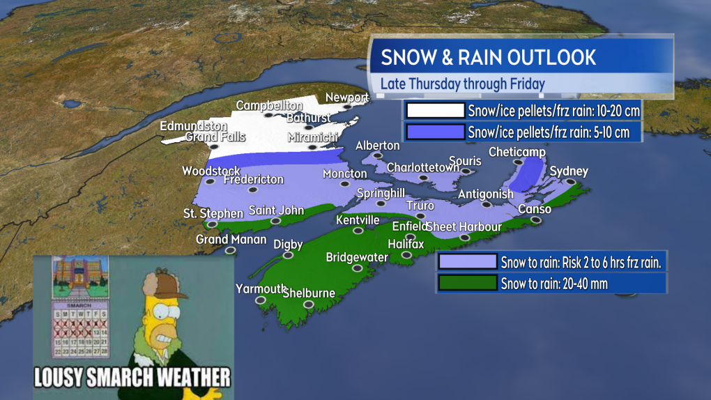 Snow and ice pellets may accumulate to more than 10 cm in northern areas of New Brunswick. Much of N.B., P.E.I., and northern/eastern Nova Scotia have a risk of an extended period of freezing rain.
The wind will pick up a bit on Friday, with east and southeast gusts peaking 30 to 60 km/h for much of the region. Gusts will peak near 90 km/h for northern Inverness County due to the topography of the Cape Breton Highlands.
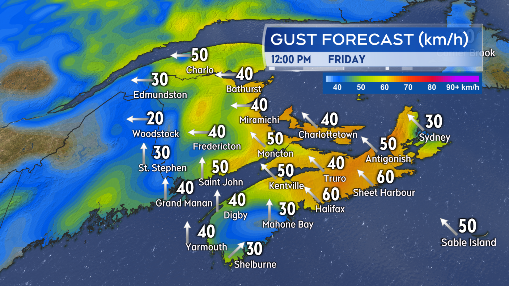 Gusty east and southeast winds will accompany the mix of precipitation on Friday. Peaking 30 to 60 km/h, except up to 90 km/h for northern Inverness County, N.S.
Special weather statements are in effect for parts of all three Maritimes provinces. Environment Canada is advising the public to monitor the forecast and any further alerts issued.
I will have updates on CTV Atlantic News at Noon, 5, 6, and 11:30 p.m.


CTVNews.ca Top Stories
Humboldt Broncos crash victims and families react to decision to deport truck driver
The family of one of the victims of the Humboldt Broncos bus crash in 2018 says they are 'thankful' for a decision by a Calgary immigration board to deport the driver of the truck involved.
A woman took her dog to a shelter to be euthanized. A year later, the dog is up for adoption again
Exhausted and short on options after consulting two veterinary clinics, Kristie Pereira made the gut-wrenching decision last year to take her desperately ill puppy to a Maryland shelter to be euthanized.
Toddler dies after being struck by recycling truck in Barrie, Ont. neighbourhood
A toddler has died after being struck by a recycling truck in a Barrie, Ont. neighbourhood on Thursday afternoon.
Community mourns victims of fatal boat crash near Kingston, Ont.
The three people killed in last weekend's tragic collision between a speedboat and a fishing boat north of Kingston are being remembered Friday.
'God forgives but we don’t': Loud outburst from stabbing victim’s family during sentencing hearing
An emotional outburst in a London, Ont. courtroom Friday disrupted the sentencing hearing of a woman who pleaded guilty for her part in the death of a 29-year-old Mohammed Abdallah.
Governments must disaster-proof Canada's hospitals against climate change: experts
Last month, the Canadian Medical Association warned that Canada's health-care facilities are among the oldest public infrastructure in use. Half were built more than 50 years ago, making them especially vulnerable to extreme climate events.
Luciano Benetton says he's stepping down as chairman of family-run brand as losses top US$100 million
Luciano Benetton, a co-founder of the apparel brand, announced he was stepping down as chairman in an interview published on Saturday with Milan daily Corriere della Sera. He blamed current management for losses of 100 million euros (US$108.5 million) that he discovered last year.
1 dead, 3 in hospital after flying wheel crashes into bus windshield on QEW
A man is dead, and three others are in hospital after a flying wheel crashed into a coach bus on the QEW in St. Catharines.
NASA launches tiny CubeSat to set its sights on Earth
NASA has launched the first of two research satellites to measure how much heat is lost to space from the Arctic and Antarctica.
Shopping Trends
The Shopping Trends team is independent of the journalists at CTV News. We may earn a commission when you use our links to shop. Read about us.


Toronto
-

Are you a loud snorer? You could have sleep apnea
You'll have a lot more energy throughout the day if you get a good night's sleep, but not everyone does due to a medical condition.
-
1 dead, 3 in hospital after flying wheel crashes into bus windshield on QEW
A man is dead, and three others are in hospital after a flying wheel crashed into a coach bus on the QEW in St. Catharines.
-
Teen stabbed near shopping centre in Mississauga: police
A teen was taken to hospital with serious injuries after being stabbed by another teen Friday night in Mississauga.
Calgary
-
Calgary newcomers find community garden, learn Indigenous ways at Land of Dreams farm
A unique farm in southeast Calgary that offers newcomers a chance to connect with, and learn from, Indigenous communities, launches its growing season Saturday morning.
-
Calgarian named Paramedic of the Year
A Calgary paramedic has received national recognition for his years of work on the frontline, and spearheading research to improve patient outcomes.
-
MRU prof calls out institution for lack of action against anti-Semitism on campus
Months after a troubling encounter on the Mount Royal University campus, which ended in a criminal charge against a protester, a professor is calling out the institution for not doing more to provide a safe environment for Jewish faculty and students.
Edmonton
-
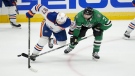
Five things to know about the NHL playoffs
The Florida Panthers got close but fell short of going up 2-0 in their series on Friday, something the Edmonton Oilers look to do Saturday night.
-
Edmonton teen murder victim was fatally stabbed, autopsy shows
A 15-year-old boy who was killed in Edmonton earlier this week was fatally stabbed, an autopsy has confirmed, and his death has been deemed a homicide.
-
Zelenskyy says Ukraine has taken back control in areas of the embattled Kharkiv region
Ukrainian forces have secured "combat control" of areas where Russian troops entered the northeastern Kharkiv region earlier this month, Ukrainian President Volodymyr Zelenskyy said.
Montreal
-

Legault calls social media platforms 'virtual pushers' as party mulls age restrictions
Social media platforms are nothing less than 'virtual pushers,' according to Premier François Legault.
-
Private property or public space? Encampments spark debate over campus status
After four weeks that have featured torrential downpours, blistering heat and two failed legal bids to have them removed, pro-Palestinian protesters remain encamped on McGill University’s downtown campus.
-
Quebec Liberal convention: party commits to balanced budget if it takes power
History will recognize the benefits of the Philippe Couillard government, according to the Quebec Liberal Party (PLQ), which is committed to returning to a balanced budget if it takes power.
Ottawa
-
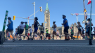
Here's what you need to know about Ottawa Race Weekend this weekend
Thousands of runners will lace up their sneakers this weekend for the Tamarack Ottawa Race Weekend. Here is everything you need to know about Tamarack Ottawa Race Weekend, including road closures.
-
Community mourns victims of fatal boat crash near Kingston, Ont.
The three people killed in last weekend's tragic collision between a speedboat and a fishing boat north of Kingston are being remembered Friday.
-
Here are some tips to deal with spring allergies
Though it’s undeniable how beautiful spring flowers can be, allergies remain a major concern for many people, says an Ottawa pharmacist.
London
-

City councillor withdraws proposed curfew for gas powered lawn equipment after negative feedback
Several days after a motion was first put forward that would have limited the time of day when Londoners could use gas powered lawn equipment, the city councillor who proposed it is speaking out.
-
Londoners get soaked at 'Touch a Truck' event
On a rain-soaked Saturday morning, families with excited children filled the Earl Nichols Recreation Centre parking lot to learn all about trucks.
-
'We bring grit and heart': Powerful Knights get stronger with return of 2 veterans
Kaleb Lawrence has only played once in the London Knights last 11 games. After serving a pair of five-game suspensions for checking to the head and neck, he is ready to return Saturday afternoon in the first game of the Memorial Cup tournament against Drummondville.
Barrie
-

Annual memorial golf tournament honours Chase McEachern's legacy
The legacy of a young boy's passionate campaign to install defibrillators in schools and arenas to save lives continues to inspire people across the province.
-
Toddler dies after being struck by recycling truck in Barrie, Ont. neighbourhood
A toddler has died after being struck by a recycling truck in a Barrie, Ont. neighbourhood on Thursday afternoon.
-
Barrie residents join March to End Homelessness
In response to the worsening housing and homelessness crisis in communities across the province, a provincial day of action took place on Saturday.
Northern Ontario
-
Suspect sought in suspicious death in northern Ont.
Ontario Provincial Police in Cochrane are asking for the public’s help in locating a man they want to speak with in connection with a suspicious death.
-
Police clear scene near Highways 11 & 654
Provincial police say they have concluded their investigation in Callander, Ont., south of North Bay, after asking residents to avoid the area of Highway 11 and Highway 654 on Saturday morning.
-
Out-of-control fire rages southeast of Cobalt, Ont.
A now 134-hectare fire is burning three kilometres southeast of Cobalt near the east shore of Kerr Lake, the province’s Aviation, Forest Fire and Emergency Services says.
Kitchener
-

Purolator truck drivers from Guelph, Ont. save man walking in Hwy. 407 lanes
A pair of Purolator transport truck drivers from Guelph, Ont. are being hailed as heroes for their efforts in helping a person in crisis.
-
Waterloo unveils fully accessible, self-cleaning washroom
A new public washroom has opened in Uptown Waterloo and not only can it self-clean, but it's all fully accessible.
-
Five people taken to hospital and 26 displaced after Cambridge fire
Five people were taken to hospital, and more than two dozen forced from their homes, after flames tore through a Cambridge apartment building on Thursday night.
Windsor
-
 ICYMI
ICYMIICYMI CTV News Windsor's top stories from this week
In case you missed it, CTV News Windsor has compiled all the top local stories from this week into one video for your convenience.
-
Bodies recovered in search off Sandpoint Beach
Windsor police report the bodies of two young men swept underwater by the current near Sandpoint Beach on Thursday have been recovered.
-
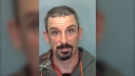
Erie Street shooting suspect arrested while attempting to board plane: Windsor police
A 23-year-old man who allegedly shot at a vehicle during a dispute on Erie Street East earlier this week was arrested Friday while attempting to board a flight out of the country, according to Windsor police.
Winnipeg
-
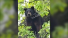
‘It’s pretty alarming’: Urban Wildlife encounters in Winnipeg this week
When you consider what kind of animals you might encounter in your Winnipeg neighborhood, a bear probably isn’t on your list.
-
School division says Grade 12 exam suspended
Some Grade 12 students will not be writing their ELA exams Monday.
-
Rain, snow hit parts of southern Manitoba as system moves north from the U.S.
Parts of southern Manitoba have been hit by a lot of rain, and even snow, as a low-pressure system moves in from the United States.
Regina
-

Sask. first responders speak out following social media posts of accident scene
Yorkton Protective Fire Services is asking the public to have some compassion when taking photos and videos during the aftermath of accidents.
-
Human remains found in Canora, Sask.
An investigation us underway after RCMP say human remains were found in the town of Canora about 50 kilometres north of Yorkton.
-
Humboldt Broncos crash victims and families react to decision to deport truck driver
The family of one of the victims of the Humboldt Broncos bus crash in 2018 says they are 'thankful' for a decision by a Calgary immigration board to deport the driver of the truck involved.
Saskatoon
-

Sask. swimmer qualifies for 2024 Olympic Games, sets Canadian record
A swimmer from Saskatoon has qualified for the 2024 Olympic Summer Games in Paris.
-
Humboldt Broncos crash victims and families react to decision to deport truck driver
The family of one of the victims of the Humboldt Broncos bus crash in 2018 says they are 'thankful' for a decision by a Calgary immigration board to deport the driver of the truck involved.
-
Saskatoon police investigating after two people stabbed on city bus
Saskatoon police are investigating after a 20-year-old man and a 15-year-old girl were stabbed on a city bus Thursday night.
Vancouver
-

No merger: BC Conservatives rejected non-competition deal, BC United says
BC Conservatives have rejected a non-competition deal proposed by BC United, the party formerly known as the BC Liberals says, putting an end to talks about a possible merge between the two parties.
-
Governments must disaster-proof Canada's hospitals against climate change: experts
Last month, the Canadian Medical Association warned that Canada's health-care facilities are among the oldest public infrastructure in use. Half were built more than 50 years ago, making them especially vulnerable to extreme climate events.
-
Whitecaps fans frustrated superstar Messi will miss Vancouver vs. Miami game
Marc DeLuca and his wife had the perfect sixth birthday gift for their son, Jack — tickets to see Lionel Messi and Inter Miami CF play the Whitecaps in Vancouver.
Vancouver Island
-
No merger: BC Conservatives rejected non-competition deal, BC United says
BC Conservatives have rejected a non-competition deal proposed by BC United, the party formerly known as the BC Liberals says, putting an end to talks about a possible merge between the two parties.
-
Governments must disaster-proof Canada's hospitals against climate change: experts
Last month, the Canadian Medical Association warned that Canada's health-care facilities are among the oldest public infrastructure in use. Half were built more than 50 years ago, making them especially vulnerable to extreme climate events.
-
RCMP officer's social media posts prompt calls for suspension from First Nation chief
A British Columbia First Nation is calling for the suspension and removal of an RCMP officer from Bella Bella over social media posts he made before joining the Mounties.
Kelowna
-
'Altercation' in Penticton leaves 1 dead: RCMP
One person is dead after a fight in Penticton early Sunday morning, according to authorities.
-
Suspect fled in 2-door Fiat after convenience store robbery, Merritt RCMP say
A suspect is at large after robbing a convenience store at gunpoint in Merritt, B.C., Friday, according to local police.
-
Kamloops RCMP issue public warning about 2 men allegedly at centre of 'organized crime conflict'
After four targeted shootings in four days, Mounties in Kamloops are taking the unusual step of warning the public about two men they believe are likely to be targeted in future violent incidents.


