Weather warnings issued in Maritimes for strong wind, heavy rain Wednesday into Thursday
 Hikers walk along Lawrencetown Beach Provincial Park in , Lawrencetown, N.S. as waves and heavy winds battered the coastline on Sunday, January 14, 2024. (Source: THE CANADIAN PRESS/Darren Calabrese)
A low-pressure system moving through the Great Lakes area will strengthen along the boundary of unseasonably warm air in place in the Midwestern U.S./southern Ontario and frigid air in place across Hudson Bay and northern Quebec. The storm will take a path northward through western Quebec Wednesday into Thursday. The Maritime provinces will be squeezed between that storm and an area of higher pressure to our northeast. That squeeze will drive a strong southerly wind and bring rain, heavy for some areas, to our region late Wednesday into early Thursday.
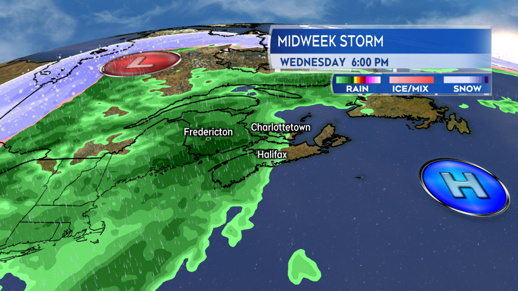 Squeezed between the strong low in Quebec and high pressure to our east the Maritimes will get into a round of rain and strong wind Wednesday into Thursday. (Source: CTV News Atlantic)
Heavy rain
The first of the wet weather arrives as early as late Tuesday night into Wednesday morning. Patchy showers or drizzle developing in western areas of New Brunswick and southwestern areas of Nova Scotia. A moderate rain moves into western New Brunswick and southwestern Nova Scotia during the day Wednesday. There will be a chance of showers for the remainder of the Maritimes.
Rounds of heavier rain then arrive Wednesday night for central/southern New Brunswick as well as western Nova Scotia. The rain is not expected to fall as heavily for northern New Brunswick, Prince Edward Island, and eastern Nova Scotia. The rain will continue for most areas into early Thursday morning. The rain may switch back to a brief period of snow before clearing the Maritimes west-to-east Thursday morning into Thursday afternoon.
Rainfall amount could generally range 30-to-60 mm in central/southern New Brunswick and western Nova Scotia. There will be higher rain amounts of 60-to-100 mm near the Bay of Fundy coastline in New Brunswick. That is a heavy winter rain. When combined with the frozen ground, snow/ice melt, and the chance that some drainage systems may be blocked by winter debris, it increases the risk of localized flooding.
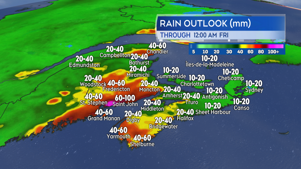 Some of the higher rain totals through Thursday are expected in central/southern New Brunswick and western Nova Scotia. (Source: CTV News Atlantic)
Strong wind
As above, the squeeze between the strong low and high pressure to our northeast drives a high and gusty southerly wind. Wind gusts reaching 90 km/h will arrive for southern New Brunswick and western Nova Scotia by Wednesday evening. The strong winds will then moving to eastern Nova Scotia and Prince Edward Island by early Thursday morning. Due to the topography of the Cape Breton Highlands, there is a risk peak gusts for northern Inverness County could reach 120 km/h Thursday morning.
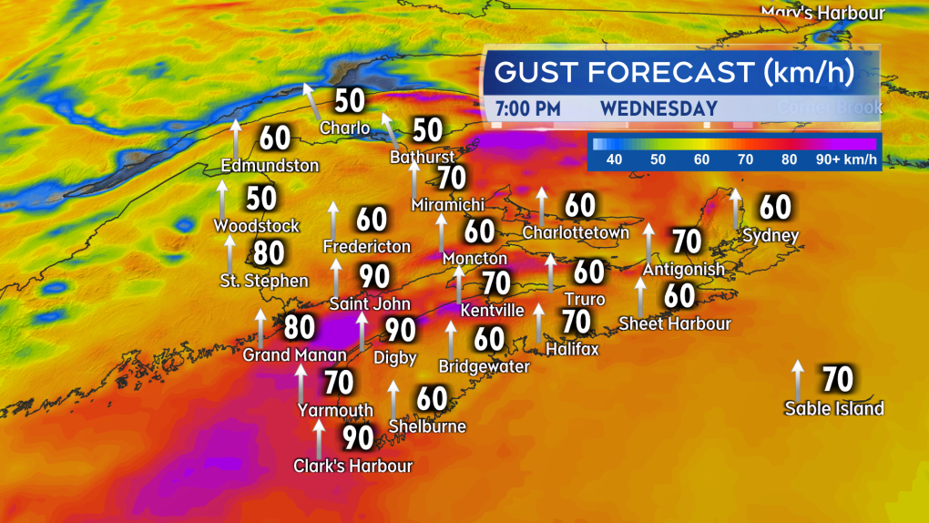 A southerly wind with peak gusts nearing 90 km/h reaches southern New Brunswick and western Nova Scotia Wednesday evening. (Source: CTV News Atlantic)
By Thursday afternoon the wind will become northwest with peak gusts in the range of 40-to-70 km/h. While not as strong, the northwest wind will usher colder air back into the region with temperatures falling back to and below freezing across the Maritimes by Thursday afternoon. While not quite matching as quick a plunge as this past weekend, caution should be taken about any untreated wet surfaces turning icy by Thursday evening.
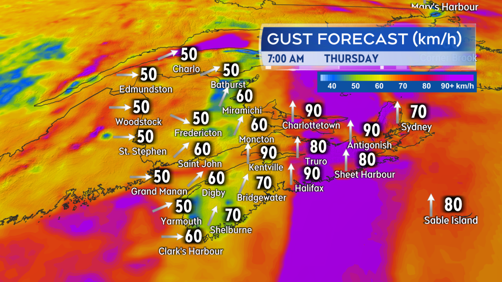 The strong southerly wind shifts to eastern Nova Scotia and Prince Edward Island by very early Thursday morning. The entire Maritimes over to a cold, gusty northwest wind by Thursday afternoon. (Source: CTV News Atlantic)
Weather alerts
Environment Canada has issued rainfall warnings for western New Brunswick and southwestern Nova Scotia, where the rain is expected to reach first and become heavy at times. The warnings call for rain totals of 25-to 60-mm except 60-to-90+ mm in southern New Brunswick. The rain will fall Wednesday morning through Thursday afternoon.
Wind warnings are now in effect for southern New Brunswick and the Tri-county area of Nova Scotia. The warning calls for a southerly wind gusting 70-to-100 km/h Wednesday evening until Thursday morning.
Special weather statements extend into eastern New Brunswick and across the remainder of mainland Nova Scotia. The statement calls for possible areas of 25-to-60 mm of rain and gusts that could reach 70-to-90 km/h Wednesday night into Thursday. These areas are little later to get into the rain and wind compared to the warned areas to the west. It is possible that they are added to the weather warnings as the system approaches.
I’ll have updates, timelines, and regional weather conditions on CTV News Atlantic programming 5 p.m., 6 p.m., and 11:30 p.m.
Shopping Trends
The Shopping Trends team is independent of the journalists at CTV News. We may earn a commission when you use our links to shop. Read about us.


CTVNews.ca Top Stories

Bird flu, measles top 2025 concerns for Canada's chief public health officer
As we enter 2025, Dr. Theresa Tam has her eye on H5N1 bird flu, an emerging virus that had its first human case in Canada this year.
DEVELOPING
DEVELOPING Body found in wheel well of plane at Maui airport
A person was found dead in the wheel well of a United Airlines flight to Maui on Tuesday.
Raised in Sask. after his family fled Hungary, this man spent decades spying on communists for the RCMP
As a Communist Party member in Calgary in the early 1940s, Frank Hadesbeck performed clerical work at the party office, printed leaflets and sold books.
Ottawa police identify victim of Christmas Day homicide in Hintonburg, charge suspect
The Ottawa Police Service says the victim who has been killed on Christmas Day in Hintonburg has been identified.
Christmas shooting at Phoenix airport leaves 3 people wounded
Police are investigating a Christmas shooting at Sky Harbor Airport in Phoenix that left three people injured by gunfire.
Ship remains stalled on St-Lawrence River north of Montreal
A ship that lost power on the St. Lawrence River on Christmas Eve, remains stationary north of Montreal.
Your kid is spending too much time on their phone. Here's what to do about it
Wondering what your teen is up to when you're not around? They are likely on YouTube, TikTok, Instagram or Snapchat, according to a new report.
Bird flu kills more than half the big cats at a Washington sanctuary
Bird flu has been on the rise in Washington state and one sanctuary was hit hard: 20 big cats – more than half of the facility’s population – died over the course of weeks.
6,000 inmates stage Christmas Day escape from high-security Mozambique prison
At least 6,000 inmates escaped from a high-security prison in Mozambique's capital on Christmas Day after a rebellion, the country's police chief said, as widespread post-election riots and violence continue to engulf the country.
Toronto
-

Boxing Day bargain hunters hit GTA stores in search of deals
Deal hunters are hitting stores around the GTA today to try take advantage of Boxing Day bargains and a tax holiday that offers further discounts.
-
Man wanted for 2 unprovoked incidents in downtown Toronto on Christmas Eve
Toronto police are searching for a suspect who allegedly choked a female in downtown Toronto then threatened an employee at a business with a hammer.
-
1 person seriously injured in Scarborough stabbing
One person was taken to the hospital with serious, but non-life-threatening injuries following a stabbing on Dec. 25 in Scarborough, say paramedics.
Calgary
-

Naheed Nenshi finding his feet leading an Alberta NDP still under construction
Nenshi finding his feet leading an Alberta NDP still under construction
-
Bird flu, measles top 2025 concerns for Canada's chief public health officer
As we enter 2025, Dr. Theresa Tam has her eye on H5N1 bird flu, an emerging virus that had its first human case in Canada this year.
-
Solar burgers: How agrivoltaics is marrying food production with green energy
Jason Bradley spent 20 years of his career as ranch manager at a 50,000-acre grazing operation in west-central Alberta, so he understands why people react with skepticism to the idea of raising a herd of cattle on a working solar farm.
Edmonton
-

Alberta premier hopes for health reform payoff in 2025, regrets deferring tax cut
"It may have been better for Albertans if we'd implemented and then found a way to be able to pay for it."
-
Naheed Nenshi finding his feet leading an Alberta NDP still under construction
Nenshi finding his feet leading an Alberta NDP still under construction
-
Donald Trump says he urged Wayne Gretzky to run for prime minister in Christmas visit
U.S. president-elect Donald Trump says he told Canadian hockey legend Wayne Gretzky he should run for prime minister during a Christmas visit but adds that the athlete declined interest in politics.
Montreal
-
 WEATHER
WEATHER Smog warning in effect in Montreal, Laval
Residents of Montreal, Laval and other regions are advised that a smog warning is in effect.
-
Teen cancer patient pays forward Make-A-Wish donation to local fire department
A 16-year-old cancer patient from Hemmingford, Que. decided to donate his Make-A-Wish Foundation gift to the local fire department rather than use it himself.
-
Ship remains stalled on St-Lawrence River north of Montreal
A ship that lost power on the St. Lawrence River on Christmas Eve, remains stationary north of Montreal.
Ottawa
-

Ottawa police identify victim of Christmas Day homicide in Hintonburg, charge suspect
The Ottawa Police Service says the victim who has been killed on Christmas Day in Hintonburg has been identified.
-
Ottawa G1 driver caught driving uninsured, unaccompanied with out-of-service plate on HWY 417
A G1 driver is facing multiple charges after being stopped on Highway 417 in Ottawa for out-of-service licence plate Wednesday, according to the Ontario Provincial Police (OPP).
-
It feels like minus 13 with the windchill this Boxing Day in Ottawa
Attention Ottawa shoppers! It’s cold outside, as it feels like minus 13 with the windchill this Boxing Day.
London
-

Palace Theatre boarded up over the holidays due to recent damage
A break in, theft, and continued property damage has led to the boarding up of the Palace Theatre over the Christmas holidays.
-
Knights stars ready to help Canada chase gold at World Juniors
Three London Knights are on the roster, including Easton Cowan, who scored a hat-trick in Canada’s first exhibition game.
-
London fire responds to Wellington Road collision, contains fuel leak
London Fire Department was on the scene of a two vehicle collision involving a delivery truck on Tuesday morning.
Barrie
-

Health board reminds of resources for holiday grieving
The Board of Health of Grey Bruce Public Health is reminding those who are experiencing grief, loss, isolation or other challenges during the holiday season that there are helpful resources and supports available.
-
Last minute shoppers braced for chaos but found calm on Christmas Eve
Many shoppers were out on Christmas Eve, and while the rush was expected to be chaotic, many found the day surprisingly manageable.
-
Help this missing pup make it home for Christmas
The Ontario SPCA in Barrie needs your help bringing this handsome pup home to his family before Christmas.
Northern Ontario
-
Bird flu, measles top 2025 concerns for Canada's chief public health officer
As we enter 2025, Dr. Theresa Tam has her eye on H5N1 bird flu, an emerging virus that had its first human case in Canada this year.
-
Indigenous family faced discrimination in North Bay, Ont., when they were kicked off transit bus
Ontario's Human Rights Tribunal has awarded members of an Indigenous family in North Bay $15,000 each after it ruled they were victims of discrimination.
-
Swimmer Summer McIntosh voted The Canadian Press female athlete of the year for 2024
During the month before her 18th birthday, Summer McIntosh became the first Canadian to win three gold medals in a single Olympic Games, winter or summer, with a silver medal thrown in for good measure.
Kitchener
-

Marking the start of Hanukkah in Guelph and Waterloo Region
People across Guelph and Waterloo Region are celebrating the start of Hanukkah.
-
Baden-born player, Guelph Storm forward and former Kitchener Ranger prepare to hit the ice at World Juniors
Waterloo Region and Guelph will be well represented as the International Ice Hockey Federation World Juniors gets underway.
-
Boxing Day bargain hunters hit GTA stores in search of deals
Deal hunters are hitting stores around the GTA today to try take advantage of Boxing Day bargains and a tax holiday that offers further discounts.
Windsor
-

Mother-daughter duo pursuing university dreams at the same time
For one University of Windsor student, what is typically a chance to gain independence from her parents has become a chance to spend more time with her biggest cheerleader — her mom.
-
VIDEO
VIDEO From a repaired stuffed animal to an ATV, shoppers reveal the best gift they have ever received
We asked people of all ages getting in some last-minute Christmas Eve shopping inside Windsor’s Devonshire Mall to talk about the best present they've ever received — and their answers might just warm your heart this holiday season.
-
'We may have to look at other sensible locations': Where will Windsor’s new H4 be located?
The search for a site to house Windsor’s new Homelessness and Housing Help Hub (H4) is back underway after the city scrapped plans at 700 Wellington Avenue on Monday.
Winnipeg
-

'They gambled with trees': Cutting down trees resumes in Lemay Forest
The next chapter of the Lemay Forest saga has unfolded as the sounds of trees coming down could be heard Monday.
-
One person dead, another injured following Monday night house fire
One person has died and another is in unstable condition following a house fire Monday evening.
-
Winnipeg police investigating string of packages being stolen
The Winnipeg Police Service is investigating a string of package thefts in the Transcona area.
Regina
-

Pedestrian collision sends man to hospital with life-threatening injuries
One man has been sent to hospital with life-threatening injuries after he was struck by a vehicle in the early hours of Wednesday in Regina.
-
Here's what's open and what's closed in Regina this holiday season
Here's what residents can expect in terms of city services as Regina slides right into the Christmas holidays.
-
Raised in Sask. after his family fled Hungary, this man spent decades spying on communists for the RCMP
As a Communist Party member in Calgary in the early 1940s, Frank Hadesbeck performed clerical work at the party office, printed leaflets and sold books.
Saskatoon
-
Raised in Sask. after his family fled Hungary, this man spent decades spying on communists for the RCMP
As a Communist Party member in Calgary in the early 1940s, Frank Hadesbeck performed clerical work at the party office, printed leaflets and sold books.
-
IN PICTURES: CTV Saskatoon viewers send us their holiday photos
A living gallery of viewer-submitted photos from the holiday season. Share your pictures with us at SaskatoonNews@bellmedia.ca
-
Sask. highway closed following serious collision
The Saskatchewan RCMP are investigating a serious collision on Highway 7, approximately 15 kilometres west of Rosetown.
Vancouver
-

Multiple sailing waits for BC Ferries after further cancellations
BC Ferries cancelled multiple early morning sailings between the Lower Mainland and Vancouver Island Thursday morning, as weather warnings due to wind and heavy rain remain in effect.
-
Passenger dead following pickup truck crash in Surrey, B.C.
A section of B.C.’s Highway 15 has closed following a crash that killed a person Christmas Day.
-
Homegrown gift-giving initiative makes Christmas morning magic for families in need
On Christmas morning, hundreds of families throughout the Lower Mainland who otherwise might not have had anything to open were given sackfuls of brightly wrapped gifts to unwrap with their families, courtesy of a grassroots charity ran by one Surrey woman.
Vancouver Island
-

BC Ferries cancels many Christmas Day sailings, says others 'at risk'
The stormy weather in the forecast for B.C.'s South Coast is already disrupting many Christmas Day travel plans.
-
Janitors at Vancouver airport ratify deal with employer, end strike
The janitors who clean the Vancouver International Airport have ratified a new collective agreement with their employer, ending their strike on Christmas Eve.
-
Gas leaking after truck crash in Port Moody not ammonia, police say
There were tense moments for first responders in Port Moody on Christmas Eve, after a commercial truck crashed and began leaking gas.
Kelowna
-

Forfeited Hells Angels clubhouse in Kelowna, B.C., sold to the city
A former Hells Angels clubhouse that was seized by the British Columbia government in 2023 after years of fighting in court has been sold to the City of Kelowna.
-
Death of woman found in Kelowna's Waterfront Park in June deemed 'non-criminal in nature': RCMP
Police in Kelowna say a death they began investigating back in June has now been confirmed as "non-criminal in nature."
-
B.C. man sentenced for 'execution-style' murder of bystander in drug trade conflict
A B.C. man convicted of the "intentional and ruthless killing of a bystander" while acting as an enforcer in the drug trade has been sentenced for a second time in the slaying.


