Wednesday temperatures approach records in the Maritimes
 The Dartmouth Commons in October 2023 is pictured. (Source: Sean Mott/CTV News Atlantic)
A warming southwest wind is pushing temperatures well above averages for early November in the Maritimes. It doesn’t last long, though, as cooler conditions return through the end of the week and into the weekend.
High temperature records for a Nov. 6
Here are lists of the standing record high temperatures in the Maritimes for a Nov. 6, along with the year set:
New Brunswick
- BAS-CARAQUET AREA: 21.3 C (2022)
- BATHURST AREA: 22.6 C (2008)
- BOUCTOUCHE AREA: 19.5 C (2017)
- CAMPBELLTON AREA: 21 C (2008)
- CHARLO AREA: 21 C (2008)
- CHIPMAN AREA: 21.1 C (1938)
- DALHOUSIE AREA: 21 C (2008)
- DOAKTOWN AREA: 22.7 C (2022)
- EDMUNDSTON AREA: 20.9 C (2022)
- FREDERICTON AREA: 23.1 C (2022)
- FUNDY (NATIONAL PARK) AREA: 18.9 C (1950)
- GRAND FALLS AREA: 17.2 C (1959)
- GRAND MANAN AREA: 20.6 C (2022)
- HOPEWELL AREA: 18.5 C (2022)
- KOUCHIBOUGUAC AREA: 23 C (2022)
- MIRAMICHI AREA: 22.3 C (2022)
- MISCOU ISLAND AREA: 20.5 C (2022)
- MONCTON AREA: 23 C (2022)
- OROMOCTO AREA: 23.1 C (2022)
- POINT ESCUMINAC AREA: 23 C (2022)
- POINT LEPREAU AREA: 19.4 C (1938)
- QUISPAMSIS AREA: 17.7 C (2022)
- RICHIBUCTO AREA: 23 C (2022)
- ROGERSVILLE AREA: 22.3 C (2022)
- SACKVILLE AREA: 21.8 C (2017)
- SAINT ANDREWS AREA: 20 C (1938)
- SAINT JOHN AREA: 17.7 C (2022)
- SHEDIAC AREA: 23 C (2022)
- ST. LEONARD AREA: 17.2 C (1959)
- ST. STEPHEN AREA: 24.1 C (2022)
- SUSSEX AREA: 23.3 C (1938)
- TRACADIE-SHEILA AREA: 21.3 C (2022)
- WOODSTOCK AREA: 22.8 C (1938)
Nova Scotia
- AMHERST AREA: 21.8 C (2017)
- ANNAPOLIS ROYAL AREA: 21.7 C (1959)
- ANTIGONISH AREA: 25.6 C (1938)
- BACCARO POINT AREA: 17.8 C (2017)
- BRIDGETOWN AREA: 25 C (2017)
- BRIDGEWATER AREA: 22.2 C (1959)
- BRIER ISLAND AREA: 18.8 C (2022)
- CARIBOU AREA: 23.3 C (2022)
- CHETICAMP AREA: 21.7 C (2022)
- DIGBY AREA: 21.1 C (1950)
- ESKASONI AREA: 21.7 C (1938)
- GRAND ETANG AREA: 21.7 C (2022)
- GREENWOOD AREA: 25 C (2017)
- GUYSBOROUGH AREA: 22.9 C (2022)
- HALIFAX (AIRPORT) AREA: 21.5 C (2022)
- HALIFAX (SHEARWATER) AREA: 20.8 C (2022)
- HART ISLAND AREA: 17.5 C (2008)
- INGONISH AREA: 23.7 C (2022)
- KEJIMKUJIK (NATIONAL PARK) AREA: 22.9 C (2022)
- KENTVILLE AREA: 23.7 C (2022)
- LIVERPOOL AREA: 21.1 C (1938)
- LUNENBURG AREA: 22.2 C (1959)
- MALAY FALLS AREA: 22 C (2022)
- NEW GLASGOW AREA: 23.3 C (2022)
- NORTH EAST MARGAREE AREA: 22.1 C (2022)
- PARRSBORO AREA: 22.5 C (2017)
- PORT HAWKESBURY AREA: 23 C (2022)
- SHEET HARBOUR AREA: 22 C (2022)
- SHELBURNE AREA: 22.1 C (2022)
- ST. PETER'S AREA: 17.5 C (2008)
- SYDNEY AREA: 20.6 C (1959)
- TATAMAGOUCHE AREA: 22.8 C (2022)
- TRURO AREA: 22.8 C (2022)
- WESTERN HEAD AREA: 21.1 C (1938)
- WINDSOR AREA: 23.7 C (2022)
- YARMOUTH AREA: 19.2 C (2022)
Prince Edward Island
- CHARLOTTETOWN: 20.8 C (2022)
- EAST POINT: 18.8 C (2022)
- MAPLE PLAINS: 19.9 C (2022)
- NORTH CAPE: 20 C (2022)
- ST. PETERS BAY: 21.2 C (2022)
- SUMMERSIDE: 20.5 C (2022)
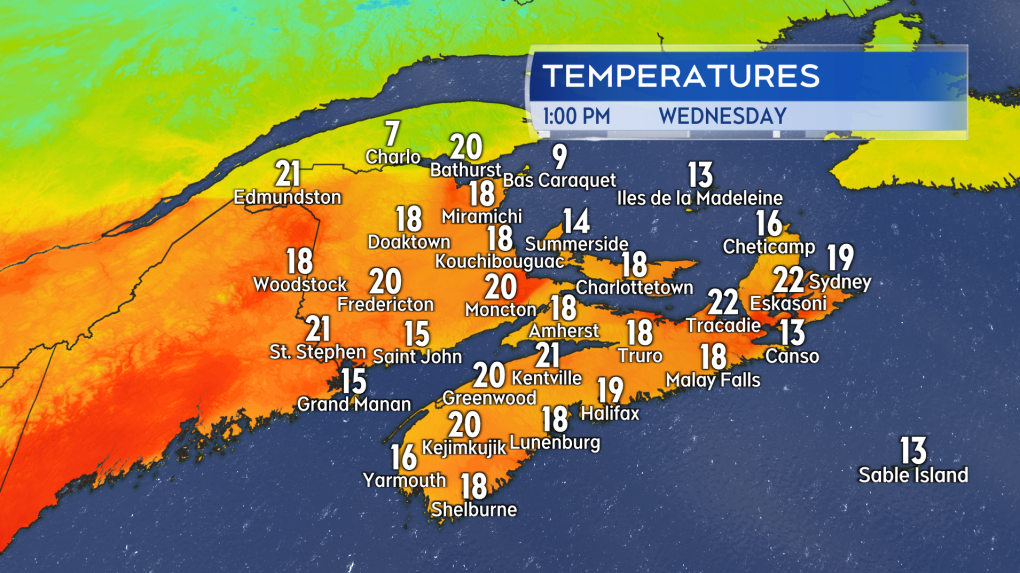
As you can see, they are quite warm, ranging 19-to-25 degrees, with most records set in 2022. Temperatures just after noon on Wednesday reached a range of 17-to-21 degrees for many communities in the Maritimes. While it’s unlikely to see most of the previous records broken, it is certainly possible temperatures Wednesday could approach or exceed those records for a few communities.
 Temperatures early Wednesday afternoon starting to approach standing records for a Nov. 6 in the Maritimes. (Source: CTV News Atlantic)
Cold front and cooling temperatures
A cold front associated with an area of low pressure moving through Labrador will cross the Maritimes Wednesday night.
The front will change the wind direction to the northwest, which will usher cooler air out of northern Quebec towards the Maritimes Thursday and Friday. A second cold front will drop temperatures another few degrees for the weekend.
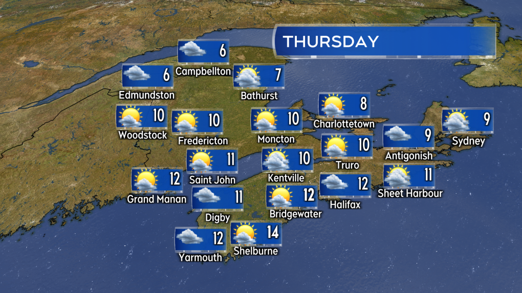
It will be seasonably cool for Thursday and Friday. High temperatures will range six-to-10 degrees for much of the Maritimes. Southwestern New Brunswick and Atlantic coastal Nova Scotia will be a touch milder with high temperatures 10-to-14 degrees.
 A mix of sun and cloud Thursday with a prevailing northwest wind bringing temperatures closer to seasonable. (Source: CTV News Atlantic)
Hurricane Rafael
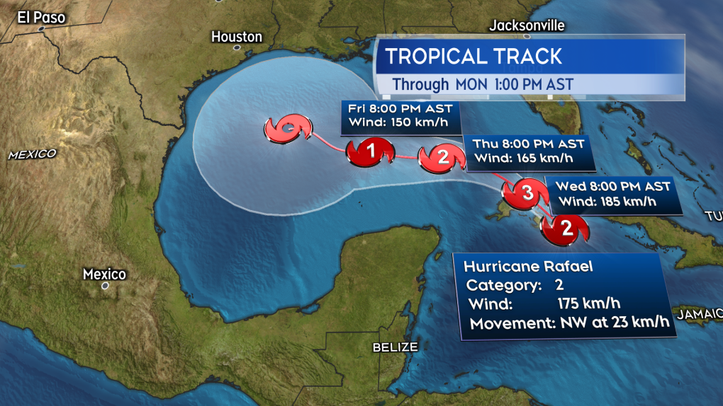
Hurricane Rafael was approaching a landfall in western Cuba on the coastal area just south of San Cristobal Wednesday afternoon as a category-two hurricane with maximum sustained winds near 175 km/h.
Western Cuba is under a Hurricane Warning with hazards including storm surge, damaging winds, destructive waves, and flooding rain that could total between 200 and 300 mm for some areas.
 Hurricane Rafael will cross western Cuba on Wednesday before moving into the Gulf of Mexico. (Source: CTV News Atlantic)
Rafael may strengthen to a category-three hurricane as it emerges from Cuba over the Gulf of Mexico Wednesday evening. From there it is currently forecast to weaken to a category-one hurricane over the central Gulf of Mexico on Friday. The Gulf States will have to monitor the progress of the storm through the weekend for potential impacts.
There is no risk of the storm to the Maritimes in the long-range forecast.
CTVNews.ca Top Stories

5 rescued after avalanche triggered north of Whistler, B.C. RCMP say
Emergency crews and heli-skiing staff helped rescue five people who were caught up in a backcountry avalanche north of Whistler, B.C., on Monday morning.
Quebec fugitive killed in Mexican resort town, RCMP say
RCMP are confirming that a fugitive, Mathieu Belanger, wanted by Quebec provincial police has died in Mexico, in what local media are calling a murder.
Bill Clinton hospitalized with a fever but in good spirits, spokesperson says
Former President Bill Clinton was admitted Monday to Georgetown University Medical Center in Washington after developing a fever.
Trump again calls to buy Greenland after eyeing Canada and the Panama Canal
First it was Canada, then the Panama Canal. Now, Donald Trump again wants Greenland. The president-elect is renewing unsuccessful calls he made during his first term for the U.S. to buy Greenland from Denmark, adding to the list of allied countries with which he's picking fights even before taking office.
UN investigative team says Syria's new authorities 'very receptive' to probe of Assad war crimes
The U.N. organization assisting in investigating the most serious crimes in Syria said Monday the country’s new authorities were “very receptive” to its request for cooperation during a just-concluded visit to Damascus, and it is preparing to deploy.
Pioneering Métis human rights advocate Muriel Stanley Venne dies at 87
Muriel Stanley Venne, a trail-blazing Métis woman known for her Indigenous rights advocacy, has died at 87.
King Charles ends royal warrants for Ben & Jerry's owner Unilever and Cadbury chocolatiers
King Charles III has ended royal warrants for Cadbury and Unilever, which owns brands including Marmite and Ben & Jerry’s, in a blow to the household names.
Man faces murder charges in death of woman who was lit on fire in New York City subway
A man is facing murder charges in New York City for allegedly setting a woman on fire inside a subway train and then watching her die after she was engulfed in flames, police said Monday.
Canada regulator sues Rogers for alleged misleading claims about data offering
Canada's antitrust regulator said on Monday it was suing Rogers Communications Inc, for allegedly misleading consumers about offering unlimited data under some phone plans.


