No need to dream, White Christmas all but assured in the Maritimes
Thanks to an early season nor’easter followed by a period of cold weather, much of the Maritimes has a good layer of snow on the ground. Another low-pressure system will swing out of the Great Lakes and bring further snowfall to the Maritimes on Tuesday, all but ensuring a white Christmas.
Weekend snow reports
The snow piled up for a large portion of the Maritimes this past weekend thanks to the nor’easter and localized snow squalls.
The nor’easter brought 10 to 30 cm of snow across much of southern and eastern New Brunswick, Nova Scotia, and Prince Edward Island. Snow totals climbed higher for areas that saw flurries and squalls move in off ocean waters. Reports from the North Shore for mainland Nova Scotia and the Cape Breton Highlands show as much as 40 to 50 cm of snow fell Friday night through Monday morning.
Snow squalls continue Monday afternoon for Inverness and Victoria Counties in Cape Breton. The squalls are expected to diminish through Monday evening.
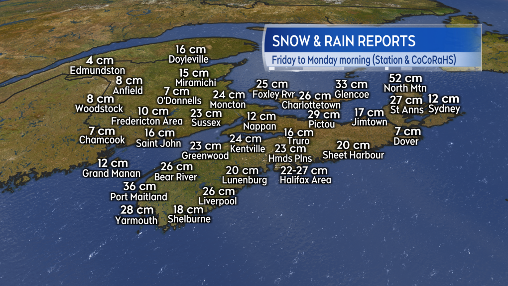 Snow reports from weather stations and volunteers Friday through Monday morning.
White Christmas outlook
A “White Christmas” requires 2 cm of snow on the ground Christmas morning by definition. A “Perfect Christmas” requires 2 cm of snow on the ground accompanied by falling snow.
Modelling shows the majority of the Maritimes should see the required 2 cm of snow on Christmas morning thanks to the nor’easter and second weather system expected Tuesday. There is a chance some flurries and areas of light snow will linger into Wednesday morning. Western Nova Scotia has the highest chance of falling snow Christmas day.
The chances for a White Christmas in each of the Maritime capital cities is 44 per cent for Charlottetown, 40 per cent for Frederiction, and 32 per cent for Halifax based on averages for the last few decades.
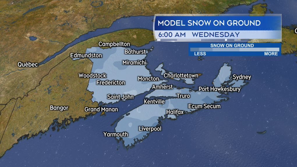 There will be some local variation but much of the Maritimes is expected to have 2 cm or more of snow on the ground for Christmas morning.
More snow to come
A low-pressure system moving out of the Great Lakes region will bring snowfall to the Maritimes Tuesday.
Snow will develop across much of New Brunswick early Tuesday morning and move across Nova Scotia and Prince Edward Island by noon. The snow will be heavy at times in parts of southern New Brunswick and western Nova Scotia.
The snow will continue into Tuesday evening but by midnight it will have diminished, leaving a chance of flurries for most of the Maritimes with the exception of coastal areas along the Bay of Fundy in New Brunswick and southwestern Nova Scotia. Those areas look like they will see the highest overall snowfall.
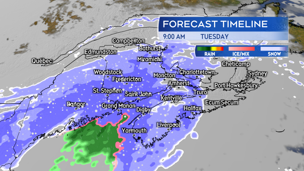 Snow develops across the Maritimes Tuesday morning, continues for the afternoon and for some areas through the evening.
Much of southern New Brunswick and mainland Nova Scotia is under a Special Weather Statement that calls for 5 to 15 cm Tuesday through Wednesday morning.
Snowfall Warnings have been posted for the Kennebecasis Valley and Bay of Fundy area of New Brunswick as well as western Cumberland County, the Annapolis Valley and southwest of Nova Scotia. The warnings call for 15 cm of snow or more in 12 hours or less starting Tuesday morning. The weather agency says additional snow may be possible through the day on Wednesday.
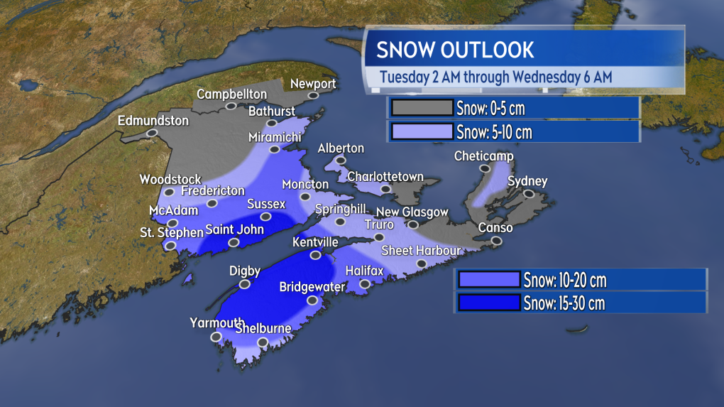 An outlook into potential snow early Tuesday morning through early Wednesday morning.
CTVNews.ca Top Stories

BREAKING 5 rescued after avalanche triggered north of Whistler, B.C. RCMP say
Emergency crews and heli-skiing staff helped rescue five people who were caught up in a backcountry avalanche north of Whistler, B.C., on Monday morning.
Quebec fugitive killed in Mexican resort town, RCMP say
RCMP are confirming that a fugitive, Mathieu Belanger, wanted by Quebec provincial police has died in Mexico, in what local media are calling a murder.
Bill Clinton hospitalized with a fever but in good spirits, spokesperson says
Former President Bill Clinton was admitted Monday to Georgetown University Medical Center in Washington after developing a fever.
Trump again calls to buy Greenland after eyeing Canada and the Panama Canal
First it was Canada, then the Panama Canal. Now, Donald Trump again wants Greenland. The president-elect is renewing unsuccessful calls he made during his first term for the U.S. to buy Greenland from Denmark, adding to the list of allied countries with which he's picking fights even before taking office.
Pioneering Métis human rights advocate Muriel Stanley Venne dies at 87
Muriel Stanley Venne, a trail-blazing Métis woman known for her Indigenous rights advocacy, has died at 87.
King Charles ends royal warrants for Ben & Jerry's owner Unilever and Cadbury chocolatiers
King Charles III has ended royal warrants for Cadbury and Unilever, which owns brands including Marmite and Ben & Jerry’s, in a blow to the household names.
Man faces murder charges in death of woman who was lit on fire in New York City subway
A man is facing murder charges in New York City for allegedly setting a woman on fire inside a subway train and then watching her die after she was engulfed in flames, police said Monday.
Canada regulator sues Rogers for alleged misleading claims about data offering
Canada's antitrust regulator said on Monday it was suing Rogers Communications Inc, for allegedly misleading consumers about offering unlimited data under some phone plans.
Multiple OnlyFans accounts featured suspected child sex abuse, investigator reports
An experienced child exploitation investigator told Reuters he reported 26 accounts on the popular adults-only website OnlyFans to authorities, saying they appeared to contain sexual content featuring underage teen girls.


