Philippe declared post-tropical, still a large fall storm for the Maritimes
In the Friday noon update from the National Hurricane Center, Philippe was declared a post-tropical storm.
That does not mean a weakening of the storm. It does mean the structure of the storm has changed. It now has non-tropical characteristics, such as developing weather fronts and an asymmetrical appearance. The transition to post-tropical was forecasted and expected.
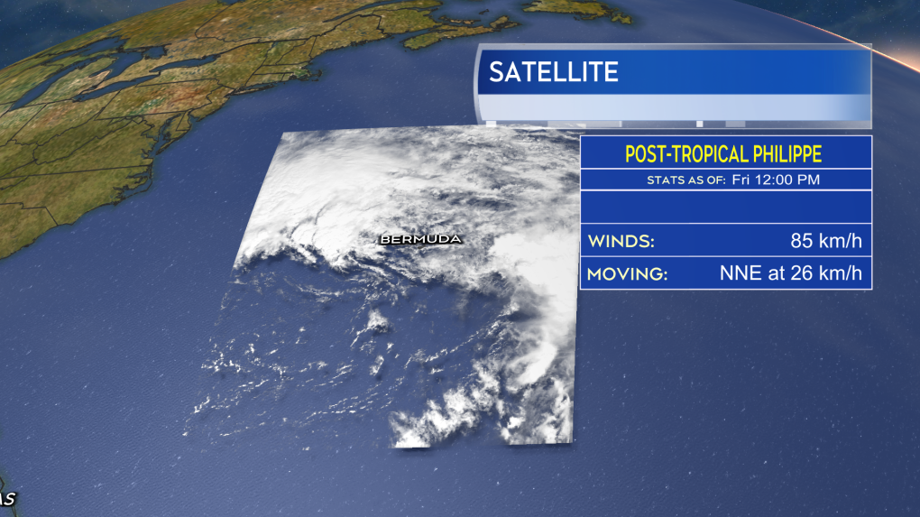 Now with non-tropical characteristics, including developing weather fronts, Philippe has been declared post-tropical.
Post-tropical storm Philippe will still continue north with the centre expected to pass just to the south of southwestern Nova Scotia before moving through Maine and into the St. Lawrence River Valley on Sunday.
As Philippe moves along that path, it will combine with a separate weather front to create a large area of low pressure -- the fall storm we are expecting.
Due to it now being post-tropical, the Canadian Hurricane Centre has decided against issuing tropical storm watches and tropical storm warnings. Instead, they are advising to monitor for separate alerts, such as rain or wind warnings from the regional weather office.
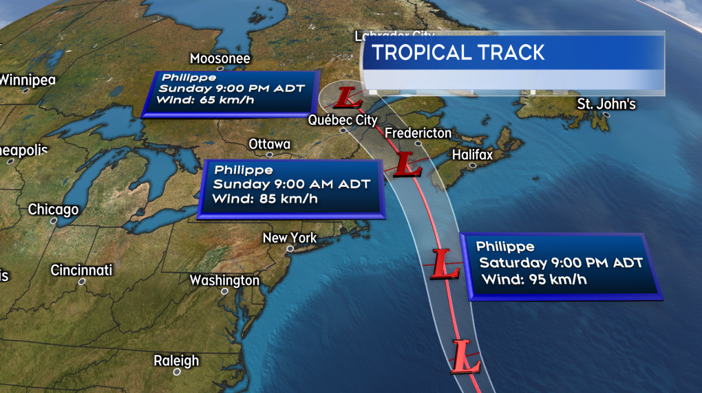 The track of post-tropical storm Philippe still takes it into the vicinity of the Maritimes where it combines with a weather front to produce a large fall storm.
NEW BRUNSWICK
It still looks like New Brunswick will contend with the rainiest and windiest conditions Saturday night through Sunday morning. The highest wind will be out of the east and southeast, with most gusts peaking between 40 and 80 km/h. I’d still rate a risk of stronger gusts of 80 to 90 km/h on and near the Bay of Fundy coastline as well as coastal areas of the Acadian Peninsula. Wind is still expected to turn southerly and diminish Sunday afternoon.
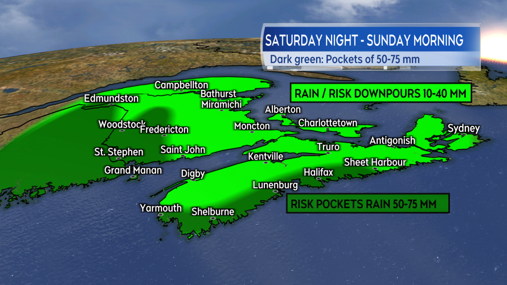
Rain will develop southwest to northeast across the province Saturday evening and night. The rain will persist into Sunday morning, but is expected to ease to a chance of showers for Sunday afternoon and evening. The highest risk of rain totals reaching 50 to 75 mm is along the border of New Brunswick and Maine. A lower risk of those higher rain amounts extends as far to the east as about the Fredericton area. Much of the rest of New Brunswick is likely to see totals ranging from 10 to 40 mm.
While wave action will increase in the Bay of Fundy Saturday night into Sunday, they are not expected to have much coastal impact.
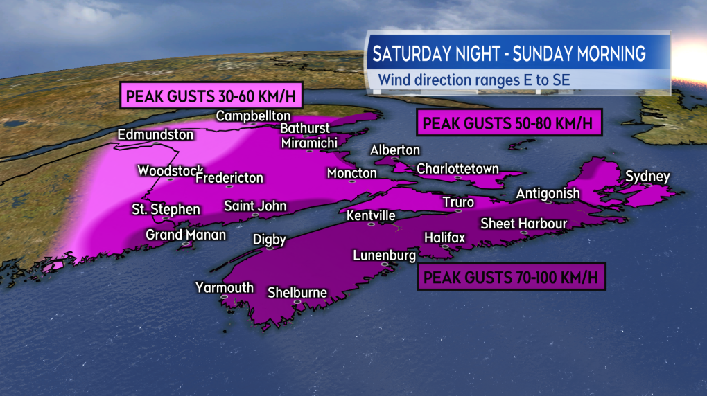 An outlook into peak wind gusts expected in the Maritime region with Philippe, with most of those occurring Saturday night and Sunday morning.
NOVA SCOTIA
Nova Scotia will see if most impact from post-tropical storm Philippe Saturday night through Sunday morning. Windy conditions could linger later into Sunday afternoon for eastern parts of the mainland and Cape Breton. The highest, gusty winds will be out of the east and southeast. For most of the province those winds will peak between 60 and 90 km/h. Exposed areas of the Atlantic coastline, particularly coastal areas of Yarmouth, Shelburne, Queens, and Lunenburg Counties, could see gusts as high as near 100 km/h. Northern Inverness County in Cape Breton could also hit some gusts of 100 km/h or higher on Sunday due to the topography of the Highlands.
Wind is expected to turn southwest and diminish by near noon Sunday for western Nova Scotia. For eastern parts of the province, the wind will turn southwest and diminish by the evening.
The rain may reach southwestern Nova Scotia late Saturday afternoon and develop across the province west-to-east Saturday night through Sunday morning. While not on the traditionally “rainy western side” of the storm, there is a risk of downpours within the rain. The greatest risk of rain pockets with totals of 50 to 75 mm is for counties that border the Atlantic coastline of the province. Widespread rain totals of 20 to 40 mm are expected provincewide. The rain is expected to clear western areas of Nova Scotia by noon on Sunday before clearing eastern areas, including Cape Breton, through Sunday afternoon.
While not matching Lee, large waves from Philippe are forecast for the South Shore and Halifax County Saturday night and Sunday morning. The greatest risk of elevated coastal water levels during high tide will occur between 4 a.m. and 5 a.m. for that area on Sunday. The Canadian Hurricane Centre notes some wave overwash and minor/moderate coastal flooding is a risk during those very early morning hours of Sunday.
 While rain totals for most of the region are not overly high, there is still a risk that it could come in the form of downpours at times.
PRINCE EDWARD ISLAND & MAGDALEN ISLANDS
Prince Edward Island and the Magdalen Islands will get into the rainy and windy weather in earnest early Sunday morning. The highest winds will be out of the east and southeast, with gusts mostly expected to peak 60 to 80 km/h. Areas of the coast more exposed to the east could reach gusts closer to 90 km/h. Windy conditions will persist through Sunday morning then gradually diminish in the afternoon into the evening.
Rain accompanying the wind will be in the range of 15 to 30 mm -- that shouldn’t cause much issue. Like the wind, the rain will ease and clear through Sunday afternoon.
Some increased wave action is expected in the Gulf of St. Lawrence and Northumberland Strait on Sunday. The risk of coastal flooding remains low.
IN SUMMARY
Despite having a component that was originally tropical in nature, Philippe has all the marking of a strong, fall storm for the region. In general, the impacts are expected to be less than those with post-tropical storm Lee. While there is still a risk of power outages with the high and gusty winds, they are likely to be more scattered or isolated in occurrence.
While the risk of heavier rain is highest for a few particular areas, it would be a good idea to check drainage on properties. Make sure spouts and drains are free and clear of any early fall debris so the rain can flow away as unobstructed as possible.
I’ll have additional updates and coverage on the weather this weekend. That can all be found here at ctvnewsatlantic.ca.
Shopping Trends
The Shopping Trends team is independent of the journalists at CTV News. We may earn a commission when you use our links to shop. Read about us.


CTVNews.ca Top Stories

Fall sitting bookended by Liberal byelection losses ends with Trudeau government in tumult
The House of Commons adjourned on Tuesday, bringing an end to an unstable fall sitting that has been bookended by Liberal byelection losses. The conclusion of the fall sitting comes as Prime Minister Justin Trudeau's minority government is in turmoil.
2 B.C. police officers charged with sexual assault
Two officers with a Vancouver Island police department have been charged with the sexual assault of a "vulnerable" woman, authorities announced Tuesday.
Canadian government announces new border security plan amid Donald Trump tariff threats
The federal government has laid out a five-pillared approach to boosting border security, though it doesn't include specifics about where and how the $1.3-billion funding package earmarked in the fall economic statement will be allocated.
B.C. teacher disciplined for refusing to let student use bathroom
A teacher who refused to let a student use the bathroom in a B.C. school has been disciplined by the province's professional regulator.
Most Canadians have heard about Freeland's resignation from Trudeau cabinet, new poll finds
The majority of Canadians heard about Chrystia Freeland's surprise resignation from Prime Minister Justin Trudeau's cabinet, according to a new poll from Abacus Data released Tuesday.
Police chief says motive for Wisconsin school shooting was a 'combination of factors'
Investigators on Tuesday are focused on trying to determine a motive in a Wisconsin school shooting that left a teacher and a student dead and two other children in critical condition.
After investigating Jan. 6, House GOP sides with Trump and goes after Liz Cheney
Wrapping up their own investigation on the Jan. 6 2021 Capitol attack, House Republicans have concluded it's former GOP Rep. Liz Cheney who should be prosecuted for probing what happened when then-President Donald Trump sent his mob of supporters as Congress was certifying the 2020 election.
Wine may be good for the heart, new study says, but experts aren’t convinced
Drinking a small amount of wine each day may protect the heart, according to a new study of Spanish people following the plant-based Mediterranean diet, which typically includes drinking a small glass of wine with dinner.
The Canada Post strike is over, but it will take time to get back to normal, says spokesperson
Canada Post workers are back on the job after a gruelling four-week strike that halted deliveries across the country, but it could take time before operations are back to normal.
Toronto
-

Two men charged in death of Markham real estate agent as search continues for murder suspect
Two people have been charged in connection with the disappearance and death of a Markham real estate agent whose remains were found in Parry Sound over the summer.
-
2 people seriously injured in Scarborough shooting
Toronto police say two people have been injured in a shooting in Scarborough.
-
Canadian government announces new border security plan amid Donald Trump tariff threats
The federal government has laid out a five-pillared approach to boosting border security, though it doesn't include specifics about where and how the $1.3-billion funding package earmarked in the fall economic statement will be allocated.
Calgary
-

Calgary man pleads guilty to manslaughter in 2022 shootings
A Calgary man was sentenced to 16 years in jail after pleading guilty to manslaughter in connection with two 2022 shootings.
-
'Condensed timeline' puts pressure on Calgary council to approve Green Line project
With timelines tightening, Calgary city council is asking for an urgent meeting with the Alberta government to discuss a reworked plan to build a multibillion-dollar light-rail-transit line connecting the city's southeast to downtown.
-
Sexual assault, breach of trust charges laid against former Calgary police officer
Vancouver police say Sgt. Matthew Ball and Const. Ryan Johnston, both of the Central Saanich Police, formed separate "intimate" and "inappropriate" relationships with a woman in her mid-20s they met while on duty.
Edmonton
-

Police officer hurt, 2 arrested after gun fight reported at Stantec Tower
A police officer and two men were taken to hospital on Tuesday after an arrest at Stantec Tower.
-
Caught on camera: Porch pirate steals dirty diapers from Edmonton step
A would-be thief got away with a bag of dirty diapers after snagging what they thought was a package off an Edmonton porch.
-
Lots of snow and some serious cold coming to Edmonton region Wednesday
Prepare for a significant dump of heavy snow Wednesday.
Montreal
-

69-year-old woman dies after being struck by city bus in Montreal-North
Montreal police (SPVM) have confirmed that a pedestian has died after a collision with an STM bus in the Montreal-North borough on Tuesday evening.
-
Major fire in Montreal-North apartment building leaves 30 families homeless
The Montreal Fire Service battled a three-alarm fire in Montreal-North on Tuesday evening.
-
Another woman testified against Just for Laughs founder as civil trial continues
The civil lawsuit against Gilbert Rozon, founder of Just for Laughs, continued Monday as nine women seek damages, alleging sexual assault by Rozon.
Ottawa
-

Inquest jury deems Abdirahman Abdi's death after arrest a homicide, makes recommendations
The jury at a coroner's inquest deemed the 2016 death of an Ottawa man after his violent arrest a homicide, as it made more than 50 recommendations Tuesday aimed at preventing similar deaths in the future.
-
Villa Marconi, board refute union allegations about hygiene care
The chair of the board of directors at Villa Marconi, a long-term care facility on Baseline Road, says allegations around supply shortages leading to neglect of resident hygiene are "all false."
-
Ottawa Public Health asking customers of south Ottawa Tim Hortons to monitor for hep A symptoms
Ottawa Public Health is warning residents about a possible risk of exposure to hepatitis A at a local Tim Hortons in the city's south end.
London
-
 WATCH
WATCHWATCH Supporters of Councillor Stevenson disrupt council meeting that imposed 30-day suspension of pay for bullying staff
Coun. Susan Stevenson has been docked 30-days’ pay after an investigation by the Integrity Commissioner determined she bullied and harassed a senior city staffer.
-
London man sentenced for his role in shooting death
A London man has been sentenced for his role in the shooting death of Josue Silva.
-
Death investigation underway in Hanover
Officials have released few details about a death investigation in Hanover.
Barrie
-

'We've been scammed,' Customers allege floating home company owner left them in limbo after payment
Several customers of a floating home company say their dream of living on the water has turned into a financial and emotional nightmare.
-
New taser technology put to the test as Barrie police undergo training
Police officers in Barrie participated in a jolting experience on Monday as they voluntarily felt the effects of a new conducted energy weapon during an intensive training session.
-
Two drivers nabbed for allegedly speeding over 150km/h on Highway 11
Police patrolling Highway 11 in Orillia pulled over two vehicles on Tuesday morning, each allegedly travelling more than 60 kilometres per hour over the posted limit.
Northern Ontario
-

Two in northern Ont. charged with manslaughter in death of a child
Two people have been charged with manslaughter and other offences in connection with the death of a seven-year-old two years ago in Hearst, Ont.
-
'There's just no rhyme or reason': Sault gun shop owners frustrated by additions to gun ban
The federal government’s recent expansion of its gun buy-back program has frustrated firearm owners and sellers in the Sault Ste. Marie area.
-
Volunteer firefighters in Markstay-Warren say they have been harassed by local councillor
Volunteer firefighters in Markstay-Warren say they have had enough of what they call unfair public scrutiny from a local municipal councillor.
Kitchener
-

Victim of Cambridge, Ont. dog attack claims same animal is up for adoption without disclosure
A Cambridge, Ont. woman who was involved in a vicious dog attack this summer claims one of the dogs involved is now up for adoption.
-
Cambridge kitchen fire results in serious burn injuries
One person was taken to hospital with serious burns after a fire Tuesday at a Cambridge apartment complex.
-
3 suspects wanted following jewelry store robbery at Cambridge Centre Mall
Police said they were called to the shopping centre on Hespeler Road around 8:15 p.m. Monday for reports of a robbery at a jewelry store.
Windsor
-

Canada Post strike ends, but Windsor businesses still feel the pain
While small businesses in Windsor are relieved to see Canada Post moving again, many are still feeling the sting of the four-week work stoppage.
-
Shots fired at home in east Windsor
Windsor police are looking for a suspect after multiple shots were fired at a home in east Windsor.
-
Windsor transitional home gets a helping hand ahead of the holidays
A Windsor philanthropist has donated an abundance of food for those seeking help at a sober living transition home on Windsor's west side ahead of the holidays.
Winnipeg
-

'Drastic measures' needed as Manitoba faces $1.3B deficit, experts say
With both Manitoba and Canada facing deficits far exceeding what they had hoped, experts warn drastic measures will be needed but fear Manitobans will be the ones paying.
-
Winnipeg to start exploring the potential of 24-hour firefighter shifts
Firefighters in Winnipeg could one day work around the clock, like they already do in other cities.
-
One arrested following school threats: Winnipeg police
The Winnipeg Police Service is providing more details about three threats made toward two schools Monday and Tuesday, which resulted in the arrest of a 13-year-old girl.
Regina
-

Conflict of Interest Commissioner recommends reprimand for Health Minister Jeremy Cockrill
Saskatchewan's Conflict of Interest Commissioner (COIC) is recommending a reprimand for Health Minister Jeremy Cockrill after finding he broke legislative rules when a company tied to his family participated in government contracts.
-
Chappell Roan 'looking at venues' for possible Sask. show
American singer-songwriter Chappell Roan is expressing some interest towards performing in Saskatchewan – after shouting out the province in a yet to be released song.
-
Sask. local businesses seeing holiday sales dip due to Canada Post strike
Canada Post employees are heading back to work after a month-long dispute – leading many local businesses to breathe a sigh of relief. However, business is not back to usual just yet.
Saskatoon
-

First Nation leaders push to close 'loophole' laws after judge stays fatal THC-impaired driving charge
The Federation of Sovereign Indigenous Nations (FSIN) wants to change the Criminal Code of Canada to prioritize victims that are children.
-
'She was fiercely competitive': Saskatoon historic Olympic medal winner honoured
One of Saskatoon’s most famous Olympians finally gets her official recognition — and it’s been almost a century in the making.
-
Sask. local businesses seeing holiday sales dip due to Canada Post strike
Canada Post employees are heading back to work after a month-long dispute – leading many local businesses to breathe a sigh of relief. However, business is not back to usual just yet.
Vancouver
-

City staff recommend demolition for derelict vacant building in downtown Vancouver
The City of Vancouver’s chief building official has deemed a 176-room hotel in the heart of the city’s downtown too derelict and poorly maintained to remain standing.
-
2 B.C. police officers charged with sexual assault
Two officers with a Vancouver Island police department have been charged with the sexual assault of a "vulnerable" woman, authorities announced Tuesday.
-
'It's another Hail Mary pass by the Trudeau government': Experts and B.C. businesses react as GST holiday begins
B.C. businesses have been left scrambling to make the federal government's decision to slash GST for the holidays a reality.
Vancouver Island
-

2 B.C. police officers charged with sexual assault
Two officers with a Vancouver Island police department have been charged with the sexual assault of a "vulnerable" woman, authorities announced Tuesday.
-
Langford council votes unanimously in favor of purchasing Westhills Langford Aquatic Centre
Langford city council has voted unanimously in favor of purchasing the Westhills Langford Aquatic Centre for the price of $35 million. The facility's largest tenant is the YMCA/YWCA, which operates the municipality's only public pool.
-
Tofino Harbour Authority closed due to standoff with 'squatter,' agency says
The Tofino Harbour Authority says it has temporarily shuttered its office in the coastal Vancouver Island community due to an escalating standoff with the operator of a so-called "squatter" vessel.
Kelowna
-

B.C. man sentenced for 'execution-style' murder of bystander in drug trade conflict
A B.C. man convicted of the "intentional and ruthless killing of a bystander" while acting as an enforcer in the drug trade has been sentenced for a second time in the slaying.
-
Paramedic threatened at knifepoint inside Kelowna ambulance station, union says
The union representing ambulance paramedics in B.C. is calling on the province to beef up security after they say a knife-wielding woman attacked a worker.
-
Car stolen, fleeing suspect found hiding in basement in Kelowna, B.C.
Mounties have arrested a suspect who allegedly stole a car in Kelowna, B.C., before fleeing on foot and hiding from police in the basement of a home.


