Rainfall warnings issued with fall storm expected in the Maritimes Saturday
More weather alerts are in effect for the Maritimes ahead of heavy rain and high wind expected for parts of the region Saturday.
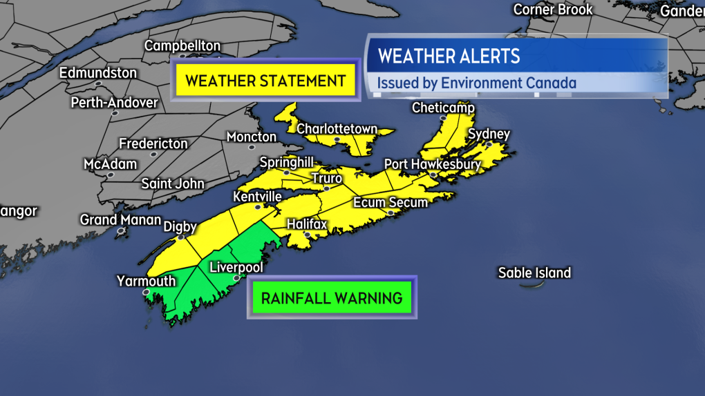 Rainfall warnings and special weather statements issued for the Maritimes as of noon Friday.
A rainfall warning had been issued by Environment Canada for the South Shore of Nova Scotia. The warning calls for “50 to 80 mm, with locally higher amounts possible.” The weather agency is also cautioning “heavy downpours can cause flash floods and water pooling on roads. Localized flooding in low-lying areas is possible.”
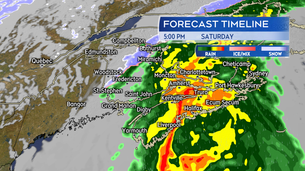 Rain and downpours present across a large part of the Maritimes Saturday afternoon, evening, and night. Some wet snow is expected in northern areas of New Brunswick.
A special weather statement extends across the remainder of Nova Scotia, Prince Edward Island, and the Magdalen Islands. The statement is calling for potential rain totals of 50 to 80+ mm for Nova Scotia and 40 to 60+ mm for Prince Edward Island and the Magdalen Islands. That is a similar amount of rain expected in the areas under the rainfall warning. I spoke to an Environment Canada official and they explained that the heaver rain is expected to reach the South Shore of Nova Scotia first on Saturday, which is why that area is currently under the warning. They mentioned that further areas under the special weather statement are likely to be placed into the rainfall warning later on Friday.
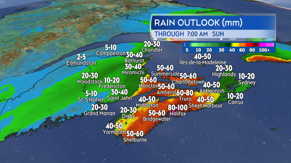 Rain, including downpours, is expected to bring totals of 50-100 mm for parts of Nova Scotia, Prince Edward Island, and southern New Brunswick.
The statement also includes information on winds. For Nova Scotia, southerly gusts of 70 to 90 km/h are possible for eastern parts of the province Saturday evening and night. Northern Inverness County in Cape Breton will experience peak gusts of 120 km/h Saturday night due to the topography of the Highlands. Gusts of 60 to 80 km/h are mentioned for P.E.I. Saturday night. There will be southerly gusts near 90 km/h for the Magdalen Islands Saturday night.
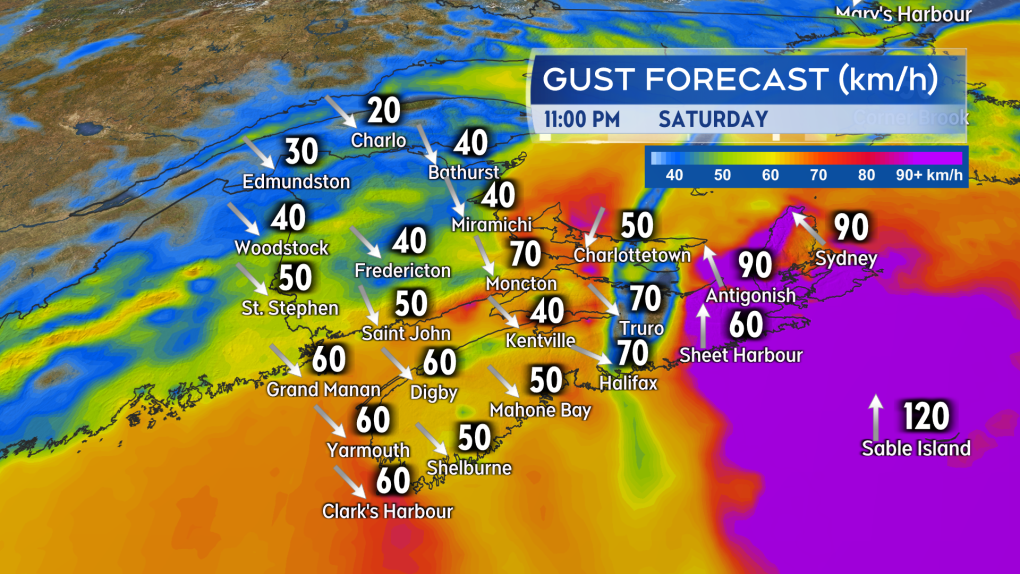 Some of the stronger southerly winds are expected to blow across eastern areas of Nova Scotia Saturday night.
While there were no weather alerts in effect for New Brunswick as of noon Friday, parts of the province could still experience downpours within the rain. The greatest risk of those downpours is along the Bay of Fundy coastline and into Moncton and the southeast. Some wet snow is expected to mix with rain in northern areas of New Brunswick. Accumulation in the snow looks to be generally less than 5 cm with the exception of some of the more mountainous terrain, which could pick up 5 to 10 cm in the higher elevations.
If you are in an area expecting heavier rain, check to make sure property drainage and gutters are free from seasonal debris. If you use a sump pump in heavy rain events, make sure it is in working order. Be cautious travelling on roads in heavy rain, as visibility will be reduced and hydroplaning conditions present.
A number of outdoor events have been cancelled or postponed in the region Saturday. If you were participating or attending an outdoor event it would be best to check on its current status.
I’ll have live timelines of the rain and wind, weather alert updates, and the extended forecast on CTV News Atlantic 5, 6, and 11:30 p.m.
Shopping Trends
The Shopping Trends team is independent of the journalists at CTV News. We may earn a commission when you use our links to shop. Read about us.


CTVNews.ca Top Stories

Trudeau considering his options as leader after Freeland quits cabinet, sources say
Chrystia Freeland, Canada's finance minister, said in an explosive letter published Monday morning that she will quit cabinet. Here's what happened on Monday, Dec. 16.
'We're not united': Liberal caucus meets, as PM Trudeau faces fresh calls to resign in light of Freeland's departure
The federal Liberals called an emergency caucus meeting Monday night, as Prime Minister Justin Trudeau faced renewed calls from some members of his party to resign. As MPs emerged, the message was mixed.
'Eventful day,' Trudeau says after Chrystia Freeland quits cabinet, LeBlanc tapped to replace her
In a stunning move, Deputy Prime Minister and Finance Minister Chrystia Freeland announced her resignation from Justin Trudeau's cabinet on Monday, after the prime minister told her he no longer wanted her in the top economic post. After hours of turmoil, Dominic LeBlanc, was sworn-in as her replacement in the finance portfolio.
Feds deliver fall economic statement with $61.9B deficit for 2023-24, amid political turmoil
Amid the news that Chrystia Freeland has resigned from her cabinet position as finance minister, the Department of Finance on Monday unveiled the long-anticipated fall economic statement, which reports a deficit of $61.9-billion for 2023-24.
W5 Investigates
W5 Investigates Connecting the dots on a landlord scam: how clues revealed a prolific con artist at work
In part one of a three-part investigation, W5 correspondent Jon Woodward reveals how a convicted con artist bilked dozens of people in a landlord scam.
Judge rules Trump does not have presidential immunity protections in hush money conviction
Donald Trump's felony conviction in the New York hush money case should not be tossed out because of the Supreme Court's ruling on presidential immunity.
Canadian hero Terry Fox being featured on next $5 bill
The federal government is paying tribute to Canadian hero Terry Fox by featuring him on the next $5 bank note, officials revealed Monday.
Wisconsin school shooter who killed teacher, student was 17-year-old girl, police say
A teenage student opened fire with a handgun Monday at a Christian school in Wisconsin, killing a teacher and another teenager during the final week before Christmas break. The shooter also died, police said.
Travel risk: Which countries does Canada recommend avoiding?
Canadians planning to travel abroad over the holidays should take precautionary steps to ensure they're not unintentionally putting themselves in harm's way.
Toronto
-
Trudeau considering his options as leader after Freeland quits cabinet, sources say
Chrystia Freeland, Canada's finance minister, said in an explosive letter published Monday morning that she will quit cabinet. Here's what happened on Monday, Dec. 16.
-
Feds deliver fall economic statement with $61.9B deficit for 2023-24, amid political turmoil
Amid the news that Chrystia Freeland has resigned from her cabinet position as finance minister, the Department of Finance on Monday unveiled the long-anticipated fall economic statement, which reports a deficit of $61.9-billion for 2023-24.
-
Teen seriously injured in north-west Toronto shooting
A teen has been seriously injured in a shooting on Monday night in north-west Toronto.
Calgary
-
Trudeau considering his options as leader after Freeland quits cabinet, sources say
Chrystia Freeland, Canada's finance minister, said in an explosive letter published Monday morning that she will quit cabinet. Here's what happened on Monday, Dec. 16.
-
Tear test, stretch test and more: How to figure out what to recycle from the holidays
According to the City of Calgary, people living in the city generate about 25 per cent more waste 'during the Christmas season, but recycling doubles and a lot of what's in the blue bins shouldn't be there.'
-
12-year-old boy hit by car, Calgary police urge public to step up
Calgary police are urging witnesses to come forward after a young boy was hit by a car in the community of Belmont last week.
Edmonton
-

Smith, premiers vow to support stability, unity in wake of federal government chaos
Alberta's premier is among provincial leaders promising Canadians stability and unity as fractures form within the federal government.
-
Woman arrested after child abuse complaint on flight from Toronto to Edmonton: RCMP
A woman was taken into custody after a possible case of child abuse was reported on a flight bound to Edmonton.
-
Trudeau considering his options as leader after Freeland quits cabinet, sources say
Chrystia Freeland, Canada's finance minister, said in an explosive letter published Monday morning that she will quit cabinet. Here's what happened on Monday, Dec. 16.
Montreal
-

Jury delivers guilty verdicts for accused in Montreal-area triple homicide trial
The accused in a triple homicide trial south of Montreal has been found guilty.
-
Montreal Liberal MP Anthony Housefather says Trudeau should resign
Montreal MP Anthony Housefather has joined the number of Liberals who are calling on Prime Minister Justin Trudeau to step aside, saying Monday that he believes the party leader is "past his shelf life."
-
Six hospitalized as power outage continues in Montreal's Saint-Michel neighbourhood
Six people were hospitalized for carbon monoxide poisoning as hundreds remain without power in Montreal's Saint-MIchel neighbourhood for a third day.
Ottawa
-

Federal government reviving Kettle Island bridge idea with 'commitment' to new interprovincial crossing
The federal government's fall economic statement says the government is announcing its commitment to building a new bridge over the Ottawa River to connect Ottawa and Gatineau, reviving a controversial proposal that faced major public backlash more than 10 years ago.
-
Have a look inside Ottawa's new Trillium Line
The countdown is on for the launch of the Ottawa's new north-south LRT line in the new year.
-
Trudeau considering his options as leader after Freeland quits cabinet, sources say
Chrystia Freeland, Canada's finance minister, said in an explosive letter published Monday morning that she will quit cabinet. Here's what happened on Monday, Dec. 16.
London
-

Collision on Longwoods Road sends one person to hospital with serious injuries
According to police, one person has been taken to hospital with serious injuries as the result of a collision west of Lambeth.
-
Councillor Stevenson seeking federal Conservative nomination in London Centre
Representing Ward 4 at city hall since November 2022, Stevenson is seeking the Conservative Party of Canada (CPC) nomination in the new federal riding of London Centre.
-
Staff and students get a sneak preview of London's newest elementary school
The $22.3 million, 507-student school is located in northwest London, near Hyde Park Road and Sunningdale Road and boasts some subtle quality of life improvements for students and staff.
Barrie
-

Pickup truck driver killed in head-on crash with dump truck: OPP
One person has died in a collision involving a dump truck south of Beaverton Monday afternoon.
-
New details emerge in police-involved shooting at Innisfil, Ont. home
New details have emerged following a police-involved shooting at an Innisfil residence in August that left one young man dead and another facing serious charges.
-
Trudeau considering his options as leader after Freeland quits cabinet, sources say
Chrystia Freeland, Canada's finance minister, said in an explosive letter published Monday morning that she will quit cabinet. Here's what happened on Monday, Dec. 16.
Northern Ontario
-

Security cam footage shows puppies being abandoned in Sudbury
Security cam footage shows five puppies being abandoned in Copper Cliff in Sudbury last week.
-
Trudeau considering his options as leader after Freeland quits cabinet, sources say
Chrystia Freeland, Canada's finance minister, said in an explosive letter published Monday morning that she will quit cabinet. Here's what happened on Monday, Dec. 16.
-
Attack on Sault snow plow driver escalates from a shovel to a firearm
One person is in custody following a violent attack on a snow plow driver last week in Sault Ste. Marie.
Kitchener
-

Will we get a white Christmas? Here's what the experts say
Will it be a white Christmas or green Christmas? We asked the experts to take a look at the forecast to see what we can expect.
-
Trudeau considering his options as leader after Freeland quits cabinet, sources say
Chrystia Freeland, Canada's finance minister, said in an explosive letter published Monday morning that she will quit cabinet. Here's what happened on Monday, Dec. 16.
-
New ownership group looks to take Waterloo Region's sports teams to the next level
A new sports ownership group is bringing basketball and baseball together in Waterloo Region.
Windsor
-

After a string of fatal collisions in Windsor, how are other cities tackling road safety?
The president of the Ontario Safety League is urging Windsor to speed up the adoption of road safety measures used in other municipalities following a string of fatal collisions across the city in recent weeks.
-
Essex County girls spreading Christmas spirit
Megan Rose Patrick visited Windsor Regional Hospital's Met Campus this afternoon to drop off pajamas for those spending Christmas in hospital.
-
Trudeau considering his options as leader after Freeland quits cabinet, sources say
Chrystia Freeland, Canada's finance minister, said in an explosive letter published Monday morning that she will quit cabinet. Here's what happened on Monday, Dec. 16.
Winnipeg
-

Manitoba deficit hits $1.3 billion
Manitoba is projecting a higher than anticipated deficit for the year.
-
Weather causing multiple highway closures in Manitoba
Several highways in Manitoba, including one heading to the U.S. border, are closed due to winter weather.
-
Manitoban thankful for being found after significant early morning crash in October
A Manitoba man still can't believe he was found after being in an early morning crash on a rural Manitoba road at the end of October that left him with significant injuries to both legs.
Regina
-

Premier Scott Moe reacts to Freeland resignation as premiers meet to discuss U.S. tariff threat
Premier Scott Moe, and the rest of Canada's provincial leaders, presented a united front Monday as the fallout from Chrystia Freeland's cabinet resignation unfolded in Ottawa.
-
'A huge honour': Sask. product headed to roller derby world juniors
Estevan's Cecilia McCaskill has been selected to represent Canada at the highest level of roller derby.
-
'A community by choice': Al Ritchie Community Association seeking donations
For many outreach groups, winter can be a particularly difficult season when it comes to keeping up with the demand. It’s a challenge the Al Ritchie Community Association is facing – as it works to keep the community warm and fed during the colder months.
Saskatoon
-
Saskatoon police say drug decriminalization 'alone is not sufficient'
The Saskatoon Police Service is reaffirming its commitment to approach drug use as a public health issue in a report to the police board this week — but not without reservation.
-
Sask. government says it has no plans to relocate Fairhaven shelter
The provincial government says there are no plans to relocate the Saskatoon Tribal Council's Emergency Wellness Centre, despite calls from a city councillor to move the facility.
-
Premier Scott Moe reacts to Freeland resignation as premiers meet to discuss U.S. tariff threat
Premier Scott Moe, and the rest of Canada's provincial leaders, presented a united front Monday as the fallout from Chrystia Freeland's cabinet resignation unfolded in Ottawa.
Vancouver
-

'We're not taking any chances': Stanley Park Train comes to a halt due to concerns over dangerous fumes
The immensely popular Stanley Park Train has been shut down indefinitely after a worker experienced health problems Friday night.
-
Canadian hero Terry Fox being featured on next $5 bill
The federal government is paying tribute to Canadian hero Terry Fox by featuring him on the next $5 bank note, officials revealed Monday.
-
Power pole knocked out by suspected impaired driver in Mission
A suspected impaired driver crashed into a utility pole in B.C.'s Fraser Valley Monday morning, according to authorities, who said the crash left hazardous wires strewn on the roadway and caused a power outage.
Vancouver Island
-

Fish farm company says 'human error' caused 8,000-litre fuel spill off B.C. coast
Cleanup efforts are underway after up to 8,000 litres of diesel fuel spilled into the water at a salmon farm on northwestern Vancouver Island.
-
Canadian hero Terry Fox being featured on next $5 bill
The federal government is paying tribute to Canadian hero Terry Fox by featuring him on the next $5 bank note, officials revealed Monday.
-
Rainstorm to soak B.C.'s South Coast Tuesday, forecaster says
Heavy rain is in store for parts of B.C.’s South Coast starting Tuesday afternoon, Environment Canada says.
Kelowna
-
B.C. man sentenced for 'execution-style' murder of bystander in drug trade conflict
A B.C. man convicted of the "intentional and ruthless killing of a bystander" while acting as an enforcer in the drug trade has been sentenced for a second time in the slaying.
-
Paramedic threatened at knifepoint inside Kelowna ambulance station, union says
The union representing ambulance paramedics in B.C. is calling on the province to beef up security after they say a knife-wielding woman attacked a worker.
-
Car stolen, fleeing suspect found hiding in basement in Kelowna, B.C.
Mounties have arrested a suspect who allegedly stole a car in Kelowna, B.C., before fleeing on foot and hiding from police in the basement of a home.


