Risk of minor coastal flooding in eastern parts of Maritimes Friday as the wind strengthens
 A cyclist photographs waves crashing near Point Pleasant Park in Halifax on Monday, December 18, 2023. THE CANADIAN PRESS/Darren Calabrese
A low-pressure system stalled near Newfoundland is expected to move southward Friday, which will strengthen the wind in the Maritimes and bring a rough and pounding surf to some coastal areas in the region.
Wind and special weather statements
A northerly wind turns high and gusty in the Maritimes Friday morning into Friday afternoon. Peak gusts of 40 to 60 km/h are expected for much of the Maritimes. Gusts as high as 60 to 80 km/h on the northern coastline of Prince Edward Island, the north shore of mainland Nova Scotia, and for Inverness County – Cape Breton.
 Winds strengthen, becoming high and gusty especially for eastern parts of the Maritimes on Friday.
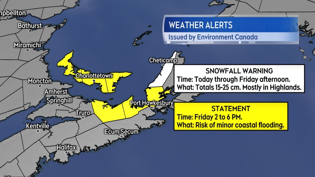
Those areas are under a special weather statement for the period of time between 2 p.m. and 6 p.m. Friday. The statement cautions that “storm surge and minor coastal flooding is possible along shorelines exposed to the north, especially around high tide.” High tide times are available through a number of sources including the Government of Canada website.
The wind is expected to diminish Friday night into Saturday morning. Water levels will also subside through that same period.
More flurries
Cloudy periods and scattered flurries are expected in the Maritimes Thursday night.
Flurries persist for parts of the region Friday. Areas most likely to see flurries on Friday include southeastern New Brunswick, Prince Edward Island, and northern/eastern areas of Nova Scotia. Snow amounts of trace or one-to-five centimetres locally.
Snow remains steadier in the western part of the Cape Breton Highlands. Northern Inverness County remains under a snowfall warning with additional snow amounts at the higher elevations of 15-to-25 centimetres. A weather station located at North Mountain in the Highlands has recorded 87 new centimetres of snow on the ground since Sunday.
 A snowfall warning continues for the Cape Breton Highlands. Statements cautioning on higher than normal coastal water levels Friday are in place for Prince Edward Island and Pictou, Antigonish, and Inverness counties of Nova Scotia.
Chilly but not cold
The stalled low near Newfoundland has wrapped air from the North Atlantic into the Maritimes. That air is damp and chilly but lacks the biting cold of air that arrives from the polar region. Day time high temperatures continue a few degrees above averages for early January and nighttime lows several degrees above average.
The current temperature regime lingers through early next week. There is some long-range forecast guidance that points to colder, continental air breaking back into the Maritimes late next week.
CTVNews.ca Top Stories

Thousands of structures destroyed in L.A. County's most destructive fire
A series of wildfires tore through densely populated parts of the Los Angeles, Calif. area. Five people have been reported dead. U.S. Gov. Gavin Newsom said thousands of resources have been deployed to contain the fires.
Is the Hollywood sign on fire?
As fires scorch Los Angeles, fake images and videos of a burning Hollywood sign have circulated on social media.
U.S. Supreme Court rejects Trump's bid to delay sentencing in his New York hush money case
A sharply divided U.S. Supreme Court on Thursday rejected president-elect Donald Trump's final bid to put his New York hush-money case on hold, clearing the way for him to be sentenced for felony crimes days before he returns to the presidency.
Ex-Trump adviser says Canada in 'difficult position' amid tariff threat, Trudeau resignation
In the face of a potential tariff war, U.S. president-elect Donald Trump's former national security adviser John Bolton says 'Canada is in a difficult position' in part due to Prime Minister Justin Trudeau's resignation and a looming general election.
PM Trudeau says he thinks Trump is using talk of Canada becoming 51st state to distract from tariff impact
Prime Minister Justin Trudeau says he thinks U.S. president-elect Donald Trump is drumming up drama on Canadian statehood to detract from tariff talks.
Canadian travellers now require an ETA to enter U.K. Here's what to know
Starting Jan. 8, Canadians visiting the U.K. for short trips will need to secure an Electronic Travel Authorization (ETA) before boarding their flight, according to regulations set out by the U.K. government.
'True when I said it, true today': former Canadian PM Harper pushes back against Trump on social media
Former prime minister Stephen Harper doesn’t find U.S. president-elect Donald Trump’s jibes about Canada becoming the 51st U.S. state very amusing.
Poilievre says the next Canadian election will be about the carbon price
Pierre Poilievre returned to Ottawa on Thursday after the holidays with a familiar demand for Justin Trudeau: call a carbon-tax election.
More than 150 students sick at University of Guelph, says public health
More than 150 cases of gastroenteritis have been reported at the University of Guelph.


