Snow forecast for Tuesday night; more expected Thursday into Friday
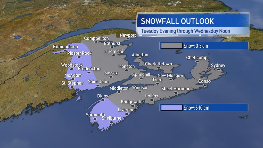
A trough of low pressure will bring in a round of snow to western parts of the Maritimes Tuesday night into Wednesday morning.
Some totals of 5 to 10 cm are possible in the western half of New Brunswick and the southwest of Nova Scotia. For the remainder of the Maritimes, including eastern New Brunswick, Prince Edward Island, and eastern Nova Scotia, as little as trace up to a centimetre or two are expected in much lighter snow or flurries.
However, the next system that follows has more potential for some heavier snow for parts of the region.
 Snow will be steadiest in western areas of New Brunswick and the southwest of Nova Scotia Tuesday night.
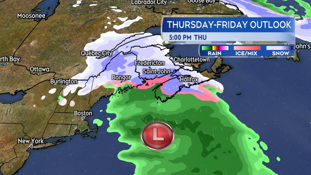
It’s another low-pressure system moving out of the northeastern United States. Once again, the track of the low is expected to take it south and then east of the Maritimes. Despite the centre of the system remaining to the region's south, it comes close enough and is large enough to wrap in snow.
There remains a degree of uncertainty as to where in the Maritimes the heaviest band of snow is going to be. The uncertainty is a result of variation in how close the low-pressure centre will get to the southwest of Nova Scotia as it passes.
If closer, the heavier snow will be pushed up towards southern New Brunswick, P.E.I., and eastern Nova Scotia. If further away, the heavier snow slips down into central Nova Scotia.
 Snow, except some rain for the southwest of Nova Scotia, develop Thursday afternoon into evening.
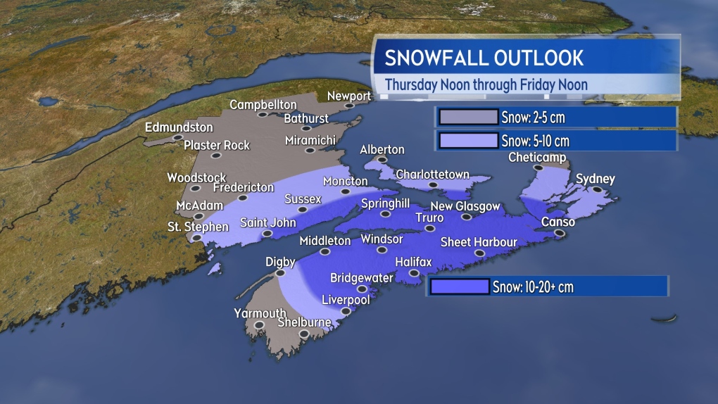
Putting aside that uncertainty, the area of the Maritimes that looks most likely to see some snow amounts of 10 to 20 cm includes parts of southern New Brunswick, southeastern P.E.I., just over the Canso Causeway in Cape Breton, and then across much of mainland Nova Scotia.
The exception in mainland Nova Scotia will be the southwestern corner of the province where rain mixing in will limit the snow. It is possible that within that area of 10 to 20 cm there could be a pocket of 20 to 30 cm totals. The possible location of that pocket of even higher amounts ranges from near the north shore of Nova Scotia to as far south as Liverpool in weather model guidance available.
The hope is that a better consensus for the track of the system, and hence a better consensus for the location of that heavier snow, will emerge over the next 24 hours.
 While a degree of uncertainty remains as to how much falls where, heavier snow is possible for parts of the Maritimes Thursday into Friday.
As for timing, snow will develop Thursday afternoon into evening, with a mix of rain and snow in southwestern Nova Scotia.
The heavier snow is expected Thursday evening and night. By early Friday morning, the steadier snow will be clearing to the east. Flurries may linger for P.E.I. and eastern Nova Scotia into early Friday afternoon.
CTVNews.ca Top Stories

NEW Federal Liberals to pick new leader on March 9 as rules for leadership race are defined
The Liberal Party of Canada have announced leadership race rules late Thursday, including a significant increase in entrance fees and a requirement for voters to be Canadian citizens.
Liberals will remove 'fraudulent' memberships, as some register their pets to vote
A federal Liberal spokesman says the party can and will remove "fraudulent profiles" from its list of electors eligible to vote for its next leader.
Provincial health plans to cover primary care by nurse practitioners: health minister
Federal Health Minister Mark Holland says provincial and territorial health plans will cover primary care provided by nurse practitioners, pharmacists and midwives.
Canadian 'Super Scooper' plane grounded after hitting civilian drone over Los Angeles wildfires
A Canadian “Super Scooper” aircraft fighting the Palisades Fire in Los Angeles had to be grounded after it hit a drone flying in restricted airspace over the devastating blaze on Thursday, the local fire department said.
NEW Five ways homeowners can protect themselves from contractor fraud
Building or renovating a home can be one of the biggest expenses of one's life. It's costly, and potentially even more expensive if something goes wrong. Between 2022-24, the Better Business Bureau (BBB) received hundreds of complaints about general contractors in Canada.
Earth records hottest year ever in 2024 and the jump was so big it breached a key threshold
Earth recorded its hottest year ever in 2024, with such a big jump that the planet temporarily passed a major climate threshold, several weather monitoring agencies announced Friday.
US$1-billion Dubai skyscrapers to be linked by daring rooftop pool
Two new 591-foot-tall skyscrapers, linked across the top by a daring “sky pool,” are set to rise above Dubai’s Marasi Marina.
NEW Why four Canadians traded their traditional office space for a life on the road
CTVNews.ca asked Canadians who've embraced the digital nomad lifestyle, or have done so in the past, to share their stories — the challenges, triumphs and everything in between.
Winds that have fueled LA fires are expected to calm, giving firefighters a chance to corral flames
Firefighters hoped for a break Friday from fierce winds that have fueled massive blazes in the Los Angeles area, killing 10 people, obliterating whole neighborhoods and setting the nation's second-largest city on edge.


