Snow swipes southwestern area of Maritimes Thursday, more snow expected Friday

Two low pressure systems will exit the northeastern United States and pass to the south of the Maritimes through the end of this week.
With colder air in place, some snow and flurries are expected in the region.
For both Thursday and Friday, the steadiest snow is most likely in the southwestern areas.
THURSDAY SNOW
Snow is anticipated to start falling Yarmouth and Shelburne counties of southwestern Nova Scotia near 2 a.m. Thursday.
By 8 a.m., the snow will have moved up the South Shore of Nova Scotia towards Halifax. By this time, snowfall will have started in the Annapolis Valley, and be falling in parts of the southwest of New Brunswick.
The snow will be light for most, though a bit steadier in the southwest of Nova Scotia, where Yarmouth and Shelburne counties could finish with some totals of 10 to 15 centimetres.
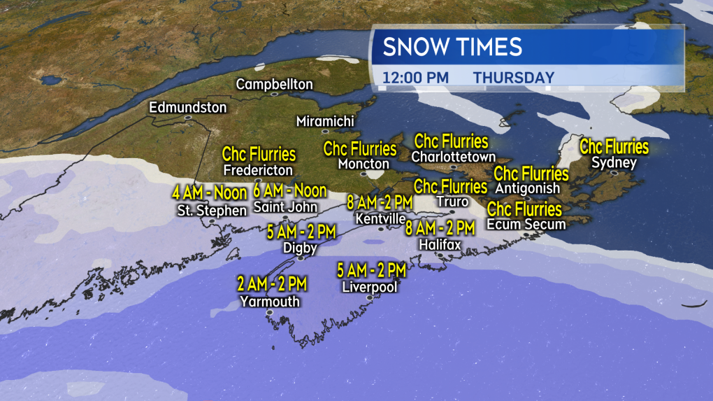 A morning into afternoon snowfall for parts of southwestern New Brunswick and southwestern Nova Scotia on Thursday.
By early afternoon, the snow will have eased to a chance of flurries.
Not much more than a low chance of flurries on Thursday for northern and eastern areas of New Brunswick, Prince Edward Island, and much of the eastern half of Nova Scotia, including Cape Breton.
Wind on Thursday will be out of the north and northeast and sustained between 10 to 20 km/h, with gusts as high as 20 to 40 km/h. It shouldn’t cause much in the way of issues. Some extra caution warranted in the southwestern corner of Nova Scotia where the snow will be steadier, increasing the chances of reduced visibility in drifting snow.
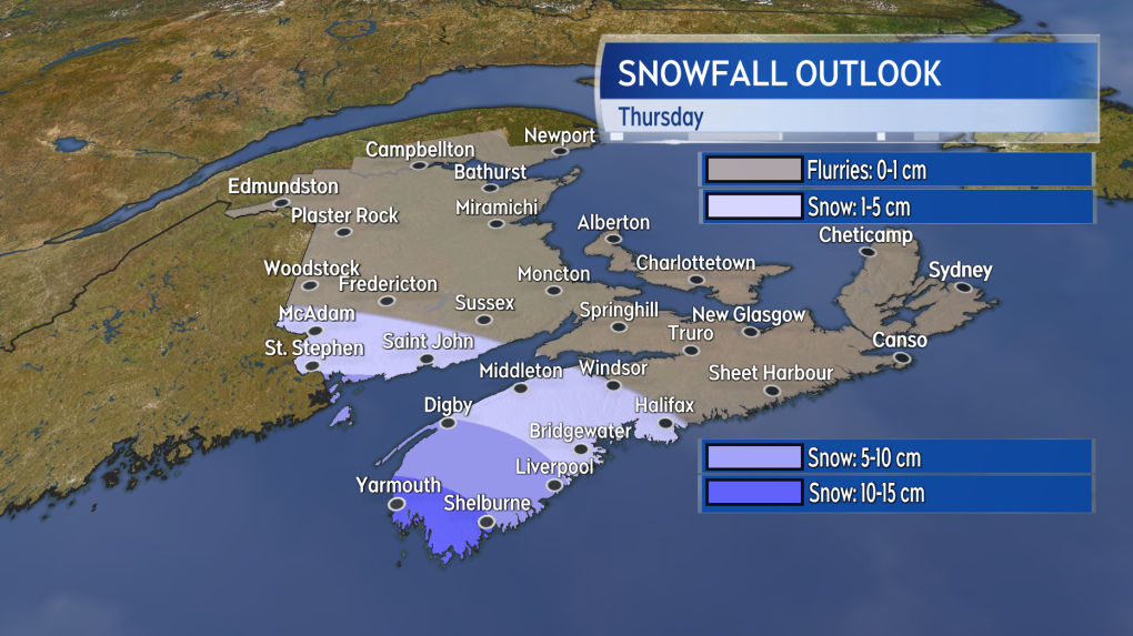 While generally 5 centimetres or less is expected, the southernmost areas of Nova Scotia could pick up 10 to 15 centimetres of snow.
FRIDAY SNOW
The Friday low pressure system is a bit larger, stronger, and passes closer to the Maritimes. That means Friday is likely to see accumulating snow in a more widespread capacity in the Maritimes. Once again though, the steadiest of that snowfall will be towards the southwest of New Brunswick and for parts of western Nova Scotia.
That round of snow starts around midnight Friday for western areas of New Brunswick and the southwest of Nova Scotia.
By 8 a.m. Friday, snow should be falling across most of the Maritimes, though it will be light in northern New Brunswick, Prince Edward Island, and eastern Nova Scotia. Friday afternoon will see the snow ease to a chance of flurries for New Brunswick, Prince Edward Island and Cape Breton, with snow easing to a chance of flurries Friday evening for mainland Nova Scotia.
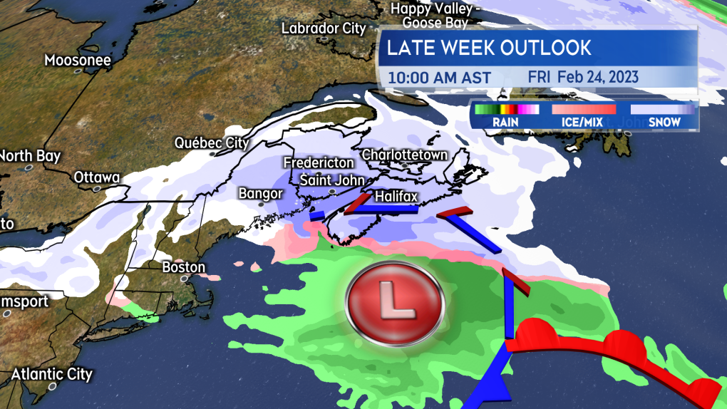 The Friday low pressure system passes closer to the Maritimes. Snow is expected to be more widespread in the region.
The best shot at some Friday totals of 10 to 15 centimetres will be the southwestern corner of New Brunswick, Halifax and west for Nova Scotia. Central areas of New Brunswick and the remainder of mainland Nova Scotia should generally see 5 to 10 centimetres of snow. Snowfall of mostly less than 5 centimetres is expected in northern New Brunswick, Prince Edward Island, and much of Cape Breton, though the Highlands could climb into the 5 to 10 centimetres range.
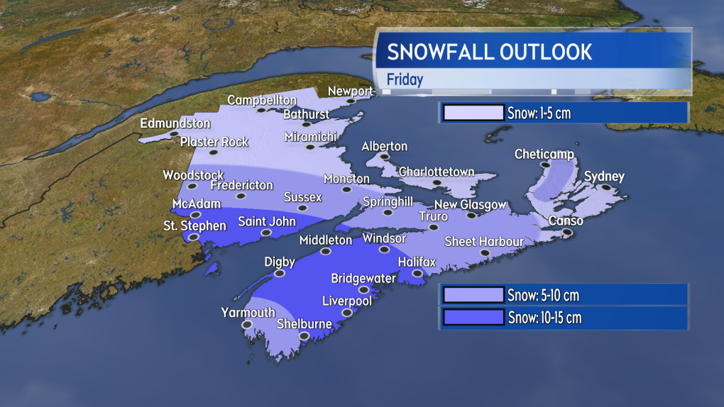 A 5 to 10 centimetres snowfall for a larger area of the Maritimes compared to Thursday. Some totals of 10 to 15 centimetres are possible in parts of southern New Brunswick and western Nova Scotia.
The north and northeast wind will increase in strength for Friday. Gusts could reach 40 to 60 km/h in southern areas of New Brunswick and Nova Scotia. The gustier conditions will likely get the falling snow blowing around. Periods of reduced visibility in the falling snow should be expected Friday morning and afternoon.
Updates and snow timelines on CTV News Atlantic at 5, 6, and 11:30 p.m.
CTVNews.ca Top Stories

Walking pneumonia is surging in Canada. Is it peaking now?
CTVNews.ca spoke with various medical experts to find out the latest situation with the typically mild walking pneumonia in their area and whether parents should be worried.
Minister calls GST holiday, $250 cheques for 18 million Canadians 'a targeted approach'
Women and Gender Equality and Youth Minister Marci Ien is calling the federal government's proposed GST holiday and $250 rebate cheques a 'targeted approach' to address affordability concerns.
'Her shoe got sucked into the escalator': Toronto family warns of potential risk of wearing Crocs
A Toronto family is speaking out after their 10-year-old daughter's Crocs got stuck in an escalator, ripping the entire toe area of the clog off.
Ancient meets modern as a new subway in Greece showcases archeological treasures
Greece's second largest city, Thessaloniki, is getting a brand new subway system that will showcase archeological discoveries made during construction that held up the project for decades.
Quebec man, 81, gets prison sentence after admitting to killing wife with Alzheimer's disease
An 81-year-old Quebec man has been sentenced to prison after admitting to killing his wife with Alzheimer's disease.
Canada Post quarterly loss tops $300M as strike hits second week -- and rivals step in
Canada Post saw hundreds of millions of dollars drain out of its coffers last quarter, due largely to its dwindling share of the parcels market, while an ongoing strike continues to batter its bottom line.
'Immoral depravity': Two men convicted in case of frozen migrant family in Manitoba
A jury has found two men guilty on human smuggling charges in a case where a family from India froze to death in Manitoba while trying to walk across the Canada-U.S. border.
Prime Minister Trudeau attends Taylor Swift's Eras Tour in Toronto with family
Prime Minister Justin Trudeau is a Swiftie. His office confirmed to CTV News Toronto that he and members of his family are attending the penultimate show of Taylor Swift's 'The Eras Tour' in Toronto on Friday evening.
Trump supporters review-bomb B.C. floral shop by accident
A small business owner from B.C.'s Fraser Valley is speaking out after being review-bombed by confused supporters of U.S. president-elect Donald Trump this week.


