Warnings expand as Hurricane Lee brings widespread impacts to the Maritimes this weekend
There has been a slight movement east of the forecast track, and a slight increase in speed towards the north, for Hurricane Lee on Friday.
Neither of those adjustments will significantly change the weather impacts the Maritimes is facing this weekend. The landfall of the centre of the storm looking likely to be in Yarmouth County, Nova Scotia, and between Saturday 3 p.m. to 6 p.m. It is still possible the centre passes just offshore of the southwest of Nova Scotia, in which case it would make landfall on the Bay of Fundy coastline in New Brunswick near Saint John Saturday night.
Lee is a very large storm system in size. Impactful wind, rain, and winds well spread out from the centre. Much of the Maritimes will be into inclement weather well before the centre starts to near.
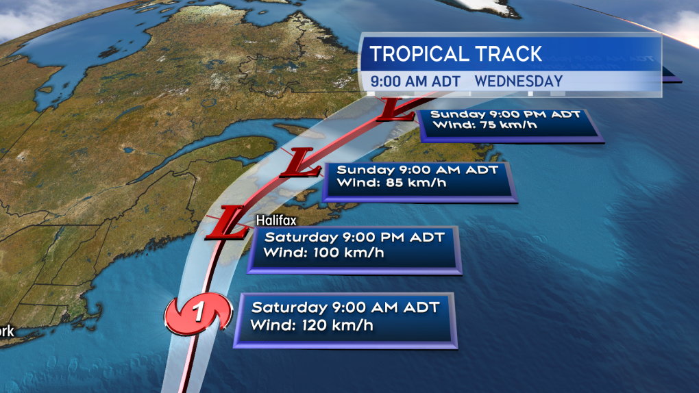 The path of Lee narrowing towards a potential landfall in Yarmouth County, Nova Scotia, late Saturday afternoon into evening.
NEW BRUNSWICK
A hurricane watch cautioning of wind gusts that could reach 120 km/h for exposed areas on Saturday remains in effect for Grand Manan and Coastal Charlotte County. A tropical storm warning extends along the Bay of Fundy coastline and into Moncton and the southeast calling for a risk of winds reaching 70 km/h or more. A wind warning is in place for Coastal Charlotte County and Saint John and the Fundy coast that calls for northeast wind gusts of 80 to 100 km/h on Saturday. A rainfall warning for 50 to 100 mm of rain extends across the southern half of New Brunswick.
Areas outside of the tropical storm and wind warnings could also peak with gusts of 60 to 80 km/h on Saturday. While the risk of power outages is highest in the southwest and along the Bay of Fundy coastline, outages could happen outside those areas as well.
Some of the highest rain totals with Lee are expected in New Brunswick. By early Sunday morning a broad band of totals 60 to 120 mm is possible, running southwest to northeast across the province. Rain totals that high in 24 hours come with a risk of flooding and flash flooding.
The coastlines of New Brunswick, including the Bay of Fundy and east coast, will be at risk of elevated water levels and pounding waves. High tides should be watched in particular. The first high tide of concern will be early afternoon Saturday on the Bay of Fundy coastline. The first high tide of concern will be afternoon through early evening Saturday on the eastern coastline.
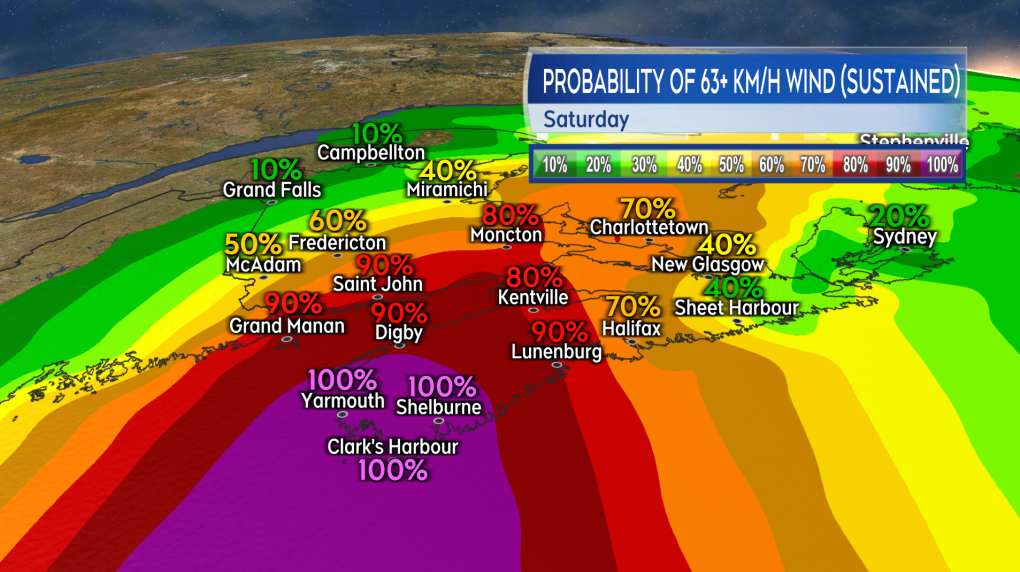 The highest risk of tropical storm-force winds, sustained 63 km/h with stronger gusts, will be in western Nova Scotia and along the Bay of Fundy coastline in New Brunswick.
NOVA SCOTIA
A hurricane watch extends from the Tri-County region of the southwest up the South Shore and across Halifax County. The watch calling for a risk of wind gusts up to 120 km/h on Saturday for exposed areas, particularly along the coastline. A tropical storm warning is in effect for the western half of Nova Scotia as well as Guysborough County. The tropical storm warnings calls for a risk of winds that could approach 70 km/h with stronger gusts. A wind warning is also in effect for most of those areas but also includes Truro and northern Inverness County in Cape Breton. Easterly gusts through those areas could peak between 90 and 110 km/h on Saturday.
Areas outside the tropical storm and wind warnings could still peak with gusts 60 to 80 km/h on Saturday. While the risk of power outages is highest in western Nova Scotia, outages in other areas can’t be ruled out.
A rainfall warning is in effect for the Tri-County area, the Annapolis Valley, and the South Shore of Nova Scotia. The warning calls for rain totals that could reach 50 to 100 mm. There is a risk that heavy downpours could cause flash flooding.
A storm surge warning is now in place for the Atlantic coastline of mainland Nova Scotia. Waves breaking four to six metres upon approach to the coastlines exposed to the open ocean are expected. There is a risk of elevated water levels and coastal flooding during high tides. The first high tide will be from 6 to 10 a.m., with a second high tide 7 to 11 p.m.
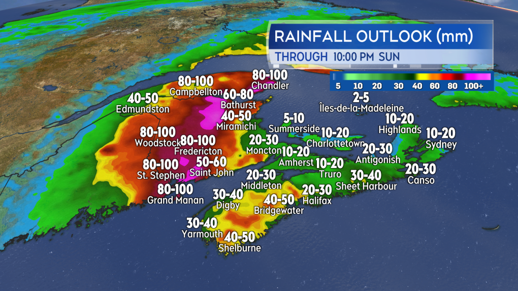 The heaviest rain from Lee will most likely be in western mainland Nova Scotia and then through a large area running southwest to northeast in New Brunswick.
PRINCE EDWARD ISLAND
Prince Edward Island remains under the general Environment Canada statement for Lee. While the province is not under a weather warning at this time, strong wind gusts are still expected on Saturday.
The wind will initially be northeast and eventually turn southeast through the day. Intermittent gusts of 60 to 80 km/h are likely. While the risk of power outages is not as high as in western Nova Scotia and southern New Brunswick it is still there.
Periods of rain are expected to bring totals of 20 to 40 mm with a risk of downpours.
The Canadian Hurricane Centre is noting that wave conditions will become rough in the Gulf of St. Lawrence and the Northumberland Strait, but are expected to remain below warning criteria.
 Intense wave action is expected to develop near the Atlantic coastline of Nova Scotia on Saturday.
SUMMARY
As noted above, the size of the weather system will bring a widespread risk of power outages to the Maritimes. The risk of outages will be highest in western mainland Nova Scotia and along the Bay of Fundy coastline in New Brunswick. Heavy rain and downpours brings a risk of flash flooding into western Nova Scotia and across a large area of New Brunswick. Caution needs to be taken on parts of the coast as large and pounding waves are expected.
The worst of the weather will be on Saturday, with most of the Maritimes seeing conditions deteriorate morning through afternoon. Wind gusts of 50 to 70 km/h linger into Sunday morning as wind changes direction to become west and southwest. Rain will have eased to showers. A further slow improvement of weather conditions is expected Sunday afternoon through evening.
Please take the time to check in on the details of any weather warnings that are in effect for your area.
CTVNewsAtlantic.ca will provide coverage and live updates on Hurricane Lee, every hour on the hour, beginning at 8 a.m. Saturday.
Shopping Trends
The Shopping Trends team is independent of the journalists at CTV News. We may earn a commission when you use our links to shop. Read about us.


CTVNews.ca Top Stories

BREAKING
BREAKING PM Trudeau says he thinks Trump is using talk of Canada becoming 51st state to distract from tariff impact
Prime Minister Justin Trudeau says he thinks U.S. president-elect Donald Trump is drumming up drama on Canadian statehood to detract from tariff talks.
LIVE UPDATES
LIVE UPDATES Here's the latest on the most destructive fire in L.A. County history
A series of wildfires are tearing through densely populated parts of the Los Angeles, Calif. area. Five people have been reported dead. U.S. Gov. Gavin Newsom says thousands of resources have been deployed to contain the fires.
More than 150 students sick at University of Guelph, says public health
More than 150 cases of gastroenteritis have been reported at the University of Guelph.
Multiple Chinese warships track Canadian HMCS Ottawa through the South China Sea
The silhouettes of a hulking Chinese Navy destroyer dubbed 'Changsha' and a warship called the 'Yuncheng' can been seen hovering along the horizon, mirroring HMCS Ottawa’s movements.
Canadian travellers now require an ETA to enter U.K. Here's what to know
Starting Jan. 8, Canadians visiting the U.K. for short trips will need to secure an Electronic Travel Authorization (ETA) before boarding their flight, according to regulations set out by the U.K. government.
'True when I said it, true today': former Canadian PM Harper pushes back against Trump on social media
Former prime minister Stephen Harper doesn’t find U.S. president-elect Donald Trump’s jibes about Canada becoming the 51st U.S. state very amusing.
Toronto police investigating parental abduction, three-year-old boy believed to be in India
A parental abduction investigation is underway after a father allegedly failed to return to Canada with his three-year-old son after a trip to India, Toronto police say.
California's insurance is in crisis. The solution will cost homeowners a ton
Lynne Levin-Guzman stood in the front yard of her 90-year-old parents’ home in Los Angeles County, California, trying to protect it with a garden hose — because their insurance company no longer would.
As wildfires rage in Los Angeles, Trump doesn't offer much sympathy. He's casting blame.
As cataclysmic wildfires rage across Los Angeles, President-elect Donald Trump hasn't been offering much sympathy. Instead, he's claiming he could do a better job managing the crisis, spewing falsehoods and casting blame on the state's Democratic governor.
Toronto
-

Ontario ready to deploy more than 150 firefighters to California, Ford calls situation 'devastating'
More than 150 Ontario firefighters are standing by and ready to be deployed to California as the state battles unprecedented wildfires, which have displaced more than 100,000 residents and left five people dead.
-
Toronto police investigating parental abduction, three-year-old boy believed to be in India
A parental abduction investigation is underway after a father allegedly failed to return to Canada with his three-year-old son after a trip to India, Toronto police say.
-
What parents need to know about the PowerSchool data breach
The attacker behind the data breach impacting several school boards across the Greater Toronto Area and abroad may have gotten access to staff and students' personal and sensitive information, PowerSchool says.
Calgary
-

'Confused and angry': Facebook users call out Meta for failing to remove drug ads
More Facebook users are speaking out, telling CTV News they're being inundated by ads for drugs while accessing the social media site.
-
Southeast Calgary business owner charged with sexual assault of young girl in shop
A 63-year-old man has been charged with the sexual assault of a young girl in a southeast Calgary tailor shop.
-
Fire at LDS church in S.W. Calgary set intentionally: police
Police say a fire at a Church of Jesus Christ of Latter-day Saints in southwest Calgary early on Thursday morning was intentionally set.
Edmonton
-

'Elaborate' solar-powered encampment found in Fulton Creek
Edmonton police have dismantled two large encampments in the Fulton Creek area, including one with electricity.
-
Saskatchewan man sentenced in historical Edmonton sexual assault case
A Saskatchewan man has been sentenced to two-years-less-a-day of house arrest for a sexual assault case that happened in Edmonton more than 40 years ago.
-
26 charges laid in Alberta crash that killed 2 motorcyclists on charity ride
A Slave Lake man is facing more than two dozen charges in connection with a crash that killed two people and injured several others in August.
Montreal
-

Former clown admits to sexually assaulting more victims
A former clown, who worked at children’s parties, has admitted in Quebec Superior Court to having more sexual assault victims.
-
Parti Quebecois leader calls on Premier Legault to create ‘Team Quebec’ in face of tariff threat
Paul St-Pierre Plamondon is calling on Francois Legault to create a 'Team Quebec' (Équipe Québec) comprising the opposition parties, academics and organizations to deal with the tariff threats made by U.S. President-elect Donald Trump.
-
Lawsuit against Mike Ward: Supreme Court dismisses Sylvie Gabriel's application
The Supreme Court of Canada has put an end to attempts by Sylvie Gabriel, the mother of Jeremy Gabriel, to obtain compensation from comedian Mike Ward.
Ottawa
-

'It's really horrific': Former Ottawa residents in LA evacuated due to fires
Feeling the power of the Santa Ana winds and seeing the massive plumes of smoke off her deck in Topanga Canyon earlier this week, Catherine McClenahan knew it was time to go.
-
Crash involving bicycle in Centretown seriously injures man
The Ottawa Paramedic Service says an adult male was taken to hospital following a collision between a vehicle and a bicycle Thursday afternoon in Centretown.
-
Rideau Canal Skateway to open on Saturday
The National Capital Commission announced 3.6 kilometres of the Rideau Canal Skateway will open to the public at 8 a.m. on Saturday.
London
-

Woman suspected in north end assault: LPS
On Sunday, Dec. 22, at roughly 8:20 p.m., a woman leaving a business in the area of Fanshawe Park Road East and North Centre Road was assaulted by an unknown woman.
-
Londoner charged following head-on collision
One person has been charged by Elgin County OPP after a collision occurred Wednesday morning.
-
Industrial fire closes road for 12 hours
No injuries have been reported in an industrial fire that caused road closures in Petrolia on Wednesday.
Barrie
-

Snow squalls blanket Clearview Township, keeping crews and residents busy
Unrelenting snow squalls kept residents and road crews in Clearview Township on their toes Thursday, including one CTV News reporter.
-
OPP officer charged with assault expected to plead guilty
A month before what was supposed to be the start of his trial in Huntsville, Const. Scott Anthony, the suspended Bracebridge OPP officer charged with assaulting a man during an arrest in July 2022 in MacTier, is expected to plead guilty, according to his legal counsel.
-
Students evacuated during Barrie high school fire
A small fire in a high school washroom disrupted classes Thursday.
Northern Ontario
-

Alta. man charged and released twice in one night for violence at northern Ont. hotel
Last weekend, an Alberta man was arrested and released for intimate partner violence at a northern Ontario hotel just hours after being charged and released for assaulting a teen with a weapon at the same location.
-
Former Sudbury, Ont., police officer found guilty of 2007 sexual assault
Wayne Foster, a former police officer with the Greater Sudbury Police Service, has been found guilty of sexual assault in connection with an incident Aug. 24, 2007.
-
Man tried to run over dog with a vehicle, northern Ont. police say
A suspended driver who was on probation is accused of trying to harm a dog with a vehicle in Thessalon First Nation in northern Ontario.
Kitchener
-

More than 150 students sick at University of Guelph, says public health
More than 150 cases of gastroenteritis have been reported at the University of Guelph.
-
City of Guelph mourns staff member struck by bus
The City of Guelph is mourning the death of a city staff member after he was struck by a bus Wednesday afternoon.
-
Jury selected for trial of man accused of killing his father in Guelph
The jury has been selected for the trial of a man accused of killing his father in Guelph, nearly two years ago.
Windsor
-

Sentencing date set for Windsor man convicted of careless driving in fatal Retrofest collision
A sentencing date has been set for a Windsor man convicted of careless driving in a fatal Retrofest collision.
-
Teen charged with assault after allegedly spraying bear mace
An 18-year-old man has been charged with assault after he allegedly bear maced someone during an argument in east Windsor.
-
Map: Windsor road closures for the Detroit Lions Drone Show
Some Windsor downtown roads will be closed during the Detroit Lions Drone Show at the riverfront Friday night.
Winnipeg
-

Winnipeg man charged with sexually assaulting children at daycare: police
Police have charged a man with sexually assaulting two children at an unlicensed daycare in Winnipeg.
-
'A policing trailblazer': Tributes pour in for MFNPS chief believed to have died in house fire
The remains of Manitoba First Nations Police Service’s (MFNPS) leader are believed to have been found following a fire at his home.
-
'Really unique': Ice core drilled by U of M scientist could unlock climate history
A Manitoba researcher was part of a historic research team that uncovered the oldest ice core ever retrieved.
Regina
-

Sask. taxidermy business fined more than $7,000, 144 'wildlife exhibits' seized
What began as a "straightforward" inspection of a Saskatchewan taxidermy business quickly became a complex investigation – ultimately leading to more than $7,000 in fines.
-
Sask. ministry says it mailed more than 400 T4A tax slips to the wrong address
Saskatchewan's Ministry of Advanced Education says 415 T4A tax slips were mistakenly sent to wrong addresses after errors with an electronic spreadsheet.
-
Roughriders sign newly acquired QB Jake Maier
The Saskatchewan Roughriders announced they have signed quarterback Jake Maier, who they acquired via trade with the Calgary Stampeders in December.
Saskatoon
-

Saskatoon restauranteur George Kosmas looks back on a life spent in The Cave
For nearly his entire life, George Kosmas can remember spending days and nights at The Cave.
-
'They are hopeless': Saskatoon family desperate to bring sisters to Canada
Two Saskatoon women are desperately trying to get their loved ones out of Afghanistan, as the Taliban continues to oppress women.
-
Saskatchewan RCMP investigating serious highway crash
The Saskatchewan RCMP is investigating a serious collision on Highway 14, east of Biggar.
Vancouver
-

B.C. teen with avian flu discharged after weeks in hospital
BC Children’s Hospital says a 13-year-old girl with avian flu was discharged Tuesday after weeks in hospital.
-
Art shows, comics and a tea party: Events to check out in Metro Vancouver this weekend
The second weekend of 2025 is here, and it brings with it a variety of new beginnings, including the buildup to Lunar New Year. Here are some events you may want to check out.
-
Reported firearm at B.C. high school was actually a stick: RCMP
A firearms report that triggered a large police presence at a high school on Vancouver Island Thursday turned out to be a prop students were using for a project, according to authorities.
Vancouver Island
-
B.C. teen with avian flu discharged after weeks in hospital
BC Children’s Hospital says a 13-year-old girl with avian flu was discharged Tuesday after weeks in hospital.
-
Reported firearm at B.C. high school was actually a stick: RCMP
A firearms report that triggered a large police presence at a high school on Vancouver Island Thursday turned out to be a prop students were using for a project, according to authorities.
-
RCMP seek man accused in violent purse-snatching in Nanaimo, B.C.
Mounties on Vancouver Island say a warrant has been issued for the arrest of a 39-year-old man who is accused of a violent purse-snatching incident late last year.
Kelowna
-

1 hospitalized, residents displaced after Kelowna apartment fire
Firefighters knocked down a blaze on the third floor of a low-rise apartment building near downtown Kelowna Monday afternoon.
-
Lost skiers rescued off B.C. mountain
Search and rescue volunteers in B.C.’s Okanagan successfully reunited two skiers with their family Friday evening.
-
Charges laid after child porn investigation that 'spanned several different countries,' Kelowna RCMP say
Police in Kelowna say an international investigation has led to child pornography charges against a 46-year-old man.


