Weather front brings heavy rain, power outages to the Maritimes
A weather front off a low-pressure system centred over the border of Ontario and Quebec has brought downpours and winds to the Maritimes gusty enough to create some power outages.
New Brunswick was the province most affected by Monday's power outages. Just after noon, NB Power was reporting near 46,000 affected customers. Nova Scotia Power was near 500 affected customers, while Maritime Electric on Prince Edward Island had eight reported outages.
The wind has primarily been from the east, with gusts ranging 30 to 60 km/h for most. Stronger wind gusts are present on the Atlantic coastline of Nova Scotia where they have approached 80 km/h. A wind warning has been issued for northern Inverness County, Cape Breton, for gusts that could peak near, or in excess of, 110 km/h Monday afternoon into Tuesday morning. The stronger winds for that part of the Maritimes is due to the topography of the Cape Breton Highlands.
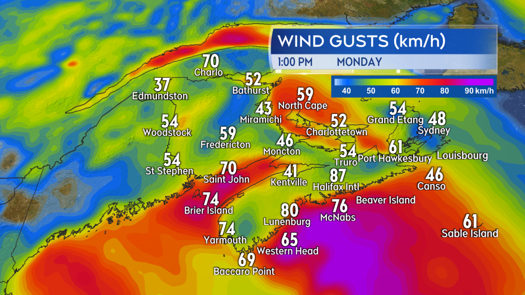 Peak winds gusts reported across weather stations in the Maritimes as of just after 1 p.m. Monday.Southwestern New Brunswick and southwestern Nova Scotia cleared the heaviest rain early Monday afternoon. Those areas reported general totals of 10 to 30 mm with some higher local amounts of 30 to 50 mm reported in Nova Scotia. The South Shore and western Halifax County are under a rainfall warning that calls for some totals to approach 50 mm.
The rain will clear New Brunswick and western Nova Scotia Monday afternoon and evening. Periods of rain will linger for Prince Edward Island and eastern Nova Scotia Monday night and Tuesday. The remainder of the Maritimes will have a chance of showers or drizzle on Tuesday. The sun may break through a bit Tuesday in western areas of New Brunswick and southwestern Nova Scotia.
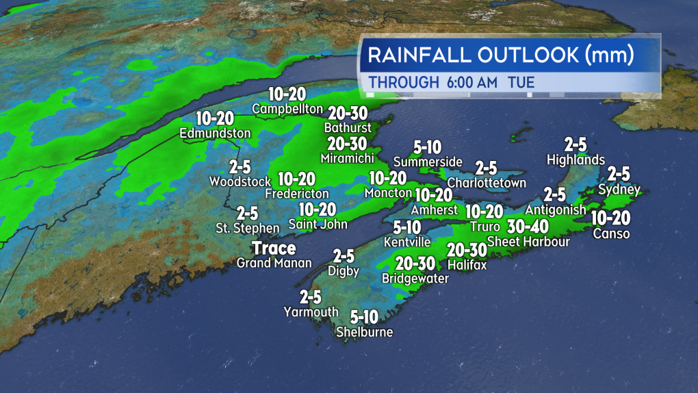 Additional rain amounts expected Monday afternoon through Tuesday morning. Further periods of rain are expected for eastern Nova Scotia and P.E.I. on Tuesday.Another low-pressure system moving out of the northeastern United States will pass south and east of the Maritimes on Wednesday. While not coming directly through, that will keep us in a general northeast wind off the North Atlantic. That chilly, moisture-laden band of ocean air will keep showers and drizzle in place for the Maritimes on Wednesday. Some wet snow may mix in with showers for Cape Breton. High temperatures will be held in the single digits, which is well below the averages for early May, which are in the low-to-mid teens.
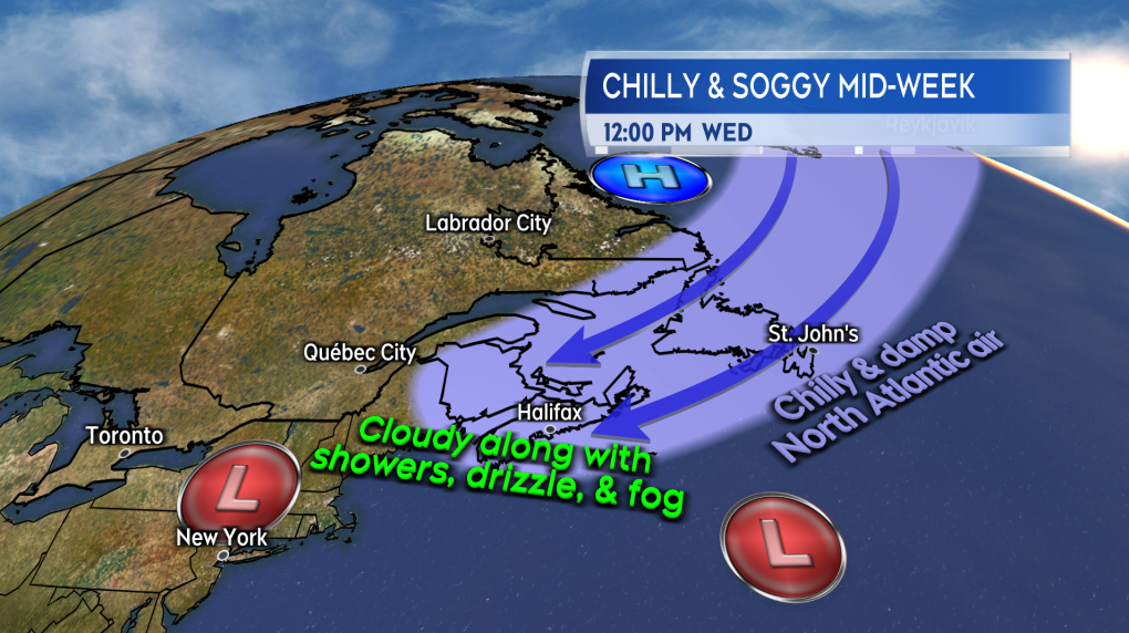 North Atlantic air will keep showers, drizzle, and fog around the Maritimes on Wednesday, with chilly May temperatures as well.Cooler, cloudier weather with a chance of showers are expected to persist through the end of the week. Don’t to get too down about the damp conditions though, as we did run a deficit for rain through March and April. This week’s weather should help the fire weather index in the region in particular, which was starting to creep up a bit in some areas.
Watch forecast updates and regional weather conditions on CTV News Atlantic Five, Six, and 11:30 p.m.
Shopping Trends
The Shopping Trends team is independent of the journalists at CTV News. We may earn a commission when you use our links to shop. Read about us.


CTVNews.ca Top Stories

Trudeau, Carney push back over Trump's ongoing 51st state comments
Two senior members of the federal cabinet were in Florida Friday pushing Canada's new border plan with Donald Trump's transition team, a day after Trudeau himself appeared to finally push back at the president-elect over his social media posts about turning Canada into the 51st state.
Calgary Boxing Day crash victim identified, mother and sister still in hospital
A nine-year-old girl has died in hospital after the vehicle she was in was struck by a driver in a stolen vehicle fleeing from police.
Missing dog returned to family home and rang the doorbell
After a nearly weeklong search, Athena, a four-year-old German Shepherd and Husky mix, found her way home to her Florida family in time for Christmas Eve and even rang the doorbell.
Five southern Ont. hunters fined $37K for moose hunt offences in northern Ont.
A multi-year moose hunting investigation resulted in five people being convicted of moose hunting offences and fined a total of $37,000, plus $9,250 in victim surcharges.
Gerry Butts says Trudeau less likely to remain leader since Freeland quit
A former chief adviser and close friend to Prime Minister Justin Trudeau says he doesn't think Trudeau will stay on to lead the Liberals in the next election.
'Home Alone' director Chris Columbus explains how the McCallisters were able to afford that house
Audiences have wondered for years how the family in 'Home Alone' was able to afford their beautiful Chicago-area home and now we know.
Trump says Microsoft's Bill Gates has asked to visit him in Florida
Donald Trump said Microsoft co-founder Bill Gates has asked to visit him at the president-elect's Mar-a-Lago home in Florida on Friday night.
B.C. man charged with dangerous driving after elderly Good Samaritan killed in crash
A man is facing multiple charges of dangerous driving following a collision that led to the death of an 80-year-old Good Samaritan on Vancouver Island, B.C.
Halifax Thunderbirds player Tyson Bell suspended, cited for assault in Colorado
The Halifax Thunderbirds has suspended player Tyson Bell following an alleged assault in Colorado.
Toronto
-

Pedestrian taken to the hospital after being struck by TTC bus driver at Islington Station
A female pedestrian was taken to the hospital after being hit by the driver of a TTC bus on Friday afternoon, say paramedics.
-
1 arrested, one outstanding after armed robbery at Ancaster cannabis dispensary
Police in Hamilton are looking for a man wanted in connection with an armed robbery at a cannabis dispensary in Ancaster.
-
Toronto will see temps above-zero as New Year's Eve approaches, says Environment Canada
The final few days of 2024 will be mild in Toronto, Environment Canada says.
Calgary
-

Calgary Boxing Day crash victim identified, mother and sister still in hospital
A nine-year-old girl has died in hospital after the vehicle she was in was struck by a driver in a stolen vehicle fleeing from police.
-
Calgary woman killed in Saskatchewan highway crash
A 25-year-old woman from Calgary was killed in a crash on Highway 7, west of Rosetown, Saskatchewan on Christmas Eve.
-
Albertans watching closely as Ottawa tries to talk down Trump tariffs
Alberta's politicians and business community will have eyes on Florida this weekend, following a federal government outreach trip.
Edmonton
-

'She's very good at politics': Analyst says Alberta's 2024 bills designed for Smith leadership success
For one political expert, 2024 was all about the base in Alberta.
-
Cell phone scam costs Edmontonians $600K: EPS
Edmonton police are warning residents about a cell phone scam that has so far defrauded victims of more than $600,000.
-
2 teens hospitalized in Christmas Day fire
Two teens were hospitalized after a fire broke out at an apartment building in west Edmonton Christmas Day.
Montreal
-

Montreal SPCA at full capacity amid spike in pet surrenders
The holiday season is typically a slow period for the Montreal SPCA, but this year is different. The animal shelter says the tough economic climate has taken a toll on its operation, leaving it at full capacity.
-
Tugboats, crews try to refloat ship stuck in St. Lawrence River near Montreal
A team of tugboats is being deployed to refloat a ship that has been stuck in the St. Lawrence River northeast of Montreal since Christmas Eve.
-
Avian flu cases are concerning Quebec health officials
Avian flu is raising red flags across several provinces, including in Quebec. While it poses a low risk to humans right now, experts are concerned that could change.
Ottawa
-
 FREEZING RAIN WARNING
FREEZING RAIN WARNING Freezing rain expected in Ottawa Saturday morning ahead of warm spell
After some cold days and nights this past week, warmer weather is on the way.
-
Police watchdog investigating after officer shot crowd control gun at Ottawa man
Ontario’s police watchdog is investigating after an Ottawa police officer shot a crowd control gun at a man, 43, Tuesday in Nepean.
-
Seeking solutions to the troubles facing downtown Ottawa
Rideau Street was once the heart of the capital's shopping district. For decades, people came from all over the region to shop, but with changing habits and the recent revolution in online shopping, many no longer head downtown to find that special item.
London
-

Garage fire causes $125,000 in damages near Tillsonburg
A garage was fully involved by the time responders arrived, with heat from the detached building compromising the residence next to it.
-
Carjacking suspects impersonated police, left victim stranded on 401 on Christmas Day: OPP
On Dec. 25 at 9:00 p.m., police received a call to the eastbound lanes of the 401 near the 65 km marker. There the victim was stopped by three people in two suspect vehicles, one with flashing red and blue lights in the windshield.
-
Wortley Village business pillar to rise again as 'homage to what it was'
Residents and merchants are hopeful 2025 will bring good fortune to Wortley Village in the wake of two devastating fires.
Barrie
-

Snowy conditions bring near-perfect start to ski season with thousands of visitors
A snowy December, topped off by a heavy snowfall just before Christmas, delivered nearly perfect conditions for ski resorts across central Ontario during one of their busiest weeks of the year.
-
'No excuse,' Driver caught speeding 160km/h in posted 80 zone: OPP
Provincial police issued a reminder to motorists to slow down after a driver was stopped for allegedly travelling double the posted speed limit though Kawartha Lakes on Friday afternoon.
-
Are your bins still at the curb? Here are the changes to curbside collection
Curbside collection is delayed by one day this week due to the holidays.
Northern Ontario
-

Five southern Ont. hunters fined $37K for moose hunt offences in northern Ont.
A multi-year moose hunting investigation resulted in five people being convicted of moose hunting offences and fined a total of $37,000, plus $9,250 in victim surcharges.
-
Gerry Butts says Trudeau less likely to remain leader since Freeland quit
A former chief adviser and close friend to Prime Minister Justin Trudeau says he doesn't think Trudeau will stay on to lead the Liberals in the next election.
-
Five-vehicle crash closes Hwy. 11 in New Liskeard
A collision involving five vehicles closed Highway 11 in both directions Friday morning between Golf Course Drive in New Liskeard and Highway 66 in Kenogami.
Kitchener
-

Fire rips through former Peter Hay Knife Company building in Cambridge
Emergency responders were called to a fire in Cambridge on Thursday as flames ripped through the building that formerly belonged to the Peter Hay Knife Company.
-
Influx of dogs in need, Waterloo Region dog rescue says
A not-for-profit dog rescue in Waterloo Region is putting out a call for help around the holidays.
-
Guelph Police looking for man as part of fraud investigation
Police in Guelph have released several photos in an attempt to identify a man connected to a fraud investigation.
Windsor
-
 VIDEO
VIDEOVIDEO Vehicle flipped on its roof in west Windsor collision
A dramatic collision on Windsor's west side left one van overturned on its roof earlier this afternoon.
-
Essex residents get second chance for holiday garbage pickup after calendar misprint
Essex residents in the town’s north end will see garbage trucks return Monday, December 30 after a calendar misprint caused confusion about holiday trash collection.
-
Carjacking suspects impersonated police, left victim stranded on 401 on Christmas Day: OPP
On Dec. 25 at 9:00 p.m., police received a call to the eastbound lanes of the 401 near the 65 km marker. There the victim was stopped by three people in two suspect vehicles, one with flashing red and blue lights in the windshield.
Winnipeg
-

Downtown Winnipeg a hub for research, baking and milling at Cereals Canada
High above on the tenth floor of a downtown Winnipeg office space, baking bread is a normal routine.
-
Man found dead after skid steer falls through ice: Manitoba RCMP
A 58-year-old man is dead after a skid steer fell through the ice on a Manitoba pond on Christmas Eve.
-
Winnipeg police arrest fifth person in drug trafficking investigation; sixth suspect still at large
The Winnipeg Police Service (WPS) has made a fifth arrest in a drug trafficking investigation but is still searching for a sixth suspect.
Regina
-

'Something that connected us all': For 53 years, Sask. family celebrates holidays with street hockey game
For over 50 years, Stephen Lentzos and his family have celebrated Christmas Day with a street hockey game.
-
Regina police launch homicide investigation after injured man dies at scene
Regina police have launched a homicide investigation following the death of a man found gravely injured Thursday evening.
-
Travel not recommended for parts of Saskatchewan under risk of freezing rain
Travel advisories are in effect for parts of south and central Saskatchewan on Friday, with icy roadways and the risk of freezing rain making for dangerous driving conditions.
Saskatoon
-

Calgary woman killed in Saskatchewan highway crash
A 25-year-old woman from Calgary was killed in a crash on Highway 7, west of Rosetown, Saskatchewan on Christmas Eve.
-
Prince Albert man facing weapons charges after Christmas Day of armed robberies
Police in Prince Albert, Sask, are reporting a harrowing Christmas Day story involving three armed robberies, two suspect chases and the shooting of a taxi driver.
-
Travel not recommended for parts of Saskatchewan under risk of freezing rain
Travel advisories are in effect for parts of south and central Saskatchewan on Friday, with icy roadways and the risk of freezing rain making for dangerous driving conditions.
Vancouver
-

B.C. man who flipped 14 homes in four years is fined $2M for tax evasion
A serial property flipper in British Columbia has been convicted of tax evasion and fined more than $2 million for failing to report nearly $7.5 million in earnings.
-
79-year-old man assaulted on B.C. ferry, Sunshine Coast RCMP say
Mounties on B.C.'s Sunshine Coast are asking anyone who witnessed an assault aboard a Thursday afternoon BC Ferries sailing to contact them.
-
B.C. court orders fraudster who owes $36.7M to pay from retirement funds
The British Columbia Securities Commission says a man behind one of the province's largest investment frauds has been ordered by the B.C. Supreme Court to use two retirement accounts to pay off a multimillion-dollar fine.
Vancouver Island
-

2nd earthquake in 3 days reported off Vancouver Island coast
A 4.0-magnitude earthquake struck off Vancouver Island's west coast early Friday morning, less than 48 hours after a 4.8-magnitude quake in roughly the same location on Christmas Day.
-
79-year-old man assaulted on B.C. ferry, Sunshine Coast RCMP say
Mounties on B.C.'s Sunshine Coast are asking anyone who witnessed an assault aboard a Thursday afternoon BC Ferries sailing to contact them.
-
B.C. team building 100 beaver 'starter homes' in the name of wetland preservation
More than 70 manmade beaver dams have been installed in Interior waterways since the B.C. Wildlife Federation project launched last year with the goal of building 100 dams by the end of 2025.
Kelowna
-

B.C. team building 100 beaver 'starter homes' in the name of wetland preservation
More than 70 manmade beaver dams have been installed in Interior waterways since the B.C. Wildlife Federation project launched last year with the goal of building 100 dams by the end of 2025.
-
B.C. man charged with drug trafficking and weapons offences after CBSA investigation
A resident of B.C.'s Interior has been charged with weapon and drug trafficking offences after an investigation launched by border agents at Vancouver International Airport earlier this year.
-
B.C woman awarded nearly $750K in court case against contractor
A B.C. woman has been awarded nearly $750,000 in damages in a dispute with a contractor who strung her along for a year and a half and failed to complete a renovation, according to a recent court decision.


