Weather statement issued for Nova Scotia as fall storm brings rain and wind to the Maritimes Saturday
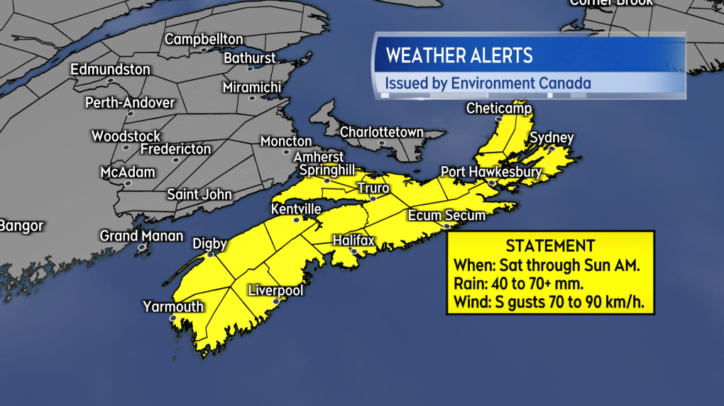
A special weather statement has been issued for the province of Nova Scotia by Environment Canada.
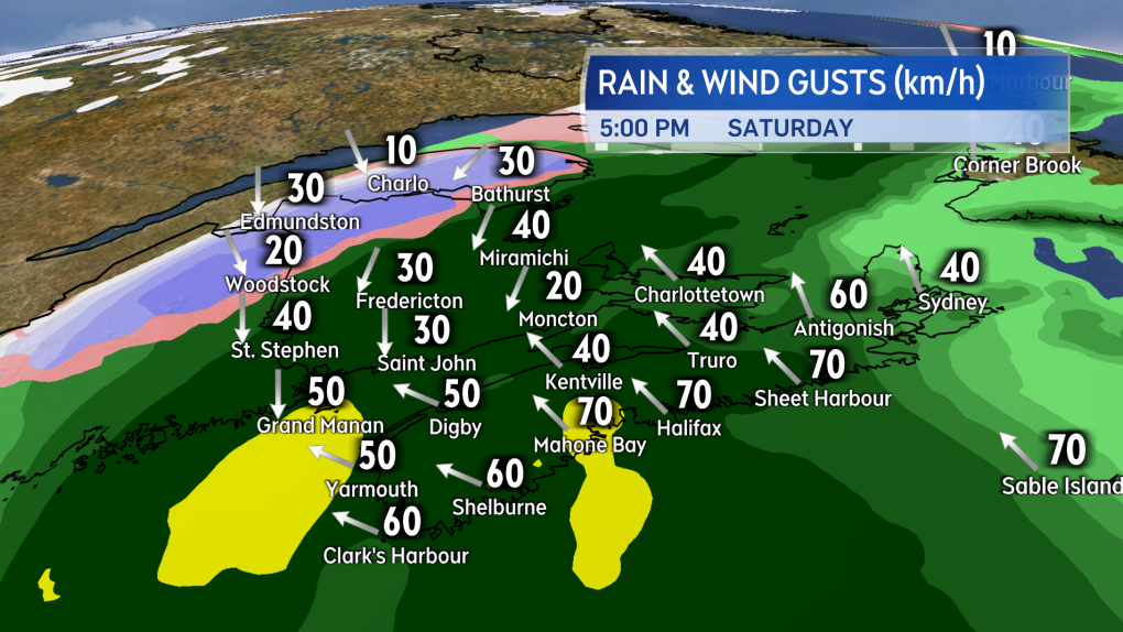
 Weather conditions deteriorate Saturday afternoon and evening. Rain becomes heavier (dark green/yellow) and southerly winds stronger. Wet snow (blue) may be present in northwestern New Brunswick.
The statement is for the heavy rain and high winds that are expected Saturday and ending Sunday morning. The alert cautions rain totals will range from 40 to 70 mm, with a risk of amounts that could exceed 70 mm in some areas. The rain is forecasted to be accompanied by a period of high and gusty southerly winds that could reach peak gusts of 70 to 90 km/h. The agency notes the highest of the wind gusts are most likely on exposed areas of the coast.
 A Special Weather Statement in effect for Nova Scotia.
WET AND WINDY SATURDAY
The inclement weather arrives as a coastal low moving up the eastern U.S. seaboard and combines with a cold front out of the west.
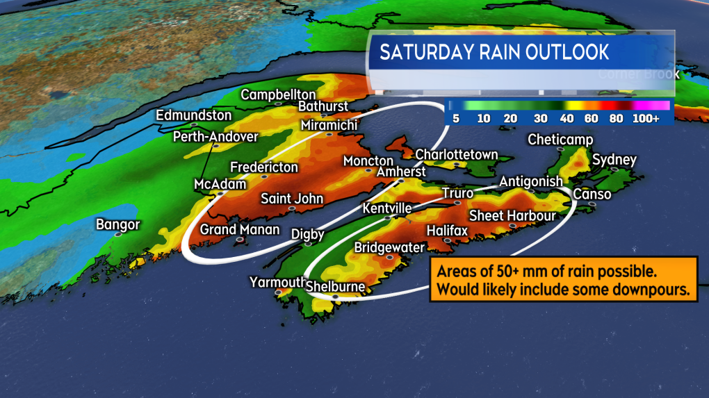
Saturday morning will see a light-to-moderate rain develop in New Brunswick and western Nova Scotia. Saturday afternoon and evening will see the rain increase in intensity and spread across the Maritimes. The greatest risk of downpours and highest rain totals is in southern and eastern areas of New Brunswick, mainland Nova Scotia, and western Prince Edward Island. Pockets of 50 to 100 mm are possible and would increase the risk of localized flooding and flash flooding.
Some snow may mix in with rain for the northwestern corner of New Brunswick. Accumulation of any wet snow would likely be limited to a range of 2 to 10 cm. Higher amounts approaching 15 cm could occur in some of the more mountainous terrain.
The peak of the southerly winds arrives Saturday evening and night. As above, indications are the strongest of the gusts that could approach 90 km/h are most likely up and down the Atlantic coastal side of Nova Scotia. Gusts above 100 km/h are likely Saturday night into early Sunday morning in northern Inverness County, Cape Breton due to the topography of the Highlands.
 Pockets of rain totals exceeding 50 mm are being indicated. Areas in the oranges and reds at most risk of higher rain totals.
HOW TO PREPARE
The weather Thursday and Friday is fair. A good time to check drainage and gutters to ensure they are free of any fall debris. If you sometimes use a sump pump in a heavier rain, you may want to ensure it is in working order.
Give some thought to your Saturday travel and event plans. The rain is expected to become heavy and wind driven for some areas. That could reduce visibility and create hydroplaning conditions on roads.
A number of festive and holiday events are/were scheduled for this weekend. If those events are in an outside venue on Saturday check for delays or cancellations. If the event is rain-or-shine, plan and dress for rain.
Watch CTV News Atlantic programming at 5, 6, and Late, as well as at ctvnewsatlantic.ca, for weather updates.
CTVNews.ca Top Stories

Trump again calls to buy Greenland after eyeing Canada and the Panama Canal
First it was Canada, then the Panama Canal. Now, Donald Trump again wants Greenland. The president-elect is renewing unsuccessful calls he made during his first term for the U.S. to buy Greenland from Denmark, adding to the list of allied countries with which he's picking fights even before taking office.
Quebec fugitive killed in Mexican resort town, RCMP say
RCMP are confirming that a fugitive, Mathieu Belanger, wanted by Quebec provincial police has died in Mexico, in what local media are calling a murder.
Multiple OnlyFans accounts featured suspected child sex abuse, investigator reports
An experienced child exploitation investigator told Reuters he reported 26 accounts on the popular adults-only website OnlyFans to authorities, saying they appeared to contain sexual content featuring underage teen girls.
King Charles ends royal warrants for Ben & Jerry's owner Unilever and Cadbury chocolatiers
King Charles III has ended royal warrants for Cadbury and Unilever, which owns brands including Marmite and Ben & Jerry’s, in a blow to the household names.
DEVELOPING 'Serious safety issues': Evacuation order issued for building where security guard was killed
An apartment building where a security guard was killed earlier this month is being evacuated.
Santa Claus cleared for travel in Canadian airspace
Santa's sleigh has been cleared for travel in Canadian airspace, the federal government announced on Monday just ahead of the busy holiday season.
Ex-OpenAI engineer who raised legal concerns about the technology he helped build has died
Suchir Balaji, a former OpenAI engineer and whistleblower who helped train the artificial intelligence systems behind ChatGPT and later said he believed those practices violated copyright law, has died, according to his parents and San Francisco officials. He was 26.
U.S. House Ethics report finds evidence Matt Gaetz paid thousands for sex and drugs including paying a 17-year-old for sex in 2017
The U.S. House Ethics Committee found evidence that former Rep. Matt Gaetz paid tens of thousands of dollars to women for sex or drugs on at least 20 occasions, including paying a 17-year-old girl for sex in 2017, according to a final draft of the panel's report on the Florida Republican, obtained by CNN.
Young mammoth remains found nearly intact in Siberian permafrost
Researchers in Siberia are conducting tests on a juvenile mammoth whose remarkably well-preserved remains were discovered in thawing permafrost after more than 50,000 years.


