Wednesday storm brings risk of power outages, travel disruptions in the Maritimes
A powerful storm system out of Texas continues to move towards the southern Great Lakes and the northeastern U.S. The storm passes just west of the Maritimes on Wednesday, bringing the region an impactful mix of snow, rain, and high winds.
Here is a breakdown of what each province can expect:
NEW BRUNSWICK
Snow develops quickly across the province Wednesday morning. A turn to rain takes place in the afternoon for southern and central parts of the province. Northern areas of New Brunswick could see a little rain mix in Wednesday evening.
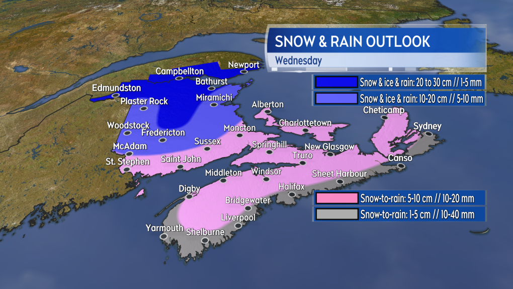
Accumulations in snow and ice pellets will be highest in northern areas of New Brunswick. As much as 20 to 30 cm is expected from Edmundston across to the Acadian Peninsula as well as some of the more mountainous terrain to the north of Fredericton. Much of the rest of New Brunswick can expect 10 to 20 cm of snow though possibly below the 10 cm mark near the Bay of Fundy coastline where the turn to rain may happen quicker. Winter storm and snowfall warnings are in effect.
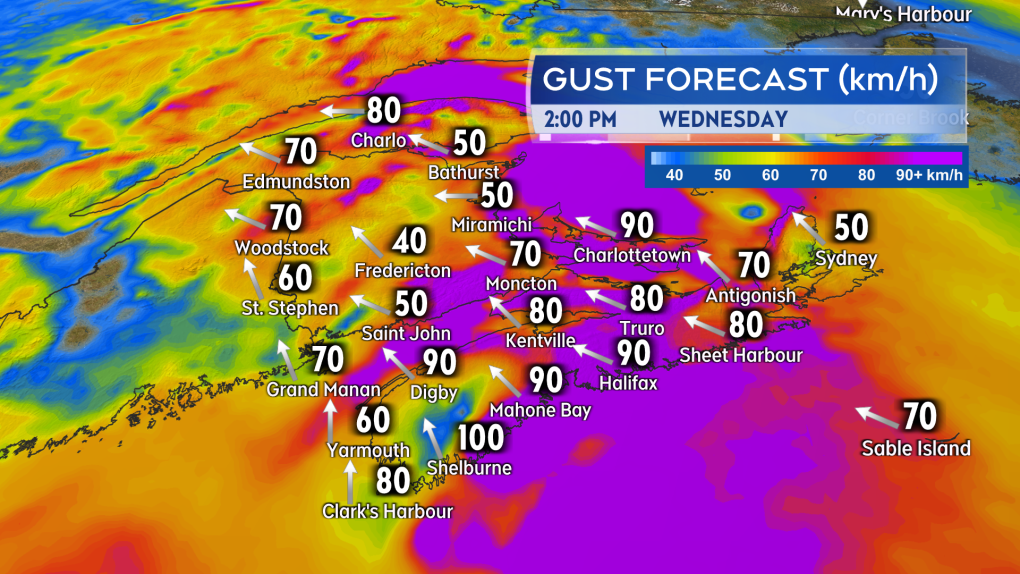
Wind will also be impactful. A southeast wind with widespread gusts of 40 to 70 km/h will accompany the mix of precipitation. Higher wind gusts up to 90 km/h is possible in southern areas of New Brunswick, which are under a wind warning. Gusts on exposed areas of the eastern coastline could also peak near 90 km/h. Wind that strong is often associated with power outages and travel disruptions, such as delays to ferry services. Higher than normal water levels are possible around the Acadian Peninsula and Bay of Chaleur coastlines, especially at high tide.
Weather conditions will improve Wednesday night as the precipitation ends and winds diminish.
 A mix of snow and rain is expected for much of the Maritimes on Wednesday. The most snow is expected in central and northern areas of New Brunswick.
NOVA SCOTIA
Snow will be falling across much of western Nova Scotia by 8 a.m. Wednesday. The snow will be filling in across eastern Nova Scotia, including into Cape Breton, by near noon. A turn to rain is expected in Halifax and western areas by near noon. Eastern areas of Nova Scotia will turn to rain by early evening.
Initial snow amounts of 5 to 10 cm are possible for much of Nova Scotia before the turn to rain. Snow amounts may total less than 5 cm for Atlantic coastal areas. Higher snow totals of 10 to 20 cm are possible in the highest terrain of the Cape Breton Highlands.
The rain will total 10 to 40 mm, and keep in mind that snow and ice melt will add to the runoff. More runoff is also possible due to the frozen ground and possible drainage blocked by snow and ice. Rainfall warnings are in effect for much of mainland Nova Scotia.
A strong southeast wind will accompany the snow turning to rain. Peak gusts of 70 to 110 km/h are possible for the province. Gusts will be reaching or exceeding 130 km/h Wednesday evening in northern Inverness County, Cape Breton, due to the topography of the Highlands. Scattered power outages are likely, as well as disruption to travel services. A wind warning is in effect for the province. Higher than normal water levels are possible on parts of the coast as a result of large waves and the strong wind.
Weather conditions will improve Wednesday evening and night as the precipitation ends and winds begin to diminish. Western areas will see improvement first, followed by eastern locations, such as Cape Breton.
 By near noon, snow is expected to have turned to rain for western Nova Scotia and parts of southwestern New Brunswick.
PRINCE EDWARD ISLAND & MAGDALEN ISLANDS
Snow will be falling in Prince Edward Island by noon on Wednesday. A turn through ice pellets to rain is expected by late afternoon. Five to 10 cm of snow could accumulate before the turn to rain, which is expected to total 5 to 15 mm. No warnings are currently in effect for the snow or rain expected in P.E.I., but the slushy mix of weather will create slippery roads.
The province will also be impacted by the strong southeast wind. Wind is expected to pick up for the afternoon and early evening with peaks gusts near 90 km/h. There will be risk of power outages and travel disruptions. A wind warning is in effect for P.E.I.
A wind warning is also in effect for the Magdalen Islands. Southeast gusts up to 100 km/h is expected Wednesday afternoon and evening.
Weather conditions will improve Wednesday night as the precipitation ends and the winds diminish.
 Winds strong enough to create scattered power outages and travel disruptions are expected with the storm.
SUMMARY
This is a large storm system with widespread inclement weather for the region. Due to the mix of precipitation, conditions will be highly varied across the Maritimes. The strong wind associated with the passing storm will be felt across much of the Maritimes.
I’ll have updates, timelines, and regional weather conditions on CTV News Atlantic programming and at ctvnewsatlantic.ca.
CTVNews.ca Top Stories

Fall sitting bookended by Liberal byelection losses ends with Trudeau government in tumult
The House of Commons adjourned on Tuesday, bringing an end to an unstable fall sitting that has been bookended by Liberal byelection losses. The conclusion of the fall sitting comes as Prime Minister Justin Trudeau's minority government is in turmoil.
2 B.C. police officers charged with sexual assault
Two officers with a Vancouver Island police department have been charged with the sexual assault of a "vulnerable" woman, authorities announced Tuesday.
Canadian government announces new border security plan amid Donald Trump tariff threats
The federal government has laid out a five-pillared approach to boosting border security, though it doesn't include specifics about where and how the $1.3-billion funding package earmarked in the fall economic statement will be allocated.
B.C. teacher disciplined for refusing to let student use bathroom
A teacher who refused to let a student use the bathroom in a B.C. school has been disciplined by the province's professional regulator.
Most Canadians have heard about Freeland's resignation from Trudeau cabinet, new poll finds
The majority of Canadians heard about Chrystia Freeland's surprise resignation from Prime Minister Justin Trudeau's cabinet, according to a new poll from Abacus Data released Tuesday.
Police chief says motive for Wisconsin school shooting was a 'combination of factors'
Investigators on Tuesday are focused on trying to determine a motive in a Wisconsin school shooting that left a teacher and a student dead and two other children in critical condition.
After investigating Jan. 6, House GOP sides with Trump and goes after Liz Cheney
Wrapping up their own investigation on the Jan. 6 2021 Capitol attack, House Republicans have concluded it's former GOP Rep. Liz Cheney who should be prosecuted for probing what happened when then-President Donald Trump sent his mob of supporters as Congress was certifying the 2020 election.
Wine may be good for the heart, new study says, but experts aren’t convinced
Drinking a small amount of wine each day may protect the heart, according to a new study of Spanish people following the plant-based Mediterranean diet, which typically includes drinking a small glass of wine with dinner.
The Canada Post strike is over, but it will take time to get back to normal, says spokesperson
Canada Post workers are back on the job after a gruelling four-week strike that halted deliveries across the country, but it could take time before operations are back to normal.


