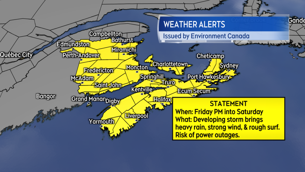
Alerts issued for Maritimes ahead of Friday storm that risks power outages
Environment Canada has issued special weather statements for all three Maritime provinces for Friday afternoon into Saturday.
During that time, Environment Canada cautions that “the potential exists for strong winds accompanied by significant amounts of rain which may also impact travel,” and that, “utility outages are possible with this system.”
 Environment Canada issued a special weather statement for the Maritimes on Tuesday. (Kalin Mitchell/CTV)
There are indications that widespread peak gusts from the southeast could exceed 80, 90, and even 100 km/h in the Maritimes Friday night into early Saturday morning.
Comparable weather scenarios that have happened in the past have been associated with power outages in the region.
Along with being prepared for a possible outage, I would also recommend that holiday decorations be secured or brought inside to prevent damage or loss.
The strong wind will diminish and turn southwesterly through the day Saturday.
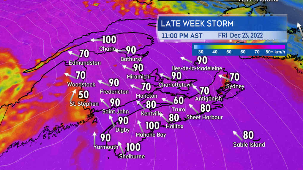 Wind strength increases Friday afternoon into Friday night. The strong wind poses a risk of power outages. (Kalin Mitchell/CTV)
Primarily a rain event for a large portion of the region, rain totals could range from 20 to 60 mm. Downpours within the rain could lead to a risk of hydroplaning conditions on roads and localized flooding.
A turn from rain to some accumulating snow Saturday morning can’t be ruled out yet. That would be most likely in New Brunswick and western Prince Edward Island.
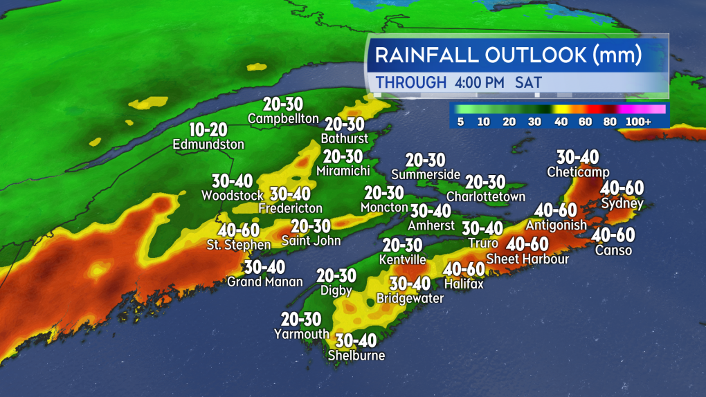 The storm is expected to bring some heavy rain into the region Friday night and early Saturday morning. A turn to some accumulating snow before the rain clears can’t be ruled out. (Kalin Mitchell/CTV)
The stormy weather also poses some hazards to coastal areas. South-facing shorelines of the Atlantic coast of Nova Scotia are advised that a run of spring tides and large waves could pose a storm surge risk Friday night into Saturday.
Prince Edward Island is advised to expect higher-than-normal water levels near the high tide on Saturday. Coastal erosion and damage are listed as a risk for the bay of Chaleur and the Acadian Peninsula in New Brunswick late Friday into Saturday with the highest risk Saturday afternoon.
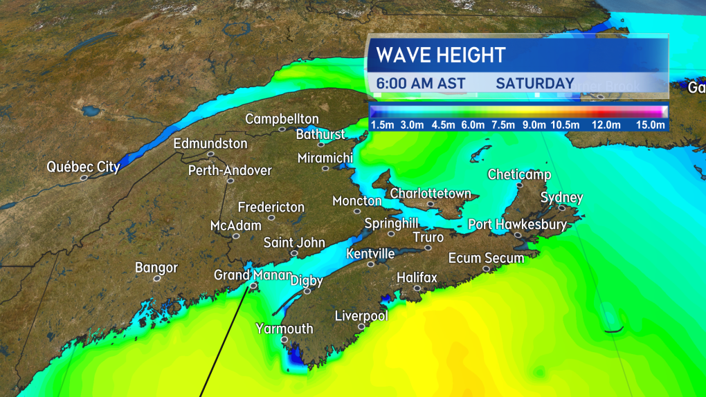 Large waves, onshore winds, and high tides may contribute to storm surge conditions along parts of the coast Friday night into Saturday. (Kalin Mitchell/CTV)
This is a large and sprawling storm system. Severe weather impacts are expected from Atlantic Canada west into Quebec and Ontario. If travelling that area Friday through Saturday, be aware that roads, ferry services and airports could all be impacted for periods of time.
Updates to come through the week.


CTVNews.ca Top Stories

Board orders deportation for trucker in horrific Humboldt Broncos crash
The truck driver who caused the horrific bus crash involving the Humboldt Broncos junior hockey team has been ordered to be deported.
Community mourns victims of fatal boat crash near Kingston, Ont.
The three people killed in last weekend's tragic collision between a speedboat and a fishing boat north of Kingston are being remembered Friday.
A woman took her dog to a shelter to be euthanized. A year later, the dog is up for adoption again
Exhausted and short on options after consulting two veterinary clinics, Kristie Pereira made the gut-wrenching decision last year to take her desperately ill puppy to a Maryland shelter to be euthanized.
Group tied to Islamic State plotted fatal Ontario restaurant shooting: Crown
A gunman who is accused of killing a young Ontario man and shooting four of his family members at their small Mississauga restaurant in 2021 was allegedly part of a trio who had pledged allegiance to the listed terrorist group Islamic State, a Crown attorney said in an opening statement in the Brampton murder trial this week.
'A really bad car crash': Why health experts are raising concerns over surging syphilis cases
A sexually transmitted infection (STI) that was once thought to be a thing of the past is now a public health priority for North American doctors.
Purolator truck drivers from Guelph, Ont. save man walking in Hwy. 407 lanes
A pair of Purolator transport truck drivers from Guelph, Ont. are being hailed as heroes for their efforts in helping a person in crisis.
Trudeau responds to American senators calling on Canada to increase defence spending
Stopping short of offering the assurance U.S. senators are seeking, Prime Minister Justin Trudeau said his government is aware there's more work to do in order to see Canada meet NATO's defence spending target.
Toddler dies after being struck by recycling truck in Barrie, Ont. neighbourhood
A toddler has died after being struck by a recycling truck in a Barrie, Ont. neighbourhood on Thursday afternoon.
Milk sold in Canadian grocery stores tested for avian influenza; results released
As avian flu spreads south of the border, Canadian officials are now testing samples of milk sold in grocery stores across the country.
Shopping Trends
The Shopping Trends team is independent of the journalists at CTV News. We may earn a commission when you use our links to shop. Read about us.


Toronto
-

1 dead, 3 in hospital after flying wheel crashes into bus windshield on QEW
A man is dead, and three others are in hospital after a flying wheel crashed into a coach bus on the QEW in St. Catharines.
-
Colt Keith hits first MLB HR, Maeda throws 5 scoreless innings and Tigers beat Blue Jays 6-2
Colt Keith hit his first major league home run and Kenta Maeda threw five scoreless innings in his return to help the Detroit Tigers beat the Toronto Blue Jays 6-2 on Friday night and snap a season-high, five-game losing streak.
-
Police release photos of suspects accused of assaulting, robbing good Samaritan at TTC station
A good Samaritan who stepped in to help another person was assaulted by two suspects at a TTC station in Scarborough earlier this week, Toronto police say.
Calgary
-

MRU prof calls out institution for lack of action against anti-Semitism on campus
Months after a troubling encounter on the Mount Royal University campus, which ended in a criminal charge against a protester, a professor is calling out the institution for not doing more to provide a safe environment for Jewish faculty and students.
-
'Poor communication': Calgary ticketholders uncertain about rescheduled 'Banksy' event
Uncertainty is growing among customers who bought tickets for an upcoming show in Calgary featuring the works of renowned street artist Banksy.
-
Humboldt Broncos crash victims and families react to decision to deport truck driver
The family of one of the victims of the Humboldt Broncos bus crash in 2018 says they are 'thankful' for a decision by a Calgary immigration board to deport the driver of the truck involved.
Edmonton
-

Edmonton teen murder victim was fatally stabbed, autopsy shows
A 15-year-old boy who was killed in Edmonton earlier this week was fatally stabbed, an autopsy has confirmed, and his death has been deemed a homicide.
-
Killing penalties an Oilers 'X' factor this post-season
The Oilers' penalty-killers stuck to the script they've been performing to near-perfection in this year's NHL post-season by holding the Stars' power-play attack along the perimeter and not allowing it many good chances to take the first game of the Western Conference Final.
-
Alberta municipal leaders criticize vagueness of Bill 20 amendments
Alberta's premier says changes to a controversial bill are expected to be widely accepted by the province's municipalities. Leaders of them, however, are saying the opposite of Bill 20, arguing the legislation introduced a month ago in the legislature continues to threaten democracy.
Montreal
-

Man, 32, serving life sentence for killing victim with sword escapes from Quebec prison
A warrant has been issued for 32-year-old Yacine Zouaoui, who went unaccounted for at the minimum security Federal Training Centre.
-
Montreal cyclists continue to skirt rules despite 4-year-old getting hit
Ten days after a four-year-old girl was struck by a cyclist while crossing Jeanne Mance Street in Montreal's Plateau borough, another video was posted showing multiple cycling infractions on the same stretch of road.
-
Driver in life-threatening condition after crashing into tree in the Laurentians
A driver was seriously injured after colliding with a tree Friday afternoon in the Laurentians, Quebec provincial police say.
Ottawa
-

Community mourns victims of fatal boat crash near Kingston, Ont.
The three people killed in last weekend's tragic collision between a speedboat and a fishing boat north of Kingston are being remembered Friday.
-
Childhood cancer treatment inspires Ottawa woman's half-marathon fundraiser
Six months of hard work is about to pay off for Jill Barr as she gets ready to run her first half-marathon. She's one of thousands training for Tamarack Ottawa Race Weekend. For her, it's personal.
-
Here's what you need to know about Ottawa Race Weekend this weekend
Thousands of runners will lace up their sneakers this weekend for the Tamarack Ottawa Race Weekend. Here is everything you need to know about Tamarack Ottawa Race Weekend, including road closures.
London
-

'God forgives but we don’t': Loud outburst from stabbing victim’s family during sentencing hearing
An emotional outburst in a London, Ont. courtroom Friday disrupted the sentencing hearing of a woman who pleaded guilty for her part in the death of a 29-year-old Mohammed Abdallah.
-
'Their life still needs to be celebrated': Photographers sought to capture dying newborns with their families
Volunteers are needed for a London, Ont. group with a heartfelt mission. It consists of photographers who tastefully capture the final moments of dying newborn infants with their families.
-
'Fired up' London Knights ready to open Memorial Cup tournament Saturday
The London Knights enjoyed an off day Friday in Saginaw, Mich. with a light skate and some media duties. They will start the Memorial Cup tournament Saturday afternoon against Drummondville, the champions of the Quebec Major Junior Hockey League.
Barrie
-
Toddler dies after being struck by recycling truck in Barrie, Ont. neighbourhood
A toddler has died after being struck by a recycling truck in a Barrie, Ont. neighbourhood on Thursday afternoon.
-
Arrest made in 2022 fatal shooting of woman in Alliston, Ont.
Police have made an arrest nearly two years after a woman was gunned down in front of her Alliston, Ont. home.
-
Barrie man convicted of sex crimes arrested after failing to show for sentencing hearing
Police confirm the 50-year-old Barrie man convicted of sex crimes involving a child, who failed to show up for his sentencing hearing on Thursday, has been arrested.
Northern Ontario
-

Suspect sought in suspicious death in northern Ont.
Ontario Provincial Police in Cochrane are asking for the public’s help in locating a man they want to speak with in connection with a suspicious death.
-
Lack of services means at-risk youth in the north sleeping in hotels, Airbnbs
Dozens of young people in the care of the Children’s Aid Society will be going to sleep tonight in motels, hotels, and short-term rentals because there aren’t enough foster beds or treatment facilities.
-
Out-of-control fire rages southeast of Cobalt, Ont.
A now 134-hectare fire is burning three kilometres southeast of Cobalt near the east shore of Kerr Lake, the province’s Aviation, Forest Fire and Emergency Services says.
Kitchener
-

Purolator truck drivers from Guelph, Ont. save man walking in Hwy. 407 lanes
A pair of Purolator transport truck drivers from Guelph, Ont. are being hailed as heroes for their efforts in helping a person in crisis.
-
Missing 12-year-old boy last seen in Kitchener
Police are searching for a missing 12-year-old boy named Reuben.
-
Waterloo unveils fully accessible, self-cleaning washroom
A new public washroom has opened in Uptown Waterloo and not only can it self-clean, but it's all fully accessible.
Windsor
-

Bodies recovered in search off Sandpoint Beach
Windsor police report the bodies of two young men swept underwater by the current near Sandpoint Beach on Thursday have been recovered.
-
Erie Street shooting suspect arrested while attempting to board plane: Windsor police
A 23-year-old man who allegedly shot at a vehicle during a dispute on Erie Street East earlier this week was arrested Friday while attempting to board a flight out of the country, according to Windsor police.
-
Plans for boutique hotel go up in smoke — for now
Fire crews in Windsor are working to put out a blaze at a former city bar. Crews were called to the scene of the former Champs bar in the area of Wyandotte Street and Parent Avenue on Friday morning.
Winnipeg
-

School division says Grade 12 exam suspended
Some Grade 12 students will not be writing their ELA exams Monday.
-
Rain, snow hit parts of southern Manitoba as system moves north from the U.S.
Parts of southern Manitoba have been hit by a lot of rain, and even snow, as a low-pressure system moves in from the United States.
-
Late-night intruder steals ice-cream sandwiches from Elmwood shop
There was nothing sweet about the unwelcome intruder at Sub Zero Ice Cream in Elmwood – the latest in what residents and businesses say is a growing number of break-ins in the area.
Regina
-

Sask. first responders speak out following social media posts of accident scene
Yorkton Protective Fire Services is asking the public to have some compassion when taking photos and videos during the aftermath of accidents.
-
Regina Thunder loans jerseys to Regina Riot in time of need
The Regina Riot football team will be donning another local football team’s colours this Sunday at Leibel Field.
-
Human remains found in Canora, Sask.
An investigation us underway after RCMP say human remains were found in the town of Canora about 50 kilometres north of Yorkton.
Saskatoon
-
Board orders deportation for trucker in horrific Humboldt Broncos crash
The truck driver who caused the horrific bus crash involving the Humboldt Broncos junior hockey team has been ordered to be deported.
-
Saskatoon police investigating after two people stabbed on city bus
Saskatoon police are investigating after a 20-year-old man and a 15-year-old girl were stabbed on a city bus Thursday night.
-
Sask. swimmer qualifies for 2024 Olympic Games, sets Canadian record
A swimmer from Saskatoon has qualified for the 2024 Olympic Summer Games in Paris.
Vancouver
-

Whitecaps fans frustrated superstar Messi will miss Vancouver vs. Miami game
Marc DeLuca and his wife had the perfect sixth birthday gift for their son, Jack — tickets to see Lionel Messi and Inter Miami CF play the Whitecaps in Vancouver.
-
BC SPCA appeals for donations with high demand for pet food banks
The sustained period of above-target inflation has put major pressure on all of us – so it's no wonder pet food donations are down at the BC SPCA.
-
PNE announces sponsor for new amphitheatre, asks public to vote on name
Freedom Mobile's name will be on the new, $103-million PNE amphitheatre when it opens in 2026, but what exactly comes after the company's name remains to be decided.
Vancouver Island
-

RCMP officer's social media posts prompt calls for suspension from First Nation chief
A British Columbia First Nation is calling for the suspension and removal of an RCMP officer from Bella Bella over social media posts he made before joining the Mounties.
-
IIO investigating after police vehicle hits cyclist on Vancouver Island
British Columbia's police oversight agency is investigating after a police vehicle struck a cyclist on Vancouver Island earlier this week.
-
Whitecaps fans frustrated superstar Messi will miss Vancouver vs. Miami game
Marc DeLuca and his wife had the perfect sixth birthday gift for their son, Jack — tickets to see Lionel Messi and Inter Miami CF play the Whitecaps in Vancouver.
Kelowna
-
'Altercation' in Penticton leaves 1 dead: RCMP
One person is dead after a fight in Penticton early Sunday morning, according to authorities.
-
Suspect fled in 2-door Fiat after convenience store robbery, Merritt RCMP say
A suspect is at large after robbing a convenience store at gunpoint in Merritt, B.C., Friday, according to local police.
-
Kamloops RCMP issue public warning about 2 men allegedly at centre of 'organized crime conflict'
After four targeted shootings in four days, Mounties in Kamloops are taking the unusual step of warning the public about two men they believe are likely to be targeted in future violent incidents.


