Cold lingers into the weekend; snowy Sunday possible for parts of the Maritimes
A snap of colder January air will linger in the Maritimes into this weekend.
Combined with a gusty northwest wind, it is putting a bit of bite into the air. Wind chill values on Friday made it feel as cold as well down into the minus teens and some near -20. A similar wind chill is expected Saturday night and Saturday.
The cold northwest wind blowing over open ocean waters will bring flurries onshore for some areas. That type of snow is likely to be most persistent around eastern P.E.I., the North Shore of mainland Nova Scotia, and Inverness County in Cape Breton Friday night and Saturday. Most snow accumulation should be held in the range of a few to several centimetres, but could total 10 to 20 cm in the higher elevations of the Cape Breton Highlands.
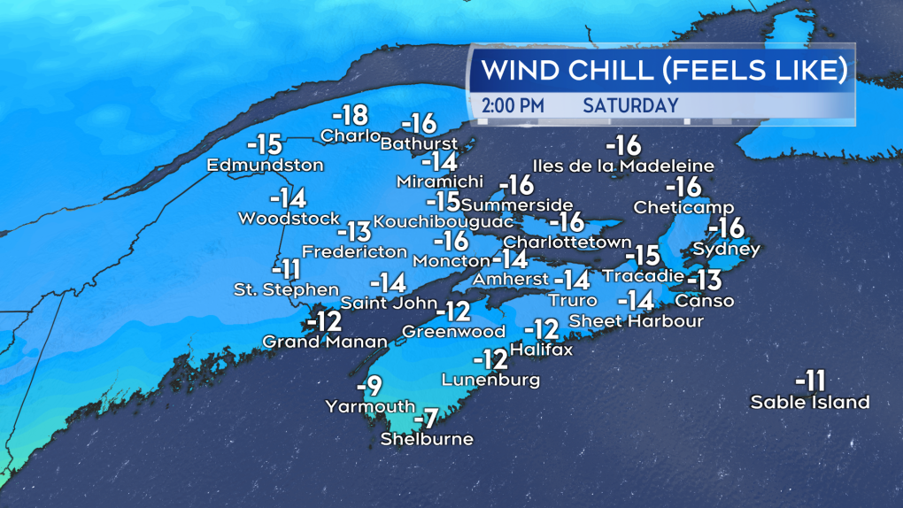 Cold air and a blustery northwest wind will make wind chill a factor on Saturday.
A coastal storm is still forecast to move up the eastern seaboard of the United States to a position near Cape Cod. From there, it is expected to pass just to the south and east of Nova Scotia. How much snow and where will depend on how close the system gets to the southwest corner of the province. The closer it gets, the more snow is possible in western Nova Scotia. The further out it stays, the lighter the snow will be.
As it stands, I prefer an outlook that has 5 to 10 cm of snow possible from Halifax back through the Annapolis Valley. Ten to 20 cm of snow is then possible down the South Shore. There is a risk of a bullseye of 20 to 30 cm of snow for Yarmouth and Shelburne Counties. Even if there is some change over the weekend, at the very least that gives a good idea of what part of the Maritimes should be monitoring the Sunday forecast more carefully.
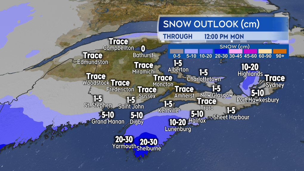 The potential for snow on Sunday reaching or exceeding 10 cm is highest in the southwest of Nova Scotia.
Environment Canada has a special weather statement in effect for western Halifax County, the South Shore, along with Digby and Annapolis Counties. It calls for a potential 5 to 20 cm snowfall, with the higher amounts most likely in Yarmouth and Shelburne Counties. The statement also cautions of easterly gusts up to 60 km/h that could blow the snow around, reducing visibility.
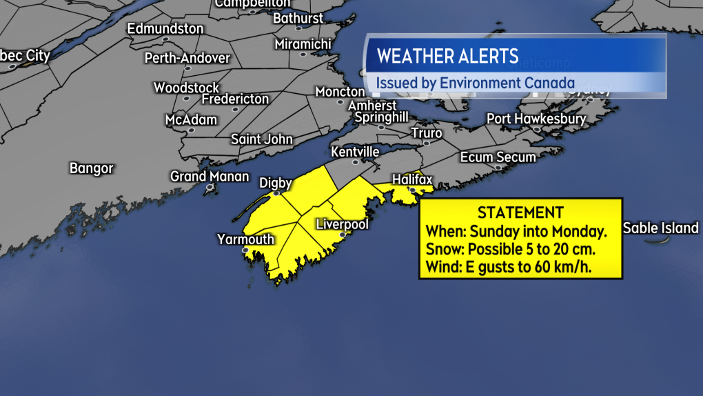 A special weather statement is in effect ahead of the possible Sunday snowfall.
The snow could begin as early as Sunday morning in the southwest of Nova Scotia. It would then spread up to Halifax County by Sunday evening. The snow would then ease to flurries through Sunday night, with remaining flurries ending Monday morning.
I’ll have updates on CTV News Atlantic programming and at ctvnewsatlantic.ca.
Shopping Trends
The Shopping Trends team is independent of the journalists at CTV News. We may earn a commission when you use our links to shop. Read about us.


CTVNews.ca Top Stories

DEVELOPING
DEVELOPING Trump calls Canada-U.S. border 'artificially drawn line'
U.S. president-elect Donald Trump says he's open to using 'economic force' to acquire Canada as a state.
BREAKING
BREAKING Trump refuses to rule out use of military force to take control of Greenland and the Panama Canal
U.S. president-elect Donald Trump on Tuesday said he would not rule out the use of military force to seize control of the Panama Canal and Greenland, as he declared U.S. control of both to be vital to American national security.
As walking pneumonia rates drop among Canadian children, flu and RSV are back
Following a sharp rise, cases of walking pneumonia across Canada, particularly among children, seem to be dropping.
CRA to continue with capital tax changes despite prorogation: finance department
The federal government says the Canada Revenue Agency will continue to administer the capital gains tax, even though it hasn't passed in Parliament, which is prorogued until March 24.
Justin Trudeau's set to go after the Liberals pick his replacement, what now?
Prime Minister Justin Trudeau, announcing Monday that he intends to resign as Liberal leader and prime minister as soon as his party names his replacement, has set a series of political machinations in motion.
Bank CEOs see mortgage risk easing as attention turns to political uncertainty
Canadian bank CEOs say they see the risks around mortgage renewals easing, while they prepare for rising risks around tariffs and political uncertainty.
Walmart's version of the Hermes Birkin has taken over the internet
Budget-conscious buyers looking for luxury alternatives have flocked to Walmart's Birkin bag look-alike, nicknamed the 'Wirkin.'
Canada Post says most operations are back to normal, but some mail continues to be delayed
Canadians can expect full service for domestic parcels and on-time service guarantees, though Canada Post said some mail will continue to be delayed as it deals with a large amount of items.
Justin Trudeau steps down as Liberal leader. Who are the top contenders to replace him?
With Prime Minister Justin Trudeau's resignation as Liberal party leader, several well-known political faces may be waiting in the wings for their opportunity to take his place.
Toronto
-

'Money we don't have to spare': Spoofed website causes Toronto man to lose $100K
A Toronto man says he lost $100,000 in a matter of minutes after falling victim to a website spoof scam.
-
DEVELOPING
DEVELOPING Trump calls Canada-U.S. border 'artificially drawn line'
U.S. president-elect Donald Trump says he's open to using 'economic force' to acquire Canada as a state.
-
Ontario launches border-strengthening operation as Trump tariff threat looms
The Ontario government says it has launched an operation intended to beef up security along the border with the United States.
Calgary
-

Calgary's lone Liberal MP thanks Trudeau, but says it was time for him to go
Justin Trudeau's announcement on Monday that he intends to resign as prime minister and Liberal leader was needed 'to move our country forward,' says Calgary's only Liberal MP.
-
WEATHER
WEATHER Daytime highs hover around 5 C under chinook conditions this week
Westerly winds will continue to flow across the southern Rockies elevating temperatures east of the range.
-
Gaudreau suspect pleads not guilty to homicide charges after turning down 35-year prison sentence
The driver charged with killing NHL hockey player Johnny Gaudreau and his brother, Matthew, as they cycled on a rural New Jersey road pleaded not guilty to the indictment Tuesday after turning down a prosecution offer of 35 years in prison.
Edmonton
-

Justin Trudeau steps down as Liberal leader. Who are the top contenders to replace him?
With Prime Minister Justin Trudeau's resignation as Liberal party leader, several well-known political faces may be waiting in the wings for their opportunity to take his place.
-
Oilers on torrid pace as Bruins search for winning edge
Edmonton makes the cross-country trek to continue a four-game road trip following a 4-2 win Sunday at the Seattle Kraken, its third straight victory and 14th in the last 18 games (14-3-1).
-
'We're in an epidemic': Deaths of two women in alleged domestic abuse cases raising red flags
Advocates for domestic abuse survivors say the deaths of an Edmonton woman and a Calgary mother and her father over the holidays shows domestic abuse is an “epidemic.”
Montreal
-

Ship stuck in St. Lawrence River for two weeks could be freed today
A ship that has been stuck in the St. Lawrence River northeast of Montreal since Christmas Eve could be freed today.
-
CSN wants transparency after layoffs at Amazon's Laval warehouse
The union representing workers at Amazon's Laval, Que. warehouse is claiming that at least 30 people have just learned that they will be losing their jobs.
-
Health authorities advise caution as flu season intensifies
Quebec's Health and Social Service Ministry says the influenza season is intensifying while cases of the common cold are stabilizing. However, the situation could change rapidly as students gradually return to school this week.
Ottawa
-

Homeless man found 'frozen to death' in downtown Ottawa, councillor says
Somerset ward councillor Ariel Troster says she's "devastated" after a man sleeping in the streets of downtown Ottawa was found "frozen to death" on Monday.
-
Ford not focused on Ontario snap election amid U.S. tariff threat, federal turmoil
Ontario Premier Doug Ford said he's focused on fighting a proposed tariff threat from incoming U.S. president Donald Trump, not an early snap election, amid ongoing turmoil political on Parliament Hill.
-
Ottawa mayor says prorogation of parliament gives city time to work with MPs on transit funding request
Ottawa Mayor Mark Sutcliffe says he remains optimistic that the City of Ottawa will eventually get the transit funding it has requested from the federal government, despite Monday's announcement by Prime Minister Justin Trudeau that Parliament has been prorogued and that he intends to step aside as Liberal leader and prime minister.
London
-

One person arrested in connection to suspicious death in north London
Police have arrested a man in connection to a suspicious death investigation that took place in the north end of the city.
-
Snow squall watch in effect for London area
We’re in for a brisk start to the week, set to continue for the foreseeable future.
-
New lawn signs to educate and reduce conflict over naturalized front yards in London
An advisory committee at city hall is offering new signs meant to end turf wars between London homeowners with naturalized yards and those with manicured lawns.
Barrie
-

Police warn about ‘aggressive text scam’ circulating locally
The Barrie police fraud unit is warning residents about an “aggressive text messaging scam” it says is circulating locally.
-
Yellow alert by Canada Post in effect in Simcoe County
Canada Post has issued a statement indicating yellow alerts for delivery are still in effect in some areas.
-
Man accused of attempted murder in alleged hit-and-run granted bail
A man accused of attempted murder in connection to an alleged hit-and-run has been granted bail.
Northern Ontario
-

Fatal crash between pickup, train in northern Ontario
The driver of a pickup truck has died following a collision with a train in northern Ontario on Tuesday morning.
-
Snowmobile driver suffers life-altering injuries in New Year's Eve crash
Ontario Provincial Police are investigating a northern snowmobile crash that sent a man to hospital with life-altering injuries on New Year's Eve.
-
Hwy. 17 traffic complaint leads to impaired, other charges
Provincial police have charged a 33-year-old man from Gravenhurst after another motorist reported a possible impaired driver.
Kitchener
-

Waterloo Regional Police Service helps recover 20 stolen vehicles in Hamilton, Ont.
Waterloo Regional Police Services helped recover 20 stolen vehicles in Hamilton, Ont.
-
Uncertainty surrounds college semester in Ontario as strike deadline looms
Students at Ontario’s 24 public colleges are beginning their winter semester under the cloud of a potential strike.
-
Brantford General Hospital experiencing 'significantly higher patient volumes'
Anyone headed to the Brantford General Hospital emergency department may have a long wait ahead of them.
Windsor
-

$400,000 in drugs seized after police uncover drug trafficking operation
Two suspects have been arrested and over $400,000 in illicit drugs seized after a months-long investigation.
-
Ontario targets cross-border crime with 'Operation Deterrence': What it means for Windsor-Detroit crossings
The Windsor-Detroit corridor, a critical hub for trade and travel between Canada and the United States, stands to be impacted by Ontario’s newly announced “Operation Deterrence.”
-
DEVELOPING
DEVELOPING Trump calls Canada-U.S. border 'artificially drawn line'
U.S. president-elect Donald Trump says he's open to using 'economic force' to acquire Canada as a state.
Winnipeg
-

Winnipeg police holiday checkstop program ends with nearly 4,000 vehicles stopped
Nearly 4,000 vehicles were stopped by Winnipeg police over the last four weeks as part of its holiday checkstop program.
-
High-risk offender released, expected to live in Winnipeg
Winnipeg police are warning the public that a high-risk offender has been released from jail and is expected to live in Winnipeg.
-
Vacant Winnipeg church goes up in flames
Freezing temperatures created challenging conditions as crews battled a blaze at a vacant church on Monday.
Regina
-

Regina police lay murder charge in connection with December homicide
Regina police say a 21-year-old man has been charged with second degree murder in connection to a homicide that took place on Dec.3.
-
Regina saw a record number home sales in 2024, report says
Above average home sales throughout 2024 translated into a record year for Regina that saw nearly 4,000 sales made.
-
'We welcome you': Regina's Carmichael Outreach hoping to help neighbouring homeless encampment
Carmichael Outreach has seen a busy start to the new year due to cold weather hitting Regina. On a regular day, the charity organization sees around 50 people come through their doors.
Saskatoon
-

These 90-year-old identical twins were born on a Saskatchewan farm, but grew to love the city
Rose Worona and Anne Skwarchuk were born in 1935 on a farm near Hafford. Now, they’re celebrating their 90th birthday together.
-
Crews battle garage fire in Saskatoon's Sutherland neighbourhood
Saskatoon firefighters battled a garage fire in Sutherland on Monday.
-
Judge condemns murder trial delay, asks lawyers to 'turn around' and look at the public 'we serve'
A Saskatoon murder trial opened on Monday with the judge sharply criticizing the time it’s taken to get to trial.
Vancouver
-

Support for federal Conservatives on the rise in B.C.: new poll
We’re learning more about how British Columbians plan to vote in the next federal election following Prime Minister Justin Trudeau’s bombshell resignation.
-
'Aggressive cougar' closes popular Vancouver Island hiking trail
Authorities have ordered the closure of a popular hiking trail on Vancouver Island due to the presence of an 'aggressive cougar.'
-
Study reveals annual activity of sneezing sea sponge off B.C. coast
A study into the behaviour of a sea sponge off the coast of British Columbia has revealed the animals have the humanlike ability to sneeze.
Vancouver Island
-

'Aggressive cougar' closes popular Vancouver Island hiking trail
Authorities have ordered the closure of a popular hiking trail on Vancouver Island due to the presence of an 'aggressive cougar.'
-
Support for federal Conservatives on the rise in B.C.: new poll
We’re learning more about how British Columbians plan to vote in the next federal election following Prime Minister Justin Trudeau’s bombshell resignation.
-
Study reveals annual activity of sneezing sea sponge off B.C. coast
A study into the behaviour of a sea sponge off the coast of British Columbia has revealed the animals have the humanlike ability to sneeze.
Kelowna
-

1 hospitalized, residents displaced after Kelowna apartment fire
Firefighters knocked down a blaze on the third floor of a low-rise apartment building near downtown Kelowna Monday afternoon.
-
Lost skiers rescued off B.C. mountain
Search and rescue volunteers in B.C.’s Okanagan successfully reunited two skiers with their family Friday evening.
-
Charges laid after child porn investigation that 'spanned several different countries,' Kelowna RCMP say
Police in Kelowna say an international investigation has led to child pornography charges against a 46-year-old man.


