Eastern Nova Scotia brushed by snow Thursday; snow and rain more widespread Friday into Saturday
 A pedestrian makes their way through a snowstorm in Halifax on Tuesday, January 31, 2023. (THE CANADIAN PRESS/Darren Calabrese)
Thursday outlook
A low pressure system over the Atlantic Ocean will brush eastern areas of Nova Scotia with a mix of snow and ice pellets Thursday afternoon through the evening.
Eastern Halifax County, Guysborough County, Antigonish County, Richmond County, and Cape Breton County could pick up some accumulation of 2 to 8 cm. A chance of flurries for the South Shore of Nova Scotia through western Halifax County, with not much more than some increased cloudiness for the remainder of the Maritimes on Thursday. There is a chance of some light, patch freezing drizzle in western New Brunswick Thursday night.
That same system will go on to bring a more significant mix of snow, ice pellets, and freezing rain to central and eastern Newfoundland Thursday night through Friday morning.
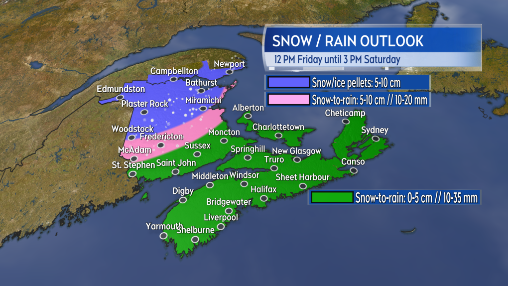 Mostly rain for a large portion of the Maritimes Friday evening through Saturday morning. A mix of snow, ice pellets, and rain for central and northern areas of New Brunswick. (CTV/Kalin Mitchell)
Friday snow and rain
A low pressure system moving out of the northeastern United States will cross the Maritimes Friday night through Saturday morning.
The low arrives with a gusty southerly wind which will push temperatures above freezing for a large area of the Maritimes Friday night into Saturday morning. Northern areas of New Brunswick will have temperatures below freezing Friday night.
Due to the warmer temperature, snow turning to rain is expected for Nova Scotia, southern New Brunswick, and Prince Edward Island Friday evening through Saturday morning. 10 to 35 mm of rain is likely for Nova Scotia, southern New Brunswick, and Prince Edward Island. Central and Northern areas of New Brunswick could pick up 5 to 15 cm of snow depending on how much ice pellets and rain mixes with the snow.
If possible you may want to clear snow and ice from drainage systems in order to help the rain and melting snow/ice flow away. I realize this may not be possible for all drainage in eastern areas of Nova Scotia that picked up an extreme amount of snow over the last few weeks. I know most do this already but if you have a neighbour that needs a hand clearing some snow/ice from drainage I’m sure they would appreciate it.
Mostly rain for a large portion of the Maritimes Friday evening through Saturday morning. A mix of snow, ice pellets, and rain for central and northern areas of New Brunswick. (CTV/Kalin Mitchell)
Cold shot follows
Following the exit of the snow and rain mix on Friday, a cold front will come across the Maritimes Saturday.
The front will put the region into a gusty and cold northwest wind Saturday afternoon into Sunday morning. That will result in a sharp fall in temperatures back below freezing by Saturday evening and night. Be cautious of wet or slushy surfaces turning icy quickly during that time. Temperatures are expected to remain below freezing on Sunday and so icy conditions could persist through the end of the weekend.
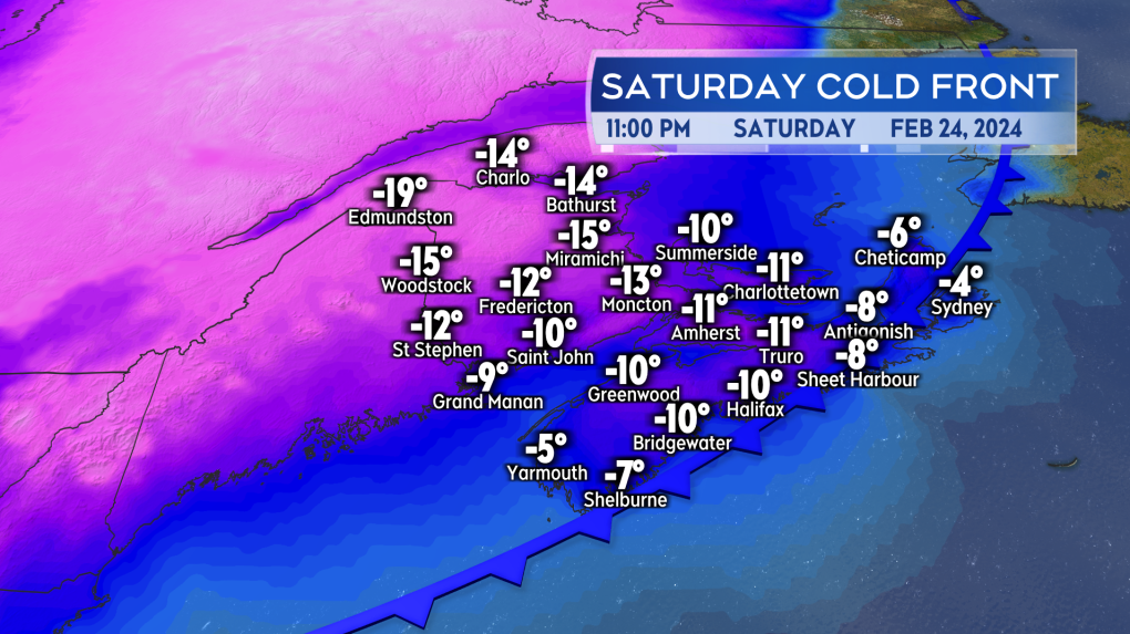 A quick fall in temperatures back below freezing follows the rain for Saturday evening and night. Icy conditions possible Saturday evening into Sunday. (CTV/Kalin Mitchell)


CTVNews.ca Top Stories

Alberta town takes action fighting crime, addressing homelessness, addictions issues
In Cold Lake, Alta., drivers leaning through windows at the McDonald’s drive-thru have been ambushed by people running by and snatching food right out of their hands.
Workplace habit of 'coffee badging' prompts reported new policy at Amazon
The term 'coffee badging' has gained some new significance this week with multiple outlets reporting Amazon is allegedly taking measures to counter the workplace trend it refers to.
Trudeau and family head to British Columbia for vacation in unnamed location
Prime Minister Justin Trudeau will head to British Columbia on Sunday, where he will be on vacation with his family until Aug. 1.
Stranger sexually assaulted Surrey woman while she was asleep in her home, RCMP say
A woman in Surrey's Newton neighbourhood woke up to a stranger groping her early Saturday morning, according to local police.
Baby dies after pregnant woman fatally struck by vehicle in downtown Toronto
A woman fatally struck by a sedan in downtown Toronto earlier this week was pregnant, and her baby has also died, police say.
'I took a bullet for democracy': Trump holds first rally after assassination attempt
Donald Trump is holding his first campaign rally since he survived an attempted assassination, returning to the battleground state of Michigan alongside his new running mate.
Democratic consensus solidifies around Harris, should Biden step aside
No one quite knows what the process of picking a new nominee would be if Joe Biden did step aside – but many Democrats say that any process is likelier than ever to quickly end with Vice President Kamala Harris as the nominee.
A 12-year-old girl is accused of smothering her younger cousin over an iPhone
A 12-year-old girl in Tennessee has been charged with murder, accused of smothering her eight-year-old cousin as the younger girl slept. A relative said they had been arguing over an iPhone.
Here are the signs you're ready to downsize your home
Amid the cost-of-living crisis, many Canadians are looking to find ways to save money, such as downsizing their home. But one Ottawa broker says there are several signs to consider before making the big decision.
Shopping Trends
The Shopping Trends team is independent of the journalists at CTV News. We may earn a commission when you use our links to shop. Read about us.


Toronto
-

LCBO confirms strike over, stores to reopen Tuesday
The Liquor Control Board of Ontario (LCBO) and the union representing 10,000 of its workers reached a tentative agreement Saturday, clearing the way for stores to open Tuesday.
-
Motorcyclist dies in hospital after crashing into tree in Scarborough
A motorcyclist has died after he crashed into a tree in Scarborough.
-
Baby dies after pregnant woman fatally struck by vehicle in downtown Toronto
A woman fatally struck by a sedan in downtown Toronto earlier this week was pregnant, and her baby has also died, police say.
Calgary
-

14 residences, 10 commercial properties impacted by new Montgomery water main break: City
A new water main break that took place close to the feeder main break that has restricted residents water use since early June is impacting 14 residences, the city said Saturday.
-
4 people hospitalized in 2-vehicle collision near Canada Olympic Park
Two adults and two children were taken to hospital Saturday when a car was struck by a pickup truck on 16 Avenue N.W. near Canada Olympic Park.
-
Wally Buono to receive Wall of Fame honour from Calgary Stampeders
When Wally Buono steps onto the field at McMahon Stadium on Sunday, he’ll soak in every moment in front of family, friends and fans.
Edmonton
-
Alberta town takes action fighting crime, addressing homelessness, addictions issues
In Cold Lake, Alta., drivers leaning through windows at the McDonald’s drive-thru have been ambushed by people running by and snatching food right out of their hands.
-
2 people found dead in western Alberta river: RCMP
Two people were found dead after going missing in the Smoky River in west-central Alberta.
-
More northern Alberta communities evacuated as hot windy weather drives extreme fire behaviour
Residents of two more northern Alberta communities were forced to leave their homes Saturday due to an encroaching wildfire.
Montreal
-

Young people around the world are swapping clothes to save the environment
Fast fashion is out and sustainability is in, according to new research from Concordia University.
-
Montreal woman feels scared after seeing drone outside her bedroom window
It's not something you like to see when you're in your apartment, laying in bed in your underwear on a hot summer day: a drone hovering outside your window.
-
Trendy Griffintown pizzeria's permits suspended after Quebec liquor board ruling
Moretti Pizzeria in Montreal's Griffintown neighbourhood, that was no stranger to police stops, fights and organized crime member visits has has its permits suspended for 25 days following a ruling from the liquor control board (RACJ).
Ottawa
-
 NEW THIS MORNING
NEW THIS MORNING How to protect yourself from West Nile virus
It's been a hot, humid and wet summer so far in Ottawa, making it the perfect breeding ground for mosquitoes and elevating the risk of West Nile virus.
-
Ottawa teacher facing sexual assault charges involving minor, police looking for other victims
The Ottawa Police Service says a teacher is facing charges related to alleged sexual assaults involving a minor under the age of 18.
-
What's happening in Ottawa this weekend: July 19-21
CTVNewsOttawa.ca looks at things to do in Ottawa this weekend.
London
-
LCBO confirms strike over, stores to reopen Tuesday
The Liquor Control Board of Ontario (LCBO) and the union representing 10,000 of its workers reached a tentative agreement Saturday, clearing the way for stores to open Tuesday.
-
Hazmat response to north London, Ont. apartment complex
Circumstances around a deceased individual in an apartment raise concerns for first responders.
-
Overnight ED closure in Wingham
The emergency department at Wingham’s hospital will be closed from 9 p.m. Saturday until 7 a.m. Sunday.
Barrie
-

LCBO strike over, local employees react to decision
While employees still picketed in front of closed LCBO stores on Saturday, many were optimistic as a tentative deal to end the strike was reached between the LCBO and the Ontario Public Service Employees Union (OPSEU).
-
Orillia veteran celebrates his 100th birthday
An Orillia veteran celebrated his centennial birthday on Saturday with a grand celebration.
-
Local leaders take part in annual dunk tank fundraiser
Local municipal leaders attended the annual dunk your local leader's event on Saturday.
Northern Ontario
-

Sudbury police investigating arson after speed camera set on fire
Six speed cameras set up around Greater Sudbury have drawn a lot of ire from residents, attracting some vandalism and police are now investigating after one was set on fire overnight.
-
Fatal motorcycle crash in northern Ont.
A 60-year-old has died following a motorcycle crash Thursday at the intersection of Highway 17 and Second Avenue in the Greater Sudbury community of Coniston on Thursday.
-
Defence for Sault murder suspect to argue he was not mentally competent
The defence lawyer for Steven Jones plans to argue that he was not mentally competent when a victim was stabbed to death and a second was seriously injured.
Kitchener
-

Third annual Scotland's Yard Road Hockey Classic returns to Kitchener
Excitement and energy filled the air Saturday as the third annual Scotland's Yard Road Hockey Classic made its much anticipated return to Kitchener.
-
LCBO confirms strike over, stores to reopen Tuesday
The Liquor Control Board of Ontario (LCBO) and the union representing 10,000 of its workers reached a tentative agreement Saturday, clearing the way for stores to open Tuesday.
-
Rockwood man killed in Highway 7 crash
Ontario Provincial Police are investigating a fatal collision involving a 78-year-old Rockwood man.
Windsor
-
LCBO confirms strike over, stores to reopen Tuesday
The Liquor Control Board of Ontario (LCBO) and the union representing 10,000 of its workers reached a tentative agreement Saturday, clearing the way for stores to open Tuesday.
-
Bringing Kabaddi Cup to WFCU Centre raises sport to 'another level' in Windsor
After being held outdoors last year, the Windsor Kabaddi Cup returned for its second annual edition this weekend inside the WFCU Centre. The Windsor Kabaddi Cup featured 60 players divided into six teams of 10, competing in the traditional Indian team sport.
-
Paws on stage: Windsor theatre group holds dog auditions for Christmas musical
A theatre group in Windsor is holding auditions for an upcoming Christmas musical production — but this time, the stars vying for the spotlight are of the four-legged variety.
Winnipeg
-

‘It looks scary, but they’re harmless’: Bees removed from Winnipeg street light
A swarm of bees living in a lamppost in Winnipeg’s Sage Creek neighbourhood has found a new home for its hive.
-
'We're famous for our skies': The science behind a Manitoba sunset
To catch a glimpse of a beautiful sunrise or sunset is one of the great wonders of nature.
-
Winnipeg police arrest man found asleep in stolen vehicle
A Winnipeg man is facing a number of charges after police found him sleeping at the wheel of a stolen vehicle Friday morning.
Regina
-

Health inspectors investigate conditions at motel after another family complains about bedbugs
Health inspectors are investigating conditions at a motel in Regina used by Social Services for emergency accommodations. It come after another family complained about being attacked by bedbugs.
-
Over 50 Nigerian entrepreneurs gather for annual trade show in the park
The fourth edition of the Nigerian Entrepreneurs Summer Hangout (NESH) took place on Saturday,
-
Riders get back in win column with victory over Bombers
The Saskatchewan Roughriders remained dominant on defence as they held Winnipeg to only field goals for points on Friday night in their 19-9 victory.
Saskatoon
-

Saskatoon's bus rapid transit gets a new name
A new transit system meant to change the way people move around Saskatoon is beginning to take shape.
-
How sheep are being used to help conserve the Meewasin Valley?
With new ranching methods, the image of a traditional shepherd with their cane and sheepdog has largely become a thing of the past. However, in the modern day, the shepherd is making a comeback, cane and all, in conservation.
-
Phone lines still down at all Saskatoon leisure centres, outdoor pools after IT outage
Saskatoon residents seeking to beat the heat at a leisure centre or outdoor pool this weekend should be aware that phone booking is unavailable.
Vancouver
-

Motorcyclist dead after crash with fire truck that closed Lions Gate Bridge
A major thoroughfare in Vancouver was shut down for several hours Saturday afternoon after a fatal crash between a fire truck and a motorcycle, officials say.
-
Stranger sexually assaulted Surrey woman while she was asleep in her home, RCMP say
A woman in Surrey's Newton neighbourhood woke up to a stranger groping her early Saturday morning, according to local police.
-
'A celebration of diversity': Surrey Fusion Festival showcases city's many cultures
Thousands of people are making their way to Surrey's Holland Park this weekend for the 17th annual Surrey Fusion Festival.
Vancouver Island
-

Tofino, B.C., plane crash victims identified online as California veterinarians
Tributes are pouring in online for the two men who died in a plane crash in Tofino, B.C. earlier this week.
-
Trudeau and family head to British Columbia for vacation in unnamed location
Prime Minister Justin Trudeau will head to British Columbia on Sunday, where he will be on vacation with his family until Aug. 1.
-
How B.C.'s firefighting smokejumpers take 'ultra-extreme and make it seem mundane'
Standing on the edge of an open aircraft hatch, a smokejumper in a pale yellow suit steadies himself before rocking back then swinging out the door and vanishing as gravity takes over.
Kelowna
-

2 dead after serious crash on Highway 1 in B.C. Interior
Two people are dead after a serious crash that shut down Highway 1 near Sorrento, B.C. Saturday morning.
-
Structures lost to Shetland Creek wildfire as more heat, thunderstorms strike parts of B.C.
The number of wildfires in British Columbia has flared as more lightning storms bring the potential for further fire starts.
-
How B.C.'s firefighting smokejumpers take 'ultra-extreme and make it seem mundane'
Standing on the edge of an open aircraft hatch, a smokejumper in a pale yellow suit steadies himself before rocking back then swinging out the door and vanishing as gravity takes over.


